Rocky Brushy Creek Watershed Mgmt. Plan (2007) -- Part 2
Rocky Brushy Creek Watershed Mgmt. Plan (2007) -- Part 2 Rocky Brushy Creek Watershed Mgmt. Plan (2007) -- Part 2
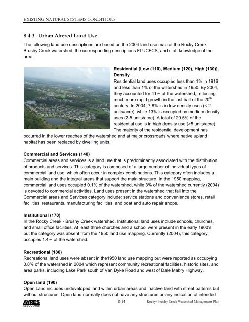
EXISTING NATURAL SYSTEMS CONDITIONS8.4.3 Urban Altered Land UseThe following land use descriptions are based on the 2004 land use map of the Rocky Creek -Brushy Creek watershed, the corresponding descriptions FLUCFCS, and staff knowledge of thearea.Residential [Low (110), Medium (120), High (130)],DensityResidential land uses occupied less than 1% in 1916and less than 1% of the watershed in 1950. By 2004,they accounted for 41% of the watershed, reflectingmuch more rapid growth in the last half of the 20 thcentury. In 2004, 7.8% is in low density uses (< 2units/acre), while 13% is occupied by medium densityuses (2-5 units/acre). A total of 20.5% of theresidential use is in high density use (>5 units/acre).The majority of the residential development hasoccurred in the lower reaches of the watershed and at major crossroads where native uplandhabitat has been replaced by dwelling units.Commercial and Services (140)Commercial areas and services is a land use that is predominantly associated with the distributionof products and services. This category is composed of a large number of individual types ofcommercial land use, which often occur in complex combinations. This category often includes amain building and the integral areas that support the main structure. In the 1950 mapping,commercial land uses occupied 0.1% of the watershed, while 3% of the watershed currently (2004)is devoted to commercial activities. Land uses present in the watershed that fall into theCommercial areas and Services category include: service stations and convenience stores, retailfacilities, restaurants, manufacturing facilities, and boat and auto repair shops.Institutional (170)In the Rocky Creek - Brushy Creek watershed, Institutional land uses include schools, churches,and small office facilities. At least three churches and a school were present in the early 1900’s,but the category was absent from the 1950 land use mapping. Currently (2004), this categoryoccupies 1.4% of the watershed.Recreational (180)Recreational land uses were absent in the1950 land use mapping but were reported as occupying0.8% of the watershed in 2004 which represent community recreational facilities, historic sites, andarea parks, including Lake Park south of Van Dyke Road and west of Dale Mabry Highway.Open land (190)Open Land includes undeveloped land within urban areas and inactive land with street patterns butwithout structures. Open land normally does not have any structures or any indication of intended8-14Rocky/Brushy Creek Watershed Management Plan
CHAPTER 8use. Urban inactive land is often in a transitional state and will eventually be developed into one ofthe typical urban land uses. Absent in 1950, open land increased in areal coverage slightly to 3%.Cropland and Pastureland (210)Formerly occupying 12.4% of the watershed in 1950, this land use category has decreased to6.1% of the watershed in 2004. Included here are chiefly pastures with some vegetable and smallfruit crops.Tree Crops (220)In the Rocky Creek - Brushy Creek watershed, thiscategory includes citrus groves which are locatedchiefly in the central region of the watershed. Citrusproduction was well established by 1938 andoccupied 6.9% in 1950; it decreased to 0.9% of thewatershed by 2004 as lands were converted fromcitrus to residential and commercial uses.Nurseries and Vineyards (240)This category, composed of nurseries, was absent inthe 1950 land use mapping but now occupies 0.4% of the watershed and is represented facilitiessupplying plants for residential landscaping.Specialty Farms (250)Specialty farms currently occupy 0.4% of the watershed and include kennels.Other Open Lands (260)Other open lands are agricultural land with a use that cannot be determined from availableimagery. In 1950, 0.1% of the watershed fell into this category. By 2004, this category occupied0.9% of the watershed and represents lands that are resting between crops.Disturbed Land (740)Representing 0.2% of the watershed, disturbed lands are areas that have been changed primarilydue to human activities other than mining and include rural lands in transition to residential landuses, and temporary spoil sites.Transportation (810)In the Rocky Creek - Brushy Creek watershed, railroads and paved roadways have occupied thewatershed since the late 1890’s and early 1900’s. This land cover type increased from 0.1% of thewatershed in 1950 to 2.7% in 2004 as early facilities were expanded and new facilities wereconstructed.8-15Rocky/Brushy Creek Watershed Management Plan
- Page 25 and 26: CHAPTER 8Factors such as the width
- Page 27 and 28: State Road 54Pasco CountyHillsborou
- Page 29 and 30: CHAPTER 88.5.4 Biological Indicator
- Page 31 and 32: State Road 54Pasco CountyHillsborou
- Page 33 and 34: CHAPTER 8The presence of wildlife o
- Page 35 and 36: CHAPTER 8Table 8-9Protected Animal
- Page 37 and 38: CHAPTER 8problems; and8. informing
- Page 39 and 40: CHAPTER 8the entire surface of some
- Page 41 and 42: CHAPTER 8Wild TaroThe wild taro is
- Page 43 and 44: CHAPTER 8The FDEP Bureau of Land Ac
- Page 45 and 46: State Road 54Pasco CountyHillsborou
- Page 47 and 48: CHAPTER 8Funding Program (NRTFP). T
- Page 49 and 50: CHAPTER 8Hillsborough CountyWetland
- Page 51 and 52: CHAPTER 84. Hillsborough County Str
- Page 53 and 54: CHAPTER 8innovative, interdisciplin
- Page 55 and 56: CHAPTER 8• Developing and support
- Page 57 and 58: CHAPTER 88.9 BibliographyThe attach
- Page 59 and 60: CHAPTER 8Southwest Florida Water Ma
- Page 61 and 62: CHAPTER 8Chinese laddere brake, Pte
- Page 63 and 64: CHAPTER 8: EXISTING NATURAL SYSTEMS
- Page 65 and 66: CHAPTER 8Using the data described i
- Page 67 and 68: CHAPTER 8Land uses and cover types
- Page 69 and 70: LegendRoadsHydrographyAgriculturalB
- Page 71 and 72: CHAPTER 8Hardwood conifer mixed for
- Page 73 and 74: CHAPTER 8Mangrove swamps (612)The a
- Page 75: CHAPTER 8consist solely of mud into
- Page 79 and 80: CHAPTER 8enhance drainage for rows
- Page 81 and 82: State Road 54Pasco CountyHillsborou
- Page 83 and 84: State Road 54Pasco CountyHillsborou
- Page 85 and 86: CHAPTER 8buffer zones should be est
- Page 87 and 88: CHAPTER 8Factors such as the width
- Page 89 and 90: State Road 54Pasco CountyHillsborou
- Page 91 and 92: CHAPTER 88.5.4 Biological Indicator
- Page 93 and 94: State Road 54Pasco CountyHillsborou
- Page 95 and 96: CHAPTER 8The presence of wildlife o
- Page 97 and 98: CHAPTER 8Table 8-9Protected Animal
- Page 99 and 100: CHAPTER 8problems; and8. informing
- Page 101 and 102: CHAPTER 8the entire surface of some
- Page 103 and 104: CHAPTER 8Wild TaroThe wild taro is
- Page 105 and 106: CHAPTER 8The FDEP Bureau of Land Ac
- Page 107 and 108: State Road 54Pasco CountyHillsborou
- Page 109 and 110: CHAPTER 8Funding Program (NRTFP). T
- Page 111 and 112: CHAPTER 8Hillsborough CountyWetland
- Page 113 and 114: CHAPTER 84. Hillsborough County Str
- Page 115 and 116: CHAPTER 8innovative, interdisciplin
- Page 117 and 118: CHAPTER 8• Developing and support
- Page 119 and 120: CHAPTER 88.9 BibliographyThe attach
- Page 121 and 122: CHAPTER 8Southwest Florida Water Ma
- Page 123 and 124: CHAPTER 8Chinese laddere brake, Pte
- Page 125 and 126: CHAPTER 9: WATER SUPPLY9.1 Overview
EXISTING NATURAL SYSTEMS CONDITIONS8.4.3 Urban Altered Land UseThe following land use descriptions are based on the 2004 land use map of the <strong>Rocky</strong> <strong>Creek</strong> -<strong>Brushy</strong> <strong>Creek</strong> watershed, the corresponding descriptions FLUCFCS, and staff knowledge of thearea.Residential [Low (110), Medium (120), High (130)],DensityResidential land uses occupied less than 1% in 1916and less than 1% of the watershed in 1950. By 2004,they accounted for 41% of the watershed, reflectingmuch more rapid growth in the last half of the 20 thcentury. In 2004, 7.8% is in low density uses (< 2units/acre), while 13% is occupied by medium densityuses (2-5 units/acre). A total of 20.5% of theresidential use is in high density use (>5 units/acre).The majority of the residential development hasoccurred in the lower reaches of the watershed and at major crossroads where native uplandhabitat has been replaced by dwelling units.Commercial and Services (140)Commercial areas and services is a land use that is predominantly associated with the distributionof products and services. This category is composed of a large number of individual types ofcommercial land use, which often occur in complex combinations. This category often includes amain building and the integral areas that support the main structure. In the 1950 mapping,commercial land uses occupied 0.1% of the watershed, while 3% of the watershed currently (2004)is devoted to commercial activities. Land uses present in the watershed that fall into theCommercial areas and Services category include: service stations and convenience stores, retailfacilities, restaurants, manufacturing facilities, and boat and auto repair shops.Institutional (170)In the <strong>Rocky</strong> <strong>Creek</strong> - <strong>Brushy</strong> <strong>Creek</strong> watershed, Institutional land uses include schools, churches,and small office facilities. At least three churches and a school were present in the early 1900’s,but the category was absent from the 1950 land use mapping. Currently (2004), this categoryoccupies 1.4% of the watershed.Recreational (180)Recreational land uses were absent in the1950 land use mapping but were reported as occupying0.8% of the watershed in 2004 which represent community recreational facilities, historic sites, andarea parks, including Lake Park south of Van Dyke Road and west of Dale Mabry Highway.Open land (190)Open Land includes undeveloped land within urban areas and inactive land with street patterns butwithout structures. Open land normally does not have any structures or any indication of intended8-14<strong>Rocky</strong>/<strong>Brushy</strong> <strong>Creek</strong> <strong>Watershed</strong> Management <strong>Plan</strong>


