EXISTING NATURAL SYSTEMS CONDITIONS8.4.1 Upland Natural SystemsThe following upland habitat descriptions are based on the information contained in Harper (1921),Carlisle et al. (1978), Florida Department of Transportation’s FLUCFCS Manual (1999), and theSoil Surveys of Hillsborough County from 1916, 1958, and 1989. In the plant communitydescriptions below, only the species that are most characteristic of the plant community in the<strong>Rocky</strong>/<strong>Brushy</strong> <strong>Creek</strong> watershed are mentioned as being present; however, the natural plantcommunities that still remain in the watershed are highly diverse and contain many more speciesthan are mentioned in this report. For ease of reading, only common names of plants are used inthe report narrative, but Section 8.10 provides a list of all scientific names of plants and animalsincluded in the report.Pine flatwoods (411)The most common upland plant community in the state and in the <strong>Rocky</strong> <strong>Creek</strong> - <strong>Brushy</strong> <strong>Creek</strong>watershed is the pine flatwoods community which is associated with Malabar fine sands andImmokalee fine sands. The primary canopy species common to pine flatwoods is slash pine withsome longleaf pine, while the shrubby understory is dominated by saw palmetto with somegallberry, staggerbush, blueberry, and tarflower. Herbaceous ground cover is sparse and includeswiregrass, several species of bluestem, and goldenrod. This community occurs on flat, moderatelyto poorly drained terrain composed of acid sands overlying an organic/clayey hardpan. Even onbetter drained terrain, flatwoods can experience periods of inundation when rainfall amounts are inthe normal to above normal range. On less well drained terrain, a wet phase of pine flatwoodsoccurs in which obligate to facultative-wet plant species can be found flatwoods regularly. Thesespecies include trees: sweetbay, gordonia, red maple; shrubs: wax myrtle, gallberry, fetterbush;and herbs: spikerush, redroot, bog buttons, pink sundews, and yellow-eyed grass. Pine flatwoodsis a fire-maintained community that will transition to a hardwood-dominated community with verydense canopy dominated by live oak, laurel oak, and pignut hickory if fire is excluded. In the <strong>Rocky</strong><strong>Creek</strong> - <strong>Brushy</strong> <strong>Creek</strong> watershed, pine flatwoods have been used for pasture, row crops, and (withdrainage) some citrus. Pine flatwoods now occupies only 1% of the watershed.Longleaf pine-xeric oak (412)The longleaf pine - xeric oak plant community, also known as sandhill, is associated with Norfolkfine sands in the <strong>Rocky</strong> <strong>Creek</strong> - <strong>Brushy</strong> <strong>Creek</strong> watershed. Natural canopy vegetation is dominatedby longleaf pine, and characteristically has a mid-canopy of bluejack oak, turkey oak, sand liveoak. The understory contains a medium to low density shrub community consisting of shinyblueberry, Darrow’s blueberry, gopher apple, Adam’s needle, and beautyberry. Herbs compose theground cover and include: wiregrass, sky-blue lupine, drumheads, Carolina elephant’s foot, dwarfpawpaw, and eastern milk pea. This community also is a fire-maintained community that willtransition to a hardwood-dominated community with few to no pines and a very dense canopydominated by sand live oak, turkey oak, bluejack oak if fire is excluded. This plant community waslargely replaced by citrus by 1950. Currently (2004), this community occupies 0.3% of thewatershed.8-8<strong>Rocky</strong>/<strong>Brushy</strong> <strong>Creek</strong> <strong>Watershed</strong> Management <strong>Plan</strong>
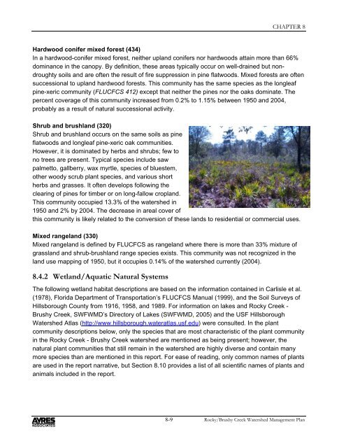
CHAPTER 8Hardwood conifer mixed forest (434)In a hardwood-conifer mixed forest, neither upland conifers nor hardwoods attain more than 66%dominance in the canopy. By definition, these areas typically occur on well-drained but nondroughtysoils and are often the result of fire suppression in pine flatwoods. Mixed forests are oftensuccessional to upland hardwood forests. This community has the same species as the longleafpine-xeric community (FLUCFCS 412) except that neither the pines nor the oaks dominate. Thepercent coverage of this community increased from 0.2% to 1.15% between 1950 and 2004,probably as a result of natural successional activity.Shrub and brushland (320)Shrub and brushland occurs on the same soils as pineflatwoods and longleaf pine-xeric oak communities.However, it is dominated by herbs and shrubs; few tono trees are present. Typical species include sawpalmetto, gallberry, wax myrtle, species of bluestem,other woody scrub plant species, and various shortherbs and grasses. It often develops following theclearing of pines for timber or on long-fallow cropland.This community occupied 13.3% of the watershed in1950 and 2% by 2004. The decrease in areal cover ofthis community is likely related to the conversion of these lands to residential or commercial uses.Mixed rangeland (330)Mixed rangeland is defined by FLUCFCS as rangeland where there is more than 33% mixture ofgrassland and shrub-brushland range species exists. This community was not recognized in theland use mapping of 1950, but it occupies 0.14% of the watershed currently (2004).8.4.2 Wetland/Aquatic Natural SystemsThe following wetland habitat descriptions are based on the information contained in Carlisle et al.(1978), Florida Department of Transportation’s FLUCFCS Manual (1999), and the Soil Surveys ofHillsborough County from 1916, 1958, and 1989. For information on lakes and <strong>Rocky</strong> <strong>Creek</strong> -<strong>Brushy</strong> <strong>Creek</strong>, SWFWMD’s Directory of Lakes (SWFWMD, 2005) and the USF Hillsborough<strong>Watershed</strong> Atlas (http://www.hillsborough.wateratlas.usf.edu) were consulted. In the plantcommunity descriptions below, only the species that are most characteristic of the plant communityin the <strong>Rocky</strong> <strong>Creek</strong> - <strong>Brushy</strong> <strong>Creek</strong> watershed are mentioned as being present; however, thenatural plant communities that still remain in the watershed are highly diverse and contain manymore species than are mentioned in this report. For ease of reading, only common names of plantsare used in the report narrative, but Section 8.10 provides a list of all scientific names of plants andanimals included in the report.8-9<strong>Rocky</strong>/<strong>Brushy</strong> <strong>Creek</strong> <strong>Watershed</strong> Management <strong>Plan</strong>