TNSSNT SNT FUN TNSSNT FUN SNT - German Flight-Center
TNSSNT SNT FUN TNSSNT FUN SNT - German Flight-Center
TNSSNT SNT FUN TNSSNT FUN SNT - German Flight-Center

You also want an ePaper? Increase the reach of your titles
YUMPU automatically turns print PDFs into web optimized ePapers that Google loves.
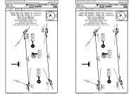
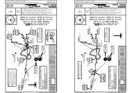
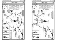
Licensed to Elefant air. Printed on 15 Jul 2009.Notice: After 17 Jul 2009 0901Z, this chart may no longer be valid. Disc 13-2009LPMA/FNCMADEIRAATIS124.4Apt Elev192'22 MAY 09JEPPESEN10-2.Eff.4.Jun.Alt Set: hPaTrans level: By ATC Trans alt: 5000'LIDRO 4A [LIDR4A]NIDUL 4A [NIDU4A]RWYS 05, 23 RNAV ARRIVALSFOR SPECIAL PROCEDURES AND OPERATINGLIMITATIONS SEE CHARTS 10-6 TO 10-6BClearance limit is ABUSU at 3000'.JEPPESENJeppView 3.6.3.0MADEIRA, MADEIRA IS.RNAV.STAR.146^8200'026^3500'MSA<strong>FUN</strong> VORLIDRON33 40.1 W015 57.0232^Licensed to Elefant air. Printed on 15 Jul 2009.Notice: After 17 Jul 2009 0901Z, this chart may no longer be valid. Disc 13-2009LPMA/FNCMADEIRAATIS124.4Apt Elev192'22 MAY 09JEPPESEN10-2A.Eff.4.Jun.Alt Set: hPaTrans level: By ATC Trans alt: 5000'BIMBO 3A [BIMB3A], MADAT 3ANIKAV 3A [NIKA3A], SANTO 3A (<strong>SNT</strong> 3A)RWYS 05, 23 ARRIVALSFOR SPECIAL PROCEDURES AND OPERATINGLIMITATIONS SEE CHARTS 10-6 TO 10-6BClearance limit is ABUSU at 3000'.JEPPESENJeppView 3.6.3.0MADEIRA, MADEIRA IS[MADA3A]146^8200'026^.STAR.3500'MSA<strong>FUN</strong> VORTOBEDN33 14.3 W016 28.4374000LIDRO 4ANIKAVN33 20.9 W016 52.4126^22LOST COMMS LOST COMMS LOST COMMSALTERNATE HOLDINGTo be used in case ofcommunication failure.XINGAN33 03.0 W017 08.6093^ FL100LOST COMMSD40LOST COMMS<strong>SNT</strong>114.9R273^TNSLOST COMMSLOST COMMS LOST COMMS243000207^D<strong>SNT</strong>PORTO SANTO114.9 <strong>SNT</strong>N33 05.4 W016 21.0LOST COMMS LOST COMMS LOST COMMSALTERNATE HOLDINGTo be used in case ofcommunication failure.XINGAN33 03.0 W017 08.6093^LOST COMMSFL100D40LOST COMMS<strong>SNT</strong>114.9R273^TNSNIKAV 3ALOST COMMS4000LOST COMMS LOST COMMS30001913212^(IAF)IRSANN33 10.0W016 30.3(<strong>SNT</strong> D9)9<strong>SNT</strong> 3AD9 <strong>SNT</strong>N33 03.2W016 31.4262^4000D<strong>SNT</strong>PORTO SANTO114.9 <strong>SNT</strong>N33 05.4 W016 21.03000D(IAF)<strong>FUN</strong>CHAL112.2 <strong>FUN</strong>N32 44.8 W016 42.3027^D830003000032^(IAF)ABUSUN32 52.0 W016 38.1D(IAF)<strong>FUN</strong>CHAL112.2 <strong>FUN</strong>N32 44.8 W016 42.3R215^D032^8R172^3000R163^(IAF)ABUSUN32 52.0 W016 38.1R215^D9FUSULN32 36.1 W016 39.7NOT TO SCALE255000405000MADAT 3A4000352^864000BIMBO 3ANIDULN32 21.9W017 21.2094^21FL100NIDUL 4A035^XERONN32 22.9 W016 56.6NOT TO SCALE035^MADATN32 09.7 W017 05.1STARLIDRO 4A LIDRO - TOBED - ABUSU.NIDUL 4A NIDUL - XERON - <strong>FUN</strong> - ABUSU.CHANGES: Holding over ABUSU.ROUTING| JEPPESEN, 2003, 2009. ALL RIGHTS RESERVED.CHANGES: None.343^BIMBON31 25.3 W016 02.0| JEPPESEN, 2003, 2009. ALL RIGHTS RESERVED.
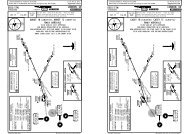
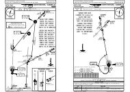
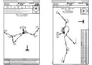
Licensed to Elefant air. Printed on 15 Jul 2009.Notice: After 17 Jul 2009 0901Z, this chart may no longer be valid. Disc 13-2009LPMA/FNCMADEIRAMADEIRA Approach119.2Apt Elev192'2000Rosario2041'1000JEPPESENTrans level: By ATC Trans alt: 5000'1. Contact MADEIRA Approach immediately after take-off.2. Pilots are advised to select full power on take-off inthe presence of turbulence or downdraft reports.3. Take-off must be made in a minimum visibility of 2800m.Required take-off alternate.4. Each operator must prepare its own engine failureprocedures.DEGUN 2N [DEGU2N], DEGUN 2S [DEGU2S]RWYS 05, 23 RNAV DEPARTURESFOR SPECIAL PROCEDURES AND OPERATINGLIMITATIONS SEE CHARTS 10-6 TO 10-6BImmediately after take-off and at 100' minimum(150' when using QFE for threshold runway 05or 300' using QNH) or at runway end, whichevercomes first, turn RIGHT to avoid high ground onthe LEFT side.1129'D24 APR 09 10-3<strong>FUN</strong>CHAL112.2 <strong>FUN</strong>N32 44.8 W016 42.3DEGUN 2NDEGUN 2S.Eff.7.May.22055^JEPPESENJeppView 3.6.3.0MADEIRA, MADEIRA ISXAVALN32 43.5 W016 29.9DEGUNN33 25.1 W015 39.5050^37146^8200'POBARN32 57.9 W016 09.9.RNAV.SID.026^3500'MSA<strong>FUN</strong> VORLicensed to Elefant air. Printed on 15 Jul 2009.Notice: After 17 Jul 2009 0901Z, this chart may no longer be valid. Disc 13-2009LPMA/FNCMADEIRAMADEIRA Approach119.2Apt Elev192'NIDUL 2N[NIDU2N],000JEPPESENFOR SPECIAL PROCEDURES AND OPERATINGLIMITATIONS SEE CHARTS 10-6 TO 10-6B3400000054000NIDUL 2S[NIDU2S]RWYS 05, 23 RNAV DEPARTURES3000100010-3ATrans level: By ATC Trans alt: 5000'1. Contact MADEIRA Approach immediately after take-off.2. Pilots are advised to select full power on take-off inthe presence of turbulence or downdraft reports.3. Take-off must be made in a minimum visibility of 2800m.Required take-off alternate.4. Each operator must prepare its own engine failureprocedures.Immediately after take-off and at100' minimum (50' when using QFEfor threshold runway 23 or 250'using QNH) or at runway end,whichever comes first, turn LEFT.Keep to the LEFT of the coastline.24 APR 0920002000.Eff.7.May.Immediately after take-off and at 100' minimum(150' when using QFE for threshold runway 05or 300' using QNH) or at runway end, whichevercomes first, turn RIGHT to avoid high ground onthe LEFT side.2034'Rosario215^NIDUL 2S178^2041'10001129'NIDUL 2N213^JEPPESENJeppView 3.6.3.0MADEIRA, MADEIRA ISNOT TO SCALEOUTSIDE THIS AREAD11 <strong>FUN</strong>N32 34.9 W016 48.0Afteror above146^8200'D11 <strong>FUN</strong>3500'.RNAV.SID.026^3500'MSA<strong>FUN</strong> VOR<strong>FUN</strong>CHALD112.2 <strong>FUN</strong>N32 44.8 W016 42.3XAVAL - POBAR - DEGUN.NOT TO SCALE OUTSIDE THIS AREAImmediately after take-off and at 100' minimum(50' when using QFE for threshold runway 23 or250' using QNH) or at runway end, whichevercomes first, turn LEFT.Keep to the LEFT of the coastline.CHANGES: RNAV SIDs renumbered & revised; chart reindexed.Rwy 23:With westerly winds, tailwind shears maybe expected. Anemometer readings reported byTower at the end of the runway and at Rosariomay indicate this possibility.Initial climb clearance FL60ROUTING| JEPPESEN, 2003, 2009. ALL RIGHTS RESERVED.NIDULN32 21.9 W017 21.2SID RWYNIDUL 2N 05NIDUL 2S 2321274^CHANGES: RNAV SIDs renumbered; chart reindexed.XERONN32 22.9 W016 56.6At XERONor at FL100whichever is earlierRwy 23:With westerly winds, tailwind shears maybe expected. Anemometer readings reported byTower at the end of the runway and at Rosariomay indicate this possibility.Initial climb clearance FL100ROUTINGIntercept <strong>FUN</strong> R-213, after D11 <strong>FUN</strong> or above 3500' turn RIGHT, intercept<strong>FUN</strong> R-215 to XERON, at XERON or at FL100, whichever is earlier, turnRIGHT to NIDUL.On 178^ track, intercept <strong>FUN</strong> R-213, after D11 <strong>FUN</strong> or above 3500' turnRIGHT, intercept <strong>FUN</strong> R-215 to XERON, at XERON or at FL100 , whicheveris earlier, turn RIGHT to NIDUL.| JEPPESEN, 2003, 2009. ALL RIGHTS RESERVED.
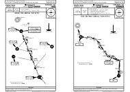
Licensed to Elefant air. Printed on 15 Jul 2009.Notice: After 17 Jul 2009 0901Z, this chart may no longer be valid. Disc 13-2009LPMA/FNCMADEIRAMADEIRA Approach119.2Apt Elev192'JEPPESEN24 APR 09 10-3B.Eff.7.May.Trans level: By ATC Trans alt: 5000'1. Contact MADEIRA Approach immediately after take-off.2. Pilots are advised to select full power on take-off inthe presence of turbulence or downdraft reports.3. Take-off must be made in a minimum visibility of 2800m.Required take-off alternate.4. Each operator must prepare its own engine failureprocedures.IRKID 5N [IRKI5N], IRKID 5S [IRKI5S]RWYS 05, 23 DEPARTURESFOR SPECIAL PROCEDURES AND OPERATINGLIMITATIONS SEE CHARTS 10-6 TO 10-6BJEPPESENJeppView 3.6.3.0MADEIRA, MADEIRA IS146^8200'026^MSA<strong>FUN</strong> VOR.SID.3500'Licensed to Elefant air. Printed on 15 Jul 2009.Notice: After 17 Jul 2009 0901Z, this chart may no longer be valid. Disc 13-2009LPMA/FNCMADEIRAMADEIRA Approach119.2Apt Elev192'24 APR 09JEPPESEN10-3C.Eff.7.May.Trans level: By ATC Trans alt: 5000'1. Contact MADEIRA Approach immediately after take-off.2. Pilots are advised to select full power on take-off inthe presence of turbulence or downdraft reports.3. Take-off must be made in a minimum visibility of 2800m.Required take-off alternate.4. Each operator must prepare its own engine failureprocedures.MADAT 5N [MADA5N], MADAT 5S [MADA5S]RWYS 05, 23 DEPARTURESFOR SPECIAL PROCEDURES AND OPERATINGLIMITATIONS SEE CHARTS 10-6 TO 10-6BJEPPESENJeppView 3.6.3.0MADEIRA, MADEIRA IS146^8200'026^.SID.3500'MSA<strong>FUN</strong> VORIRKIDN33 55.5 W018 04.2Rwy 23: With westerly winds, tailwind shears maybe expected. Anemometer readings reported byTower at the end of the runway and at Rosariomay indicate this possibility.Immediately after take-off and at 100' minimum(150' when using QFE for threshold runway 05or 300' using QNH) or at runway end, whichevercomes first, turn RIGHT to avoid high ground onthe LEFT side.300020002034'D<strong>FUN</strong>CHAL112.2 <strong>FUN</strong>N32 44.8 W016 42.3321^4000322^Above 3000'2041'1000300020002034'D<strong>FUN</strong>CHAL112.2 <strong>FUN</strong>N32 44.8 W016 42.300054000Rosario1129'213^179^6110'6000500040004000300010002000RosarioNOT TO SCALE OUTSIDE THIS AREA1129'Immediately after take-off and at100' minimum (50' when using QFEfor threshold runway 23 or 250'using QNH) or at runway end,whichever comes first, turn LEFT.Keep to the LEFT of the coastline.2041'1000078^088^IRKID5N169^IRKID 5S338^After passing<strong>FUN</strong> R-179and above 1500'After passing<strong>FUN</strong> R-169and above 1500'Immediately after take-off and at100' minimum (150' when using QFEfor threshold runway 05 or 300'using QNH) or at runway end, which-ever comes first, turn RIGHT to avoidhigh ground on the LEFT sideImmediately after take-off and at100' minimum (50' when using QFEfor threshold runway 23 or 250'using QNH) or at runway end,whichever comes first, turn LEFT.Keep to the LEFT of the coastline.3000100020002012'215^MADAT 5S178^MADAT 5NNOT TO SCALEOUTSIDE THIS AREAD11 <strong>FUN</strong>N32 34.9 W016 48.0Afteror aboveD11 <strong>FUN</strong>3500'SIDIRKID 5NRWY05IRKID 5S 23CHANGES: SIDs renumbered; chart reindexed.Initial climb clearanceFL60ROUTINGOn 088^ track, after passing <strong>FUN</strong> R-179 (abeam <strong>FUN</strong>) and above 1500' turnLEFT, 338^ track keeping <strong>FUN</strong> LEFT hand, above 3000' intercept <strong>FUN</strong> R-322to IRKID, do not overshoot <strong>FUN</strong> R-321 to the south.On 078^ track, after passing <strong>FUN</strong> R-169 (abeam <strong>FUN</strong>) and above 1500' turnLEFT, 338^ track keeping <strong>FUN</strong> LEFT hand, above 3000' intercept <strong>FUN</strong> R-322to IRKID, do not overshoot <strong>FUN</strong> R-321 to the south.| JEPPESEN, 2003, 2009. ALL RIGHTS RESERVED.SIDMADAT 5NMADAT 5SMADATN32 09.7 W017 05.1RWY0523CHANGES: SIDs renumbered; chart reindexed.Initial climb clearanceRwy 23:With westerly winds, tailwind shears maybe expected. Anemometer readings reported byTower at the end of the runway and at Rosariomay indicate this possibility.FL60ROUTINGIntercept <strong>FUN</strong> R-213, after D11 <strong>FUN</strong> or above 3500' turn RIGHT, intercept<strong>FUN</strong> R-215 to MADAT.On 178^ track, intercept <strong>FUN</strong> R-213, after D11 <strong>FUN</strong> or above 3500' interintercept<strong>FUN</strong> R-215 to MADAT.| JEPPESEN, 2003, 2009. ALL RIGHTS RESERVED.
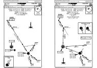
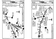
DMER184^17004^Licensed to Elefant air. Printed on 15 Jul 2009.Notice: After 17 Jul 2009 0901Z, this chart may no longer be valid. Disc 13-2009LPMA/FNCMADEIRAMADEIRA Approach119.2Apt Elev192'5000300020004000300020001000400 024 APR 092034'RosarioJEPPESENORTIS 5N [ORTI5N], ORTIS 5SRWYS 05, 23 DEPARTURESFOR SPECIAL PROCEDURES AND OPERATINGLIMITATIONS SEE CHARTS 10-6 TO 10-6B148^10-3DTrans level: By ATC Trans alt: 5000'1. Contact MADEIRA Approach immediately after take-off.2. Pilots are advised to select full power on take-off inthe presence of turbulence or downdraft reports.3. Take-off must be made in a minimum visibility of 2800m.Required take-off alternate.4. Each operator must prepare its own engine failureprocedures.Immediately after take-off and at 100' minimum(150' when using QFE for threshold runway 05or 300' using QNH) or at runway end, whichevercomes first, turn RIGHT to avoid high ground onthe LEFT side.Immediately after take-off and at 100' minimum(50' when using QFE for threshold runway 23 or250' using QNH) or at runway end, whichevercomes first, turn LEFT.Keep to the LEFT of the coastline.Rwy 23:With westerly winds, tailwind shears maybe expected. Anemometer readings reported byTower at the end of the runway and at Rosariomay indicate this possibility.SID RWYORTIS 5N 05ORTIS 5S 23CHANGES: ORTIS SIDs established; DEGUN SIDs transferred.2041'10001129'.Eff.7.May.[ORTI5S]ORTIS 5SInitial climb clearance FL60181^JEPPESENJeppView 3.6.3.0MADEIRA, MADEIRA ISNOT TO SCALEOUTSIDE THISAREADGOSGAN32 04.9 W016 37.9ORTISN31 24.4 W016 33.4ROUTINGIntercept <strong>FUN</strong> R-181 to GOSGA, then to ORTIS.On 148^ track, intercept R-181 to GOSGA, then to ORTIS.ORTIS 5N41146^8200'026^MSA<strong>FUN</strong> VOR<strong>FUN</strong>CHAL112.2 <strong>FUN</strong>N32 44.8 W016 42.3.SID.3500'| JEPPESEN, 2003, 2009. ALL RIGHTS RESERVED.Licensed to Elefant air. Printed on 15 Jul 2009.Notice: After 17 Jul 2009 0901Z, this chart may no longer be valid. Disc 13-2009LPMA/FNCMADEIRAMADEIRA Approach119.210002RosarioApt Elev192'0002041'088^078^179^3 DME<strong>SNT</strong> 5E, 5N169^JEPPESENSANTO 5E (<strong>SNT</strong> 5E), SANTO 5F (<strong>SNT</strong> 5F)SANTO 5N (<strong>SNT</strong> 5N), SANTO 5S (<strong>SNT</strong> 5S)RWYS 05, 23 DEPARTURESNOT TO SCALEOUTSIDE THISAREAFOR SPECIAL PROCEDURES AND OPERATINGLIMITATIONS SEE CHARTS 10-6 TO 10-6BD24 APR 09410-3ETrans level: By ATC Trans alt: 5000'1. Contact MADEIRA Approach immediately after take-off.2. Pilots are advised to select full power on take-off inthe presence of turbulence or downdraft reports.3. Take-off must be made in a minimum visibility of 2800m.Required take-off alternate.4. Each operator must prepare its own engine failureprocedures.Immediately after take-off and at 100' minimum(150' when using QFE for threshold runway 05or 300' using QNH) or at runway end, whichevercomes first, turn RIGHT to avoid high ground onthe LEFT side.1129'<strong>FUN</strong>CHAL112.2 <strong>FUN</strong>N32 44.8 W016 42.3<strong>SNT</strong>N32 45.8W016 35.5086^5F, 5SAfter passing<strong>FUN</strong> R-169or 1500'Immediately after take-off and at 100' minimum(50' when using QFE for threshold runway 23 or250' using QNH) or at runway end, whichevercomes first, turn LEFT.Keep to the LEFT of the coastline..Eff.7.May.JEPPESENJeppView 3.6.3.0MADEIRA, MADEIRA ISDN33 05.4 W016 21.0After passing<strong>FUN</strong> R-179and crossing4 DME<strong>SNT</strong> 5Eand above1500'039^ 22<strong>SNT</strong> 5Nand not below1500'Initial climb clearance FL60<strong>SNT</strong> 5N, 5SSID RWYROUTING<strong>SNT</strong> 5E 05 On 088^ track, after passing <strong>FUN</strong> R-179 (abeam <strong>FUN</strong>) and crossing <strong>FUN</strong> 4 DME1and above 1500' intercept 039^ bearing towards PST, intercept <strong>FUN</strong> R-086,intercept <strong>SNT</strong> R-184 inbound to <strong>SNT</strong>.<strong>SNT</strong> 5F 23 On 078^ track, after passing <strong>FUN</strong> R-169 (abeam <strong>FUN</strong>) or 1500' intercept 039^2bearing towards PST, keep beyond <strong>FUN</strong> 3 DME, intercept <strong>FUN</strong> R-086, intercept<strong>SNT</strong> R-184 inbound to <strong>SNT</strong>.<strong>SNT</strong> 5N 05 On 088^ track, after passing <strong>FUN</strong> R-179 (abeam <strong>FUN</strong>) and crossing <strong>FUN</strong> 4 DME1and not below 1500' intercept 039^ bearing to PST, then to <strong>SNT</strong>.<strong>SNT</strong> 5S 23 On 078^ track, after passing <strong>FUN</strong> R-169 (abeam <strong>FUN</strong>) or 1500' intercept 039^bearing to PST, keep beyond <strong>FUN</strong> 3 DME, then to <strong>SNT</strong>.1 To be used pending traffic conditions and for traffic landing at LPPS.2 Alternate for <strong>SNT</strong> 5S. To be used for landing at LPPS runway 36.CHANGES: SIDs renumbered & revised; chart reindexed.<strong>SNT</strong>338 PSTPORTO SANTOPORTO SANTO114.9 <strong>SNT</strong>N33 04.1 W016 21.513<strong>SNT</strong> 5E, 5FR202^022^1146^8200'026^MSA<strong>FUN</strong> VORN32 48.1W016 20.3Rwy 23:With westerly winds, tailwindshears may be expected. Anemometerreadings reported by Tower at the endof the runway and at Rosario may indicatethis possibility..SID.3500'| JEPPESEN, 2003, 2009. ALL RIGHTS RESERVED.
Licensed to Elefant air. Printed on 15 Jul 2009.Notice: After 17 Jul 2009 0901Z, this chart may no longer be valid. Disc 13-2009LPMA/FNCMADEIRAMADEIRA Approach119.2Apt Elev192'30002000400024 APR 092034'JEPPESEN10-3FTrans level: By ATC Trans alt: 5000'1. Contact MADEIRA Approach immediately after take-off.2. Pilots are advised to select full power on take-off inthe presence of turbulence or downdraft reports.3. Take-off must be made in a minimum visibility of 2800m.Required take-off alternate.4. Each operator must prepare its own engine failureprocedures.TABOM 5N [TABO5N], TABOM 5SRWYS 05, 23 DEPARTURESFOR SPECIAL PROCEDURES AND OPERATINGLIMITATIONS SEE CHARTS 10-6 TO 10-6BImmediately after take-off and at 100' minimum(150' when using QFE for threshold runway 05or 300' using QNH) or at runway end, whichevercomes first, turn RIGHT to avoid high ground onthe LEFT side.2041'10001129'.Eff.7.May.164^JEPPESENJeppView 3.6.3.0MADEIRA, MADEIRA IS[TABO5S]NOT TO SCALEOUTSIDE THISAREAD146^8200'026^MSA<strong>FUN</strong> VOR<strong>FUN</strong>CHAL112.2 <strong>FUN</strong>N32 44.8 W016 42.3.SID.3500'Licensed to Elefant air. Printed on 15 Jul 2009.Notice: After 17 Jul 2009 0901Z, this chart may no longer be valid. Disc 13-2009LPMA/FNC192'Apt ElevN32 41.7 W016 46.71063'1460'Elev143'16-47JEPPESENAARP9124' 2781mElev192'JEPPESENJeppView 3.6.3.032-42 371'32-42B378'ATIS124.4FOR PARKINGPOSITIONSSEE 10-9AC24 APR 0910-9WARNING: Birds.Twy A prohibited foracft with wingspanexceeding 213'/65m.Control TowerMET.Eff.7.May.Apron AMADEIRA, MADEIRA ISMADEIRA Tower16-4616-46118.3523231^MADEIRA06^W05051^5000300020001000400 0RosarioFeetMeters05051^0 1000 2000 3000 40000 200 400 600 800 1000 120016-471.1 NM148^Immediately after take-off and at 100' minimum(50' when using QFE for threshold runway 23 or250' using QNH) or at runway end, whichevercomes first, turn LEFT.Keep to the LEFT of the coastline.Rwy 23:With westerly winds, tailwind shears maybe expected. Anemometer readings reported byTower at the end of the runway and at Rosariomay indicate this possibility.SID RWYTABOM 5N 05TABOM 5S 23CHANGES: New chart.TABOM 5SInitial climb clearance FL60ROUTINGIntercept <strong>FUN</strong> R-164 to TABOM.On 148^ track, intercept <strong>FUN</strong> R-164 to TABOM.TABOM 5NTABOMN32 13.5 W016 27.5| JEPPESEN, 2009. ALL RIGHTS RESERVED.Wind limitations when taking-off(relative to the MID anemometertwo minutes mean values only):max permissible wind.105 RL23RL32grooved35 See inset.67.Standard.ABCD1Rwy 05: 25 KTRwy 23: 20 KT44Take-off alternate required.CHANGES: Minimums.4RCLM (DAY only)or RL11All RwysTAKE-OFF2800mRosarioCurved LDINsystemNIL(DAY only)NOT TO SCALEADDITIONAL RUNWAY INFORMATIONUSABLE LENGTHSLANDING BEYONDRWYThreshold Glide Slope TAKE-OFF WIDTHCL HIALS TDZ LDIN 5 PAPI 6148'8140'2481m7 8632'2631m23 CL ALS TDZ PAPI-L (3.0^)45m(spacing 60m)300^(spacing 30m)010^20KT1 9 0 ^020^(angle 3.00^). Both sides offset 5^ to the Right. Right side not visible on short final.Including 492'/150m of pavement before threshold.25KT040^12 0^| JEPPESEN, 1999, 2009. ALL RIGHTS RESERVED.
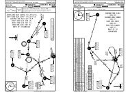
Licensed to Elefant air. Printed on 15 Jul 2009.Notice: After 17 Jul 2009 0901Z, this chart may no longer be valid. Disc 13-2009LPMA/FNC32-4232-41.932-41.832-41.732-41.616-46.8STAND No.A1A2, A3A4 thru A7A8A9 thru A12CBreakawayarea16-46.7A19A1JEPPESEN24 APR 09 10-9A .Eff.7.May.RWY 05/23A3A2A4A516-46.6A6INS COORDINATESCOORDINATES STAND No.AA7A816-46.5 16-46.4TERMINALBAPRON AJEPPESENJeppView 3.6.3.032-41.832-41.732-41.632-41.516-46.8 16-46.6 16-46.516-46.4 16-46.3N32 41.5 W016 46.7N32 41.6 W016 46.7N32 41.6 W016 46.6N32 41.6 W016 46.5N32 41.7 W016 46.5A9META11A10A12Control TowerA13 thru A15A16 thru A18A19A18A16A15A14A13BreakawayareaA17COORDINATES32-4232-41.9N32 41.7 W016 46.4N32 41.8 W016 46.4N32 41.6 W016 46.7PUSH-BACK, START-UP AND TAXI PROCEDURESJet acft engine start-up is only permitted after push-back manoeuvre with acftpositioned in breakaway area.All acft must activate anti-collision lights before starting engines.To prevent blast damage in acft equipment and personnel, all acft operations onthe apron must be made using lowest power setting.CHANGES: None.Marshaller assistance compulsory.Stand entrance is only allowedwith follow-me.Jet widebody aircraft with awingspan of above 194'/59mshall stop facing to the North.ARPMADEIRA, MADEIRA ISMADEIRA| JEPPESEN, 2000, 2007. ALL RIGHTS RESERVED.BRIEFING STRIP TMPANS OPS 4Licensed to Elefant air. Printed on 15 Jul 2009.Notice: After 17 Jul 2009 0901Z, this chart may no longer be valid. Disc 13-2009LPMA/FNCJEPPESEN24 APR 09MADEIRA 13-1 1124.4 119.2VORFinal Minimum AltMDA(H) Apt Elev 192'<strong>FUN</strong>Apch Crs D7.0112.2 212^ 3000' (2853')940' (793')RWY 147'MISSED APCH: Turn LEFT onto heading 139^ to intercept R-172, proceedto FUSUL climbing to 3000' and hold. Contact APP.Alt Set: hPa32-5030006000{ 6110'5000100040003000ATIS3000RWY 05147'1000CHANGES: Minimums.200040002000Rwy Elev: 5 hPa10002034'.Eff.7.May.MADEIRA Approach10002041'Trans level: By ATC172^016^ CAT C & D020^ CAT A & B4JEPPESENJeppView 3.6.3.0MADEIRA, MADEIRA ISCIRCLING VOR DME Rwy 05MADEIRA Tower118.35(IF)D12.0D12.0MHA3000CAT C & DCAT A & B016^020^(IAF)<strong>FUN</strong>CHALDF U NABUSUD7.0D8.0Gnd speed-Kts 70 90 100 120 140 160HIALSDescent angle 2.12^ 262 337 375 450 525 600 PAPI PAPIMAP at D3.605..CEILING.REQUIRED..Not authorized Northwest of rwyMaxKts MDA(H)CEIL-VISABC100135800'180 940'(793')- 5000m245mTrans alt: 5000'32-4016-5016-40<strong>FUN</strong> DME 1.0 2.0 3.0 4.0 5.0 6.0ALTITUDE 1650' 1880' 2100' 2330' 2550' 2760'D 2051 FOR VOR VISUAL APPROACH PATTERNTO RWY 05 SEE 13-1A.VOR2 4000'2 5000'via STAR MADAT 3AD3.6.Standard.<strong>FUN</strong> DME required.CAUTION: Execute all turnsover the sea due to high terrainto the North and West of apt.CIRCLE-TO-LANDTO RWY3.6212^1430'212^139^ hdgD3.63032^212^DESERTA ISup to 1571'14 NM ESEfrom apt.212^(IAF)ABUSUD7.0D8.0112.2 <strong>FUN</strong>3000'032^7.0 1.0 4.0139^hdgLTWind limitations forlanding (relative to thetouchdown anemometertwo minutes meanvalues only): maxpermissible wind.Relative to theMID or Rosarioanemometersincluding gust.300^MISSED APCHFIX230^<strong>FUN</strong>112.2R-17215KT25KTgusts425KT200^MSA<strong>FUN</strong> VORD12.0212^30KT20KTgusts316-30Startturn atA & B:3 MinC & D:2 Min3000'FUSUL120^| JEPPESEN, 2000, 2009. ALL RIGHTS RESERVED.172^146^8200'026^3000172^20KT30KTFUSULD9.0gusts352^010^ 020^190^3500'7.03000'040^
Licensed to Elefant air. Printed on 15 Jul 2009.Notice: After 17 Jul 2009 0901Z, this chart may no longer be valid. Disc 13-2009BRIEFING STRIP TM540 12 3LPMA/FNCMADEIRAATIS124.4VOR32-4510001000Alt Set: hPa32-402566'2000804'998'1913'722'870'15001168'<strong>FUN</strong>112.22221'10002014'1821'5001.1 NM1500Curved LDINsystemJEPPESEN24 APR 0913-1A.Eff.7.May.1634'1487'1460'1063'378'ROSARIOat 460'(313')GELOat 850'2.3 NM371'(703')2030'2041'1933'1000853'PAPI (Both sides offset 5^ to the Right. Right side notvisible on short final) should be followed. They are setto define a 3.0^ descent path crossing the thresh at 57'.D6.05001140'940'MAPD3.6JEPPESENJeppView 3.6.3.0MADEIRA, MADEIRA ISVOR VISUAL APPROACH Rwy 05MADEIRA Approach119.2FinalApch Crs212^466'By night the rwy 05 approach lightsIf those lights fail before the aircraft is in such aposition, over those lights, that will ensure that thehigh ground on their left side will be avoided, amissed approach (RIGHT turn) should be initiated.Rwy slope is 0.8-1% up.Due to high terrain CAUTION should be exercisednot flying left of approach light path.1483'1129'801'1.6 NM1140'940'1(993')RECOMMENDED(793')MINIMUMMADEIRA Tower118.35Apt Elev522'212^(993')(793')192'RWY 147'RECOMMENDEDMINIMUMQFE values relatedto thresh 0516-45MISSED APCH: Turn RIGHT onto heading 139^ to intercept R-172, proceed toFUSUL climbing to 3000' and hold. Contact APP.MUST BE ON.CHANGES: Missed apch.Rwy Elev: 5 hPa Trans level: By ATCTrans alt: 5000'DF<strong>FUN</strong>CHAL112.2 U <strong>FUN</strong> NWind limitations forlanding (relative to thetouchdown anemometertwo minutes meanvalues only): maxpermissible wind.Relative to theMID or Rosarioanemometersincluding gust.Recommended190 KT300^230^139^ hdgMISSED APCHFIX172^15KT25KTgusts125KT200^010^ 020^30KT190^20KTgusts20KT30KTgusts040^12 0 ^| JEPPESEN, 2000, 2009. ALL RIGHTS RESERVED.3000172^FUSULD9.0/R-172352^BRIEFING STRIP TMPANS OPS 4Licensed to Elefant air. Printed on 15 Jul 2009.Notice: After 17 Jul 2009 0901Z, this chart may no longer be valid. Disc 13-2009LPMA/FNCJEPPESEN24 APR 09MADEIRA 13-232-5032-406000{6110'5000ATIS124.4VOR<strong>FUN</strong>112.2Alt Set: hPa1000<strong>FUN</strong> DMEALTITUDE400030003000FinalApch Crs20004000212^2000MADEIRA Approach119.2Minimum AltD7.03000'1000VOR14000'1 5000'via STAR MADAT 3A(2808')1300'(1108')016^020^ CAT A & BJEPPESENJeppView 3.6.3.0MADEIRA, MADEIRA ISCIRCLING VOR DME Rwy 23MADEIRA Tower118.35MDA(H) Apt Elev 192'CAT C & DRWY 192'Rwy Elev: 7 hPa Trans level: By ATC Trans alt: 5000'16-502034'.Eff.7.May.MISSED APCH (IFR/VFR): Turn LEFT onto heading 139^ to intercept R-172,proceed to FUSUL climbing to 3000' and hold. Contact APP.In order to never cross to the North (RIGHT) ofR-237 (or 236^ from NDB):-On the visual apch, initiated overhead VOR, theacft should be kept slightly LEFT of this radial untila point where, with TDZ and PAPI in sight, it hasto line up with the rwy.-Maintain MDA(H) until intercepting the 3.00^ finaldescent path defined by the PAPI, which crossesthe thresh at 57'.-During the apch do not deviate to the North (RIGHT)of the extended CL of rwy 23 due to high terrain.-At night the hills on your RIGHT may be confusedwith mist. This obstacle is lighted.-Touchdown rwy 23 out of Control Tower visual range.-TDZ lighting is provided.-A go around manoeuvre should be performed if theacft has not landed by the end of these lights.RWY 23192'CHANGES: Missed apch. Minimums.<strong>FUN</strong>CHALM 318 A MADD2041'MHA3000CAT C & DCAT A & B016^020^D12.016-40ABUSUD8.0D7.01.0 2.0 3.0 4.0 5.0 6.01550' 1800' 2050' 2300' 2550' 2800'237^VFR139^hdg237^3.9139^hdg172^2212^032^DESERTA ISup to 1571'14 NM ESEfrom apt.212^(IAF)3000'032^ABUSUD7.0 D8.0300^D12.0230^(IF)4200^146^8200'026^MISSED APCHFIXD12.0212^15KT25KTgusts30KT3500'MSA<strong>FUN</strong> VORCAUTION: Execute all turnsover the sea due to highterrain to the North andWest of apt.7.03000'20KTgusts3216-30FUSULD9.0Startturn atA & B:3 MinC & D:2 Min7.0 1.0 4.00 3.9TO DISPLACED THRESHOLDGnd speed-Kts 70 90 100 120 140 160ALS139^ <strong>FUN</strong> 3000'Descent angle 2.29^ 283 364 405 486 567 648PAPIhdg 112.2 FUSULMAP at D3.6R-172LT.Standard. CIRCLE-TO-LAND .CEILING.REQUIRED. Wind limitations for landingTO RWY 23(relative to the touchdownNot authorized Northwest of rwy anemometer two minutesMaxmean values only): maxKtsMDA(H)CEIL-VISA 100permissible wind.B 135C 180 1300' (1108')1200' - 7000m 3 Relative to the MID370manemometer.D 2054 Relative to the MID orRosario anemometersincluding gust.IFRDF(IAF)<strong>FUN</strong>CHALU N112.2 <strong>FUN</strong>25KT1 2 0 ^| JEPPESEN, 2000, 2009. ALL RIGHTS RESERVED.172^3000172^010^ 020^190^15KTgusts352^25KT040^
PANS OPS 4Licensed to Elefant air. Printed on 15 Jul 2009.Notice: After 17 Jul 2009 0901Z, this chart may no longer be valid. Disc 13-2009BRIEFING STRIP TMLPMA/FNC3000600050001000400030003000100020004000200010001000Gnd speed-Kts 70 90 100 120 140 160NDB to MAP 3.2 2:45 2:08 1:55 1:36 1:22 1:12JEPPESENJeppView 3.6.3.0MADEIRA, MADEIRA IS5 JUN 09 1 CIRCLING NDB Rwy 05JEPPESENMADEIRA 16-1ATISMADEIRA ApproachMADEIRA Tower124.4119.2118.35NDBFinal Minimum AltMDA(H) Apt Elev 192'MAD Apch Crs NDB318 200^ 1430' (1283')940'(793')RWY 147'MISSED APCH: Climb on 200^ from NDB to 4500', then turn LEFT to NDBclimbing to 5000' and hold.Alt Set: hPa32-50{6110'32-401 FOR NDB VISUAL APPROACH PATTERNTO RWY 05 SEE 16-1A.RWY 05147'.Standard.052034'16-50CHANGES: Procedure designation.(IAF)<strong>FUN</strong>CHALM 318 A MAD D2041'NDB5000'020^3.2 to MAP200^1430'..CEILING.REQUIRED..Not authorized Northwest of rwyMaxKts MDA(H)CEIL-VISA 100BC135800'180 940'(793')- 5000m245mD 205Rwy Elev: 5 hPaCIRCLE-TO-LANDTO RWYCAUTION: Execute all turnsover the sea due to high terrainto the North and West of apt.Trans level: By ATC200^200^2020^16-40MHA5000DESERTA ISup to 1571'14 NM ESEfrom apt.200^Trans alt: 5000'PAPIWind limitations forlanding (relative to thetouchdown anemometertwo minutes meanvalues only): maxpermissible wind.3200'HIALS300^PAPI230^4500'on2200^CAT A & B:3 MinCAT C & D:2 Min15KT25KTgustsMSAMAD NDB010^ 020^30KT20KTgusts20KT16-30200^fromMAD31812 0^Relative to theMID or Rosarioanemometersincluding gust.| JEPPESEN, 2000, 2009. ALL RIGHTS RESERVED.25KT146^8200'026^190^gusts30KT3500'040^BRIEFING STRIP TM540 12 3Licensed to Elefant air. Printed on 15 Jul 2009.Notice: After 17 Jul 2009 0901Z, this chart may no longer be valid. Disc 13-2009LPMA/FNCMADEIRA10001000Alt Set: hPa32-4532-402566'2000804'1913'998'722'870'124.4NDBMAD15001168'ATIS3182221'100050015002014' 1634'1821'Curved LDINsystemJEPPESEN5 JUN 09 16-1A1487'1460'1063'378'ROSARIOat 460'1.1 NMGELOat 850'371'(313')(703')2030'2041'1933'1000853'By night the rwy 05 approach lightsIf those lights fail before the aircraft is in such aposition, over those lights, that will ensure that thehigh ground on their left side will be avoided, amissed approach (RIGHT turn) should be initiated.PAPI (Both sides offset 5^ to the Right. Right side notvisible on short final) should be followed. They are setto define a 3.0^ descent path crossing the thresh at 57'.Rwy slope is 0.8-1% up.Due to high terrain CAUTION should be exercisednot flying left of approach light path.500JEPPESENJeppView 3.6.3.0MADEIRA, MADEIRA ISNDB VISUAL APPROACH Rwy 05MADEIRA Approach119.2FinalApch Crs200^466'1483'1129'801'12.3 NMQFE values relatedto thresh 05(993')(793')MADEIRA Tower118.35Apt Elev 192'522'1140'940'RECOMMENDEDMINIMUMRWY 147'<strong>FUN</strong>CHALM 318 A MAD DRecommended 190 KTMAP 3.2 NMFROM MAD NDB237^230^200^1200^(993')(793')940' MINIMUM1140' RECOMMENDEDMISSED APCH: Turn RIGHT onto heading 139^ climbing to 5000', then turn LEFT to NDBand hold. Contact APP.MUST BE ON.CHANGES: Procedure designation.Rwy Elev: 5 hPa Trans level: By ATCTrans alt: 5000'16-45139^ hdgWind limitations forlanding (relative to thetouchdown anemometertwo minutes meanvalues only): maxpermissible wind.Relative to theMID or Rosarioanemometersincluding gust.300^MISSED APCH HOLDINGMAD NDB25KT200^500015KT25KTgusts30KT020^010^ 020^20KTgusts20KT190^gusts30KT040^120^| JEPPESEN, 2000, 2009. ALL RIGHTS RESERVED.
Licensed to Elefant air. Printed on 15 Jul 2009.Notice: After 17 Jul 2009 0901Z, this chart may no longer be valid. Disc 13-2009BRIEFING STRIP TMLPMA/FNCJEPPESEN5 JUN 09MADEIRA 16-2NDBMAD318ATIS124.4FinalApch Crs200^Minimum AltNo FAFMADEIRA Approach119.2JEPPESENJeppView 3.6.3.0MADEIRA, MADEIRA ISCIRCLING NDB Rwy 23MDA(H) Apt Elev 192'1300'(1108')RWY 192'MISSED APCH: IFR: Climb on 200^ from NDB to 4500', then turn LEFT toNDB climbing to 5000' and hold. VFR: Turn LEFT onto heading 139^climbing to 5000', then turn LEFT to NDB and hold. Contact APP.Alt Set: hPaRwy Elev: 7 hPa Trans level: By ATCTrans alt: 5000'MADEIRA Tower118.35In order to never cross to the North (RIGHT) of R-237 (or 236^ from NDB):-On the visual apch, initiated overhead VOR, the acft should be kept slightly LEFT of this radial untila point where, with TDZ and PAPI in sight, it has to line up with the rwy.-Maintain MDA(H) until intercepting the 3.00^ final descent path defined by the PAPI, which crossesthe thresh at 57'.-During the apch do not deviate to the North (RIGHT) of the extended CL of rwy 23 due to high terrain.-At night the hills on your RIGHT may be confused with mist. This obstacle is lighted.-Touchdown rwy 23 out of Control Tower visual range.-TDZ lighting is provided.-A go around manoeuvre should be performed if the acft has not landed by the end of these lights.146^8200'026^3500'MSA MAD NDB32-50CAUTION: Execute all turnsover the sea due to high terrainto the North and West of apt.200^2034'MHA5000PANS OPS 432-406000{6110'50001000400030003000RWY 23192'20004000200016-50236^10000 3.9CHANGES: Chart reindexed. Procedure designation.2041'NDB5000'MAP at NDB.Standard. CIRCLE-TO-LANDTO RWY 23Not authorized Northwest of rwyMaxKtsMDA(H)CEIL-VISABC1001351801200'1300' (1108')- 7000m370mD 205VFR139^hdg236^020^.CEILING.REQUIRED.3.9IFR12200^020^<strong>FUN</strong>CHALDF 112.2 U <strong>FUN</strong>N(IAF)<strong>FUN</strong>CHALM 318 A MAD DDESERTA ISup to 1571'14 NM ESEfrom apt.16-40200^3200'Wind limitations for landing(relative to the touchdownanemometer two minutesmean values only): maxpermissible wind.PAPI230^CAT A & B:3 MinCAT C & D:2 MinALS2200^116-30TO DISPLACED THRESHOLD300^Relative to the MIDanemometer.Relative to the MID or Rosarioanemometers including gust.25KT15KT25KTgustsRefer toMissed Apchabove010^ 020^30KT20KTgusts15KT190^gusts25KT040^120^| JEPPESEN, 2000, 2009. ALL RIGHTS RESERVED.