physical setting earth science
physical setting earth science
physical setting earth science

Create successful ePaper yourself
Turn your PDF publications into a flip-book with our unique Google optimized e-Paper software.
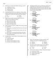
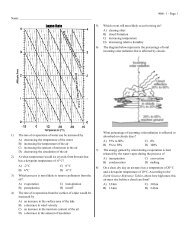
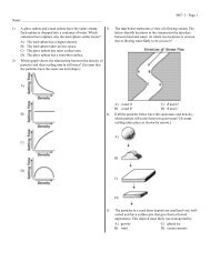
Part B–1Answer all questions in this part.Directions (36–50): For each statement or question, write on your separate answer sheet the number of theword or expression that, of those given, best completes the statement or answers the question. Some questionsmay require the use of the Earth Science Reference Tables.Base your answers to questions 36 through 38 on the weather map below and on your knowledge of Earth<strong>science</strong>. The weather map shows a typical low-pressure system and associated weather fronts labeled A and B.The L indicates the center of the low-pressure system. A few New York State cities are shown. Symbols cP andmT represent different air masses. The wind direction at Utica and Rochester is shown on the station models.PlattsburghcPRochesterBuffaloJamestownALOswegomTIthacaUticaBcPN36 Which front symbols are drawn correctly, based on the air masses shown?LLLLA( 1 )BA( 2 )BA( 3 )BA( 4 )B37 If this weather system is following a normal storm track, the center of this low is mostlikely moving toward which city?(1) Buffalo (3) Utica(2) Ithaca (4) PlattsburghP.S./E. Sci.–Jan. ’06 [10]