06_formations_surfex_ecoclimap_fin
06_formations_surfex_ecoclimap_fin 06_formations_surfex_ecoclimap_fin
PlanECOCLIMAP: principleTechnical aspects in SURFEXECOCLIMAP IECOCLIMAP II EuropeECOCLIMAP II Africa
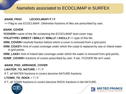
Namelists associated to ECOCLIMAP in SURFEX&NAM_FRACLECOCLIMAP=T / F=> Flag to use ECOCLIMAP. Otherwise fractions of tiles are prescribed by user.&NAM_COVERYCOVER= name of the file containing the ECOCLIMAP land cover map.YFILETYPE= DIRECT / BINLLV / BINLLF / ASCLLV => type of this file.XRM_COVER= treshold fraction before which a cover is removed from a grid point.XRM_COAST= limit of coast coverage under which the coast is replaced by sea or inland waterin grid points.XRM_LAKE= limit of inland lake coverage under which the water is removed from grid points.XUNIF_COVER= fractions of covers prescribed by user. If set, YCOVER file isn’t used.&NAM_PGD_ARRANGE_COVERLWATER_TO_NATURE = T / FIf T, all WATER fractions in covers become NATURE fractions.LTOWN_TO_ROCK = T / FIf T, all TOWN fractions in covers become ROCK fractions in tile NATURE.
- Page 1 and 2: ECOCLIMAPSurfex Course14-16 october
- Page 3 and 4: A global database of surface parame
- Page 5 and 6: Description of covers in ECOCLIMAP:
- Page 7 and 8: Composition of 1 covernatural param
- Page 9 and 10: Definition of root and total soil d
- Page 11 and 12: Definition of town parameters at co
- Page 13 and 14: NATURE parameters defined at functi
- Page 15 and 16: Grouping of functional types in pat
- Page 17 and 18: Parameters aggregation processlinke
- Page 19: Parameters aggregation processlinke
- Page 23 and 24: Other useful namelistsinputs / outp
- Page 25 and 26: ECOCLIMAP files format ECOCLIMAP fi
- Page 27 and 28: PlanECOCLIMAP: principleTechnical a
- Page 29 and 30: PlanECOCLIMAP: principleTechnical a
- Page 32 and 33: ECOCLIMAP II Europe:Definition of f
- Page 34 and 35: ECOCLIMAP I : the map on Europe
- Page 36 and 37: ECOCLIMAP II simplified map LegendL
- Page 38 and 39: ECOCLIMAP IComparison of C4 fractio
- Page 40 and 41: Comparison of irrigated crops fract
- Page 42 and 43: ECOCLIMAP II AfricaECOCLIMAP II Afr
- Page 44 and 45: 44ECOCLIMAP II Africa - 37 classes
- Page 46 and 47: ECOCLIMAP II Africa - Soil albedoVi
- Page 48 and 49: ECOCLIMAP II Africa - LCM-I with 90
- Page 50 and 51: 50ECOCLIMAP-II Africa- EvaluationGL
- Page 52: 52FIN
Namelists associated to ECOCLIMAP in SURFEX&NAM_FRACLECOCLIMAP=T / F=> Flag to use ECOCLIMAP. Otherwise fractions of tiles are prescribed by user.&NAM_COVERYCOVER= name of the file containing the ECOCLIMAP land cover map.YFILETYPE= DIRECT / BINLLV / BINLLF / ASCLLV => type of this file.XRM_COVER= treshold fraction before which a cover is removed from a grid point.XRM_COAST= limit of coast coverage under which the coast is replaced by sea or inland waterin grid points.XRM_LAKE= limit of inland lake coverage under which the water is removed from grid points.XUNIF_COVER= fractions of covers prescribed by user. If set, YCOVER file isn’t used.&NAM_PGD_ARRANGE_COVERLWATER_TO_NATURE = T / FIf T, all WATER fractions in covers become NATURE fractions.LTOWN_TO_ROCK = T / FIf T, all TOWN fractions in covers become ROCK fractions in tile NATURE.


