EIA Report - Pollution Control Board, Assam
EIA Report - Pollution Control Board, Assam
EIA Report - Pollution Control Board, Assam

You also want an ePaper? Increase the reach of your titles
YUMPU automatically turns print PDFs into web optimized ePapers that Google loves.
Environmental Impact Assessment for Oil Exploration in AA-ONN-2002/3 Block, <strong>Assam</strong>Draft <strong>EIA</strong> <strong>Report</strong>Asian Consulting Engineers Private Limited, New DelhiAugust 2012
<strong>EIA</strong> study for Oil Exploration inAA-ONN-2002/3 Block, <strong>Assam</strong>TABLE OF CONTENTSCHAPTER-1: INTRODUCTION1.1 Prologue ……………………………………………………………………….... 1-11.2 Project Proponent – Oil India Limited (OIL)…………………………………… 1-11.3 Location of the project…………………………………………………………... 1-11.4 Legal And Other Requirement………………………………………………….... 1-21.5 Purpose of the Study……………………………………………………………... 1-31.6 Scope of <strong>EIA</strong> Study……………………………………………………………… 1-41.7 Approach and Methodology……………………………………………………… 1-51.7.1 Establishment Of Baseline Environmental Status………………………… 1-51.7.2 Field Study/monitoring for Generation of Primary Data……………….. 1-51.7.3 Environmental Impact Assessment……………………………………….. 1-51.7.4 Preparation of Environmental management plan…………………………. 1-61.7.5 Preparation of Risk Assessment and Disaster Management Plan……… 1-61.8 Approved TOR for <strong>EIA</strong> Study from MoEF………………………………. 1-61.9 Structure of the <strong>Report</strong>…………………………………………………... 1-9CHAPTER-2: PROJECT DESCRIPTION2.1 Key Block Information………………………………………………………...... 2-12.2 Exploration Objectives………………………………………………..... 2-12.3 Project benefit…………………………………………………………………… 2-12.4 Project location………………………………………………………………….. 2-22.5 Regional Geological Setting…………………………………………...... 2-32.6 Prior To Drilling………………………………………………………………… 2-32.6.1 Site Survey……………………………………………………. 2-42.6.2 Road and site Construction…………………………………… 2-42.7 The Appraisal Drilling Operation 2-42.7.1 Component Of Drilling Rig………………………………….. 2-42.7.2 Well Construction……………………………………………... 2-72.7.3 Drilling fluids…………………………………………………. 2-82.7.4 Cementing program…………………………………………. 2-102.7.5 Well Evaluation……………………………………………… 2-102.7.6 Completion of Drilling……………………………………… 2-112.7.7 Rig Demobilization…………………………………………… 2-112.7.8 Restoration And Rehabilitation………………………………. 2-112.7.9 Staffing……………………………………………………….. 2-122.7.10 Supplies during well drilling………………………………… 2-122.7.11 Waste Stream…........................................................................ 2-132.7.12 Noise, Air Emissions 2-142.7.13 Total Project Cost……………………………………………… 2-15CHAPTER-3: THE EXISTING ENVIRONMENT3.1 Introduction……………………………………………………………………… 3-13.2 Site Description and Its Environs……………………………………………… 3-13.3 State of the Environment (Regional)……………………………………. 3-23.3.1 Topography & Geology………………………………………………… 3-23.3.2 Stratigraphy………………………………………………………. 3-33.3.3 Climate…………………………………………………………… 3-53.3.4 Seismic Considerations…………………………………………... 3-63.4 State of the Environment (Local)………………………………………………. 3-9Asian Consulting Engineers Pvt. Ltd.i
<strong>EIA</strong> study for Oil Exploration inAA-ONN-2002/3 Block, <strong>Assam</strong>3.4.1 Micro-Meteorology………………………………………………. 3-93.4.2 Topography…………………………………………………………….. 3-103.4.3 Land use………………………………………………………………… 3-113.4.4 Soil Characteristic…………………………………………………………. 3-133.4.5 Water Environment……………………………………………………… 3-163.4.5.1 Monitoring Results…………………………………………….. 3-193.4.6 Air Environment………………………………………………………… 3-203.4.6.1 Parameters, Frequency and Monitoring Methodology………. 3-203.4.6.2 Monitoring Result…………………………………………….. 3-203.4.6.3 Ambient Air Quality in the Study Area………………………. 3-203.4.7 Noise Environment……………………………………………………… 3-233.4.7.1 Ambient Noise Monitoring…………………………………… 3-233.4.7.2 Analysis of the Data…………………………………………… 3-263.4.8 Biological Environment…………………………………………………. 3-263.4.9 Socio Economic Environment…………………………………………... 3-393.4.9.1 Demography…………………………………………………… 3-413.4.9.2 Resettelement And Rehabilitation Plan……………………….. 3-46CHAPTER-4 ASSESSMENT OF IMPACTS4.1 Assessment of Impact on the Environment……………………………………… 4-14.2 Identification Of Interactions……………………………………………………… 4-14.3 The Major Activities that may have Impact on Environment…………………… 4-24.4 Assessment of Impacts and <strong>Control</strong> Measures…………………………………. 4-34.4.1 Physical Presence…………………………………………………………. 4-34.4.2 Noise And Vibration……………………………………………………… 4-34.4.3 Air Environment…………………………………………………………. 4-44.4.4 Water Environment……………………………………………………… 4-64.4.5 Solid and Hazardous Waste Impacts……………………………… 4-74.4.6 Biological Environment…………………………………………. 4-84.4.7 Socio-Economic Environment……………………………………. 4-8CHAPTER-5: ENVIRONMENTAL MONITORING PLAN5.1 Introduction ……………………………………………………………………. 5-1CHAPTER-6: DISASTER MANAGEMENT PLAN6.1 Introduction ……………………………………………………………………. 6-16.2 Risk Assessment………………………………………………………… 6-16.2.1 Risk Screening Approach…………………………………………………… 6-26.2.2 Identification of Hazards in Drilling and Production testing operations…… 6-36.2.2.1 Minor oil spill………………………………………………………. 6-36.2.2.2 Major oil spill………………………………………………………. 6-36.2.2.3 Blowout…………………………………………………………….. 6-36.2.2.4 Hydrogen Sulphide…………………………………………………. 6-46.2.3 “Block AA-ONN-2002/03” Oil Exploration Project..................................... 6-46.2.4 QRA Approach…………………………………………………………….. 6-56.2.4.1 Damage due to explosion……………………………………………. 6-66.2.4.2 Thermal Incidents/Fire in Storage Area…………………………… 6-66.3 Mitigation measures………………………………………………….... 6-76.3.1 <strong>Control</strong> Measures For Major Hazards……………………………………….. 6-76.3.1.1 Blowouts…………………………………………………………… 6-86.3.1.2 <strong>Control</strong> measures for H 2 S during drilling…………………………. 6-86.3.1.3 Fire Fighting Facility………………………………………………. 6-10Asian Consulting Engineers Pvt. Ltd.ii
<strong>EIA</strong> study for Oil Exploration inAA-ONN-2002/3 Block, <strong>Assam</strong>6.3.2 Frequency of Occurrence of Accident Scenario…………………………… 6-106.4 Conclusion……………………………………………………………………….. 6-116.5 Disaster Management Plan………………………………………………………. 6-116.5.1 Introduction………………………………………………………………… 6-116.5.2 Emergency classification…………………………………………………… 6-126.5.3 Methodology of DMP Preparation…………………………………………. 6-126.5.4 Emergency Response Group……………………………………………….. 6-136.5.4.1 Emergency Response Centers……………………………………… 6-136.6 On-Site Disaster Management Plan……………………………………………… 6-136.6.1 Site Main <strong>Control</strong>ler……………………………………………………….. 6-136.6.2 The Site Incident <strong>Control</strong>ler Team………………………………………… 6-146.6.3 The Auxiliary Team……………………………………………………….. 6-146.6.4 Responsibilities of Site Main <strong>Control</strong>ler (SMC)………………………….. 6-146.6.5 Responsibilities of Site Incident <strong>Control</strong>ler (SIC at Drilling rig)………….. 6-146.6.6 Responsibilities of Auxiliary Team <strong>Control</strong>ler (ATC)…………………….. 6-156.6.7 Responsibilities of SIC Supervisors…………………………………………. 6-156.6.8 Responsibilities of ATC Supervisors………………………………………. 6-156.6.9 Warning System…………………………………………………………….. 6-156.6.10 Emergency Pan Initiation…………………………………………………. 6-166.7 Emergency Procedures……………………………………………………………. 6-166.7.1 Level 1 Emergencies……………………………………………………….. 6-166.7.2 Level 2 Emergencies……………………………………………………….. 6-166.7.3 Level 3 Emergencies……………………………………………………….. 6-166.7.4 Accident Site Clean Up……………………………………………………. 6-166.7.5 Emergency Response Personal Safety……………………………………… 6-166.7.6 All clear Signal and Public Statement……………………………………… 6-16CHAPTER-7: ENVIRONMENTAL MANAGEMENT PLAN7.1 Purpose and Objectives of the Environmental Management Plan…..................... 7-17.1.1 HSE Policy of Block Operator………………………………………….. 7-17.1.2 Organizational Structure and Responsibilities…………………………... 7-27.1.3 Management Approach…………………………………………………. 7-27.1.4 Organizational Responsibilities…………………………………………. 7-27.1.4.1 Primary Responsibilities…………………………………….. 7-27.1.4.2 Field Management and Quality <strong>Control</strong>……………………….. 7-27.1.4.3 On-the-job Supervision and Monitoring ……………………. 7-27.2 Mitigation Plan………………………………………………………………… 7-37.3 Environmental Training………………………………………………………… 7-77.4 Waste Management Plan………………………………………………………… 7-87.5 Restoration And Rehabilitation………………………………………………….. 7-127.5.1 Well Abandonment……………………………………………………… 7-127.5.2 Well Suspension…………………………………………………………. 7-12Asian Consulting Engineers Pvt. Ltd.iii
<strong>EIA</strong> study for Oil Exploration inAA-ONN-2002/3 Block, <strong>Assam</strong>LIST OF TABLESTable No. Table Title Page No.1.1 Applicable Acts and Guideline .............………...................................................... 1-21.2 TOR Compliance Status……………………………………………………….. 1-62.1 Co-ordinates of the block ………………………………...………………….. 2-23.1 Stratigraphy of <strong>Assam</strong>- Arakan Basin……………………………………………. 3-43.2 Major Earthquakes Recorded…………………………………………………… 3-73.3 Land distribution of the study area………………………………………………. 3-113.4 Analysis Results of soil sampling………………………………………………… 3-153.5 Location of the Sampling Stations for Surface water & Ground water ………… 3-183.6 Surface Water Quality in the Study Area…………………………………….. 3-183.7 Ground Water Quality in the study area………………………………………. 3-193.8 Summary of PM 10 Levels Monitored in the Study Area........................................ 3-213.9 Summary of PM 2.5 Levels Monitored in the Study Area 3-213.10 Summary of SO 2 Levels Monitored in the Study Area........................................... 3-213.11 Summary of NO x Levels in the Study Area............................................................. 3-223.12 Summary of HC Levels in the study Area………………………………………. 3-223.13 Summary of VOC Levels in the study Area……………………………………… 3-233.14 Location of Noise Monitoring Stations.................................................................. 3-233.15 Summary of Ambient Noise Levels Monitored in the Study Area....................... 3-243.16 Noise level at proposed drill locations……………………………………………. 3-253.17 Flora Existing within the Study Area …………………………………….. 3-263.18 List of eco-sensitive area…………………………………………………. 3-313.19 Fauna Species Existing within the Study Area …………………………… 3-323.20 List of species reported from study area and their conservation status…… 3-363.21 List of fish fauna found in the study area…………………………………. 3-363.22 Cropping Calendar in the Study Area ………………………………………….. 3-373.23 Villages in the Study Area ……………………………………………………. 3-403.24 Summary of Demographic Profile …………………………………………… 3-413.25 Environmental Concerns…………………………………………………... 3-453.26 Man-Animal Conflict……………………………………………………… 3-454.1 Interactions between Project Operations and Environmental Sensitivities............. 4-24.2 Occupational and Human Exposure Levels............................................................. 4-44.3 Stack & Emissions Characteristic………………………………………………… 4-54.4 Predicted Maximum GLCs ………………………………………… 4-65.1 Recommended Environmental Monitoring Protocol – Pre Drilling Phase ……… 5-15.2 Recommended Environmental Monitoring Protocol - During Drilling Phase…… 5-25.36.16.26.36.46.56.66.7Recommended Environmental Monitoring Protocol - Post Drilling……………...Co-ordinates of a Block…………………………………………………………...Bulk hazardous chemical storage facility at Drilling site…………………………Risk Classification………………………………………………………………...Damage due to over pressure……………………………………………………..Possible Major Scenarios………………………………………………………….Fire Extinguisher Distribution…………………………………………………….Frequency Occurrence for various accidents scenario……………………………5-36-56-56-56-66-66-106-117.1 Environmental Management Plan - Mitigation Management Matrix (Prior toDrilling Phase)………………………………………………………………….... 7-37.2 Environmental Management Plan - Mitigation Management Matrix (duringDrilling Phase)…………………………………………………………………... 7-47.3 Waste Management Plan………………………………………………………… 7-87.4 Onshore Discharge Standards for Liquid Effluent from oil Drilling…………….. 7-11Asian Consulting Engineers Pvt. Ltd.iv
<strong>EIA</strong> study for Oil Exploration inAA-ONN-2002/3 Block, <strong>Assam</strong>LIST OF FIGURESFigure No. Figure Description Page No.1.1 Location of Block …………………………………………………………….. 1-22.1 Google Image of the Block………………………………………………….... 2-22.2 The Anatomy of Drilling Rig …………………………………………………… 2-52.3 Typical Land Drilling Rig ……………………………………………………… 2-72.4 Typical Drill Fluid Circulation System ………………………………………. 2-93.1 Block Map……………………………………………………………………... 3-13.2 Geological Map of <strong>Assam</strong>……………………………………………………. 3-33.3 Seismic Zoning Map of India ……………………………………………..… 3-63.4 Tectonic faults of <strong>Assam</strong>………………………………………………….. 3-83.5 Satellite Image of the Block………………………………………………. 3-93.6 Windrose Diagram (Winter Season) ………………………………………… 3-103.7 Terrain Map of the Study Area…………………………………………… 3-113.8 Land use distribution in the study area……………………………………. 3-123.9 Land use land cover of the study area……………………………………. 3-133.10 Sampling locations in the study area……………………………………… 3-143.11 Triangular Classification of Soil………………………………………….. 3-163.12 Drainage Map of the study……………………………………………….. 3-173.13 Ambient Noise Levels monitored in the Study Area (Day time)…………. 3-253.14 Ambient Noise Levels monitored in the Study Area (Night time)………... 3-253.15 Location of villages in study area…………………………………………. 3-394.1 Methodology for Environmental Impact Assessment…………………….. 4-16.1 Organizational set up for the On-Site DMP………………………………. 6-14Asian Consulting Engineers Pvt. Ltd.v
<strong>EIA</strong> study for Oil Exploration inAA-ONN-2002/3 Block, <strong>Assam</strong>1INTRODUCTION1.1 PrologueGovernment of India, as per its policy, has given emphasis on Sustainable Development. While it issupporting the industrial growth, the environmental protection has also been made the integratedcriteria for this support. In line with this policy, Ministry of Environment and Forests (MoEF) hasdefined elaborated ‘Environmental Clearance (EC)’ framework under the Environmental ProtectionAct, 1986 (Environmental Impact Assessment Notification, 2006) for establishing/expanding andindustry/ development project. The EC process takes into consideration local conditions, publicconcerns, effectiveness of impact assessment and proposed mitigation measures in sustainingenvironmental equilibrium. The Environmental Impact Assessment (<strong>EIA</strong>) report detailing baselineenvironmental conditions, environmental impacts, mitigation measures and environmentalmanagement plan is required to be prepared for start of EC process.M/s Oil India Limited (OIL) is a BSE listed Company which also provides various E&P relatedservices. The company holds mining lease for block AA-ONN-2002/03 in consortium with ONGC forexploration and production under Production Sharing Contracts (PSC) signed with the Government ofIndia. PSC for the block was signed on 6 th April 2004.OIL intends to drill five exploratory and appraisal wells in the field. The block covers an area of 1095sq km. The estimated cost of the proposed project is INR 100 crores.1.2 Project Proponent – Oil India Limited (OIL)Oil India Private Limited was incorporated on February 18, 1959 to expand and develop the newlydiscovered oil fields in the Indian North East. In 1961, it became a joint venture company between theIndian Government and Burmah Oil Company Limited, UK. In 1981, Oil India Limited (OIL) becamea wholly-owned Government of India enterprise. As on today, OIL is a premier Indian NationalNavaratna Oil Company engaged in the business of exploration, development and production of crudeoil and natural gas, transportation of crude oil and production of LPG with its Field Headquarter atDuliajan, <strong>Assam</strong>.The company presently produces around 3.90 MMTPA of crude oil (around 79,000 barrels per day),6.5 MMSCMD of natural gas and 50,000 tonnes of LPG annually. Most of it emanates from the richoil fields of North-eastern part of India.1.3 Location of the ProjectThe block is located in the petroliferous <strong>Assam</strong>-Arakan basin in Karbi Anglong and Dima Hasaodistrict, <strong>Assam</strong>. This basin is one of the broadly explored basins in India with all the activitiesinitiated about six decades ago in <strong>Assam</strong>. The block has an area of 1095 sq. km out of which DimaHasao district constitutes of 84.98% area (930.53 sq km) while Karbi Anglong district constitutes15.02% area (164.47 sq km). It is located 40 km south west of Diphu city (district headquarter ofKarbi Anglong District) and 31 km north east of Haflong city (district headquarter of Dima HasaoDistrict). The Block area encompasses parts of Dhansiri Reserve Forest in the north east direction andLangting Mupa Reserve Forest in the central west direction. Apart from some sporadic houses, fewAsian Consulting Engineers Pvt. Ltd. 1-1
<strong>EIA</strong> study for Oil Exploration inAA-ONN-2002/3 Block, <strong>Assam</strong>jhoom villages, permanent villages and townships exist in the block. Fig 1.1 shows the location of theblock.1.4 Legal and Other RequirementsFig. 1.1: Location of the BlockOIL activities will conform to all National and International legislations, regulations, conventions,etc., relating to aspects of hydrocarbon operations in India.Recognizing the need of environmental safety, operator has established an HSE Policy towardsenvironmental protection. A list of applicable Acts and Rules is described in Table 1.1.Table 1.1: Applicable Acts and GuidelinesIssuesHazardousSubstances& WastesApplicable Legislation1) The Environment (Protection) Act, 1986 and Rules there under -a) Hazardous Wastes (Management, Handling and Trans-boundaryMovement) Rules, 2008 and amendments thereafter;b) Guidelines for disposal of solid wastes by Oil Drilling and GasExtraction industry as notified, vide notification dated GSR 176 (E)April 1996;c) Manufacture Storage and Import of Hazardous Chemicals 1989 andamendments thereafter.2) The Public Liability Insurance Act, 1991 and Rules 1991Asian Consulting Engineers Pvt. Ltd. 1-2
<strong>EIA</strong> study for Oil Exploration inAA-ONN-2002/3 Block, <strong>Assam</strong>IssuesApplicable Legislation3) Central Motor Vehicles Act, 1988 and Rules, 19894) The Petroleum Act, 1934Water 5) The Water (Prevention and <strong>Control</strong> of <strong>Pollution</strong>) Act, 1974, andamendments thereafter6) The Environment Protection Act, 1986 - Standards for liquid dischargeby Oil Drilling and Gas Extraction industry as notified vide notificationdated GSR 176 (E) April 1996.Air 7) The Air (Prevention and <strong>Control</strong> of <strong>Pollution</strong>) Act, 1981 andamendments thereafter.NoiseSafety andProtectionagainst<strong>Pollution</strong> ofEnvironment8) The Environment Protection Act, 1986 – Guidelines for discharge forgaseous emissions by Oil Drilling and Gas Extraction industry asnotified vide notification dated GSR 176 (E) April 19969) The Environment (Protection) Second Amendment Rules, 2002 –Emission Standards for New Generator Sets.10) The Factories Act, 1948 and amendments thereafter.11) The Motor Vehicles Act, 1938 and amendments thereafter.12) The Environment (Protection) Second Amendment Rules, 2002 (NoiseLimits for New Generator Sets).13) The Noise (Regulation & <strong>Control</strong>) Rules, 2000.14) Oil Mines Regulations, 1984.15) Oil Field (Regulation and Development) Act 1948 and The Petroleum& Natural Gas Rules, 1959 and amendments thereafter.The project is also designed so as to abide by the guidelines set out by The Central <strong>Pollution</strong> <strong>Control</strong><strong>Board</strong> (CPCB) and Ministry of Environment & Forests (MoEF) on various environmentalmanagement issues.The <strong>EIA</strong> process has been undertaken to meet the requirements of Ministry of Environment andForests, Government of India.1.5 Purpose of the StudyThe project activities are listed in Serial No. 1(b) of the Schedule of <strong>EIA</strong> Notification, 2006 (OnshoreOil and Gas Exploration, Development & Production). The proposed project is categorized asCategory ‘A’ and needs the environmental clearance from the Ministry of Environment & Forests(MoEF). The area under consideration is covered by the Production Sharing Contract for AA-ONN-2002/03 block signed by OIL with Government of India and for exploration & appraisal drilling offive wells. The well locations have been delineated on the basis of seismic studies carried out in theblock and after due consideration of all alternatives possible.The environmental study undertaken is aimed at identifying existing environmental conditions,predicting environmental impacts associated with the proposed appraisal drilling and suggestingmitigation measures to mitigate the adverse environmental impacts. The different activities that arelikely to take place have been analyzed and proposed mitigation measures are assessed for theiradequacy. Additional mitigation measures have been proposed where considered necessary.Asian Consulting Engineers Pvt. Ltd. 1-3
<strong>EIA</strong> study for Oil Exploration inAA-ONN-2002/3 Block, <strong>Assam</strong>1.6 Scope of <strong>EIA</strong> StudyThe scope of the <strong>EIA</strong> study includes detailed characterization of the existing status of the land, water,air, biological and socio-economic environment in the study area, identification of the potentialenvironmental impacts of the project, and formulation of an effective Environmental ManagementPlan (EMP) to prevent, control & mitigate the adverse environmental impacts, and ensuring theenvironmental compliance. The scope of the <strong>EIA</strong> will also include rapid risk assessment and disastermanagement plan during exploration activities. This report is based on the TOR approved by Ministryof Environment and Forests, government of India vide letter- No. J-11011/342/2010-IA II (I) datedOctober 29, 2010. The <strong>EIA</strong> study includes:1. Project Description and Project Benefits2. Site details including satellite imagery for 10 Km area.3. Land use along with maps & cropping pattern, vegetation Ecology, Flora & Fauna.4. Demography & Socio-economics of the area5. Process details for survey and drilling.6. Baseline data collection for air, water and soil for 5 weeks leaving the monsoon seasonin area of 10 Km radius with centre of Oil Field as its centre covering the area of all theproposed drilling wells. Ambient Air Quality Monitoring at 8 locations for PM 10 , PM 2.5 , SO 2 , NO x . Background levels of hydrocarbons (HC) and VOCs (5 samples) Soil sample analysis at 10 locations Baseline underground and surface water quality in the vicinity of 10 km area Climatology & Meteorology including wind speed, wind direction, temperature,rainfall, etc. Measurement of Noise levels at 10 locations in the block7. Detailed water balance, waste water generation and discharge8. Treatment & utilization of produced water.9. Detailed solid waste generation, collection, segregation, its recycling and reuse,treatment and disposal.10. Estimation and computation of air emissions resulting out of drilling operations.11. Assessment of impact on air, water, soil, solid/hazardous waste and noise levels.12. Evaluation of the adequacy of the proposed pollution control measures to meet the airquality emission standards, water discharge norms, solid/hazardous waste generation anddisposal.13. Estimation of Noise level due to operation of drilling, its associated equipments andvehicular movement & prediction & evaluation of impacts due to increase in noise levelsarising out of the proposed activities on the surrounding environment. Proposedmitigation measures for noise pollution.14. Storage of chemicals at the site, proposed preventive measures for spillage & accident.15. Environmental Management Plan16. Risk Assessment & Disaster Management Plan Identification of hazards Consequence Analysis Risk Presentation & proposed measures for risk reduction Disaster Management Plan(DMP) Oil Spill contingency plan & emergency response plan17. Measures for decommissioning of the rigs & projects.18. Post project closure and monitoring programme for 10 years.Asian Consulting Engineers Pvt. Ltd. 1-4
<strong>EIA</strong> study for Oil Exploration inAA-ONN-2002/3 Block, <strong>Assam</strong>19. Documentary proofs for memberships of common disposal facilities, if any.20. Details of proposed Occupational Health Surveillance program for the employees &other labour.21. Environmental Monitoring program while survey and drilling is undertaken.1.7 Approach & Methodology of <strong>EIA</strong> StudyThe study basically includes establishment of the present environmental scenario within the blockarea. <strong>EIA</strong> report consists of study of the specific activities related to the project and evaluation of theprobable environmental impacts, thus, leading to the recommendations of necessary environmentalcontrol measures. The entire <strong>EIA</strong> study has been carried out on the basis of the applicableenvironmental legislation, regulations and guidelines of MoEF.1.7.1 Establishment of Baseline Environmental StatusA comprehensive database on the baseline environmental status/conditions of the study area has beenestablished through review, compilation & analysis of:Existing published secondary data/ literature/ information collected, andPrimary data generated/ collected through field study, survey and monitoring.1.7.2 Field Study/Monitoring for Generation of Primary DataThe collected secondary data has been appropriately supplemented by conducting the necessaryprimary data generation/ collection through field study/monitoring in one season study period (winterseason). The field monitoring has been carried out as per the guidelines of CPCB & BIS andrequirement of the MoEF. Field study/monitoring has been conducted on:i) Soil Monitoring: To study the soil characteristics in the study area, soil samples fromrepresentative locations in the study area have been collected and analysed for importantrelevant physical & chemical parameters.ii) Water Quality Monitoring: For drawing up the baseline data on water quality, water qualitymonitoring has been conducted at representative locations in the study area. Ground andsurface water samples have been collected and analyzed for important relevant physical andchemical parameters.iii) Ambient Air Quality Monitoring: For drawing up the baseline status of ambient air qualityin the study area, ambient air quality monitoring in respect of PM 10 , SO 2 , NO x , HC and VOChas been conducted at representative locations in the study area adopting a 24-hours schedule.iv) Noise Monitoring: To establish the ambient noise scenario in the study area, monitoring ofambient noise level has been carried out at the representative locations in the study area usinga suitable portable sound level meter over a period of twenty-four hours.1.7.3 Environmental Impact AssessmentThe environmental impact assessment has been conducted in accordance with the norms andguidelines of the Govt. of India. The project data/activities has been analysed & linked with theexisting baseline environmental conditions in order to list out the affected environmental parametersand assess the likely impacts on such parameters. Wherever practicable, a quantitative analysis hasbeen performed. Suitable computer models, wherever applicable, have been used. Compliance of theproject with national standards has been duly checked.Asian Consulting Engineers Pvt. Ltd. 1-5
<strong>EIA</strong> study for Oil Exploration inAA-ONN-2002/3 Block, <strong>Assam</strong>1.7.4 Preparation of Environmental Management PlanEnvironmental Management Plan (EMP) is the key to ensure a safe and clean environment. Thedesired results from the environmental mitigation measures proposed in the project may not beobtained without a management plan in order to assure its proper implementation & function. TheEMP envisages the plans for the proper implementation of mitigation measures to reduce the adverseimpacts arising out of the project activities. EMP has been prepared addressing the issues like:<strong>Pollution</strong> control/mitigation measures for abatement of the undesirable impacts causedduring drilling and other exploration allied activities,Details of management plans (Ground water management plan, Solid waste managementplan, Hazardous waste management plan, Management plan for handling hazardoussubstances like oil, etc.),Institutional set up identified/recommended for implementation of the EMP,Post project environmental monitoring programme to be undertaken.1.7.5 Preparation of Risk Assessment and Disaster Management PlanLocation of emergency spots within the works and their eliminating procedures,Minimize the effects of the disaster on people and property,To plan on-site and offsite emergency procedure,To lay out implementation procedure of the emergency preparedness plans.1.8 Approved TOR for <strong>EIA</strong> Study from MoEFThe application for the Terms of Reference (TOR) approval for the said project had been submitted tothe Ministry of Environment & Forests (MoEF) on 24 th June, 2010. Presentation to the ExpertAppraisal Committee of the MoEF for scoping of the project was made on 16 th - 17 th September,2010. The Expert Appraisal Committee has issued the TOR for the <strong>EIA</strong> study on 29 th October, 2010.The <strong>EIA</strong> study has been conducted in-line with the approved TOR by MOEF and taking intoconsideration the structure of the report given in the <strong>EIA</strong> Notification 2006 and amendmentsthereafter. Compliance to the approved TOR has been presented in Table 1.2.Table 1.2: TOR Compliance StatusS. No. Terms of Reference Status1 Executive summary of the project. Page 12 Details of existing and proposed activities intabulated form including GGSs/CTF/CPF.3 No. of development wells for whichenvironmental clearance is accorded and no. ofnew wells proposed during expansion. Statusand no. of wells which are completed andclosed.4 Point-wise compliance report to the conditionsstipulated in environmental clearance accordedfor the existing project.5 Point-wise compliance report to the ‘Consentto Establish’ ‘Consent to Operate’ andAuthorization for the existing units along withChapter 2, Section 2.1Chapter 2, Section 2.1 & 2.2Not applicable.Not applicable.Asian Consulting Engineers Pvt. Ltd. 1-6
<strong>EIA</strong> study for Oil Exploration inAA-ONN-2002/3 Block, <strong>Assam</strong>all the necessary annexures.6 Project Description and Project Benefits Chapter 2, Section 2.1 to 2.77 Site details including satellite imagery for10km area. Location of National park/ WildlifeSanctuary/ Reserve Forest/ Eco sensitive area.8 Permission from the State Forest Departmentregarding the impact of the proposed plant onthe surrounding National park/WildlifeSanctuary/Reserve Forest/Eco sensitive area, ifany.9 Status of acquisition of land with break-updetails (Govt./Pvt./Forest land etc.) viz. Totalland acquired/ to be acquired for the proposedproject.10 Approval of the forest land to be used in theproject by the concerned department.11 Land use along with maps & cropping pattern,vegetation ecology, flora and faunaAsian Consulting Engineers Pvt. Ltd. 1-7Chapter 3, Section 3.2, 3.3 and 3.4Chapter 3, Section 3.2The proposed well locations are 10kmaway from the National park/WildlifeSanctuary and outside the Reserve Forestarea.The land for the locations will be eitherGovt. or Private land which will beacquired through Govt. agency or law ofthe land. Around 3 Ha of land will berequired for each location apart from theland required for approach road.Not applicable since the well locations areoutside the forest land.Chapter 3, Section 3.4.3 and 3.4.812 Demography and socio-economics of the area. Chapter 3, Section 3.4.913 Process details for survey and drilling. Chapter 2, Section 2.6.1 and 2.714 Approval of the forest land from theState/Central Govt. under Forest(Conservation) Act,198015 Base line data for land subsidencemeasurements should be incorporated. Anyissues related to land subsidence.16 Baseline data collection for air, water and soilfor one season leaving the monsoon season inarea of 10 Km radius with centre of Oil Fieldas its centre covering the area of all theproposed drilling wells.• Action plan to control ambient air qualityas per NAAQS Standards notified by theministry on 16 th September, 2009 at variouslocations.• Ambient Air Quality Monitoring at 8locations for PM 10 , RSPM, SO 2 , NO x.• Background levels of hydrocarbons (HC)and VOCs (5 samples)• Soil sample analysis at 10 locations• Baseline underground and surface waterquality in the vicinity of 10 km area• Climatology & Meteorology includingwind speed, wind direction, temperature,rainfall etc.• Measurement of Noise levels at 10locations in the blockNot applicable. Same as above.Chapter 3, Section 3.4.9Chapter 3, Section 3.4.4 to 3.4.717 ‘Permission’ for the drawl of water from the Same will be obtained if required.
<strong>EIA</strong> study for Oil Exploration inAA-ONN-2002/3 Block, <strong>Assam</strong>Competent Authority. Detailed water balance,wastewater generation and discharge.18 Treatment & utilization of produced water. Chapter 2, Section 2.7.1119 Detailed solid waste generation, collection,segregation, its recycling and reuse, treatmentand disposal.20 Estimation and computation of air emissionsresulting out of drilling operations.21 Assessment of impact on air, water, soil,solid/hazardous waste and noise levels.22 Evaluation of the adequacy of the proposedpollution control measures to meet the airquality emission standards, water dischargenorms, solid/hazardous waste generation anddisposal.23 Estimation of Noise level due to operation ofdrilling, its associated equipments andvehicular movement & prediction &evaluation of impacts due to increase in noiselevels arising out of the proposed activities onthe surrounding environment. Proposedmitigation measures for noise pollution.24 Storage of chemicals at the site, proposedpreventive measures for spillage & accident.25 Environmental Management Plan Chapter 726 Risk Assessment & Disaster Management Plan Identification of hazards Consequence Analysis Risk Presentation & proposed mitigationmeasures for Risk Reduction Disaster Management Plan(DMP) Design details of Blowout Preventer (BOP)and how it works Oil Spill contingency plan & EmergencyResponse Plan27 Measures for decommissioning of the rigs &projects.28 Post project closure and monitoringprogramme.29 Documentary proofs for memberships ofcommon disposal facilities, if any.30 Details of proposed Occupational HealthSurveillance program for the employees &other labour.31 Environmental Monitoring program whilesurvey and drilling is undertaken.32 Total capital cost and recurring cost/annum forenvironmental pollution control measures.Asian Consulting Engineers Pvt. Ltd. 1-8Chapter 2, Section 2.7.11Chapter 2 , Section 2.7.12; Chapter 4,Section 4.4.3Chapter 4, Section 4.3 and 4.4Chapter 4, Section 4.4Chapter 4, Section 4.4.2Chapter 2, Section 2.7.3; Chapter 4,section 4.4Chapter 6Chapter 2, Section 2.7.6 to 2.7.8Chapter 5Not applicable.Chapter 6 & Chapter 7, Section 7.1.1Chapter 5, Table 5.1, 5.2 and 5.333 Any litigation pending against the project Not Applicable.This cost will be as per requirement ofindividual location.
<strong>EIA</strong> study for Oil Exploration inAA-ONN-2002/3 Block, <strong>Assam</strong>and/or any direction/order passed by any Courtof Law against the project, if so, detailsthereof.34 Public hearing issues raised and commitmentsmade by the project proponent on the sameshould be included separately in <strong>EIA</strong>/EMP<strong>Report</strong> in the form of tabular chart withfinancial budget for complying with thecommitments made.35 A tabular chart with index for point wisecompliance of above TORs.This will be incorporated after PublicHearing.Chapter 11.9 Structure of the <strong>Report</strong>Chapter 1: Introduction - provides a background to the project, the company, and the process ofenvironmental impact assessment.Chapter 2: Project Description - describes the operations associated with the drilling of the appraisalwell in the block.Chapter 3: The Existing Environment - describes the background environmental characteristics andthe other economic activities in the area.Chapter 4: Prediction and Mitigation of Impacts - defines the potential impacts from the drillingprogramme and the control measures which operator should implement to mitigate the impacts.Chapter 5: Environmental Monitoring Program - describes the mechanism to address the adverseenvironmental impacts during different phases of the project (prior to drilling, during drilling and postdrilling).Chapter 6: Risk Assessment and Disaster Management Plan - This chapter will give types of risksassociated with exploratory drilling operations, their assessment and emergency preparedness anddisaster management plan.Chapter 7: Environmental Management Plan - the environmental management plan provides aframework on how Operator will manage the project to ensure protection of the environment. TheEMP will consist of Mitigation Plan, Environmental Monitoring, Environmental Training, WasteManagement Plan and Restoration and Rehabilitation of the well sites.Asian Consulting Engineers Pvt. Ltd. 1-9
<strong>EIA</strong> study for Oil Exploration inAA-ONN-2002/3 Block, <strong>Assam</strong>2PROJECT DESCRIPTION2.1 Key Block InformationName of the Project: Pre-drilling Environmental Impact Assessment(<strong>EIA</strong>) Study in NELP IV Block: AA-ONN--2002/3, <strong>Assam</strong> by Oil India LimitedLocation : Oil/Gas field in District: Karbi Anglong & DimaHasao, State: <strong>Assam</strong>Size of the ProjectNumber of Existing Wells : None: The Block covers an area of 1095 sq km.Number of Proposed WellsGround ElevationDepth of each WellTotal Estimated Drilling Period for each well: Five: 160-1780 metres above MSL: Average depth 2000m-2500m below MSL: 60 daysTotal Estimated Testing Period for each well: 30 daysType of hydrocarbon expectedProposed Drilling Fluid for each well: Oil/Gas; Water-based mud system / KCL-Polymer MudAnticipated Volume of Cuttings for eachwellEstimated Cost of the Project: 80-100 cu. metres (approximately): INR 100 Crores (approx) for five wells2.2 Exploration ObjectivesFor the activation of the block, OIL is planning to drill five wells in the block with depth range ofapproximately 2000m-2500m.2.3 Project BenefitThe Commercially viable production of Oil / Gas from the block is likely to render the followingbenefits:More royalty to the Govt. of <strong>Assam</strong>;Energy security for the countryEmployment opportunities to local people;Overall infrastructure development in the Block area;Increase in business opportunities;Asian Consulting Engineers Pvt. Ltd. 2-1
<strong>EIA</strong> study for Oil Exploration inAA-ONN-2002/3 Block, <strong>Assam</strong>More assistance from OIL towards Corporate Social Responsibility (CSR);More cess to central Govt.; andOverall societal benefit.2.4 Project LocationThe block is located in Karbi Anglong and Dima Hasao district in <strong>Assam</strong> and is bounded by thecoordinates of the corner points as given in Table 2.1. The block is located 40 km south west of Diphucity (district headquarter of Karbi Anglong District) and 31 km north east of Haflong city (districtheadquarter of Dima Hasao District). The nearest international airport is at Guwahati and nearestdomestic airport is at Dimapur, about 71 km north east of the block.The Google image and the Geographical coordinates of the entire exploration block are presented inFigure 2.1 and Table 2.1. The hatched area B‟A‟EFA‟AB shown in Figure 2.1 represents therelinquished area.Figure 2.1: Google Image of the BlockTable 2.1: Co-ordinates of the BlockLongitudesLatitudesPointsDegree Minutes Seconds Degree Minutes SecondsA 93 26 42.96 25 38 20.88Asian Consulting Engineers Pvt. Ltd. 2-2
<strong>EIA</strong> study for Oil Exploration inAA-ONN-2002/3 Block, <strong>Assam</strong>PointsLongitudesLatitudesDegree Minutes Seconds Degree Minutes SecondsB 93 25 40.33 25 40 22.20C 93 07 48.04 25 40 20.87D 93 04 11.00 25 15 00.00E 93 22 37.00 25 15 00.00F 93 28 23.33 25 18 19.01A‟ 93 19 57.00 25 32 53.00B‟ 93 15 35.00 25 40 53.002.5 Regional Geological SettingThe block spreads over an area of 1095 sq. km and extends from the southern part of the KarbiAnglong district to the central north eastern part of the Dima Hasao district under the <strong>Assam</strong>-ArakanBasin.The block area is covered by outcrops of Tertiary sedimentary rocks. A notable structural feature isthat the Naga and the Disang thrusts merge into one about 15 km southeast of Maibong railwaystation and then runs towards southwest as the Haflong thrust. From Haflong, the fault runs westwardas the Dauki fault. These behaviours of the structural elements have been responsible for theoccurrence of outcrops of shelf and geosynclinals facies very close to one another in the southwesternpart of the block and in Haflong area. Taking analogy from the geology of the Naga subthrustsections east / southeast of the Dhansiri and Brahmaputra valleys, it can be, confidently, saidthat in this area also, a wide zone of the shelf lies below the Naga thrust. There are three exposedanticlines of which two, namely, the Hatikhali and Thangnangsip anticlines occur within the Upper<strong>Assam</strong> shelf part of the block and one, namely, the Nutan Hajong anticline occurs in the NagaSchuppen part of the block, grazing the Naga thrust.Geophysical surveysGravity survey, conducted in Bengal and <strong>Assam</strong>-Arakan basins covers the block and its surroundingarea. It is observed that a major gravity high, oriented in E-W direction, extends from west to thesouth-western part of the block. The axis of the gravity high plunges towards northeast of the blockand then disappears. Till date the Consortium, after award of the Block has carried out API of 100.033GLKM and the prospects for hydrocarbon in the Block has already been upgraded for exploratorydrilling.Geochemical SurveyTill date the consortium, after award of the Block has collected 112.40 LKM Geochemical Samples atspecified locations and have analysed the samples for upgrading the hydrocarbon prospect in theBlock.2.6 Prior to DrillingThe action plan for the oil field is as follows:Asian Consulting Engineers Pvt. Ltd. 2-3
<strong>EIA</strong> study for Oil Exploration inAA-ONN-2002/3 Block, <strong>Assam</strong>2.6.1 Site SurveyThe location of five wells is considered by OIL management on the recommendation of itsexploration department based on the geological data available and the seismic data acquired andas approved by the Management Committee constituted for the management of the ProductionSharing Contract. A preliminary site survey is undertaken by OIL drilling team and the civilworks consultant team. One of the key considerations for the selection of the site will be tominimise cutting of trees. It will be ensured that suitable location will avoid large quantity ofearth works, large road length and alteration of the natural contours.The sequence of events involved after release of location and before drilling of the explorationwell is given below: Site survey and access road alignment – will be undertaken through qualified consultant /contractor. Construction of approach road, well site, foundation and cutting of effluent pits etc. –preparation by Civil contractor2.6.2 Road and Site ConstructionThe road and site construction work will consist of the following works:1. Upgradation and strengthening of the existing roads wherever available. No clearing/minimum clearing of trees will be ensured for this work. As the existing road will bedeveloped by widening/strengthening, thus it is necessary to add support base material,replacing and strengthening of old culvert, pipes, etc.2. Construction of new road -A route survey will be undertaken to identify most suitablepath to the drilling site.3. Construction of a flat rectangular drilling site (pad) at the end of the new road to facilitatedrilling and testing of an Oil well. The tree cover at the site will have to be removed.Felling will be limited to those in critical positions, others will not be felled and the rigequipment will be stationed around them.2.7 The Drilling OperationThe exploitation of hydrocarbons requires the construction of a conduit between the surface and thereservoir. This is achieved by the drilling process. Well(s) will be drilled using a Conventional LandRig equipped with a Rotary Drive System.2.7.1 Components of Drilling RigA typical drilling rig is shown in Figure 2.2 and its main components are discussed below.Asian Consulting Engineers Pvt. Ltd. 2-4
<strong>EIA</strong> study for Oil Exploration inAA-ONN-2002/3 Block, <strong>Assam</strong>Fig. 2.2: The Anatomy of Drilling Rigi) Draw Worksa. Input horse power rating-minimum 1000 HP with nominal depth rating of 3000m(approximately) with 41/2”/5” OD drill pipes. Hoisting capacity-250Tons (227MT).b. Draw works will be operated by electrical motors or two engines having combined horsepower of 1000 hp (output). Draw works will be equipped with at least one auxiliary brake andone parking cum emergency brake to stop the operations.ii) MastMast with minimum clear height of around 128 feet. It will have a hook load capacity of 500,000 lbswith 10 (ten) lines and wind resistance with full set back-80mph.iii) Sub-StructureRotary capacity will not be less than 500,000lbs and set back capacity 275,000lbs. Combined capacityof hook load & setback will not be less than 775,000lbs.iv) Mud PumpTwo triplex mud pumps equivalent to minimum input horse power of 1000 each. Pumps will be fittedwith liners (7”-5 ½ sizes) and pistons. Power transmission is driven by 2 DC motors of 900 HP each.The pumps will be coupled with centrifugal charging pumps driven by 50 HP motors for floodedsuction, Pulsation Dampener of 5000 psi. The discharge of each mud pump should not be less than2440 LPM at 2300psi. The pumps should be rated to a discharge pressure of 5000psi.v) Rotary SwivelSwivel will have a minimum dead load rating of 275 Tons with 5000 psi working pressure.vi) Power PackEngines-minimum 4 (four) nos. turbocharged, after cooled, air start, diesel driven each capable ofdelivering 1000hp.Asian Consulting Engineers Pvt. Ltd. 2-5
<strong>EIA</strong> study for Oil Exploration inAA-ONN-2002/3 Block, <strong>Assam</strong>vii) Travelling Block and HookUnitized traveling block and hook assembly of 250T capacity with at least 5 sheaves grooved suitablefor drill line and with minimum 12 line operation.viii) Drill PipesA total of 3000m of 5” OD, grade G, 19.5 PPF & 3000m 2 7 / 8 ” OD grade E, 10.4ppf, SLH -90 drillpipes.ix) Drill CollarsSuitable quantity of 9 1 / 2 ”, 8”, 61/ 2 ” and 3 1 / 2 ” Drill Collars will be used.x) Blow Out Preventer (BOP)a) 13.5/8”X5M Double ram BOP, b) 13.5/8”X5M Annular BOP, c) 7.1/16”X5M Double ram BOP.xi) BOP <strong>Control</strong> UnitProper BOP (Blow out Preventer) system is will be used for the drilling operation to contain anyunexpected pressures from the well. The BOP control system is to be compatible with the BOP stack.xii) Total Tank VolumeThe total tank volume is 2600 bbl (Approx).The Rig including drilling & auxiliary equipment & Camp facilities comprise of around 90 trailerloads. To support the drilling operation, the following systems and services are included for thedrilling operations:i) Portable Living Quarters – to house essential personnel on site on a 24 hr basis. These unitsare provided with Bath/Washroom.ii) Crane-age - cranes for loading/off loading equipment and supplies.iii) Emergency Systems - this includes fire detection and protection equipment. Medical doctorwill be available for emergency medical attention.iv) Environmental Protection – Blow out Prevention (BOP) system, HDPE lined effluent pits,Effluent Treatment Plant (ETP).One typical layout of drilling site giving locations of various facilities is shown in Figure 2.3.Asian Consulting Engineers Pvt. Ltd. 2-6
<strong>EIA</strong> study for Oil Exploration inAA-ONN-2002/3 Block, <strong>Assam</strong>Figure 2.3: Typical Land Drilling Rig2.7.2 Well ConstructionWell construction: Drilling wells are drilled in sections, with the diameter of each section decreasingwith increasing depth. The lengths and diameters of each section of the well are determined prior todrilling through well design. The profile of a typical 2500m well is given below.Hole Size(Inch)Casing Size(Inch)Approx depth of Shoe(meter below rotary table)17-1/2” 13⅜” 0 - 150Asian Consulting Engineers Pvt. Ltd. 2-7
<strong>EIA</strong> study for Oil Exploration inAA-ONN-2002/3 Block, <strong>Assam</strong>Hole Size(Inch)Casing Size(Inch)Approx depth of Shoe(meter below rotary table)12 -1/4” 9⅝” 150-17008-1/2” 5.1/2” 1700-2500Well spudding is the start of drilling activity. Top-hole section will be drilled to a desired depth basedon well design. After drilling top-hole section, it will be cased with a pipe called "Casing". The casingprovides support to the drilled hole wall and secures the hole-section. Other than this, it isolatesproblematic hole-sections such as loose zones, shale sections, over pressurized formations, etc. Afterrunning casing, the annular space around the hole wall and casing (annulus) will be cemented. Thisprocess of drilling and casing the hole-sections continued as per the well design until the final welldepth (target) is achieved.2.7.3 Drilling FluidsDuring drilling operations, a fluid known as drilling fluid (more commonly mud) is pumped throughthe drill string down to the drilling bit and returns between the drill pipe and hole / casing annulus upto surface back into the circulation system after separation of drill cuttings / solids through solidscontrol equipment. Drilling fluid is essential to the drilling operation and performs the followingfunctions:Cleans the bottom of the hole by removing the cuttings and carrying them to surface;Cools and lubricates drill bit and string;Continuously builds a wall around the inside of the hole which prevents the hole from cavingin;Counters natural formation pressures, preventing the uncontrolled flow of oil, gas, or waterinto the borehole;Holds cuttings and weighing material in suspension, when circulation is stopped;Supports part of the weight of drill pipes, casing, tubing, etc.;Transmits hydraulic horse power to the bit;Acts as medium for electrical well logging;Ensures maximum information about the formations penetrated;Prevents corrosion of tubular.Eco-friendly, bio-degradable chemicals will be used for the preparation of drilling fluid to be usedduring drilling operation.Type of Drilling Fluid (Mud)An environment-friendly Water-Based Mud (WBM) system will be used for drilling of the proposedwells. It may be noted that a typical WBM may contain nearly 80% water and 20% clay pluschemicals by weight. Some of the typical chemicals including several bio-degradable chemicalswhich are planned to be used for the drilling campaign are as follows:S. No. Chemicals Chemical Characteristics1. Barytes Inert2. Bentonite Clay3. CMC (H) Bio-degradableAsian Consulting Engineers Pvt. Ltd. 2-8
<strong>EIA</strong> study for Oil Exploration inAA-ONN-2002/3 Block, <strong>Assam</strong>S. No. Chemicals Chemical Characteristics4. Guar Gum Bio-degradable5. PAC (SL) Bio-degradable6. CMC (SL) Bio-degradable7. CMC (L) Bio-degradable8. PAC (R) Bio-degradable9. XC-Polymer Bio-degradable10. Linseed Oil Bio-degradable11. EP-Lube veg-oil lubricant12. Drilling Det Bio DegradableThe above list of drilling fluid chemical requirements may vary considering situations encounteredduring drilling. During the operation phase however, chemical usage will be monitored and effortswill be made to conserve or reuse chemicals as much as technically possible.Mud Circulation & Solid <strong>Control</strong> SystemThe drilling fluid circulation system consists of several items of equipment as given below:Figure 2.4: Typical Drill Fluid Circulation SystemThe mud pumps take drilling fluid from tanks and pump the same to the bit through drill pipes. Themud travels through annulus and finally falls over the shale shaker. The mud used during theoperation will flush out formation cuttings from the well bore which will be separated from the fluidusing solids control system. This will include shale shakers, desanders, desilters etc. The process ofreusing the drilling fluid during drilling operation is commonly known as “closed loop system”. TheAsian Consulting Engineers Pvt. Ltd. 2-9
<strong>EIA</strong> study for Oil Exploration inAA-ONN-2002/3 Block, <strong>Assam</strong>system is ideal for drilling operations in sensitive environments as it cuts down immensely on the totalwater consumption for the formulation of drilling mud and also saves on the consumption of thechemicals.Special applications of Drilling FluidTo overcome various types of well problems, specific components are added to the mud to adjust theproperties for ensuring that following functions are met:Fluid loss control: Bentonite as well as naturally occurring additives such as starch andcellulose are added to the drilling mud to retard fluid loss to the formation.Lost circulation: Naturally occurring fibrous, granular or flaky materials are used to stop lostcirculation when the drill bit enters a highly porous or fractured formation. Typical materialsinclude sawdust, groundnut shells, mica etc.Lubricity: Normally the drilling fluid is sufficient to lubricate and cool the bit. However,under extreme loading, other lubricants such as EP lube, Linseed oil etc are added to preventthe drill string from becoming stuck.Shale <strong>Control</strong>: To control caving, sloughing etc. of the well bore, shale stabilizer (e.gmagcoasphasol) is used.pH control: Caustic Soda is used to control the alkalinity of the drilling fluid in the range ofpH of 9 to 10. This ensures the optimum performance of the polymers in the fluid andcontrols bacterial activity.Pressure control: Barite is generally used as a weighting material to control down-holeformation pressure and to prevent the ingress of formation fluid into well bore.The essential ingredients of the WBM are all low toxicity materials, rated either as Grade ‟E‟ products(according to the new OCNS grading system), or Grade „O‟ (according to the former OCNS system).These are the two lowest toxicity categories. A variety of other products will be available for variouscontingencies. Thinners such as chrome free ligno-sulphonates (CFLS) and lignin compounds may beused to control rheology.2.7.4 Cementing ProgramOil well cementing is the process of preparing slurry of API Class G cement with water and variousadditives in required quantities as accelerators/ retarders, density adjusters, dispersants, fluid lossadditives, anti gas migration additives, etc. This slurry is pumped down through steel casing to coverthe critical points in the annulus around the casing in the open hole.Functions of the cementing process:Bond and support the casing strings;Isolate oil, gas and water bearing zones;Protect fresh water bearing zone from contamination;Prevent Blowouts by quickly forming a seal;Seal off zones of lost –circulation or thief zones;Protect casing from corrosion; andProtect casing from shock loads.2.7.5 Well Evaluationi) Well LoggingAsian Consulting Engineers Pvt. Ltd. 2-10
<strong>EIA</strong> study for Oil Exploration inAA-ONN-2002/3 Block, <strong>Assam</strong>Wire line logging operations are undertaken with specialized equipment mounted on custom builttrucks to provide information on the potential type and quantities of hydrocarbons present in theprospective formations.There are different well logging techniques including electric, electronic, sonic, radioactive loggingetc. Logging instruments (sensors) are attached to the bottom of a wire line and lowered to the bottomof the well. They are then slowly brought back, the devices reading different geo-scientific parametersas they pass each formation and recording the corresponding data on graphs, which can be interpretedby the exploration team. There are no emissions to the environment associated with wire line loggingoperations. The radioactive sources required for well logging operations will be kept in speciallydesigned containers, if used.ii) Well TestingIf prospects of hydrocarbons appear in conventional core or in wire line logs, a detailed productiontesting is carried out. For production testing equipments like separator, ground X-mas tree, andcompressors are required.iii) Conventional CoringConventional cores of sub-surface formations are taken on selective basis to carry out Petro-physicaland Geo-scientific studies.2.7.6 Completion of DrillingOn completion of activities, the well will be either plugged and suspended (if the well evaluationsindicate commercial quantities of hydrocarbons) or will be killed and permanently abandoned. In theevent of a decision to suspend the well, it will be filled with a brine solution containing very smallquantities of inhibitors to protect the well. The well will be sealed with cement plugs and some of thewellhead equipment (Blind Flange) will be left on the surface (Cellar).If the well is abandoned it will be sealed with a series of cement plugs, all the wellhead equipmentwill be removed leaving the surface clear of any debris and the site will be restored.2.7.7 Rig DemobilizationDemobilization will involve the dismantling of the rig and residential camp, and transporting it out ofthe project area. It is expected that demobilization will take approximately 30 days and will requirearound 100 truckloads.2.7.8 Restoration and RehabilitationOn completion of exploratory drilling activities, well site restoration plan will be prepared for thefollowing two scenarios:i) Commercially viable Hydrocarbons are discoveredIn the event that economic quantities of hydrocarbons are found, the well will be shut in with awellhead / X-mas tree in place, but all other equipment and materials will be removed from presentlocation to the next drilling site. At the end of well testing at each drilling site, the HDPE LinedSecured Pits for Drill Cuttings and Drilling Mud will be covered with a top HDPE lining. The pit willthen be backfilled with minimum 300 mm layer of soil.ii) Economic Quantities of Hydrocarbons are not foundIn the event that economic quantities of hydrocarbons are not found an abandonment plan will beimplemented for the drilling sites in accordance with the applicable Indian regulations, OISD, OilAsian Consulting Engineers Pvt. Ltd. 2-11
<strong>EIA</strong> study for Oil Exploration inAA-ONN-2002/3 Block, <strong>Assam</strong>Mines Regulation (OMR) etc. Plugging requirement of abandoned wells as per Oil Mines Regulation,1984 are as follows: When it is intended to abandon a well.1. All permeable formations shall be isolated with cement;2. Cased hole may be abandoned by placing a bridge-plug on top of perforations;3. A cement plug of minimum length of 50 m shall be placed at the bottom of the well;4. A cement plug of a minimum length of 50 m shall be placed across the shoe of surface casing;5. The cellar pit around the well shall be filled up and the land shall be restored to the originallevel; and6. Every abandoned well shall be clearly identified at site.In addition to the above, guidelines as advised by MoEF, New Delhi and SPCB shall also befollowed. The overriding principle is that the environment should, with time be reinstated broadly toits original condition. Until such time as this is achieved, OIL would actively manage thereinstatement process.2.7.9 StaffingDuring drilling activities, job will be carried out in two 12 hourly shifts. In each shift around 30(thirty) people will be deployed in the rig. Other 30 (thirty) people will be staying in a base camp nearthe rig operation. The Base camp will be temporary in nature and will be maintained by about 10-15staffs for cooking, cleaning, laundry services, house keeping etc.2.7.10 Supplies during Well DrillingAll supplies, both for the drilling rig package and for the camps at the well site as well as near thedrilling site will be transported from Lumding town or from any storage area temporarily hired nearerthe well site. This will include but not limited to cements, bits, casings, chemicals for drilling mud,spare parts for the rig package, and food and other supplies for the residential camp. A cateringcompany will be engaged to provide the messing facility and sanitation at the residential camp.i) FuelHigh speed diesel (HSD) requirement will be nearly 3 to 5 klpd during drilling and 1 to 2 klpd duringwell testing for the operation of drilling rig and for meeting other power requirements at drill site aswell as for vehicles used for transportation of men and materials. Diesel will be stored at drill site incovered MS tanks of 20 to 30 kl capacity. Only low sulphur (
<strong>EIA</strong> study for Oil Exploration inAA-ONN-2002/3 Block, <strong>Assam</strong>iv) ChemicalVarious chemicals will be stored at the project site and used during the drilling phase. The chemicalsthat are likely to be used have been listed in Drilling Fluid Plan section. At the planning stage, anestimate of the potential usage for every chemical will be made. During the operation phase, chemicalusage will be monitored and efforts will be made to reduce or conserve chemical consumption asmuch as technically possible. While storing, the necessary standards prescribed by themanufacturer will be followed. Bentonite and barite will be stored in sheds while expensive chemicalsrequired in smaller quantities will be stored in godowns.2.7.11 <strong>Pollution</strong> sources (Waste Streams)The following types of wastes are likely to be generated during exploratory drilling:Drill Cuttings: comprises of drilled formation cuttings, mainly shale, sands and clay;Under flow from solid removal equipment: Generated from solids control/removalequipment;Drill cuttings wash water: This is generated while washing the mud laden cuttings/cavingsseparated through shale shaker/vibrating screen.Drainage discharges: Drainage discharges will occur from a variety of sources .These include:‣ Cleaning at derrick floor area‣ Machine area floor drains;‣ Cleaning of shale shaker screensSewage: Waste water generated from office toilets and labour/staff accommodation.Chemical Sludge: Waste water treatment would result in generation of chemical sludge.Hydrocarbon Wastes: Used oils during replacement of oil in machineriesNon hazardous solid waste: Non hazardous wastes like paper, clothe rags, jute, wood, plastics,containers, etc.,Medical Wastes: Small quantities of medical wastes like used bandages, syringes, emptymedicinal bottles etc.Biodegradable waste: The drilling/camp site would generate food waste or fallen leavesconstituting biodegradable wastes.i) Drill Cuttings, Waste waterA water-based mud system will be used to drill each exploratory well and a base salt (PotassiumSulphate) will be added to the system to impart stability to the hole. The mud used during theoperation will transport formation cuttings from the well bore to the surface. These cuttings will beseparated from the drilling mud using a solids-control system. This will comprise a system ofprocesses consisting of linear motion shale shaker / vibrating screens, hydro-cyclones (including desandersand de-silters), and centrifuges to mechanically separate cuttings from the mud fluid. Thesecuttings will be stored on site in HDPE lined pits and disposed off as per the direction of regulatoryauthority.The drilling mud is reused in the system. This “closed loop system” is ideal for drilling operations asit cuts down immensely on the total water consumption for the formulation of drilling mud and alsosaves on the consumption of chemicals. Waste mud after completion of drilling operation will betransferred to forward location. If it is not used so, it will be tested to ascertain hazardous or nonhazardousnature and disposed off as per directions from regulatory authority.Asian Consulting Engineers Pvt. Ltd. 2-13
<strong>EIA</strong> study for Oil Exploration inAA-ONN-2002/3 Block, <strong>Assam</strong>ii) Waste Water and sludgeOnce the cuttings have been separated, the drilling fluid will be reused or processed after furthertreatment. Drilling waste water would be collected in HDPE lined pits and will be treated in an ETP(Effluent Treatment Plant) and reused in mud preparation and other operation related applications. Ifnot used in drilling operation, the same will be disposed off to the nearby nallah or stream after testingand confirmation from State <strong>Pollution</strong> <strong>Control</strong> <strong>Board</strong>.The resultant sludge generated from wastewater treatment disposed off in High Density Polyethylene(HDPE) lined pits designed as per the regulatory requirements.iii) Fuels and ChemicalsUsed fuels, oils, and chemicals will be stored in containers in areas lined with impervious floors andsurrounded by containing dykes at the rig site. Recyclable material will periodically be transported outof the project area and given to the recyclers/contractors. Disposal of off specified hazardous wastesincluding discarded containers will be sent back to the chemical supplier and ensured that all surplusor residual chemical additives are also given back to them on restocking basis.iv) Used Oil and FiltersUsed Oil & filters, can largely be recycled. All such waste will be collected and transported out of theproject area and sold to authorized recyclers.v) SewageAs part of the site preparation stage, a drainage and sewerage system will be constructed. Thesewerage system will consist of septic tanks followed by soak pits for the collection and treatment ofwastewater generated from the camp kitchen, laundry, and showers. Overflow from the soak pits, ifany will be sprayed over the ground allowing it to soak away or evaporate. The semi-solid residuefrom septic tanks will be periodically cleaned and transported to nearest available municipal solidwaste disposal site.vi) Medical WasteSmall amounts of medical waste like used syringes, bandages, empty medicinal bottles etc., will begenerated. Usually this may not be more than few kgs. After proper segregation, this waste will bedisposed properly as per norms.vii) Camp WasteAll biodegradable waste (left over food, kitchen waste etc) will be disposed off into small humus pitsin campsite area away from use by rig crew members. The pits are to be covered to avoid any odournuisance and check contact with flies or insects. The sewerage system will consist of soak pits forcollection of waste water from the camp kitchen, laundry and showers .Sewage from toilets will gointo septic tanks.2.7.12 Noise, Air Emissionsi) NoiseSources of noise at the drilling site include:Diesel powered generatorsRotating equipment such as electric motors, rotary table, draw works, etc.Noise level at the periphery of the drilling well plinth will not exceed 75 dB (A) and will decreaserapidly on moving away from the well site. Vehicular traffic on approach road is expected to generatetemporary noise level of less than 70 dB (A) at about 10 m distance.Asian Consulting Engineers Pvt. Ltd. 2-14
<strong>EIA</strong> study for Oil Exploration inAA-ONN-2002/3 Block, <strong>Assam</strong>ii) EmissionsEmissions generated during the drilling phase will consist of the following:Exhaust emissions from generators operating at site;Dust emissions from vehicular traffic movement on roads;Emissions from flares during testing.The proposed drilling site will have four diesel generators (each of 900- 1000 HP capacities).No treatment of air emissions is required as these involve burning of diesel with low Sulphur content(< 0.1%). The disposal of the air emissions will be through adequate stack height as per norms.Movement of about 3 to 4 passenger and heavy vehicles in a day is not likely to have any adverseimpact on the environment.Heat GenerationThe drilling work will generate heat which will be dissipated to the WBM (about 50 0 C at surface) andthen to the atmosphere. Hence, it is unlikely to have any noticeable effect in the area surrounding thedrilling rig.Potential Accidental EventsDue to observation of necessary safety requirements as per OMR, OISD and other regulations vis-àvisSafe Operating Practices (SOP), chances of accident occurring are negligible. However, in allaspects of hydrocarbon exploration, there is always a risk of non-routine or accidental events such as Occurrence of blow out Occurrence of sour gas (H 2 S)Blow out followed by ignition can be extremely hazardous. Blow out Preventers (BOP) are alwaysused to combat abrupt appearance of sub surface high pressure. Sour gas (H 2 S) may also be releasedfrom the well along with gaseous hydrocarbons. However, it is known that crude oil/gas in this regionis sweet in nature; i.e there is no presence of H 2 S in produced oil/gas.Spillage of diesel fuel is near negligible from storage facilities at the drilling site.2.7.13 Total Project CostS. No. Description Total cost of project in INR1 Exploratory/Appraisal drillingINR 100 crores approxfor 5 (five) wellsAsian Consulting Engineers Pvt. Ltd. 2-15
<strong>EIA</strong> study for Oil Exploration inAA-ONN-2002/3 Block, <strong>Assam</strong>3THE EXISTINGENVIRONMENT3.1 IntroductionA clear understanding of both the physical and biological characteristics of the local environment isimportant in the planning for the proposed exploration and appraisal drilling project in Dima Hasao(formerly “North Cachar Hills”) and Karbi Anglong District of <strong>Assam</strong> (India). Identification of bothtypical and extreme physical conditions that may occur over the drilling period for the proposedappraisal drilling activity allows prediction of the fate of any discharges from drilling operations andalso enables selection of the appropriate rig, equipment and training, thereby maximizing levels ofsafety for the duration of the operation and minimizing the damage to local environment.Knowledge of the characteristics of the local biological environment allows an understanding of thepotential for the operations to interact with the flora and fauna so that appropriate controls can beadopted to mitigate negative impacts.3.2 Site Description and Its EnvironsThe project site is located in the Karbi Anglong and Dima Hasao district of <strong>Assam</strong>. The study areaswathes about 1095 sq km of which 165.78 sq km (15.14%) comes under Karbi Anglong district and929.22 sq km (84.86%) comes under Dima Hasao district. The block area is shown in Figure 3.1 withdistrict/state boundaries and proposed well locations.Figure 3.1: Block MapAsian Consulting Engineers Pvt. Ltd. 3-1
<strong>EIA</strong> study for Oil Exploration inAA-ONN-2002/3 Block, <strong>Assam</strong>The block is mostly surrounded by forest areas; Dhansisri Reserve forest from north to east andLangting Mupa Reserved forest from west to centre of the block. Rest of the block consists of ruralareas and varied vegetation. The meter gauge railway line connecting from Lumding and BadarpurRailway Junctions also lies within the block. The field is also approachable by metalled andunmetalled roads from Silchar and Lumding.There are four major rivers that pass through the block; Mahur river traverses the lower half of theblock emerging from south and exiting at south west, Mupa River originates from the south part of theblock & exits from south west, Langting River traverses the field from SSE to SW and LumdingRiver passes through the study area from east to northwest in the upper half of the study area. Alongwith these rivers, there are a few more streams that flow within the block. These are, chhota langpherriver, taipung disa, lamu river, gangdang river, longren river, langaon river, lathung disa, prato river,digar river, delan river and pelan river.3.3 State of the Environment (Regional)3.3.1 Topography & GeologyThe Brahmaputra Valley of <strong>Assam</strong> is the eastern continuity of the Indo-Gangetic trough of NorthIndia;While, the peninsular rock masses represented in the Mikir Hills of Karbi Anglong district is anextension from the Meghalaya Plateau. The Geological Map of <strong>Assam</strong> state is enclosed as Figure 3.2with marked project location.The Karbi (Mikir) Hills with an average elevation of 1,000 m (m.s.l) represent a peneplained surfaceof metamorphosed rocks with sedimentary cover rock of sandstone, clay-shales and limestone alongits southern and eastern margins. The Barail Range of Dima Hasao hills (formerly North Cachar Hills)comprising of post Oligocene sedimentary rocks merges with Mikir Hills to the north and furtherextends into the Naga Hills towards southeast. The Barail Range with an average elevation rangingbetween 1300 and 1650 m defines the main watershed between Brahmaputra and Surma basin. Theregional trend of central <strong>Assam</strong> range is ENE-WSW which towards the east is NE-SW. [Source:Geological Survey of India, 2009, “Geology and Mineral Resources of <strong>Assam</strong>”, Misc. Pub. No. 30,Pt. 4, Vol. 2(i)]Asian Consulting Engineers Pvt. Ltd. 3-2
<strong>EIA</strong> study for Oil Exploration inAA-ONN-2002/3 Block, <strong>Assam</strong>Project SiteFigure 3.2: Geological Map of <strong>Assam</strong>The block area is covered by thick vegetation and has moderately rough topography, innumerablestreams, and streams-lets. These streams are seasonal and flood with water during heavy rains. Theaverage ground elevation in the northern part is around 400 m; while the southern part is having steepescarpment with elevations from 400 to 1700 m. Villages are not connected by proper road; howeverfoot paths connect the scattered villages. The ground elevation of the study area varies from 200 to1700 m with a trend of increasing altitude from west to east.3.3.2 StratigraphySedimentary sequences ranging in age from Late Mesozoic to Cenozoic are exposed in the <strong>Assam</strong>-Arakan Basin. The sequences can be divided into shelf facies and basinal (geosynclinal) facies. Theshelf facies occur in Garo hills, Khasi-Jaintia hills, parts of North Cachar hills and Mikir hills, andbelow the alluvial cover in Upper <strong>Assam</strong>, Bengal and Bangladesh. The basinal facies occur in thePatkai range, Naga Hills, parts of North Cachar hills, Manipur, Surma valley, Tripura, Chittagonghills of Bangladesh and Chin hills of Myanmar (Burma). The generalised stratigraphic sucession ofthe <strong>Assam</strong>-Ankar Basin is as follows:Asian Consulting Engineers Pvt. Ltd. 3-3
Sylhet Fm. (400)<strong>EIA</strong> study for Oil Exploration inAA-ONN-2002/3 Block, <strong>Assam</strong>Age Group Upper <strong>Assam</strong> Plains Schuppen BeltBarailRangeKohima Synclinorium &Adjoining RegionManipur & MizoramOphiolite Belt(975)Jenam (975)Jenam / Baragolai(850 + ) (2720)Laisong(1750)Up. EoceneToLr. EoceneJaintiaKopili Fr. (450-850)Laisong/ Nagaon(1750 + ) (1040 + )Up. Disang(1250) Up. Disang(3000)PrangNarpuhSedimentary bedsassociated with OphiolitesLakadongLangpar~ ~ ~ ~ ~ ~ ~ ~ ~ ~ ~ ~ ~ ~ ~ U N C O N F O R M I T Y ~ ~ ~ ~ ~ ~ ~ ~ ~ ~ ~ ~ ~ ~ ~Up.CretaceousDergaon Fr.(546)Lower DisangDisangUndifferentiated(2310 + )Chert Beds3.3.3 ClimatePhysiographically, the State of <strong>Assam</strong> can be divided into:1. The vast alluvial plains of the Brahmaputra valley in the north, comprising the districts of Goalpara, Kamrup, Darrang, Nagaon, Sibsagar, North Lakhimpurand Dibrugarh;2. The Central <strong>Assam</strong> hills comprising Karbi Anglong and Dima Hasao districts (Barail range);3. The hilly and alluvial terrain in the south covering the Cachar district (Barak valley).Asian Consulting Engineers Pvt. Ltd. 3-5
<strong>EIA</strong> study for Oil Exploration inAA-ONN-2002/3 Block, <strong>Assam</strong>The study area falls in the second category of physiography classification. The monsoon sets in ratherearly in this part of the country, with the advent of premonsoon rain during May, and continues up toSeptember. The area has humid tropical climate with annual rainfall ranging from 1200mm to1800mm. The maximum temperature during the summer months of April, May and June rangesbetween 30°C in the hilly terrain and 38°C in the plains. The average mean maximum temperaturevaries from 24 o C to 30 o C. The average mean minimum temperature varies from 10 o C to 14 o C. Theaverage relative humidity varies from 73% to 84%.During the study period, the mean daily maximum temperature remained around 24.8 ºC, while meandaily minimum temperature remained around 9.7 ºC.The study area is characterized by humid monsoon and the three different seasons are as follows: Winter Season : October to February Summer Season : March to May Monsoon Season : June to September3.3.4 Seismic ConsiderationsAccording to the Seismic-zoning Map of India [IS 1893 (Part I):2002], the study region falls in ZoneV of the seismic zoning map of India. The Seismic Zoning Map is shown in Figure 3.3.Oil fieldsFigure 3.3: Seismic Zoning Map of IndiaAsian Consulting Engineers Pvt. Ltd. 3-6
<strong>EIA</strong> study for Oil Exploration inAA-ONN-2002/3 Block, <strong>Assam</strong><strong>Assam</strong> is a continous board of mild earthquakes. The major earthquakes that affected <strong>Assam</strong> in thepast are listed in Table 3.2 below.3.3.4.1 TectonicsTable 3.2: Major Earthquakes recordedS. No. Name of the Earthquake Magnitude Occurence1. Cachar EQ 7.5 10 Jan, 18692. <strong>Assam</strong>-Meghalaya EQ 8.1 12 June, 18973. Meghalaya EQ 7.1 9 Sept, 19234. Dhubri EQ 7.1 2 July, 19305. Arunachal Pradesh EQ 7.7 29 July, 19476. <strong>Assam</strong>-Tibet EQ 8.7 15 Aug, 19507. Silchar EQ 6.0 31 Dec, 19848. Bhutan EQ 6.1 21 Sept, 2009Source: National Institute of Disaster ManagementThe <strong>Assam</strong>-Arakan sedimentary Basin is a shelf–slope–basinal system. The shelf part of the basinspreads over the Brahmaputra valley and the Dhansiri valley, the latter lying between the Mikir hillsand the Naga foothills. From Digboi, the shelf runs westward to the southern slope of the Shillongplateau. The shelf-to-basinal slope, i.e., the hinge zone lies below the Naga schuppen belt. The basinal(geosynclinal) part is occupied by the Cachar, Tripura, Mizoram and Manipur fold belts. The bestknown conceptual tectonic model of the Himalayan Seismic Belt (HSB) suggests that the BasementThrust Front (BTF) lies beneath the Main Central Thrust (MCT) with a prominent „ramp‟.A general diagram depicting the tectonic faults of <strong>Assam</strong> is shown in Figure 3.4 below. The NagaThrust Belt is a narrow, elongated zone of imbricate thrusts about 20 to 35 km wide, extending forabout 200 km in a NE-SW direction. It constitutes the outermost morpho-tectonic unit of the <strong>Assam</strong>-Arakan fold belt formed as a result of subduction of the Indian Plate beneath the Burmese Plate. Themain axis of compression is SE-NW, with the oldest Disang Thrust of Late Eocene-Oligocene age.Thrusting continued up to Late Pliocene; the youngest emergent thrust is the Naga Thrust, whichseparates the foreland and the imbricate thrust zone. [Source: Chakrabarti S. K. et. al, 2011,“Structural style of the <strong>Assam</strong> Shelf and Schuppen Belt, A & AA Basin, India”, The 2 nd South AsianGeoscience Conference and Exhibition, GeoIndia2011]The Naga and the Disang Thrusts merge into one another about 15km southeast of Maibong Railwaystation and then runs towards southwest as the Haflong Thrust. From Haflong, the fault runs westwardas the Dauki fault. These behaviours of the structural elements have been responsible for theoccurrence of outcrops of shelf and geosynclinal facies very close to one another in the south-westernpart of the block and in Haflong area. [Source: Technical Feasibility <strong>Report</strong>, Oil India Limited]Asian Consulting Engineers Pvt. Ltd. 3-7
<strong>EIA</strong> study for Oil Exploration inAA-ONN-2002/3 Block, <strong>Assam</strong>Figure 3.4: Tectonic Faults of <strong>Assam</strong>Within the block, out of the three exposed anticlines, two of them namely; the Hatikhali andThangnangsip anticlines occur within the Upper <strong>Assam</strong> shelf part of the block and the Nutan Hajonganticline occurs in the Naga Schuppen part of the block, grazing the Naga thrust. Figure 3.5 showsthe satellite picture of the Block. The green line is the Naga Thrust, the red line is the Disang Thrustand the dotted yellow is the outcrop trace of the fault-propagation fold above the Naga Thrust, whichis the Nutanhajong Anticline. The black lines are the traces of formation boundaries in the hangingwall. Within and beneath the hanging wall of the Naga Thrust, the Oligo-Miocene sequence is highlyprospective with an outstanding oil source rock in the Eocene.Asian Consulting Engineers Pvt. Ltd. 3-8
<strong>EIA</strong> study for Oil Exploration inAA-ONN-2002/3 Block, <strong>Assam</strong>THANGNANSIPANTICLINEHATIKHALIANTICLINESARKIHADINGFAULTNUTANHAJONGANTICLINE3.4 State of the EnvironmentFigure 3.5: Satellite Image of the BlockThe environmental status of the block has been studied during the winter season (November,December & January, 2011-12) and the details are given in the following sub-sections:3.4.1 Micro-MeteorologyMeteorological study exerts a critical influence on air quality as it is an important factor in governingthe ambient air quality. The meteorological data recorded during the study period is used forinterpretation of the baseline information as well as input for air quality simulation models.Meteorological data was collected in winter season.The wind rose diagram for the study area is shown in Figure 3.6. The analysis of the average windpattern shows predominant winds blowing mainly from NE. The calm wind (wind speed < 0.5 m/s)conditions prevailed for 35.87 % of the total time.Asian Consulting Engineers Pvt. Ltd. 3-9
<strong>EIA</strong> study for Oil Exploration inAA-ONN-2002/3 Block, <strong>Assam</strong>Figure 3.6: Windrose Diagram (Winter Season)3.4.2 TopographyThe topography of the block is surrounded with low altitude hills. The general elevation of the studyarea is about 400 m above MSL. The Dima Hasao district lies almost in plains with better roads,accessibility and infrastructure wheras, the forest areas within the Karbi Anglong district have steepslopes and undulating terrain. The terrain map of the study area is shown in Figure 3.7 below.Asian Consulting Engineers Pvt. Ltd. 3-10
<strong>EIA</strong> study for Oil Exploration inAA-ONN-2002/3 Block, <strong>Assam</strong>Figure 3.7: Terrain Map of Study Area3.4.3 Land UseThe land use within the block have been studied and it can be broadly classified into nine majorcategories viz., water body, built up area, agricultural land, open land, open forest, scrub forest,moderate dense forest, dense forest and cloud cover. The land use distribution in the study area is asfollows; Table 3.3 and Figure 3.8. The LULC map of the study area is given in the Figure 3.9.Table 3.3: Land Use Distribution of the Study AreaS. No. Landuse Area (sq km) Percentage1 Dense Forest 452.504 41.32462 Moderate DenseForest 235.255 21.4845Asian Consulting Engineers Pvt. Ltd. 3-11
<strong>EIA</strong> study for Oil Exploration inAA-ONN-2002/3 Block, <strong>Assam</strong>S. No. Landuse Area (sq km) Percentage3 Open Forest 261.478 23.87934 Scrub Forest 12.908 1.17895 Agriculture 28.390 2.59276 Open Land 88.309 8.06487 Builtup 7.825 0.71478 Water body 8.283 0.75659 Cloud Cover 0.044 0.00401095.0 100.00Figure 3.8: Landuse Distribution in the Study AreaAsian Consulting Engineers Pvt. Ltd. 3-12
<strong>EIA</strong> study for Oil Exploration inAA-ONN-2002/3 Block, <strong>Assam</strong>3.4.4 Soil CharacteristicsFigure 3.9: Land Use Land Cover of the Study AreaSoil samples were collected from the field to assess its physico-chemical characteristics in the studyarea. The sampling locations are given below which can also be seen in in Figure 3.10 and theanalysis results are given in the Table 3.4.Asian Consulting Engineers Pvt. Ltd. 3-13
<strong>EIA</strong> study for Oil Exploration inAA-ONN-2002/3 Block, <strong>Assam</strong>Figure 3.10: Sampling Locations in the Study AreaAsian Consulting Engineers Pvt. Ltd. 3-14
<strong>EIA</strong> study for Oil Exploration inAA-ONN-2002/3 Block, <strong>Assam</strong>The soil samples were collected from following places and labeled accordingly:1. Shantipur Village : SS-12. Drilling location (Site 1) : SS-23. Longpalong Village : SS-34. Drilling location (Site 2) : SS-45. Drilling location (Site 3) : SS-56. Drilling location (Site 4) : SS-67. Hasin one : SS-78. Warigiding : SS-89. Lunding Khelma : SS-910. Sibrai Rajee : SS-10S.No.1.Table 3.4: Analysis Results of Soil SamplingParameter Unit SS1 SS2 SS3 SS4 SS5 SS6 SS7 SS8 SS9 SS10pH (1:5Suspension)2. Color -3.4.5.6.7.8.9.10.11.MoistureContentOrganicMatterOrganicCarbonTexture(Sand)Texture(Clay)Texture(Silt)Gravel (>2mm)ParticleSize (0.05-0.002)Boron (asB)- 7.75 6.9 7.3 6.7 6.8 7.25 7.2 7.0 7.0 7.5% byMass% byMass% byMass% byweight% byweight% byweight% byweight% byweightDarkLightBrown BrownBrown BrownLightBrownDarkBrow Brown Light DarknBrown Brown Brown2.5 1.6 1.8 1.2 1.5 3.1 1.7 1.5 2.3 2.11.9 1.1 1.3 1.15 1.2 1.7 1.25 1.2 1.4 1.60.75 0.5 0.6 0.4 0.7 0.7 0.5 0.5 0.6 0.719.8 23.8 25.8 27.8 24.5 28.3 26.3 26.8 26.1 21.353.3 54.9 51.2 50.7 57.3 56.5 51.1 50.9 55.6 52.826.9 21.3 23.0 21.5 18.2 15.2 22.6 22.3 18.3 25.911.0 18.0 13.0 12.0 23.0 15.0 12.7 12.5 16.0 14.026.9 21.3 23.0 21.5 18.2 14.4 22.6 22.2 17.8 24.4mg/kg 17.3 15.9 18.7 14.9 16.7 11.8 17.7 16.8 13.8 16.8Asian Consulting Engineers Pvt. Ltd. 3-15
<strong>EIA</strong> study for Oil Exploration inAA-ONN-2002/3 Block, <strong>Assam</strong>Figure 3.11: Triangular Classification of SoilThe soil samples collected from the study area reveal clayey characteristics which can be determinedby corelating the results of soil samples (as given in Table 3.4) with the given „TriangularClassification of Soil‟ (as depicted in Figure 3.11). It has neutral pH and brownish appearance. Thefollowing conclusions could be made from the data generated above.Soil pH varied in the range 6.7 – 7.75 with an average value of 7.2. The soil of the study areais clay soil.The soil in the study area may be considered as having significant water retaining capacity, aproperty very essential for rising of crops. Its values found in the range of 1.2 % to 3.1 % bymass indicating suitable for vegetation.The Boron content ranges between 11.8 to 18.7 mg/kg which is higher from the desirablelimit. [Source: Bhupen K. Baruah et al., 2011, Boron in Soil and Water samples in some TeaGarden Belt of Golaghat district, <strong>Assam</strong>, Pelagia Research Library and Soil Testing in IndiaManual, 2011, Department of Agriculture and Cooperation, Ministry of Agriculture,Government of India] Size of the gravel > 2mm varies from 11% to 23% by weight while, particle size of range 0.05to 0.002 varies from 14.4 to 26.9 % by weight.3.4.5 Water EnvironmentThe water resources, both surface and groundwater plays an important role in the development of anarea. Likewise, the water resources of the area have been studied to establish the current status ofwater quality in the area.Asian Consulting Engineers Pvt. Ltd. 3-16
<strong>EIA</strong> study for Oil Exploration inAA-ONN-2002/3 Block, <strong>Assam</strong>Surface WaterThere are four major rivers passing through the block. Langting River which traverses the block fromsouth east to south west while Lumding River passes through the study area which is from east tonorthwest. Mupa River originates from the south part of the block & exits from south west and MahurRiver emerges from south which is just below the Mupa River and exits at south west of the block.Besides, there are numerous streams within the block. These surface streams however are seasonaland are flooded with water only during the monsoon season. These are Chhota Langpher River,Taipung Disa, Lamu River, Gangdang River, Longren River, Langaon River, Lathung Disa, PratoRiver, Digar River, Delan River and Pelan River. Natural drainage within the block is shown inFigure 3.12. Three surface water samples were collected from different places within the study area.Figure 3.12: Drainage Map of the Study AreaAsian Consulting Engineers Pvt. Ltd. 3-17
<strong>EIA</strong> study for Oil Exploration inAA-ONN-2002/3 Block, <strong>Assam</strong>Ground WaterGround water is an important source of water for the villages in the study area. It is utilized by thevillagers for drinking and cooking purpose. For washing of clothes and utensils, water from nearbyflowing river or nalla is used. Generally, every village has open wells to draw water for domesticuses. Permanent townships use water from either wells or receive water from PHE supply. Groundwater samples were collected from two locations.Water Quality AssessmentWater samples were collected from ground and surface waters within the block as shown in Fig.3.10.A total of five samples were taken from different locations including surface and ground water bodies.The samples were analysed for physico-chemicals parameters. The sampling and analysis of waterwere carried out as per standard methods of water and waste water analysis (APHA). The results ofwater analysis have been compared with IS: 10500-1993 drinking water standard to assess theirsuitability for drinking purpose. Sampling locations for water samples are detailed in Table 3.5 belowand the analytical results of the water samples are shown in Table 3.6 & Table 3.7.S.No.Table 3.5: Location of the Sampling Stations for Surface water & Ground waterStation NoName of the sampling LocationSurface Water SamplesSW1 Longpalong Village (Langting River)SW2 Lamu Nala (170 Meter from Drilling Site 3)SW3 Lungding Khelma village (Lungding River)Ground Water SamplesGW1 Shantipur villageGW2 Hasin One VillageTable 3.6: Surface Water Quality in the Study AreaParameter Unit SW 1 SW2 SW 3DesirableLimitsas per IS:105001. Color Hazen < 5.0 < 5.0 < 5.0 5.02. pH pH Scale 7.68 7.98 8.19 6.5 – 8.53. Total Hardness mg/L 156.0 360.0 650.0 3004. Chloride mg/L 59.44 22.29 74.3 2505. Calcium mg/L 24.04 73.74 92.18 756. Magnesium mg/L 23.32 42.76 102.067. Total Dissolved Solids mg/L 286.0 530.0 838.0 5008. Alkalinity (as CaCO 3 ) mg/L 95.2 272.0 425.0 2009. Fluoride mg/L 0.45 0.70 0.66 1.010. Potassium mg/L 18.6 12.9 16.8 --11. Sodium mg/L 75.2 84.7 79.3 --12. Oil & Grease mg/L < 1.0 < 1.0 < 1.0 --13. Iron mg/L 0.25 0.38 0.35 0.3--Asian Consulting Engineers Pvt. Ltd. 3-18
<strong>EIA</strong> study for Oil Exploration inAA-ONN-2002/3 Block, <strong>Assam</strong>Table 3.7: Ground Water Quality in the Study AreaS.No.Parameter Unit GW1 GW2Desirable Limitsas per IS:105001. Color Hazen < 5.0 < 5.0 5.02. pH pH Scale 6.72 8.14 6.5 – 8.53. Total Hardness mg/L 124.0 156.0 3004. Chloride mg/L 33.43 11.14 2505. Calcium mg/L 20.04 32.06 756. Magnesium mg/L 17.98 18.46 --7. Total Dissolved Solids mg/L 214.0 284.0 5008. Alkalinity (as CaCO 3 ) mg/L 88.4 149.6 2009. Fluoride mg/L 0.38 0.67 1.010. Potassium mg/L 13.2 10.4 --11. Sodium mg/L 68.7 66.3 --12. Oil & Grease mg/L < 1.0 < 1.0 --13. Iron mg/L 0.15 0.10 0.303.4.5.1 Monitoring ResultsSurface water quality in the Study Area- The data can be summarized as follows: All the water samples have less than 5 Hazen units, which is within the desirable limit. pH of all samples was in the range of 7.68 to 8.19, which is within the desirable limit. Hardness of the samples is found in the range of 156 to 650 mg/L, surface water from LamuNala and Lumding Khelma village are crossing the desirable limit. Chloride values of the samples range from 22.29 to 74.3 mg/L, which are under the desirablelimit. Calcium values varied in a significantly wide range of 24.04 to 92.18mg/L, surface waterfrom Lumding Khelma village is crossing the desirable limit. Total Dissolved Soilds in the samples vary from 286 to 838 mg/L, surface water fromLumding Khelma village is crossing the desirable limit. Alkalinity of the samples is found in the range of 95.2 to 425 mg/L, surface water from LamuNala and Lumding Khelma village are crossing the desirable limit. Fluoride content of all samples was in the range of 0.45 to 0.70, which is within the desirablelimit of 1.0 mg/L. Oil & grease is found to be below 1 mg/L in all the water samples. Iron of the samples is found in the range of 0.25 to 0.38 mg/L, surface water from Lamu Nalaand Lumding Khelma village are crossing the desirable limit.Ground Water Quality Monitoring: The data can be summarized as follows: The water samples have less than 5 Hazen units, which is within the desirable limit. pH of both the samples was 6.72 and 8.14, which is within the desirable limit. Hardness of the samples is found to be 124 and 156 mg/L, which is within the desirable limit. Chloride and calcium are also under the desirable limit.Asian Consulting Engineers Pvt. Ltd. 3-19
<strong>EIA</strong> study for Oil Exploration inAA-ONN-2002/3 Block, <strong>Assam</strong> Total Dissolved Soilds in the samples value 214 and 284 mg/L, i.e., within the desirable limit. Alkalinity, Fluoride and Oil & grease are also within the desirable limits. Iron in the samples is found to be 0.15 and 0.10 mg/L, which is within the desirable limit.3.4.6 Air EnvironmentAmbient Air Quality MonitoringEight monitoring stations were set up for this purpose to monitor ambient air quality. In selecting themonitoring stations, the main considerations were the ready accessibility, topography, security,availability of reliable power supply, dominant wind direction and even distribution of samplinglocations in the Study Area. The main sources of air pollution in the study area are vehicular emission,fuel burning for domestic requirements and wind blown dust from the open land. Based on the above,eight (8) sampling locations were selected which is Shantipur, Hasin One, Warigding, Dimahanding,Sibrai Rajee, Hatikhali, Lungding Khelma and Natun Haza. The locations were considered near to thedrilling locations as the impact is envisaged within the near surroundings. The other villages in thestudy area are either far, with no electricity or unapproachable. The AAQM sampling locations areshown in Figure 3.10.3.4.6.1 Parameters, Frequency and Monitoring MethodologyThe following parameters were measured for the duration of 5 weeks. Particulate Matter (PM 10 ) Particulate Matter (PM 2.5 ) Sulphur Dioxide (SO 2 ) Oxides of Nitrogen (NO x )Ambient air quality monitoring for the above parameters was conducted over five weeks (December2011 to January 2012) at a frequency of twice a week at each station adopting a 24-hours schedule.Methods suggested by CPCB, New Delhi, were used for sample collection and analysis.Monitoring and analysis of hydrocarbons (methane and non-methane) and VOC were conducted forfive samples as per the TOR approved by the MoEF.3.4.6.2 Monitoring ResultsThe monitoring results of PM 10 , PM 2.5 , SO 2 , and NO x are presented in Annex 1. Monitoring stationwisestatistical analysis (minimum, maximum, average) for measured level of PM 10 , PM 2.5 , SO 2 , NO x ,HC (Methane & Non-Methane) and VOC in the study area are tabulated in Table 3.8 to 3.13.3.4.6.3 Ambient Air Quality in the Study AreaParticulate Matter (PM 10 and PM 2.5)The 24-hourly average of PM 10 and PM 2.5 levels varied station wise between 46.14 µg/m 3 - 52.77µg/m 3 and 21.81µg/m 3 - 24.18 µg/m 3 respectively. The overall ranges of values for the entire period ofmeasurement are well within the prescribed limits. The summary of PM 10 and PM 2.5 levels monitoredin the study area has been given in Table 3.8 and 3.9.Asian Consulting Engineers Pvt. Ltd. 3-20
<strong>EIA</strong> study for Oil Exploration inAA-ONN-2002/3 Block, <strong>Assam</strong>Table 3.8: Summary of PM 10 Levels Monitored in the Study AreaLocationCodeStation LocationAreaCategory24-hourly Average PM 10 (μg/m 3 )Min Max AverageLimitas perNAAQSAQ1 Shantipur Residential 37 65 52.77 100AQ2 Hasin One Residential 33 61 48.77 100AQ3 Warigding Residential 30 59 46.33 100AQ4 Dimahanding Residential 29 63 46.14 100AQ5 Sibrai Rajee Residential 31 65 48.03 100AQ6 Hathi khali Residential 30 72 50.22 100AQ7LocationCodeLungdungKhelmaResidential 29 62 47.4 100AQ8 Natun Haza Residential 31 65 47.0 100Table 3.9: Summary of PM 2.5 Levels Monitored in the Study AreaStation LocationAreaCategory24-hourly Average PM 2.5 (μg/m 3 )Min Max AverageLimit as perNAAQSAQ1 Shantipur Residential 17 26 21.81 60AQ2 Hasin One Residential 17 28 23.14 60AQ3 Warigding Residential 15 30 22.59 60AQ4 Dimahanding Residential 16 30 23.66 60AQ5 Sibrai Rajee Residential 17 31 24.18 60AQ6 Hathi khali Residential 17 29 23.40 60AQ7LungdungKhelmaResidential 17 28 22.51 60AQ8 Natun Haza Residential 16 30 23.59 60Sulphur Dioxide (SO 2 )The 24-hourly average values of SO 2 varied between 2.14 µg/m 3 and 3.40µg/m 3. The SO 2concentration levels were found within the prescribed standard limits for rural & residential area. Thesummary of SO 2 levels monitored in the study area has been shown below in Table 3.10.LocationCodeTable 3.10: Summary of SO 2 Levels Monitored in the Study AreaStation LocationAreaCategory24-hourly Average SO 2 (μg/m 3 )Min Max AverageLimit as perNAAQSAQ1 Shantipur Residential 1 4 2.14 80AQ2 Hasin One Residential 1 5 2.70 80AQ3 Warigding Residential 1 5 3.07 80AQ4 Dimahanding Residential 1 5 3.18 80Asian Consulting Engineers Pvt. Ltd. 3-21
<strong>EIA</strong> study for Oil Exploration inAA-ONN-2002/3 Block, <strong>Assam</strong>LocationCodeStation LocationAreaCategory24-hourly Average SO 2 (μg/m 3 )Min Max AverageLimit as perNAAQSAQ5 Sibrai Rajee Residential 1 5 3.29 80AQ6 Hathi khali Residential 2 5 3.40 80AQ7LungdungKhelmaResidential 1 5 3.00 80AQ8 Natun Haza Residential 1 5 3.33 80Oxides of Nitrogen (NO x )The 24-hourly average NOx level measured in the study area ranged between 4.70 µg/m3 and5.62µg/m3. The concentration levels were found well within the prescribed limits for residential area.The summary of NOx levels monitored in the study area has been shown in Table 3.11.Table 3.11: Summary of NO x Levels in the Study Area24-hourly Average NO X (μg/m 3 )LocationCodeStation LocationAreaCategoryMin Max AverageLimit as perNAAQSAQ1 Shantipur Residential 2 8 4.70 80AQ2 Hasin One Residential 3 8 4.85 80AQ3 Warigding Residential 2 8 5.11 80AQ4 Dimahanding Residential 2 8 5.62 80AQ5 Sibrai Rajee Residential 2 8 4.88 80AQ6 Hathi khali Residential 2 8 4.74 80AQ7 Lungdung Khelma Residential 2 8 5.03 80AQ8 Natun Haza Residential 2 8 4.92 80Hydrocarbons (HC)The samplings of HC were carried out at 5 locations. The concentration observed was below 1 ppmlevel in all the sampling stations which is depicted in Table 3.12 below. The detection limit of theinstrument used for analyzing the samples has 1.0 ppm as its lowest detection limit.Table 3.12: Summary of HC Levels in the Study AreaLocationCodeStationLocationArea Category24-hourly AverageHC (PPM)ObservedAverageAQ1 Site - 1 Silence Zone BDL -AQ2 Site - 2 Silence Zone BDL -AQ3 Site - 3 Silence Zone BDL -AQ4 Site - 4 Silence Zone BDL -AQ5 Site – 5 Silence Zone BDL -BDL: Below Detection LimitAsian Consulting Engineers Pvt. Ltd. 3-22
<strong>EIA</strong> study for Oil Exploration inAA-ONN-2002/3 Block, <strong>Assam</strong>VOCThe samplings for VOC were carried out at 5 locations. The concentration observed was below 0.1µg/m 3 level in all the sampling stations which is depicted in Table 3.13 below. The detection limit ofthe instrument used for analyzing the samples has 0.1 µg/m 3 as its lowest detection limit.LocationCode3.4.7 Noise EnvironmentTable 3.13: Summary of VOC Levels in the Study AreaStationLocationArea Category24-hourly AverageVOC (PPM)ObservedAverageAQ1 Site – 1 Silence Zone BDL -AQ2 Site – 2 Silence Zone BDL -AQ3 Site – 3 Silence Zone BDL -AQ4 Site – 4 Silence Zone BDL -AQ5 Site – 5 Silence Zone BDL -BDL: Below Detection LimitMajor sources of noise in the study area:Noise made by normal human activities;Noise made by vehicles, carts, etc.;Noise made by occasional movement of machineries, operation of pumps, etc; andNatural noise, consisting of sounds made by birds, animals and insects.The purpose of noise monitoring at different locations is to obtain baseline noise levels for futurereference.3.4.7.1 Ambient Noise MonitoringAmbient noise moniotoring was conducted to assess the background noise levels in the study area. Atotal of 10 locations within the study were selected for the measurement of ambient noise levels.Noise monitoring was carried out on a 24-hour basis to assess the baseline noise-levels and toevaluate the impact, if any (given in Annexure II). The locations selected for the study are given inTable 3.14. The monitoring results are given in Table 3.15, followed with the graphicalrepresentation in Figure 3.13 and 3.14.Table 3.14: Location of the Noise Monitoring StationsMonitoringLocationN1N2N3N4N5N6N7N8N9Asian Consulting Engineers Pvt. Ltd. 3-23Name of the LocationBoro LalbongDimahadingHasin OneLongpalongLungding KhelmaP.T. LeikehShantipurSibrai RajeeNatun Haza
<strong>EIA</strong> study for Oil Exploration inAA-ONN-2002/3 Block, <strong>Assam</strong>MonitoringLocationN10Name of the LocationWarigdingAmbient noise level monitoring was carried out during the study period at each location; noisemonitoring was conducted continuously over a period of twenty-four hours to obtain L eq values atuniform time intervals of 1 hour. For each location, day and night time L eq values have then beencomputed from the hourly L eq values such that comparison could be made with the national ambientnoise standards.Day time L eq has been computed from the hourly L eq values between 6.00 a.m. and 10.00 p.m. andnight time L eq from the hourly L eq values between 10.00 p.m. and 6.00 a.m. using the followingformula:Leqday110log1616i1Li10 10Leqnight110log88i1Li10 10Where, Li = Leq value of the ith hourly time intervalTable 3.15: Summary of Ambient Noise Levels Monitored in the Study AreaLocationCodeStationLocationAreaCategoryDayNightLeq Limit Leq LimitN1 Boro Lalbong Residential 48.49 55 36.21 45N2 Dimahading Residential 54.66 55 37.92 45N3 Hasin One Residential 47.12 55 31.65 45N4 Longpalong Residential 54.17 55 44.51 45N5LungdingKhelmaResidential 40.61 55 25.59 45N6 P.T. Leikeh Residential 43.10 55 28.18 45N7 Shantipur Residential 52.37 55 41.33 45N8 Sibrai Rajee Residential 54.89 55 39.98 45N9 Natun Haza Residential 39.99 55 28.04 45N10 Warigding Residential 49.66 55 32.81 45Area category: I-Industrial, C-Commercial, R-Residential, S-Silence zoneDay time: 6.00 a.m. to 10.00 p.m.Night time: 10.00 p.m. to 6.00 a.m.Permissible ambient noise standards in dB (A):Industrial Area : Day time: 75, Night time: 70Commercial Area : Day time: 65, Night time: 55Residential Area : Day time: 55, Night time: 45Silence Zone : Day time: 50, Night time: 40Asian Consulting Engineers Pvt. Ltd. 3-24
<strong>EIA</strong> study for Oil Exploration inAA-ONN-2002/3 Block, <strong>Assam</strong>Fig 3.13 Ambient Noise Levels monitored in the Study Area (Day time)Fig. 3.14 Ambient Noise Levels Monitored in the Study Area (Night time)The minimum and maximum sound levels at the sites proposed for drilling activities were recorded ona hand held sound level meter for five minutes during day time. The sound level meter was held 1.2 to1.5 m above ground level and at least 3m away from sound reflecting sources like trees in thesurrounding environment. Given below are the readings observed:Table 3.16 : Noise levels at proposed drilling locationsLocationMin.Day timeMax.Drilling location (Site – 1) 9.1 20.8Drilling location (Site – 2) 17 28.2Drilling location (Site – 3) 8.2 29.2Drilling location (Site – 4) 9.1 18.7Asian Consulting Engineers Pvt. Ltd. 3-25
<strong>EIA</strong> study for Oil Exploration inAA-ONN-2002/3 Block, <strong>Assam</strong>3.4.7.2 Analysis of the DataThe population density in the residential area except for Langting and Maibong region is very thin.Assessment of noise level was carried out at various places to evaluate the ambient noise level in theresidential area as well as possible impact due to project activities. The values of noise level, whichare recorded lies between 27.9-59.9 dB (A) at day time and 21.3-46.9dB (A) at night time. The valueof noise at N2, N4, N7, N8 stations were found slightly above the permissible limit. This is due toconstruction activities and movement of heavy machinery for construction of road during daytime. Onthe other hand the noise level in the night time is well within the permissible limit except for the noiselevels at N4 are slightly high in the night because of a house construction activity in progress nearby.3.4.8 Biological EnvironmentThe biological environment is an important component of the environment of any area. It covers flora& fauna in the region, details of forests and wildlife sanctuaries in the region, with list of endangeredspecies. These components are addressed in details in the following sections:FloraThe block consists of two reserve forests which are rich in biodiversity and floral species. These areLangting Mupa Reserve Forest (171.54 sq. km.) in Dima Hassao district and Dhansiri Reserve Forest(163.35 sq. km.) in Karbi Anglong district.A floral enlistment of trees, shrubs and climbers, herbs, agricultural crops, ornamental plants withtheir scientific names, common names and the family to which they belong is presented in Table 3.17.Also floral species observed through quadrate sampling during field visit has been depicted under thephoto plate no.3.1 to 3.4. A total of 134 plants species have been observed in the area. This includes38 species of trees, 21 species of shrubs and climbers, 42 species of herbs, 17 species of agriculturalcrops and 16 species of ornamentals. From all the species observed in the area, Alstonia scholaris andEmblica officinalis are very common.S.No.A. TreesCommon NameAsian Consulting Engineers Pvt. Ltd. 3-26Table 3.17: Flora Existing within the Study AreaBotanical NameVernacularNameFamily1. Indian Almond Mansonia depikae Badam Rosaceae2. Chaplash Artocarpus Chaplasha Cham Moraceae3. Thitpok Tetrameles mudiflora Bhelu Tetramelaceae4. Bonsum Phoebe goalparensis Bonsum Lauraceae5. Needlewood Schima wallichi Makrisal Theaceae6. Acacia Albezzia procera Koroi Leguminosae7. Kadam Adina cordifloa Galdu Rubiaceae8. Red Silk Cotton Tre Bombax ceiba Simul Malvaceae9. Oak Quercus sp. Ghogra10. Hairy Sterculia Sterculia villosa Udal Malvaceae11. Indian rosewood Dalbergia sissoo Sissoo Fabaceae12. Pine Tree Pinus khasya Pine Pinaceae13. Rose of India Lagerstroemia flos- reginae Ajhar Lythraceae14. Milky Mangrove Excoecaria agallocha Agar Euphorbiaceae15. Bandehola Duabanga grandiflora Khokan Lythraceae
<strong>EIA</strong> study for Oil Exploration inAA-ONN-2002/3 Block, <strong>Assam</strong>S.VernacularCommon Name Botanical NameFamilyNo.Name16. Indian Laurel Litsea glutinosa Barks of Bagnala Lauraceae17. Cinnamon Cinnamomum Zeylanicum Dalchini Lauraceae18. Teak Tree Tectona grandis Teak Lamiacae19. Kadam Adina cordifolia - Rubiaceae20. Purple Bauhinia Bauhinia Purpurea - Fabaceae21. Flame Tree;Delonix regia Radhachura FabaceaeRoyal Poinciana22. Banyan Tree Ficus benghalensis - Moraceae23. Peepal Ficus religiosa - Moraceae24. Ashok Polyalthia longifolia - Annonaceae25. Queen of the Night Nyctanthes arbor-tristis - Oleaceae26. Amaltas Tree Cassia fistula - Fabaceae27. Mahwa Tree Madhuca indica - Sapotaceae28. Hardwood tree DipterocarpusHoongDipterocarpaceaemacrocarpus29. Garjan Dipterocarpus turbinatus Gurjan Dipterocarpaceae30. Meranti white Shorea assamica Mekai Dipterocarpaceae31. Indian rose chestnut Mesua ferrea Nahar Calophyllaceae32. Jamun Eugenia species Jam Myrtaceae33. Mulberry Callicarpa species Kum Moraceae34. India Gooseberry Emblica officinalis Amla Phyllanthaceae35. Bitter Oleander Holarhena antidysenterica Dudhuri Apocynaceae36. Acacia, Adaan, Akle, Albezzia species Moj FabaceaeAkleng parang,Alalangad, Albizzia,Anapla, Aninapla, Daan,Kalai, Karaal, Karail,Karhar, Kasai, Kokko,Palatangan, Tall albizzia,Torn, White siris.37. Blackboard tree, Indian Alstonia scholaris Sotiana Apocynaceaedevil tree, Milkwoodpine, White cheesewood38. Baill Palaquium polyanthum Kurta SapotaceaeB. Shrubs and Climbers:1 Tama Bamboo Dendrocalamus hamiltonii Kako, pecha Poaceae2 Indian Timber Bamboo Bambusa tulda Jati Poaceae3. Thin-walled Bamboo PseudostachyumBajal/Bijullee Poaceaepolymorphum4. Muli Bamboo Melocanna bacciferra Muli Poaceae5. Blue Bamboo Teinostachyum dulloa Dalu Poaceae6. Common Yunnan Oxytenanthera parviflora Hilljati Liliopsidabamboo7. Spiny Bamboo Bambusa arundinacea Kata PoaceaeAsian Consulting Engineers Pvt. Ltd. 3-27
<strong>EIA</strong> study for Oil Exploration inAA-ONN-2002/3 Block, <strong>Assam</strong>S.VernacularCommon Name Botanical NameFamilyNo.Name8. Bamboo Bambusa pallida Makal Poaceae9. Bamboo Oxytenanthera nigrocilliata Kalisundi Liliopsida10. Bamboo GigantochloaTeraiPoaceaemacrostachya11. Cane Calamus erectus roxb Beth Poaceae12. Cane Calamus gracilis roxb Chuli beth Poaceae13. Cane Calamus acanthospathus CanePoaceaegriff14. Cane Plectiomia assamica CanePoaceaeGriffitte15. Greenbriers, Catbrier Similax macrophylla Chopchini Smilacaceae16. Snakeroot or Sarpgandha Rowlfia serpentine Sarpagarila Apocynaceae17. Satavar Asparagus racemosus Satamul Asparagaceae18. Giloe Tinospora cordifolia Hagunilata Menispermaceae19. Purple Yam Dioscorea alata Bonkapahi Dioscoreaceae20. Indian acalypha Acalypha indica Bishohory Euphorbiaceae21. Barbados Nut Jatropha curcas Bongali Ara/BhoteraC. Herbs:Euphorbiaceae1. Garlic Allium sativum Naharu Liliaceae2. Golden Champa Michelia champaca Tita Sopa Magnoliaceae3. Spiny amaranth Amaranthus spinosus Khutura Amaranthaceae4. Cutch tree Acacia catechu Khair Mimosaceae5. Brahmi Bacopa monnieri Brahmi Scrophulariaceae6. Indian Mustrad Brassica juncea Lai Brassicaceae7. Flame of the Forest Butea monosperma Palas Fabaceae8. Indian Mallow Abutilon indicum Pera petari Malvaceae9. Bael Aegle marmelos Bel Rutaceae10. Kadam Anthocephalus cadamba Kadom Rubiaceae11. Tea Plant Camellia chinensis Sah goss Theaceae12. Crown Flower Calotropis gigantea Akan Asclepiadaceae13. Apple of Sodom Calotropis procera Akan Asclepiadaceae14. Marijuana Cannabis sativa Bhang Cannabinaceae15. Narrowleaf Rattlepod Crotalaria albida Ban-methi Fabaccae16 Croton Croton caudatus Lata-mahudi Euphorbiaceae17 Croton Croton joufra Mahudi Euphorbiaceae18 Croton Croton tighlium Koni bih Euphorbiaceae19 Turmeric Curcuma domestica Haladhi Zingiberaceae20 Black Dhatura Datura fastuosa Dhatura Solanaceae21 Air Potato Dioscorea bulbifera Kathalu Dioscoreaceae22 Blanda Elsholtzia blanda Bon-tulasi Lamiaceae23 Common Milk Hedge Euphorbia neriifolia Hiju Euphorbiaceae24 Gemelina Gmelina arborea Gomari VerbenaceaeAsian Consulting Engineers Pvt. Ltd. 3-28
<strong>EIA</strong> study for Oil Exploration inAA-ONN-2002/3 Block, <strong>Assam</strong>S.VernacularCommon Name Botanical NameFamilyNo.Name25 Willow-leaved Justici Justicia gendarussa Tita-bahek Acanthaceae26 Persian Walnut Juglans regia Akhrot Juglandaceae27 Sia Naha Kayea assamica Sia-nahar Clusiaceae28 Indian Laurel Litsea sp. Heluka, Hoanglu, LauraceaeDighloti29 Himalayan Mango Mangifera sylvatica Bon-Am Anacardiaceae30 Sweet Basil Ocimum basilicum Tulasi Lamiaceae31 African Basil Ocimum gratissimum Ram-tulasi Lamiaceae32 Tulsi Ocimum sanctum Kola-tulasi Lamiaceae33 Betel Piper betle Pan Piperaceae34 Chinese WedeliaWedelia calandulacea Maha -bhringraj Asteraceae(sunflower)35 Jujube Ziziphus mauritiana Bogori Rhamnaceae36 KasabangBajramani,Xanthozylum budrungaRutaceaebajranali37 White Lotus Nymphaea alba Bhet , kumud Nymphaeaceae38 Indian Bay Leaf Cinnamomum tamala Tejpata Lauraceae39 Three-leaved Cape Crataeva magna Sibidokti Capparaceae40 Indian trumpet flower Oroxylum indica Bhat ghila Bignoniaceae41 Myrobalan Terminalia chebula Hilika Combretaceae42 White Marudah Terminalia arjuna Arjun CombretaceaeD. Agricultural Crops:1 Sali Paddy Oryza sativa L Sali Paddy Poaceae2 Ginger Zingibar officinali L Ginger Zingiberaceae3 Sugercane Saccharam officinarum L. Sugercane Poaceae4 Mustard Brassica juncia L. Mustard Brassicaceae5 Maize Zea mays L Maize Poaceae6 Sesamum Sesamum indicum L. Sesamum Pedaliaceae7 Potato Solanum tuberosum L. Potato Solanaceae8 Oyster Mushroom Pleurotus spp OysterPleurotaceaeMushroom9 Pineapple Anana comosus L. Merr. Pineapple Bromeliaceae10 French Bean Phaseolus vulgaris L. French Bean Fabaceae11 Black Gram Vigna mungo L. Black Gram Fabaceae12 Arhar Cajanus cajan L Arhar Fabaceae13 Brinjal Solanum melongena L Brinjal Solanaceae14 Banana Musa spp. Colla. Banana Musaceae15 Chilli Capsicum annum L. var ChilliSolanaceaeacuminatum16 Turmeric Curcuma longa L Turmeric Zingiberaceae17 Cabbage Brassica oleracea L varcapitataE. Ornamentals (Orchids):CabbageBrassicaceaeAsian Consulting Engineers Pvt. Ltd. 3-29
<strong>EIA</strong> study for Oil Exploration inAA-ONN-2002/3 Block, <strong>Assam</strong>S.VernacularCommon Name Botanical NameFamilyNo.Name1. Orchid Bulbophyllum mishmeense - Orchidaceae2. Orchid Bulbophyllum virens - Orchidaceae3. Autumn Lady's Tresses Vanda Coerulea Blue venda Orchidaceae4. The Fragrant Aerides Acrides Odonatum - Orchidaceae5. The Multi-Flowered Acrides multiferum - OrchidaceaeAerides6. Bear's Breech Rhyncho stylis retusa bear Kopow phul Orchidaceae7. Orchid Dendrobium muschatus Orchid Orchidaceae8. Orchid Dendrobium Pieritic Orchid Orchidaceae9. Devon's Dendrobium Dendrobium Devonianum Orchid Orchidaceae10. Cymbidium orchid Cymbidium Cymbidium Orchidaceaeorchid11. Himalayan Slipper Cypripedium himalaicum Himalayan OrchidaceaeOrchidSlipper orchid12. Crested orchid Coelogyne cristata Crested orchid Orchidaceae13. Bamboo orchid Arundina graminifolia (A. Bamboo orchid OrchidaceaeBamsifolia)14. Bamboo orchid Thunia alba Bamboo orchid Orchidaceae15. The Nun Orchid Phaius tancarvilleae - Orchidaceae16. Monument Plant Swertia radiata Chirata Tita GentianaceaeSource: www.envisassam.nic.inhttp://www.ecochoice.co.uk/pdf/timber_species/asia/merantiw.pdfhttp://diprnchills.gov.in/paradise.htm#Flora and Faunahttp://tropix.ciradPhoto Plate 3.1 : Measuring of girth of tree(Site-1)Photo Plate 3.2 : Quadrate study at Site-4Asian Consulting Engineers Pvt. Ltd. 3-30
<strong>EIA</strong> study for Oil Exploration inAA-ONN-2002/3 Block, <strong>Assam</strong>Photo plate 3.4 : Arigam Wachi(Medicinal Plant)Photo plate 3.3 : Amla treeFaunaThe area supports varied habitats viz. open space, agricultural fields, thick forests and humansettlements. The information of the wild fauna, which are present in and around the project area isgathered from various sources like interview with forest officials, local villagers and trekking guides,as well as by detail survey of these area by <strong>EIA</strong> study team. A list of eco-sensitive areas presentaround the study area is given in Table 3.18 below. During the field survey wild animals wererecorded by direct observation as well as indirect evidences such as calls, nests, burrows, droppings,scats, tracks etc., which confirms the presence of these wild animals in the area. A faunal enlisting ofinvertebrates, mammals, birds, reptiles and amphibians with their scientific names and commonnames prepared from various secondary sources as well as direct and indirect evidences by <strong>EIA</strong> teamis presented in Table 3.19 which is further summarised in Table 3.20.NameWild life SanctuariesMarat(KA)ForestsIktagari R. F.(Nagaland)longriAerial Distancefrom block (inKm)Table 3.18: List of Eco-sensitive AreasSpecies found20 Mammals: Elephant, Tiger, Leopard, Lesser Cat, BarkingDeer, Wild Pig, Porcupine, Slow Loris, Pangolin etc.Birds: High diversity of hilly and woodland birds.Reptiles: Banded Krait, Rock Python, Monitor Lizard, BrownHill Tortoise etc.19 Mammals: Elephant, Leopard, Lesser Cat, Barking Deer,Wild Pig, Porcupine, Pangolin, Bear, monkey etc.Birds: High diversity of hilly and woodland birds includingspecies of duck, hornbill, and stork.Reptiles : Krait, Python, Monitor Lizard, Hill Tortoise etc.Asian Consulting Engineers Pvt. Ltd. 3-31
<strong>EIA</strong> study for Oil Exploration inAA-ONN-2002/3 Block, <strong>Assam</strong>Table 3.19: Fauna Species Existing Within the Surrounding Study AreaS.N. Common Name Vernacular Name Scientific NameARTHROPODS1 Ant Khrasna Formicidae (family)Camponotusnearcticus (commonblack ant)Status/WPA ScheduleNo.LC Common2 Spider Bama Arachnids(Class) LC Common3 Butterfly Dama Lepidoptera (Subclass)4 Dragon flyDamsel flyBarsudimsNot knownOdonata (Sub class)5 Moth Not Known Lepidoptera (Subclass)LC CommonLC CommonLC Common6 Wasp Bera gidiba Hemiptera (Sub class) LC Common7 Honey bee Bera Apis sp. LC Common8 Mosquitoes Thampi Diptera (Sub class) LC Common9 Scorpion Yungkang khari Arachnids(Dromopoda) (Subclass)AMPHIBIALC Common1 Frog Khoroma Anura (order) LC CommonREPTILIA1 King Cobra Garang gisin Ophiophagus hannah WPA –Schedule II2 Python Jiboho Pythonidae NT, Common (WL (P)A 1972 Schedule ICITES Appendix I)3 Chameleon Dingbung Lacertilia (Suborder) WPA –Schedule II4 Lizard Nunima Podacris muralis Not assessed5 Turtle Khusong Pangshura sylhetensis Vulnerable (WL (P) A1972 Schedule I)6 Tortoise Thoroga Geochelone elegans WPA – Schedule IV7 Monitor lizard Gui (Karbi) Varanus sp. Vulnerable (CITESAppendix I)8 Kraits Not Known Bungarus Sp. NT, Common (WL (P)A 1972 Schedule IV)9 Viper Not Known Viperidae (Family) WPA Schedule-IVBIRDS1. Sparrow Dao musukhi Passer domesticus LC Common2. House Crow Dao kha Corvus Splendens LC Common3. Jungle Crow Not Known CorvusmacrorhynchosCommon4. Parrot Batho Psittacula sp. LC CommonAsian Consulting Engineers Pvt. Ltd. 3-32
<strong>EIA</strong> study for Oil Exploration inAA-ONN-2002/3 Block, <strong>Assam</strong>S.N. Common Name Vernacular Name Scientific NameStatus/WPA ScheduleNo.5. Pigeon Dao thu Columba livia LC Common6. Owl Dao khu Bubo bubo Common7. Bulbul Dao blid Pycnonotus cafer WPA – Schedule III8. Bat Dao lakher Pteropus giganticus WPA – Schedule IV9. Eagle Dao ling Accipitridae (family) PA Schedule-I10. Crane Dao moga Grus antigone WPA – Schedule IV11. Wild hen Dao mashar Grifola frondosa Common12. White breastedkingfisherNot Known Halcyon smymensis Common13. Common Kingfisher Dao nathu Alcedo atthis Common14. Hornbill Dao ging Buceros bicornis Endangered (WPASchedule-I)15. Common Mynah Mynah Acridotheres tristis Common16. Peacock Dao dairoma Pavo cristatus Endangered (WPASchedule-I)17. Duck Dao plangju Harpadan nehereus Common (WPA-Schedule IV)18. Dove Dao rag Zenaida macruora WPA – Schedule IV19. Grey Partridge Dao khatai Perdise perdise WPA – Schedule IV20. Hawk Dao ling hakri Accipitriforms(Subfamily)Uncommon21. Vulture Dao khudurma Accripitidae (Family) Near Threatened(WPA – Schedule IV)22. Heron Dao plung gidiba Ardeidae (Family) Uncommon (WPA –Schedule IV)23. Imperial Pigeon Parghuma (Karbi) Ducula bicolor WPA – Schedule III24. Green Pigeon Haitha (Karbi) Ducula aenea WPA – Schedule III25. Emerald dove Dao rag Chalcophaps indica WPA – Schedule IV26. Hill partridges Dao khatai Arboephila torqueolatorqueolaCommon (WPA –Schedule IV)27. Jungle fowl Not Known Gallus varius Common28. Pheasant Not Known Phasianus colchinus WPA – Schedule IV29. Hoopoe Not Known Upupa epops -30. Koel Not Known Edynamus scolopeceus Uncommon31. Storks Dao plung Ciconia ciconia,Leptoptilos javanicusNear Threatened(WPA – Schedule I)32. Pelicans Not Known Pelecans philippensis Vulnerable (WPA –Schedule I)33. Wood Pecker Not Known Dendrocopos sp. WPA – Schedule IV34. Yellow bittern Not Known Lxybrychus sinensis WPA – Schedule IV35. Egrets Not Known Bubulcus ibis Common (WPA –Asian Consulting Engineers Pvt. Ltd. 3-33
<strong>EIA</strong> study for Oil Exploration inAA-ONN-2002/3 Block, <strong>Assam</strong>S.N. Common Name Vernacular Name Scientific Name36. Bengal Floricans Not Known Houbaropsisbengalensis37. Osprey or fish eatingeagleAsian Consulting Engineers Pvt. Ltd. 3-34Status/WPA ScheduleNo.Schedule IV)Near Threatened(WPA Schedule I)Dao ling Pandion haliaetus Endangered (WPASchedule-I)38. Hill mayna Not Known Gracula religiosa Common39. Jungle Myna Hagrani Mynah Acridotheres fuscus CommonMAMMALS1. 1 Langur Hulao Presbytis pileatus Vulnerable (WPASchedule-I CITES:Appendix I)2. 2 Jackal Mosrong Canis aureus LCnt (WPA Schedule I)3. 3 Wild Buffalow Maseb Bubalus arnee Endangered (WPASchedule I CITES :Appendix I)4. 4 Wild boar Hono hagrani Sus scrofa Least Concerned nearthreatened(WPASchedule III)5. 5 Cow Musu Bos sp. Common6. 6 Sambher Masai Cervus unicolour LCnt (WPA ScheduleIII)7. 7 Himalayan BlackBearMusuburma gisin Selenorctos thibetanus Endangered (WPASchedule-I)8. 8 Leapord Nahor Phutuki (Karbi) Panthera pardus Endangered (WPASchedule I CITES :Appendix I)9. 9 Wild cat Hagrani alu Felis silvestris LCnt(WPA Schedule II)10. Fishing Cat Alu PrionaliurusviverrinusVulnerable (WPASchedule-I)11. 1Rabbit Khargosh Leporidae sp. LCnt0(WPA Schedule-IV)12. 1Himalayan Stripped1 SquirrelNot Known Tamiops mcclellandii Common (WPASchedule-IV)13. 1Elephant Miyoung Elephas maximus Endangered(WPA2Schedule ICITES : Appendix I)14. 1Rhinocerous (1 horn) Gunda Rhinoceros unicornis Endangered (WPA3Schedule-I)15. 1Porcupine Khaothai Hystrix brachyura Vulnerable (WPA –4Schedule II)16. 1Tiger5Misi (Dima)Dhekiapatia (Karbi)Panthera tigrisEndangered WPASchedule ICITES : Appendix I)17. 1Fox Rasa Vulpes bengalensis Data deficient (WPA
<strong>EIA</strong> study for Oil Exploration inAA-ONN-2002/3 Block, <strong>Assam</strong>S.N. Common Name Vernacular Name Scientific NameStatus/WPA ScheduleNo.6 Schedule II)18. 1Wild dog Hagrani Sa Cuon alpinus WPA –Schedule II719. 1Stag Moso Cervidae (Family) WPA-Schedule- I820. 1Brown Bear Musuburma gakarng Ursus arctos Endangered (WPA9Schedule ICITES : Appendix I)21. 2Jaguar Misi satrai Panthera sp. Endangered022. 2Black Panther Misi gisin Panthera onca Endangered123. 2Bengal tiger Misi gidiba Panthera tigris tigris Endangered (WPA2Schedule ICITES : Appendix I)24. 2Cheetal Raiphu Axis axis WPA Schedule-III325. 2Indian wolf Kukurnesia (Karbi) Canis lupus pallipes Endangered (WPA4Schedule-I)26. 2Hoollock gibbon Not Known Hoolock Endangered (WPA5Schedule-I)27. 2Barking Deer Not Known Muntiacus muntjak) Least Concerned near6threatened(WPASchedule III)28. 2Binturong Not Known Arctictis binturong Endangered (WPA7Schedule-I)29. 2<strong>Assam</strong>ese Macaque Not Known Macaca assamensis Near threatened (WPA8Schedule-II)30. 2Rhesus Macaque Not Known Macaca mulatta LCnt (WPA Schedule-9II)31. 3Civets Not Known Viverridae (Family) Rare (WPA Schedule -0II)32. 3Lesser Cat Alu Felis WPA Schedule- II133. 3Gaur Not Known Bas gaurus Vulnerable (WPA3Schedule ICITES: Appendix I)34. 3Hog Deer Not Known Axis porcinus Least Concerned near4threatened (WPASchedule III)35. 3Sloth bear Not Known Ursus ursinus Endangered (WPA5Schedule-I)36. 3Slow Loris Not Known Nycticebus coveang Endangered (WPA6Schedule-I)Vulnerable Species: - There are seven Vulnerable species that are found in and around study area.Asian Consulting Engineers Pvt. Ltd. 3-35
<strong>EIA</strong> study for Oil Exploration inAA-ONN-2002/3 Block, <strong>Assam</strong>S.N. Common Name Vernacular Name Scientific NameStatus/WPA ScheduleNo.Endangered Species:- There are 19 endangered species that are found in and around study area.*According to Wildlife Protection Act (1985), ammended in 2006SpeciesTable 3.20: List of Species <strong>Report</strong>ed from Study Area and their Conservation StatusTotalNo.I II III IV VCriticallyEndangeredWPA Schedule No.VulnerableLeastConcernedNearThreatenedNotEvaluatedMammals 36 20 8 5 1 5 15 4 5 2 1Reptiles 9 3 2 0 3 1 0 2 0 2 2Avifauna 39 20 8 5 1 5 2 2 16 3 0Total 84 43 18 1 5 11 17 8 21 7 3Aquatic EcologyAs the streams and river were dry during the month of December & January, very less first handinformation could be gathered for fishes in the study area. Sample net fishing was carried out in theproject stretch near Longpalong village in Langting River. Small fishes were found during the surveyin Langting River, Lumding River and Lamu Nalawhich is shown in Photo Plate No. 3.5 and 3.6. Alist of the present fish fauna in the study area is given in Table 3.21.Photo Plate 3.5: Fish catch in LongpalongPhoto Plate 3.6 : Fish Availability in RadaoDisa (puthi mash)Table 3.21: List of fish fauna found in the study areaVernacular Name Common Name Scientific NameGrass Carp Grass Carp Ctenopharyngodon idellaSilver Carp Silver Carp Hypopthalmichthys molitrixMagur Cat fish Clarius batrachusMirga Mrigal Cirrhinus mrigalaRow Rohu Labeo rohitaNagriAsalaAsian Consulting Engineers Pvt. Ltd. 3-36
<strong>EIA</strong> study for Oil Exploration inAA-ONN-2002/3 Block, <strong>Assam</strong>Vernacular Name Common Name Scientific NameBhakua/ Bahu/ Dhekera (<strong>Assam</strong>ese) Catla Catla catlaBotia (<strong>Assam</strong>ese) Loach Noemacheilus sp.Chanda (<strong>Assam</strong>ese) Glasst perchlet Chanda sp.Keyakatta (<strong>Assam</strong>ese) Nangra Nagra sp.Paboh (<strong>Assam</strong>ese) Cat Fish Ompok sp.Karoti (<strong>Assam</strong>ese) River shed Gundusia sp.Selkona (<strong>Assam</strong>ese) Minnow Chela sp.Oxygaster sp.Korang (<strong>Assam</strong>ese) Baril Barilius sp.Laupati (<strong>Assam</strong>ese) Danio Danio sp.Puthi (<strong>Assam</strong>ese) Barbs, minnows Puntius sp.Bhangone (<strong>Assam</strong>ese) Labeo Labeo sp.Snake head Channa sp.Along with these fishes; crabs, shells (Sukha thai), clams and benthos (Diniyung) are also reportedfrom the study area. Water striders were observed in the Langting River. Clams and benthos werefound in the lungding nala (perennial source of water) near Lungding Khelma village.Forests & WildlifeA wide range of area is under reserve forest in Karbi Anglong and Dima Hasao (N.C. Hills) togetherwith wildlife sancturies. Two reserve forests (Dhansiri Reserve Forest, Karbi Anglong and LangtingMupa Reserve Forest, Dima Hasao) fall within the project area.Protected AreasThere is „Rock Cut Temple‟ and „Two Inscribed Stones‟ in Maibong as monuments of historical andarchaeological importance. However, the aerial distance of Maibong from the proposed drillinglocations is about 25 kms and it is envisaged that there will be no effect on these historical sites.[Source: Archaeological Survey of India website].Cropping CalanderCrops along with the cropping calendar in the study area are presented in Table 3.22.Table 3.22: Cropping Calendar in the Study AreaS. No. Crop Month of sowing Period of harvesting1. Sali Paddy (Oryza sativa L.) June – July 85 days (short durationvr.); 165 days (longduration vr.)2. Ginger (Zingibar officinali L.) March – April 270 days3. Sugercane (Saccharamofficinarum L.)Asian Consulting Engineers Pvt. Ltd. 3-37April – May11 months followed byratoon crops4. Mustard (Brassica juncia L.) Sept. – Oct. 85 to 105 days5. Maize (Zea mays L.) April – May 65 – 75 days for earlyvr. & longer durationfor others6. Sesamum (Sesamum indicum L.) April-May to July 75 – 95 days
<strong>EIA</strong> study for Oil Exploration inAA-ONN-2002/3 Block, <strong>Assam</strong>S. No. Crop Month of sowing Period of harvesting7. Potato (Solanum tuberosum L.) mid Oct -mid Nov 95 – 115 days8. Oyster Mushroom (Pleurotus spp.) April – November 25 – 40 days9. Pineapple (Anana comosus L.Merr.)10. French Bean (Phaseolus valgarisL.)April - October11. Black Gram (Vigna mungo L.) mid August – midSeptember18 monthsOctober – March Ready for harvest in 2-3weeks of 1 st bloom70 – 95 days12. Arhar (Cajanus cajan L.) June – July 170 – 200 days13. Brinjal (Solanum melongena L.) Sep – Oct forwinter crop; Jan –Feb for springcrop110 to 130 days forannual & some vrs. areperennial14. Banana (Musa spp. Colla.) April – September 11 months to 20 monthsdepending on vrs.15. Cabbage (Brassica oleracea L varcapitata.)16. Chilli (Capsicum annum L. varacuminatum)Sept – NovemberJuly – Sept forwinter crop; Feb –March forsummer crop60 – 100 days105 days after planting1 st harvest & continuedfor 2 months17. Turmeric (Curcuma longa L.) April 7 – 9 monthsSource: Department of Agriculture 2010-11, Dima Hasao Distt., Haflong.Along with the above mentioned crops, some other crops that are grown in the study area are; Pea,Lady finger, Green gram, Black pepper, Colocasia, Tapioca, Mustard, Orange, <strong>Assam</strong> lemon, Mango,Coconut, Jack fruit, Pumpkin, Carrot, Onion, and other vegetables. Paddy and Pumpkin that aregrown (Through Jhum Cultivation) in the region are shown in the Photo Plate no. 3.7 and 3.8 asobserved during field survey.Photo Plate 3.7: Paddy from Jhum CultivationPhoto Plate 3.8 : Pumpkin from JhumCultivation (behind) and from RegularCultivation (in front)Asian Consulting Engineers Pvt. Ltd. 3-38
<strong>EIA</strong> study for Oil Exploration inAA-ONN-2002/3 Block, <strong>Assam</strong>3.4.9 Socio-Economic EnvironmentThe socio-economic profile of the study area is based on Census of India data (2001). The study ofsocio-economic components of environment incorporates various features viz., demographicstructure, availability of basic amenities such as housing, education, medical facilities, drinking waterfacilities, post, telegraph and telephone facilities, communication facilities, recreational, culturalfacilities, approach to villages etc. The study of these parameters helps in identifying, predicting andevaluating the likely impacts due to the proposed project activity in that region.The block includes two districts namely Karbi Anglong and Dima Hasao. A total of 39 villages fallwithin the block, of which 27 villages are permanent while 12 are jhum villages. All the villagesfound in the study area are as shown in Figure 3.15 and listed in Table 3.23.Figure 3.15: Locations of Villages in the Study AreaAsian Consulting Engineers Pvt. Ltd. 3-39
<strong>EIA</strong> study for Oil Exploration inAA-ONN-2002/3 Block, <strong>Assam</strong>Table 3.23: Villages in the Study AreaS.No. District Taluka Block Village Status1. Dima Hasao Langting Maibong Natun Phanglo Jhum2. Natun Chakma Jhum3. Lungding Khelma Permanent4. Chhota Manja Permanent5. Mithar Disa Permanent6. Langphati Disa Jhum7. Lamu Jhum8. Hasin One Permanent9. Langting Permanent10. Bilapur Jhum11. Wathidisa Jhum12. Warigiding Permanent13. Longphalong Permanent14. Maillo Permanent15. LongrenbraKachariPermanent16. Bangoan Jhum17. Thaizal Kuki Permanent18. Hajung Permanent19. Longakaro Kachari Jhum20. Longoobra Kachari Permanent21. Tongibra Kachari Permanent22. Darangibra Kachari Permanent23. Langoobra Kachari Permanent24. Moibangdisabro Permanent25. Nabdibojla Permanent26. Nutan Batari Permanent27. Mupa Permanent28. Mupa Hojai Jhum29. Kalachand Permanent30. Nablaidisa Kachari Permanent31. Hajadisa Kachari Permanent32. Bara Digar Jhum33. Dareng Jhum34. Didambro Permanent35. Natun Haza PermanentAsian Consulting Engineers Pvt. Ltd. 3-40
<strong>EIA</strong> study for Oil Exploration inAA-ONN-2002/3 Block, <strong>Assam</strong>S.No. District Taluka Block Village Status36. Nutan Hajong Jhum37. Maibong Permanent38. Naga Village Permanent39. Shimtinlong Permanent40. Karbi Along Lumbajong Dev. No Village foundIt is envisaged that the proposed project will have certain positive impacts and insignificant negativeimpact as activities will be temporary on the surrounding areas with reference to socio-economicenvironment due to influx of population and strain on existing infrastructure for a short period of time.The data on baseline status of the study and basic information about the socio-economic profile hasalso been collected during the site visit and from secondary sources. Baseline information wascollected to define the socio-economic profile of the study area. The database, thus generated in theprocess includes:Demographic structure;Infrastructure base in the study area;Economic attributes;Health status; andSocio-economic status with reference to Quality of Life3.4.9.1 DemographyThe summary of the demography profile of villages surveyed in and around the drilling locations isgiven in Table 3.24.Table 3.24: Summary of Demographic Profile of Surveyed VillagesS. No. District Village Population1. Dima Hasao Hasin One 2000Longpalong 300WarigdingThaijudisabra186Lungding Khelma 500P. T. Leikeh(Purana Thangew)215Boro Lambung 400Shantipur 190Dima handing 400Diblong One 130Radao Disa 60Tinali Phonglo 55Sibrai Rajee 462. Karbi Anglong None found 00Total 4482Asian Consulting Engineers Pvt. Ltd. 3-41
<strong>EIA</strong> study for Oil Exploration inAA-ONN-2002/3 Block, <strong>Assam</strong>OccupationAll the villages have agriculture as their prime source of income. Apart from agriculture, villagers arealso engaged in poultry, fishing and labour work. The people from towns seldom do agriculture. Theyare mostly into service along with other odd jobs like carpenter, potter, barber, grocer, mechanic, etc.Ladies in general do not work and look after the house chores. Photo Plate 3.9 & 3.10 depict thedifferent sources of occupation in the area.Photo Plate 3.9: Paddy field of Sibrai RajeeJhum VillagePhoto Plate 3.10: Local labour holding hishand-auger for drilling earth pitEducational FacilitiesThe educational facility for Primary and Secondary standard is good within the block. Out of 39villages in the study area, almost all permanent villages have education facilities upto lower primaryschools. A few jhum villages also have schooling provision for the children. In the towns, there aresecondary schools, junior colleges and degree colleges for higher studies. All the above mentionedfacilities are accessible to all the villagers. Photo Plate 3.11 & 3.12 show the school facilitiesavailable in and around the block.Photo Plate 3.11: Hatikhali High SchoolPhoto Plate 3.12: Thaijudisabra lowerprimary schoolHealth Care FacilitiesThere is one rural hospital and primary health care center in the block (Maibong), however, everypermanent village have their own sub health care center under National Rural Health Mission(NRHM). A nurse visits the villages every week and a doctor visits every month from Maibong. Alearned person from the village is educated about the regular medicines for general ailments and madeAsian Consulting Engineers Pvt. Ltd. 3-42
<strong>EIA</strong> study for Oil Exploration inAA-ONN-2002/3 Block, <strong>Assam</strong>incharge of the health centre. Regular supply of medicines and tonics from the government is madeavailable.General ailments prevailing in the area are dysentery, diarrhea, fever, influenza, common cold,anemia, anasescia, measles etc. There are several schemes like Majoni, Mamoni, Maram, MamtaJanani and Suraksha Yojna in the area and also programmes from State and Central Govt. <strong>Control</strong> likeAIDS <strong>Control</strong> Programme, Immunization, National Vector Borne Disease <strong>Control</strong> Programme,National Leprosy Eradication Programme, Revised National Tuberculosis <strong>Control</strong> Programme,Family Welfare Programme, National Blindness <strong>Control</strong> Programme, School Health services &Health education and Food Adulteration Programme. Photo Plate 3.13 & 3.14 demonstrates thehealth centres within the block.Photo Plate 3.13: Family Welfare Subcentre inBoro Lalbong villagePhoto Plate 3.14: Health Centre in LongpalongvillageDrinking Water FacilityNo pipeline water supply is available in any of the villages in the study area. Only the townships suchas Langting and Maibong have the pipe water supplies from Public Health Engineering Supply (PHE)department. Most of the villages are located near a surface water source and rely upon its water fortheir consumptive use. In addition to this, there are rain wells and dug wells in every village tofacilitate water for their daily needs. Photo Plate 3.15 & 3.16 shows two different types water sourceused by villagers for completing their daily household chores.Photo Plate 3.15: Water from Langting RiverUsed for Daily Chores in Longpalong VillagePhoto Plate 3.16: Ground Water Used in HasinOne Village for Drinking and CookingPurposeAsian Consulting Engineers Pvt. Ltd. 3-43
<strong>EIA</strong> study for Oil Exploration inAA-ONN-2002/3 Block, <strong>Assam</strong>Communication FacilitiesNational highway 54A passes acroos the block. Along with this, there is a railway track (Lumding –Badarpur Hill section) that runs along the highway. A major road constructed by PWD traverses theblock from North and merges with the NH-54A near Langting area. Approximately 8 numbers ofpassenger trains and 12 nos. of goods train (inclusive of up and down movement) traverses throughthe block, daily.All the villages are accessible through roads, either pakka or kachha. Most of the villages that fall onor near the national highway have metal roads; whereas, the villages away from the NH are connectedthrough kachha roads. A bus stand is built for every permanent village even if the village lies in a veryremote area. The mud roads from the interior villages lead to the NH where a bus stand is built. Fewbuses and transport facilities run from 6am to 6pm everyday; however, their timing is erratic. Givenbelow in Photo Plate 3.17 is the usual construction of bus stops in the region while Photo plate 3.18depicts the condition of majority of road condition in the area.Photo Plate 3.17: A Typical Bus Stop nearSibrai Rajee VillagePhoto Plate 3.18: A Typical Kacha Road usedby Commuters for Travelling on Foot or byVehiclesPost, Telegraph & Telephone FacilitiesNone of the villages in the study area are connected with landline tele-communication facilities. Mostof the villages have the accessibility to cell phones; though the reception is poor most of the times.Few villages which are located interior of the forest areas have no communication facilities at all. Atotal of 2 post offices are available in the study area; each in Langting and Maibong. However,Hatikhali post office is also very near to the project area and easily accessible to the villages around it.Important Commodities tradedIn the study area of 10 km radial zone around the project site, important commodities traded are:Cereals (Sali paddy, Maize), pulses (pea, black gram, green gram, arahar, etc.), spices (ginger, chilly,turmeric, etc.), potato, colocasia, tapioca, sesamum, mustard, sugarcane, jute, fruits and vegetables.Environmental ConcernThe ACE team through their field observations and public interactions found few minorenvironmental concerns in the block area. It was observed that these concerns are more in the villageslocated along the major travelling roads. They are listed in Table 3.25 below:Asian Consulting Engineers Pvt. Ltd. 3-44
<strong>EIA</strong> study for Oil Exploration inAA-ONN-2002/3 Block, <strong>Assam</strong>Table 3.25: Environmental ConcernsCommentsDegradation of air qualityDegradation of drinking water qualityGround water is saltyDust storm, lightening strikeSoil quality degradationDecrease in rice production due toinappropriate agricultural practices(Source: Local Enquiry and field investigation)Radao DisaVillage NameP.T.Leikeh, Lungding Khelma, Hasin One,Radao Disa, Tinali phongloSibrai RajeeRadao Disa, Tinali phonglo, Sibrai RajeeRadao DisaP.T.Leikeh, Lungding KhelmaMan animal conflictInstances of man-animal conflict were also discovered during the public interactions during the fieldvisit. They are listed below in Table 3.26.Table 3.26: Man-Animal ConflictCommentsWild boar damage agricultural cropsMonkey damage agricultural cropsWild boar attacks in fieldSnake and scorpion bites during work in fieldVillage NameLungding Khelma, Long palong, Shantipur,Dima hading, Sibrai RajeeLong palong, Shantipur, Dima hadingShantipurBoro lambung, Shantipur, Dima hading,Radao DisaPhoto Plate 3.19 to 3.24 picturises the field surveys carried out in and around the study area to assessand understand the baseline environment and socio-economic profile.Photo Plate 3.19: Interaction with “GaonBura” and Others in Sibrai Rajee VillagePhoto Plate 3.20: Discussion with Villagers inTinali Phonglo VillageAsian Consulting Engineers Pvt. Ltd. 3-45
<strong>EIA</strong> study for Oil Exploration inAA-ONN-2002/3 Block, <strong>Assam</strong>Photo Plate 3.21: Discussion with Villagers inShanti Pur VillagePhoto Plate 3.22: Interaction with Villagers inThaijudisabra VillagePhoto Plate 3.23: Social and Environmentalconcerns Discussed with “Gaon Bura” andOther Villagers in Lungding Khelma VillagePhoto Plate 3.24: Interaction with Villagers inKuki Village3.4.9.2 Resettlement and Rehabilitation PlanThe proposed site is not inhabited, and is part of the AA-ONN-2002/3 block identified by the DirectorGeneral of Hydrocarbon, Govt. of India. The project does not involve rehabilitation or resettlement ofpeople.Asian Consulting Engineers Pvt. Ltd. 3-46
<strong>EIA</strong> study for Oil Exploration inAA-ONN-2002/3 Block, <strong>Assam</strong>4ASSESSMENT OF IMPACTS4.1 Assessment of Impacts on the EnvironmentThe methodology used for environmental impact assessment follows the sequence summarized inFigure 4.1 with consultations incorporated into every phase:Drilling ProgrammeDesignEnvironmentalDescriptionHazardIdentificationHazardCharacterisationEnvironmentalSensitivitiesIdentification of Project/Environment InteractionsEnvironmental ImpactAssessmentMitigation/<strong>Control</strong>IdentificationFigure 4.1: Methodology for Environmental Impact AssessmentThe main supporting information required for an assessment includes a description of both the project(Chapter 2) and the environment in which it will take place (Chapter 3). The information presented inthese two chapters allows identification of the interactions between the planned drilling operationsand the environment.In this section, the interactions between the project and the environment are identified, impacts onenvironmental components due to project activities are assessed and key mitigation measures aresuggested.4.2 Identification of InteractionsMatrix methodology has been adopted for the impact assessment of this project. This methodincorporates a list of activities and their likely environmental impacts, presented in a matrix format.Combining these lists as horizontal and vertical axes in the matrix allows the identification of cause-Asian Consulting Engineers Pvt. Ltd. 4-1
Soil and sedimentWater QualityAir QualityNoiseFloraFaunaLiving conditions of localpeopleEconomyPersonnel/support crewsArchaeologyTourism/LeisureLand Use<strong>EIA</strong> study for Oil Exploration inAA-ONN-2002/3 Block, <strong>Assam</strong>effect relationships, if any, between specific activities and impacts. In this case, the entries of thematrix are qualitative estimates of these cause-effect relationships. Table 4.1 summarizes theinteractions between the proposed project and the sensitivities of the local and regional environment.At this stage the interactions are not quantified but simply identified for further consideration in theenvironmental impact assessment.Table 4.1: Interactions between Project Operations and Environmental SensitivitiesEnvironmental SensitivitiesPhysical Biological Socio-EconomicImpacts dueto ProjectActivities1. SiteSelection2. SitePreparation &Installation ofFacilities3. RoadConstruction4. DrillingOperationa. PhysicalPresenceb. Noise &Vibrationc. AtmosphericEmissionsd. WasteWaterGeneratione. Solid /Hazardouswaste disposalf. Impact onLand due toDrillingg. Socioeconomicimpacts due toDrillingOperationX XX X X X X X XX X X X XX X X X XXXXX X X XXXX X4.3 The Major Activities that may have Impact on EnvironmentPhysical Presence: The rig support equipments will have least impact on environment.Asian Consulting Engineers Pvt. Ltd. 4-2
<strong>EIA</strong> study for Oil Exploration inAA-ONN-2002/3 Block, <strong>Assam</strong>Atmospheric Emissions: Routine emission to ambient air results from the operation of DG sets to beused for power generation. Temporary flaring of gas (if oil or gas is struck) during testing may resultin emission to atmosphere.Noise & Vibration: Noise is expected to be generated from running of DG sets and draw worksduring drilling operation. Vibration generated from machineries is insignificant.Waste Water Generation: Waste water is expected to be generated from the operations, in the formof washing of drill cuttings and underflow from de-sander and de-silter and also from domestic uses.Solid/ Hazardous Waste Disposal: Waste includes spent mud, wastewater, drill cuttings, sewage andgarbage/refuse (solid waste). These will be collected in HDPE line pit.Impact on Land due to Drilling: Soil compaction due to equipment transport and movement offroadvehicles during drilling activity could result in loss of topsoil and decrease in soil productivityfor a very small area.4.4 Assessment of Impacts and <strong>Control</strong> Measures4.4.1 Physical PresenceThe drilling sites will be located on a small hilly area and the undulations around the area will beleveled by earthmoving machinery. Pits with impervious lining will also have to be constructed forcontainment of effluent. Site-preparation shall take place in parallel with the road-construction. Oncethe site has been prepared and the drilling equipment set up, the disturbance level is likely to go down.Drilling will be confined to a relatively small area and staff will be restricted to the fenced locationinside the land acquired for drilling. Overall, experience shows that interference can be avoided overthe short drilling period by introducing good management practices and the impact of the physicalpresence of the drilling program is anticipated to be negligible.4.4.2 Noise and VibrationFor hemispherical sound wave propagation through homogeneous loss free medium, the noise levelsat various locations from different sources can be estimated by using the relation:Lp 2 = Lp 1 20 log (r 2 /r l ) – Ae 1,2Where Lp 1 and Lp 2 are sound levels at two points located at distances r 1 and r 2 from the source. Ae 1, 2is the excess attenuation due to environmental conditions. Combined effect of all the sources then canbe determined at various locations by using the principle of logarithmic addition:Lp total = 10 log (10 (Lp1/10) + 10 (Lp2/10) + 10 (Lp3/10) + ……… )The noise generated due to the diesel engines operating the rig along draw works on rig floor isconsidered to be the most significant of the noise generating sources in the drilling operation.Generally, the noise sources in a drilling well are scattered within an area of about 100 m x 100 m. Itmay be noted that the drilling operations will be carried out at a distance of more than 2 km awayfrom human habitation. Thus the noise pollution can be considered as negligible for the nearesthuman habitation.The noise propagation modeling performed for noise generation due to operation of the diesel enginesshows the following exposure levels (Table 4.2) in terms of the occupational and human settlementexposure levels.Asian Consulting Engineers Pvt. Ltd. 4-3
<strong>EIA</strong> study for Oil Exploration inAA-ONN-2002/3 Block, <strong>Assam</strong>Table 4.2: Occupational and Human Exposure LevelsType of exposure Predicted exposure level dB( A)1. Occupational exposureL eq (8 h) at drilling platform (draw works)L eq (8 h) at the site boundary (about40 m from drilling platform)2. Human settlement exposureL eq (24 h) at villages 0.5 km or more away104 (at source level)6454 (day)47 (night)The background noise level in the rural/ residential areas has been observed in the range of 35.4-53.2dB (A) during daytime (Chapter 3) and 31.5-38.7 dB(A) during nighttime.The damage risk criteria for hearing, as enforced by OHSAS, USA, stipulate that noise levels up to 90dB (A) are acceptable for 8-hour exposure per day. In this context, it is to be noted that: The workers, other than those working at DG sets and rig floor will not be exposed tocontinuously high noise levels; The noise level at the DG set and rig floor is of concern from occupational health considerationand adequate protective measures aimed at reducing the effect of noise levels will have to betaken for these workers; also, The noise levels predicted for the human settlements will be below the levels specified by theCPCB for residential areas.4.4.3 Air EnvironmentThere is no area sources considered for the purpose of impact predictions on air environment. Thepoint sources identified are diesel engines/generator sets at drill site and flaring of gas subsequent todrilling, in the event of striking oil/gas. In this respect, the following are taken into consideration: 3-4 DG sets will be in operation round the clock during drilling period, to provide power to thedrilling rig package including ETP and for providing power to bunk units at site. Low sulphur diesel will be used as a fuel for operation of DG sets. The gas flaring during testing of wells.Dispersion Modeling for Emission from Flare during production TestingResults obtained from dispersion modeling using similar meteorological conditions were used toassess the incremental increase in NOx in ambient air. The dispersion model had consideredfollowing two possible scenarios that are also applicable in the present case:• Flaring at the rate of 10,000 m 3 /day of natural gas at the drilling site. Such a scenario may occurin case of an oil well having associated gas. For this scenario, computer modeling indicates that amaximum of about 3.5 g/ m 3 of NOx would result as an 8-hour average GLC (Ground levelconcentration) due to flaring emissions at a distance of about 100 m from the flare.• Flaring at the rate of 150,000 m 3 /day of natural gas at the drilling site. Such a scenario may occurin case of gas well only. For this scenario, computer modeling indicates that a maximum of about50 g/ m 3 of NOx would result as an 8-hour average GLC (Ground level concentration) due toflaring emissions at a distance of about 320 m from the flare.Asian Consulting Engineers Pvt. Ltd. 4-4
<strong>EIA</strong> study for Oil Exploration inAA-ONN-2002/3 Block, <strong>Assam</strong>The concentration limit for NOx (as NO 2 ) in the ambient air, as specified by CPCB is 80 g/m 3 forresidential, rural and other areas and the average baseline ambient air concentration of NOx in thearea was found to lie in the range of 4.7 µg/m 3 and 5.62 µg/m 3 . However, it is to be noted that themonitoring stations for the ambient air quality were located near the villages and human habitations(as otherwise necessary infrastructure facilities were not available), far away from the actual drillingsite selected. Hence, the predicted impact level due to the flaring operation will remain within theprescribed limits of CPCB for the ambient air quality.The dispersion modeling studies conducted for the flaring of natural gas are based on the followingassumptions: The NOx emission rate is 2.17 g/m 3 of natural gas flared. (Source: Database "FIRE" generatedby the U.S. Environmental Protection Agency). The heat emission rate due to the flaring of natural gas is 4.91 x 10⁶ Joules/sec. (Source: RobertH. Perry, Don W. Green in Perry's Chemical Engineers' Handbook (7th Edition), McGraw-HillPublication.)Emission of gases from power generation on the drill rig is of relatively low volume. Although suchpower generation emissions will contribute in a small way to the overall pool of greenhouse andacidic gases in the atmosphere, totals emitted are relatively small and local environmental effects willbe negligible.Dispersion Modeling for Stack EmissionsThe modelThe impact of DG Sets on ground-level concentrations (GLCs) of NOx in ambient air was predictedusing the United States Environmental Protection Agency (EPA) SCREEN3 model. GLCs wereforecast based on the worst meteorological conditions, i.e., high atmospheric stability and low windspeed.Model InputsThe main source of emission is from DG Sets used during drilling operation. As a result, stackemission from generators would constitute mainly NO x . The details of the DG sets are given in Table4.3.Table 4.3: Stack & Emissions CharacteristicParametersNo. and Capacity of GeneratorsTotal HSD Fuel ConsumptionNo. of Stacks 3-4Stack Height above the Ground level (m) 30Particulars4 x 360 KVA125 lit./hrStack Diameter (m) 0.3048Flue Gas Exit Velocity (m/s) 22.85Flue Gas Exit Temperature (K) 623Emission Rate (g/s)NO x 0.541Asian Consulting Engineers Pvt. Ltd. 4-5
<strong>EIA</strong> study for Oil Exploration inAA-ONN-2002/3 Block, <strong>Assam</strong>Modelling Results24 Hourly Maximum Ground-Level Concentrations (GLC’s) for NOx to maximum distance (m) in 1km study area are presented in Table 4.4.ParameterTable 4.4 Predicted Maximum GLCs24-Hourly MaximumConcentration (g/ m 3 )Distance to Maximum (m) &DirectionNOx 16.8 258 m South westThe 24 hourly maximum GLC’s of NOx is predicted to be 16.8μg/m3 at a distance of 258 m from thesource towards the south west direction. The baseline concentration of NOx in the ambient air wasobserved to be varying from 2µg/m3 to 8µg/m3. The resultant ground-level concentrations for NOxafter the project will be 25.3 – 46.6g/m3. The GLC’s for NOx is well within the prescribed limits ofNational Ambient Air Quality Standards (i.e. 80 μg/m3).The maximum ambient SO 2 levels throughout the area were found not exceeding 30.9 μg/m 3 . It isproposed to use diesel having 1% sulphur as fuel which is lesser than MoEF prescribed limit of 2%sulphur in fuel. This will lead to low SO 2 emissions. This is not likely to significantly alter SO 2 levelsof ambient air.It is to be noted that the Ambient Air Quality Monitoring stations were located at areas where someamount of human and other activities were present. Compared to this, the well sites will be located farfrom the human settlements and activities, where the parameters are expected to have even lowervalues. Thus, the contribution of the drilling activities to the overall ambient air quality will beinsignificant considering the actual background values.Practical steps to limit atmospheric emissions are undertaken during all drilling operations and thesewill be adopted during the drilling program for the proposed exploration wells. These include: Advanced planning to ensure efficient operations; Well maintained and operated equipment and generators with acoustic enclosures; Regular monitoring of fuel consumption; An alternative way of sampling down whole liquids and gases and checking their pressures willbe used to reduce the amount of exposure to hydrocarbons at surface (RFT). In this method oftesting the well, flaring is eliminated, however results are limited and interpretation is used toextrapolate results. The results are then used to identify key sands to be tested conventionally.4.4.4 Water EnvironmentThe survey of the water environment in the area reveals that both surface water and ground watersources are free from the usual contaminants (Chapter 3). However, the surface water is likely to bebacteriologically contaminated. The water can be used for drinking and other purposes afterappropriate disinfection procedure.During the drilling operations, the wastewater generated will consist of the spent drilling fluids, wasteliquid and water used for washing. This wastewater will be appropriately treated and temporarilycontained in specially designed lined pits (HDPE liner pits) during the drilling process. This is in linewith CPCB regulations and will ensure no percolation into the ground. The composition of the drillingfluid is largely water and barite, bentonite with additives like K 2 SO 4 and glycol. The wastewater willbe treated mainly through flocculation & precipitation prior to discharge or reuse.Asian Consulting Engineers Pvt. Ltd. 4-6
<strong>EIA</strong> study for Oil Exploration inAA-ONN-2002/3 Block, <strong>Assam</strong>Separate drainage facilities will be provided for storm water and other non-harmful effluents. This runoff will be channeled to a drilling mud source water pit to be used for drilling and dilution operations.This measure will ensure minimum infiltration into ground water resources of the area.The toilets and urinal at the site for use by the onsite personnel will be attached to a standard sewagesystem comprising of septic tank and soak pits with concrete base to avoid infiltration of seweragewater into the soil and ground water system.In order to minimize potential environmental impacts on ground aquifer, the following measures willbe incorporated into the drilling and Environment Management Plan (EMP): Installation of cuttings and fluid cleaning/treatment equipment to ensure optimal cleaning ofcuttings to reduce the amount of fluid that will be discharged with the cuttings as far aspracticable; The waste fluid generated will be treated and either reused or diluted and discharged; Putting in place management procedures to ensure optimal performance of the cuttings cleaningequipment and shaker screen housekeeping; Maintaining a continuous drill fluid mass balance throughout the drilling program; Optimization of whole sizes to minimize the amount of rock to be drilled.Wastewater generated from rig wash down may contain trace amounts of drill fluid, lubricants andresidual chemicals. The volume of these discharges depends on the frequency of wash down andamount of rainfall. The wash down areas, all storage areas and areas that might otherwise becontaminated with oil will be made of concrete and would be segregated from other areas, to ensurethat any accidental spills are contained and separately treated.4.4.5 Solid and Hazardous Waste ImpactsThe major waste product from a drilling operation is the generation of rock cuttings, plus smallamount of associated residual fluids adhering to the cuttings. It is estimated that from each drillingoperation 900 cum of cuttings are likely to generate. These cuttings will be washed, dewatered andthen stored at site in HDPE lined pits before final disposal as per direction from the regulatoryauthority.Other waste products include garbage, food scraps, scrap metal, waste oil and surplus chemicals.Careful attention will be given to minimize the amount of waste generated and controlling its eventualdisposal. These wastes will be stored in suitable containers and will be recycled or disposed of in acontrolled manner through authorized waste contractors. Material like scrap metal, waste oil andsurplus chemicals will be sent for recycle or reuse as far as practicable. All solid waste to be containedin HDPE lined pit. Waste oil will be sent to authorized recycler.Also, regarding the disposal of sewage, a septic tank and a soak pit arrangement will be provided atsite or in camps nearby site comprising of two-compartment waterproof chamber (designed as per theno. of users) which will receive all waste from the toilet blocks. The night soil will undergodecomposition in the first chamber through an anaerobic process and subsequently flow into thesecond chamber. Most of the decomposed waste will be retained in the first chamber and anysuspended waste settles down in the second chamber. The effluent water will be allowed to move intoa soak pit, partially lined at the circumference and stacked with brick bats. The structure will becovered at the top. Water will trickle through the bricks and be soaked in the ground. Properimplementation of environmental management plan will ensure that there will be no impacts on landenvironment due to solid and hazardous waste generated from the drilling operations.Asian Consulting Engineers Pvt. Ltd. 4-7
<strong>EIA</strong> study for Oil Exploration inAA-ONN-2002/3 Block, <strong>Assam</strong>4.4.6 Biological EnvironmentMajor portion of the exploratory block is covered by tertiary sedimentary rock, mostly surrounded byforest areas; Dhansisri Reserve forest from north to east and Langting Mupa Reserved forest fromwest to centre of the block. Rest of the block consists of rural areas and varied vegetationThe review of the ecological conditions of the exploratory block revealed a total of 134 plantsspecies flora in the area. This includes 38 species of trees, 21 species of shrubs and climbers, 42species of herbs, 17 species of agricultural crops and 16 species of ornamentals. From all the speciesobserved in the area, Alstonia scholaris (common name: Indian devil tree, evergreen tropical tree,native to Indian subcontinent and Southeast Asia) and Emblica officinalis are very common whereas atotal of 84 fauna species have been observed in the study area. This includes 36 species of Mammals,39 species of Avifauna and 9 species of Reptiles whereas 18 different species of fishes were alsoobserved along with the crabs, shells (Sukha thai), clams and benthos (Diniyung) from the study area.Considering the nature of project activity, it may be stated that the existing habitats, except for areasto be cleared, will not undergo any further degradation during the site preparation and operationalstages of the Project. As discussed in the biological environmental section of the report, no nationalparks or Sanctuaries exist within the study area. However, two reserved forests are present within theexploratory block.Total of 17 critically endangered, 8 vulnerable, 21 least concerned, 7 near threatened and 3 notevaluated floral species have been recorded in these forest areas. Few Schedule I and Schedule IIfaunal species however do exist within these forests. Hence, appropriate mitigation measures will beadopted by OIL during exploratory drilling. Given the nature and scale of the proposed activities,there is not likely to be of any significant impact on any endangered/endemic fauna and the impact isconsidered to be of.The major rivers viz; Mahur River, Mupa River, Langting River and Lumding River form the aquaticecosystem in the study area. It has been established in the baseline studies, that the existing waterquality of the surface water bodies is quite favorable to support diverse range of aquatic fauna andflora. Therefore, in case of any discharge of untreated waste water from the exploratory drilling sitemay result in the possible contamination of receiving streams and their ecological habitat. Surfacerunoff during monsoon from the construction site of the Wells has the potential to contaminatereceiving surface water bodies thereby impacting their aquatic ecology. Again all such process waterto be discharged offsite will be undergoing adequate treatment to comply with discharge standardsspecified by regulatory authorities. Adequate treatment coupled with dilution factor of receiving waterbodies will thus significantly contribute in preventing any deleterious effect on the aquatic ecologicalhabitat.4.4.7 Socio-Economic EnvironmentThe drilling activities are likely to have the following impacts on the existing socio-economic profileof the area: In the event of commercial quantities of hydrocarbon reserves being discovered, employmentopportunities are likely to be created. Besides, the hydrocarbons brought to the surface will helpin contributing to the ongoing efforts of the government to meet the national demand ofpetroleum resources. The proposed activities will generate temporary employment opportunities within the regiondue to the requirement of workers in road construction, site preparation, supply and transport ofAsian Consulting Engineers Pvt. Ltd. 4-8
<strong>EIA</strong> study for Oil Exploration inAA-ONN-2002/3 Block, <strong>Assam</strong>raw materials and equipment, auxiliary and ancillary works, etc. for a short period of time.These would give temporary relief to the people of the locality and their socio-economicconditions would improve. The activities would also result in enhancement of the local skill levels through exposure todrilling activities and technology and help in capacity building for future employmentopportunities. As the existing surface roads, tracks will be upgraded to facilitate the movement of the heavyequipments and vehicles, the project in turn would lead to improvement in transport facilities inthe area. There can be occupational hazards such as personal injuries, accidents during installation andoperation of drilling rigs. However, Block Operator will follow stringent Health, Safety andEnvironment practices as per Mines Act, 1952 and OISD guideline for all its operations, whichare to be followed by all employees, consultants and contractors working for this explorationprogramme. To generate goodwill and improve the quality of life of the people, the proponent may developa strategy to invest in the social welfare of the area as per company policy.Asian Consulting Engineers Pvt. Ltd. 4-9
<strong>EIA</strong> study for Oil Exploration inAA-ONN-2002/3 Block, <strong>Assam</strong>5ENVIRONMENTALMONITORING PLAN5.1 INTRODUCTIONAn environmental monitoring plan provides a delivery mechanism to address the adverseenvironmental impacts of a project during its execution, to enhance project benefits, and to introducestandards of good practice to be adopted for all project works. An environmental monitoring programis important as it provides useful information and helps to: Assist in detecting the development of any unwanted environmental situation, and thus,provides opportunities for adopting appropriate control measures; Define the responsibilities of the project proponents, contractors and environmentalmonitors and provides means of effectively communicating environmental issues amongthem; Define monitoring mechanism and identify monitoring parameters; Evaluate the performance and effectiveness of mitigation measures proposed in theEnvironment Management Plan (EMP) and suggest improvements in management plan, ifrequired; Identify training requirement at various levels.An environmental monitoring plan is suggested to monitor environmental parameters during survey,drilling and post drilling phase of the project. The monitoring plan is given in Table 5.1, 5.2 and 5.3below. This monitoring plan is designed for ten years.Table 5.1: Recommended Environmental Monitoring Protocol – Pre Drilling PhaseReceptor Location Monitoring MechanismAmbient AirQualitySurface waterQualityAt project Location Monitoring NO x , SO 2,SPM, RPM, CO and HCWater bodies withinthe radius of 1 kmfrom the project sitepH, Total SuspendedSolids, Total DissolvedSolids, BOD, COD, O&G,heavy metals (Zinc, lead,iron, nickel, cadmium andchromium)Noise Levels At Project location For Background NoiseLevels (using Noisemeters)Monitoring and<strong>Report</strong>ing FrequencyTwice a week for amonth prior to drilling.At least three samplesprior to drilling.Weekly for a month priorto drilling.PhysicalInfrastructureAt Project Site1. Lining of effluent pitswith 300 GSM HDPEsheets.2. Oil & grease traps onoutlets; storm waterrunoff points.3. Separate run off routesDuring site preparation.Asian Consulting Engineers Pvt. Ltd. 5-1
<strong>EIA</strong> study for Oil Exploration inAA-ONN-2002/3 Block, <strong>Assam</strong>Receptor Location Monitoring MechanismClearance ofTrees (ifexisting)At Project Locationfor non-contaminatedand contaminated runoff. Treatment facilitiesfor the contaminated runoff.4. Septic tank & soak pitsof adequate size andpresence of bundsaround the pit.5. Chemical storage shouldbe covered.Inventory of trees likely tobe cut and number of treesto be planted as part ofCompensatory TreePlantation program.Monitoring and<strong>Report</strong>ing FrequencyDuring site preparation.Table 5.2: Recommended Environmental Monitoring Protocol - During Drilling PhaseReceptor Location Monitoring MechanismNaturalResourceAmbient AirQualitySurface WaterQuality (ifavailable}Noise &VibrationDrillingwastesAt Project siteAt projectLocationWater bodieswithin the radiusof 1 km of projectsite that will beutilized forconsumption anddisposalAt Rig Site, nearDG sets anddrilling pumps.At drilling site1. Quantity of each type ofmaterial used includingwater consumption2. Quantity of fuel used forpowerMonitoring NO x, SO 2, HC,PM 2.5 , PM 10 and VOCpH, TSS, TDS, BOD, COD,O&G, heavy metals (Zinc,lead, iron, nickel, cadmiumand chromium)1. Noise level monitoring2. Maintenance ofmachineries3. No unnecessary operationof machinery when notrequired4. Use of ear plug byworkforce5. Presence of sound barriersor acoustic enclosurearound DG sets.1. Drill cuttings wash water:its quantification,characteristics (TSS, TDS,organic compounds, heavyMonitoring & <strong>Report</strong>ingFrequencyDaily during drilling phaseTwice a week for 24 hours.Every fortnight. Themonitoring should be doneon the same location wheremonitoring was done in predrilling phase.Once in a shift of 12 hrs.Every time drillingoperation is completed.Asian Consulting Engineers Pvt. Ltd. 5-2
<strong>EIA</strong> study for Oil Exploration inAA-ONN-2002/3 Block, <strong>Assam</strong>Receptor Location Monitoring Mechanismmetals, oil & grease), itstreatment and safe disposal.2. Drill cuttings are dried tomaximum extent in driersystem and are storedonsite.3. Spent drilling fluid: itstreatment and reuse.4. Unused drilling mud: itsstorage and safe disposal.5. Maintenance of effluentpits, drill cutting storage pitand waste mud pit.Monitoring & <strong>Report</strong>ingFrequencyWastewaterGenerationAt Project Site1. Waste water generationrate.2. Treatment of wastewater inETP and treated watermeeting the wastewaterdischarge standard (CPCB/SPCB).Daily during drilling phaseOil wastes At Drilling Site Spent oil from engines. A logbook shall bemaintained daily duringdrilling phase. If no spentoil is produced, the sameshall be noted in thelogbook.Oil Spills At Drilling Site Facilities oil spill contingencyplan should be in place.During drilling phaseTable 5.3: Recommended Environmental Monitoring Protocol - Post DrillingReceptor Location Monitoring Mechanism Monitoring and<strong>Report</strong>ing FrequencyDrilling wasteAt projectLocationQuantification of drill cuttings andsafe disposal as per norms.At the end of the drillingoperation.LandAt ProjectLocationRestoration and rehabilitationthrough:At the end of the drillingoperation.1. Well head should be removed andwell mouth to be capped if HC isnot discovered commercially.2. Removal of all wastes such asused chemical bags, cotton, jute,rags, papers etc. as per restorationpolicy in case no commercialdiscovery.Asian Consulting Engineers Pvt. Ltd. 5-3
<strong>EIA</strong> study for Oil Exploration inAA-ONN-2002/3 Block, <strong>Assam</strong>Receptor Location Monitoring Mechanism Monitoring and<strong>Report</strong>ing FrequencySurface WaterQuality (ifavailable)Compensatorytree plantationAt ProjectLocationwithin radiusof 1 km.Treeplantationlocations3. Treatment and disposal of wasteproducts, solids and liquid inaccordance with regulatoryrequirements4. Removal of fencing & gates.5. Backfilling and closing of all onsite disposal pits as per legalrequirements.pH, Conductivity, TSS and TDS,and BOD, COD.Survival rate of tree saplings.At the same locationwhere pre and duringdrilling phase monitoringwas done. Once a weekfor one month afterdrilling is complete.Once in a year for threeyears.The post operational monitoring programme will be under the supervision of the OIL.Asian Consulting Engineers Pvt. Ltd. 5-4
<strong>EIA</strong> study for Oil Exploration inAA-ONN-2002/3 Block, <strong>Assam</strong>6RISK ASSESSMENT ANDDISASTER MANAGEMENT PLAN6.1 IntroductionIndustrial plants deal with materials, which are generally hazardous in nature by virtue of theirintrinsic chemical properties or their operating temperatures or pressures or a combination of these.Fire, explosion, sudden release of oil & gas due to occurrence of blow out are the hazards associatedwith oil well drilling. More comprehensive, systematic and sophisticated methods of SafetyEngineering, such as, Hazard Analysis and Quantitative Risk Assessment have now beendeveloped to improve upon the integrity, reliability and safety of industrial plants.The primary emphasis in Safety Engineering is to reduce risk to human life, property andenvironment. Some of the more important methods used to achieve this are:i. Quantitative Risk Analysis: Provides a relative measure of the likelihood and severity ofvarious possible hazardous events by critically examining the plant process and design [incase of drilling operation the drilling system].ii.iii.Work Safety Analysis: The technique discern whether the plant layout and operatingprocedures in practice have any inherent infirmities.Safety Audit: Takes a careful look at plant operating conditions, work practices and workenvironments to detect unsafe conditions.Together, these three broad tools attempt to minimize the chances of accidents occurring. Yet, therealways exists, no matter how remote, probability of occurrence of a major accident. If the accidentinvolves highly hazardous chemicals in sufficiently large quantities [in oil exploration drillingoperation such it is not applicable as there is no crude storage], the consequences may be serious tothe plant, to surrounding areas and the populations residing therein.6.2 Risk AssessmentNormally a three ‘levels’ risk assessment approach is adopted for the industrial plants. The riskassessment levels are generally consistent with the practices encountered through various assignmentsfor medium and large chemical complexes. The brief outline of the three tier approach is given below:A. Level 1 – Risk ScreeningThis is top-down review of worst- case potential hazards/risks, aimed primarily at identifying plantsites or areas within plant, which pose the highest risk. Various screening factors considered, include: Inventory of hazardous materials; Hazardous Materials properties; Storage conditions (e.g. temperature and pressure); Location sensitivity (distance to residential areas / populace).Asian Consulting Engineers Pvt. Ltd. 6-1
<strong>EIA</strong> study for Oil Exploration inAA-ONN-2002/3 Block, <strong>Assam</strong> The data / information are obtained from plant. The results provide a relative indication of theextent of hazards and potential for risk exposure.B. Level 2 – Major Risk Survey (Semi - Quantitative)The survey approach combines the site inspection with established risk assessment techniques appliedboth qualitative as well quantitative mode. The primary objective is to identify and select major risksat a specific location in the plant considering possible soft spots / weak links during operation /maintenance. Aspects covered in the risk usually include:Process Hazards;Process Safety Management Systems;Fire Protection and Emergency response equipments and programs;Security Vulnerability;Impact of hazards consequences (equipment damage, business interruption, injury, fatalities);Qualitative risk identification of scenarios involving hazardous materials.Risk reduction measuresSelection of critical scenarios and their potential of damage provide means of prioritizing mitigatemeasures and allocate the resources to the areas with highest risks.C. Level 3 – Quantitative Risk Assessment (Deterministic)This is the stage of assessment of risks, associated with all credible hazards (scenarios) with potentialto cause an undesirable outcome such as human injury, fatality or destruction of property. The fourbasic elements include:Hazards identification utilizing formal approach (Level 2, HAZOP etc.);Frequency Analysis: Based on past safety data’s (incidents / accidents), identifying likelypathway of failures and quantifying the toxic / inflammable material release;Hazards analysis to quantify the consequences of various hazards scenarios (fire, explosion[due to release of NG/Crude], BLEVE (not applicable), toxic vapour release [due to release ofH 2 S] etc.). Establish minimum value for damage (e.g. IDLH, over pressure, radiation flux) toassess the impact on environment.Risk Quantification: Quantitative techniques are used considering effect / impact due toweather data, population data, and frequency of occurrences and likely hood of ignition / toxicrelease. Data are analysed considering likely damage (in terms of injury / fatality, propertydamage) each scenarios is likely to cause.QRA provides a means to determine the relative significance of each of a number of undesired events,allowing analyst and the team to focus their risk reduction efforts where they will be beneficial most.6.2.1 Risk Screening ApproachHydrocarbon operations are generally hazardous in nature by virtue of intrinsic chemical properties ofhydrocarbons or their temperature or pressure of operation or a combination of these. Fire, explosion,hazardous release or a combination of these are the hazards associated with hydrocarbon operations.Some of the hazards associated with the ‘exploratory drilling’ are:Fires and Explosionso Non-process hydrocarbon leak (diesel, fuel oïl etc.);Asian Consulting Engineers Pvt. Ltd. 6-2
<strong>EIA</strong> study for Oil Exploration inAA-ONN-2002/3 Block, <strong>Assam</strong>o Non-process fire;o <strong>Control</strong> system failure including electrical failure in control room.Impact and Collisionso Object dropped from crown block.Loss of Station Keeping / Loss of Stabilityo Structural Failure;o Equipment Failure.External Hazardso Failure due to extreme weather, strong winds, dust storm, earthquake and sabotage etc.These have resulted in the development of more comprehensive, systematic and sophisticatedmethods of Safety Engineering such as, Hazard Analysis and Risk Assessment to improve upon theintegrity, reliability and safety of hydrocarbon operations.The primary emphasis in safety engineering is to reduce risk to human life and environment. Thebroad tools attempt to minimize the chances of accidents occurring. Yet, there always exists, nomatter how remote, that small probability of a major accident occurring. If the accident involveshydrocarbon in sufficient large quantities, the consequences may be serious to the project, tosurrounding area and the population therein.Drilling rig floor is the centre stage of all the drilling operations and it is most susceptible toaccidents. Safety precaution with utmost care is required to be taken during drilling as per theprevailing regulations and practices so that accidents can be avoided. Due to advancement intechnology, number of equipments has been developed over a period to cater the need of smoothoperation on rig floor. Various standards are required to be referred to cover the variety of equipmentsused for safe operation in drilling and it is desirable to use a properly prepared manual foroccupational safety while working or drilling over a rig. It may, however, be noted that well testingand experimental production of hydrocarbons also require proper analysis of hazards involved inproduction testing operations and preparation of an appropriate emergency control plan.6.2.2 Identification of Hazards in Drilling and Production Testing OperationsVarious hazards associated with onshore oil drilling and testing operations are briefly described infollowing sub-sections.6.2.2.1 Minor Oil SpillExploration or Testing Well Site: Drill stem testing leading to an oil spillage from lines, valves,separator and tank failure.During the well testing operation, there exists a possibility of hydrocarbon gases / oil getting releaseddue to some unavoidable incidents. Once the flow of oil / gas from well is stopped, then on-site accessfor clean-up is possible. If flow from well cannot be stopped, a blowout situation exists.6.2.2.2 Major Oil SpillSignificant hydrocarbon inventories will not be maintained at the rig. A major spill can, therefore,only arise as a result of an uncontrolled flow from a well i.e blowout.Provided that ignition does not take place and the well head is not obstructed the well can be shut in atthe wellhead. If ignition occurs or other damage prevents access to the wellhead then a blowoutsituation exists and appropriate measures must be implemented.Asian Consulting Engineers Pvt. Ltd. 6-3
<strong>EIA</strong> study for Oil Exploration inAA-ONN-2002/3 Block, <strong>Assam</strong>6.2.2.3 BlowoutBlowout means uncontrolled violent escape of hydrocarbon fluids from a well. Blowout followed byignition which prevents access to the wellhead is a major hazard. Contributors to blowout are:PrimaryFailure to keep the hole full;Mud weight too low;Swabbing during trips;Lost circulation; andFailure of differential fill-up equipment.SecondaryFailure to detect and control a kick as quickly as possible;Mechanical failure of BOP;Failure to test BOP equipment properly;Damage to or failure of wellhead equipment;Failure of casing; andFailure of formation or cement bond around casing.If the hydrostatic head exerted by the column of drilling fluid is allowed to drop below the formationpressure then formation fluids will enter the wellbore (this is known as a kick) and a potentialblowout situation has developed.Fast and efficient action by operating personnel in recognizing the above situations and takingprecautionary measure can avert a blowout.6.2.2.4 Hydrogen Sulphide (H 2 S)Hydrogen sulphide gas (H 2 S) is extremely toxic, even very low concentrations can be lethal,depending upon the duration of exposure. Without any warning, H 2 S may render victims unconsciousand death can follow shortly afterwards. In addition, it is corrosive and can lead to failure of the drillstring or other tubular components in a well. The safety measures may become necessary as and whenH 2 S is detected while drilling and testing (given in later section).The Occupational Safety and Health Act (OSHA regulations) set a 10 ppm ceiling for an eight hourlycontinuous exposure (TWA limit), a 15 ppm concentration for short term exposure limit for 15minutes (STEL) and a peak exposure of 50 ppm for 10 minutes.6.2.3 “Block AA-ONN-2002/03” Oil Exploration ProjectONN-2002/03 oil exploration site is located in Karbi Anglong and DimaHasao district in <strong>Assam</strong> andis bounded by the coordinates of the corner points as given in Table 6.1. The block is located 40 kmsouth west of Diphu city (district headquarter of Karbi Anglong District) and 31 km north east ofHaflong city (district headquarter of Dima Hasao District). The nearest international airport is atGuwahati and nearest domestic airport is at Dimapur, about 71 km north east of the block. The entirelocation can be referred in Chapter 3. The block spreads over an area of 1095 sq. km and extends fromthe southern part of the Karbi Anglong district to the central north eastern part of the Dima HasaoAsian Consulting Engineers Pvt. Ltd. 6-4
<strong>EIA</strong> study for Oil Exploration inAA-ONN-2002/3 Block, <strong>Assam</strong>district under the <strong>Assam</strong>-Arakan Basin. The area is surrounded with reserve forests with very littlehabitation. Major Chemicals stored in bulk at the drilling sites are given in Table 6.2.Table 6.1 Co-ordinates of the BlockPoints Longitudes LatitudesDegree Minutes Seconds Degree Minutes SecondsA 93 26 42.96 25 38 20.88B 93 25 40.33 25 40 22.20C 93 07 48.04 25 40 20.87D 93 04 11.00 25 15 00.00E 93 22 37.00 25 15 00.00F 93 28 23.33 25 18 19.01A’ 93 19 57.00 25 32 53.00B’ 93 15 35.00 25 40 53.00The fuel for the drilling rigs, DG sets, other machineries and vehicles will be Diesel (HSD with lowsulphur < 0.05%). Daily fuel requirement will be 3 – 5 klpd during drilling operation and 1 – 2 klpdduring well testing. The HSD storage will be limited to 30 kl.Table 6.2: Bulk Hazardous Chemical Storage facility at Drilling Site (tentative)CompoundHSD (low Sulphur)Asian Consulting Engineers Pvt. Ltd. 6-5Stored Quantity(low sulphur)NG (if any) coming out during the ()(lowsulphur) exploratory drilling will be flared.6.2.4 QRA ApproachIdentification of hazards and likely scenarios (based on Level-1 and Level-2 activities) calls fordetailed analysis of each scenario for potential of damage, impact area (may vary with weatherconditions / wind direction) and safety system in place. Subsequently each incident is classifiedaccording to relative risk classifications provided in Table below as 03StageHigh(> 10 -2 /yr)Moderate(10 -2 --10 -4 /yr)Low(
<strong>EIA</strong> study for Oil Exploration inAA-ONN-2002/3 Block, <strong>Assam</strong>StageMinorIncidentsSeriousIncidentExtensiveIncidentDescriptionImpact limited to the local area of the event with potent for ‘knock – on- events’One that could cause: Any serious injury or fatality on/off site; Property damage of $ 1 million offsite or $ 5 million onsite.One that is five or more times worse than a serious incident.6.2.4.1 Damage due to ExplosionThe explosion of a dust or gas (either as a deflagration or detonation) results in a reaction frontmoving outwards from the ignition source preceded by a shock wave or pressure front. After thecombustible material is consumed the reaction front terminates but the pressure wave continues itsoutward movement. [In oil exploration the likely chances of explosion (due to blow out andconsequential release of NG/Crude) are very less] Blast damage is based on the determination of thepeak overpressure resulting from the pressure wave impacting on the object or structure. Damageestimates based on overpressure are given in Table 6.4 below:Table 6.4: Damage due to OverpressureSl. No Overpressure (bar) Damage1. 0.04 Loud Noise / sonic boom glass failure2. 0.15 Typical pressure for glass failure3. 0.5 - 1 Large and small windows usually shattered4. 0.7 Minor damage to house structure5. 1 Partial demolition of houses, made uninhabitable.6. 2.3 Lower limit of serious structure damage7. 5 – 7 Nearly complete destruction of houses8. 9 Loaded train box wagons completely demolished9. 10 Probable total destruction of houses10. 200 Limits of crater lip6.2.4.2 Thermal Incidents / Fire in Storage AreaThe diesel storage on the exploration site is limited to 30 kl. Any fire in the tank area if not controlledin time (less chances/ unlikely) may soon spread in the rig site. During blow out some Natural Gascoming out with some oil can also catch fire (the proposed well may not have any NG). However itsthermal radiation impact (1 st degree burn) will be limited (as the fuels are stored in remote place).Minor spill can occur as various scenarios and may also catch fire. If fire is not controlled these canlead to domino effect as major scenarios. During the exploratory drilling crude oil production will benil or very limited; some well water may come out which can be treated and disposed off or pushedback in the nonproducing well. The likely impact due to major scenario considered as given below inTable 6.5.Asian Consulting Engineers Pvt. Ltd. 6-6
<strong>EIA</strong> study for Oil Exploration inAA-ONN-2002/3 Block, <strong>Assam</strong>Table 6.5: Possible Major ScenariosS. No. Scenario Impact Zone Remarks1. HSD Tank failure, spillage & Fire (~ 5 m Pool fire) ~ 8.5 From edge of poolThe impact due to the above scenarios will be within the block. It may have some impact on thenearby vegetation but will not have any impact on local population.Important characteristics of H 2 S gas are given as below:1. H 2 S is a toxic colourless gas heavier than air.2. It has an odour of rotten eggs but see ‘point 6’ below.3. In concentrations greater than 100 ppm, it will cause loss of senses in 3 to 15 minutes anddeath within 48 hours.4. In concentrations greater than 600 ppm death occurs in less than 2 minutes.5. The safe concentration for a normal working period without protection is 10 ppm.6. In concentration greater than 10 ppm, the oil factory sense to smell the gas is lost, the needfor detectors is apparent.7. It attacks the body through the respiratory organs.8. It dissolves in the blood and attacks through the nervous system.9. It is very irritating for the eyes as it forms sulphurous acid together with water.10. The Occupational Safety and Health Act (OSHA) sets a 10 ppm ceiling for an 8 (eight) hourcontinuous exposure (TWA limit), a limit of 15 ppm for short term exposure limit for 15minutes (STEL) and a peak exposure concentration of 50 ppm for 10 minutes.11. The best protection is breathing apparatus, with mask covering the whole face and a bottlecontaining breathing air.12. It burns with a blue flame to sulphur dioxide which is almost as dangerous as H 2 S.13. It forms an explosive mixture with air at concentrations from 4% to 46%.14. Short exposure of high tensile steel to as little as 1 ppm in aqueous solution can causefailures.15. Concentrations greater than 15 ppm can cause failure to steel harder than Rockwell C-22.High stress levels and corrosive environments accelerate failures.16. When pH is above 9 and solubility is relatively high, it is readily soluble in mud andespecially in oil mud’s.17. The compressibility factor (Z) is higher than that for natural gas and H 2 S will thus expand atrather lower pressures; or further up in the bore hole than natural gas.18. A 35% hydrogen peroxide solution will neutralize H 2 S gas in the mud or 20 gallons of H 2 O 2per 100 barrels of mud.19. It occurs together with natural gas in all oil provinces of the world.20. In characteristic H 2 S gas areas concentration above 42% in natural gas have been reported.21. Coughing, eye burning and pain, throat irritation, and sleepiness are observed fromexposure to low concentrations of H 2 S.22. Exposure to high concentrations of H 2 S produces systems such as panting, pallor, cramps,paralysis of the pupil and loss of speech. This is generally followed by immediate loss ofconsciousness. Death may occur quickly from respiratory and cardiac paralysis.Asian Consulting Engineers Pvt. Ltd. 6-7
<strong>EIA</strong> study for Oil Exploration inAA-ONN-2002/3 Block, <strong>Assam</strong>6.3 Mitigation Measures6.3.1 <strong>Control</strong> Measures for Major HazardsOut of different hazards described in sections 6.2, occurrence of (a) blowout and (b) sour gas (H2S)are the two major hazards and (c) HSD spillage/ fire. The first two possible incidents can have built inalarm and preventive measures (as more likely to occur if system fails). The third incident has remotechances and more likely due to some domino effect caused by other incident. Occurrence of H2Salong with oil and gas, if detected in any new well, is the major hazard during production testing ofeach well. <strong>Control</strong> measures for occurrence of blowout and H2S gas are discussed in following subsections.6.3.1.1 BlowoutThe precautionary and control measures used for blowout prevention are discussed below:A. Precaution against Blowout1. The following control equipments for drilling mud system shall be installed and kept in useduring drilling operations to prevent the blowout: A tank level indicator registering increase or reduction in the drilling mud volume andshall include a visual and audio –warning device near the driller stand. A device to accurately measure the volume of mud required to keep the well filled at alltimes. A gas detector or explosimeter at the primary shale shaker and connected to audible orvisual alarm near the driller stand. A device to ensure filling of well with mud when the string is being pulled out. A control device near driller stand to close the mud pump when well kicks.2. BOP drill shall be carried out as per OMR & OISD.3. BOP control unit shall be kept available near the well which can be used in case of emergencyto control the well.4. When running in or pulling out tubing, FOSV shall be kept readily available at rig floor.B. Precaution after BlowoutOn appearance of any sign indicating the blowout of well, all persons, other than those whosepresence is deemed necessary for controlling blowout, shall be withdrawn from the well.During the whole time while any work of controlling a blowout is in progress, the followingprecautions shall be taken:1. A competent person shall be present on the spot throughout.2. An area within the 500 meters of the well on the down wind direction shall be demarcated asdanger zone. All electrical installations shall be de-energized. Approved safety lamps or torches shall only be used within the danger zone. No naked light or vehicular traffic shall be permitted within the danger zone.3. A competent person shall ascertain the condition of ventilation and presence of gases with anapproved instrument as far as safety of persons is concerned.Asian Consulting Engineers Pvt. Ltd. 6-8
<strong>EIA</strong> study for Oil Exploration inAA-ONN-2002/3 Block, <strong>Assam</strong>4. There shall be available at or near the place, two approved type of self containing breathingapparatus or any other breathing apparatus of approved type for use in an emergency.5. Adequate firefighting equipment shall be kept readily available for immediate use.6.3.1.2 <strong>Control</strong> Measures for H 2 S during DrillingThe following control measures for H 2 S will become necessary if presence of H 2 S is detected at anynew well.A. H 2 S Detection System PresenceA four channels H 2 S gas detection system should be provided. Sensors should be positioned atoptimum points for detection, actual locations being decided on site but likely to be:Just above riser/flow nippleShale shakerThe detection system should be connected to an audio visual (siren and lights) alarm system. Thissystem should be set to be activated at a concentration of 15 ppm H 2 S.The mud logging will have a completely independent detection system which is connected to an alarmin the cabin. This system will be adjusted to sound an alarm at a concentration level of 10 ppm H 2 S assuggested in the Drilling and Production Safety Code for Onshore Operators issued by The Institute ofPetroleum.A stock of H 2 S scavenger will be kept at drilling site for emergency use.B. Small Levels of H 2 SSmall levels of H 2 S (less than 10 ppm) will not activate the well site alarms. Such levels do not createan immediate safety hazard but could be a first indication of high levels of H 2 S to follow.H 2 S will cause a sudden drop of mud pH. The mud man will therefore organize and supervisecontinuous pH checks while drilling. Checks should be as frequent as possible and always madefollowing a formation change.Following control measures will be taken in case of small level of detection:Add H 2 S scavenger to mud.Check H 2 S levels at regular intervals for possible increase.Inform all personnel of the rig about the presence of H 2 S and current wind direction.Commence operations in pairs.Render sub base and cellar out-of-bounds without further checking levels in this area.C. High Levels of H 2 SHigher levels of H 2 S (greater than 10 ppm) do not necessarily cause an immediate safety hazard.However some risk does exist and, therefore, any levels greater than 10 ppm should be treated in thesame manner. Occurrence of 10 ppm or greater H 2 S concentration will sound an alarm in the mudlogging unit.If higher levels of H 2 S (greater than 10 ppm) are found, following steps will be taken:Driller to shut down rotary, pick up Kelly, close BOP and shut down pump.One pre-assigned roughneck will go to doghouse and put on breathing apparatus. All other rigpersonnel will evacuate the rig and move in up-wind direction to designated muster point.Asian Consulting Engineers Pvt. Ltd. 6-9
<strong>EIA</strong> study for Oil Exploration inAA-ONN-2002/3 Block, <strong>Assam</strong>Driller and roughneck will return to the rig floor and commence circulating H 2 S scavengerslowly and reciprocating pipe.The level of H 2 S will be checked in all work areas. H 2 S scavenger will be added to the mudand circulated. If H 2 S levels drop, drilling will be continued with scavenger in the mud.Approximately 30 % of hydrogen peroxide (H 2 O 2 ) solution will neutralize H 2 S gas in the mudat 20 gallon of H 2 O 2 per 100 barrels of mud.6.3.1.3 Fire Fighting FacilityFixed Fire Fighting System as per Oil Industry Safety Directorate (OISD) Standard 189 should be inplace.Fire Water System One water tank/pit of minimum capacity of 40m 3 should be located at the drilling rig. For production testing, one additional tank of 40m 3 should be provided. One diesel engine driven trailer fire pump of capacity 1800 lpm should be placed at theapproach area of drilling site. One fire water distribution single line with minimum 4 “ size pipe/casing should be installedat drilling site with a minimum distance of 15 m from the well.First Aid Fire Fighting Equipments at Drilling RigPortable fire extinguisher will be installed as per IS: 2190 on the drilling rig. The minimum quantitiesof fire extinguishers at various locations should be provides as per the following (Table 6.6):Sl.No.Type of AreaTable 6.6: Fire Extinguishers DistributionPortable Fire Extinguishers1. Drilling Rig floor 2 nos. 10 kg DCP type extinguisher2. Main Engine Area 1 no. 10 kg DCP type extinguisher for each engine3. Electrical motor/pumps forwater circulation for mud pump1 no. 10 kg DCP type extinguisher4. Mud gunning pump 1 no.10 kg DCP type extinguisher5. Electrical <strong>Control</strong> Room 1 no. 6.8 kg CO 2 type extinguisher for each unit6. Mud mixing tank area 1 no. 10 kg DCP type extinguisher7. Diesel storage area 1 no. 50 lit mechanical foam1 no. 50 kg DCP type extinguisher2 nos. 10 kg DCP type extinguisher2 nos. sand bucket or ½ sand drum with spade8. Lube Storage Area 1 no. 10 kg DCP type extinguisher1 no. sand bucket9. Air Compressor area 1 no. 10 kg DCP type extinguisher10. Fire pump area 1 no. 10 kg DCP type extinguisher11. Near Dill In-charge Office One fire extinguisher/shed with 3 nos. 10 kg DCP typeextinguisher and 2 sand buckets12. Fire bell near bunk house 1 no. 10 kg DCP type extinguisherAsian Consulting Engineers Pvt. Ltd. 6-10
<strong>EIA</strong> study for Oil Exploration inAA-ONN-2002/3 Block, <strong>Assam</strong>6.3.2 Frequency of Occurrence of Accident ScenarioFrequency of occurrence of incident is important in risk analysis. Safe operating procedures, propermaintenance and safety precaution reduce the frequency of occurrence of such incident. The datasources referred for failure frequency is E&P Forum (Oil Industry International Exploration &Production Forum) frequency data base from TNO and failure frequency data from the Rajmond<strong>Report</strong> (COVO study). The frequency occurrences for various scenarios are given below in Table 6.7:Table 6.7: Frequency occurrence for various accidents scenariosSl. No. Scenarios Frequency of Occurrence1. Catastrophic failure of largest nozzleconnection in HSD tankProbability of Ignition Immediate Ignition 0.065 Delayed Ignition 0.065 No Ignition 0.871 x 10 -6 per tank per year2. Catastrophic failure of Tank 6.7 x 10 -7 per tank per yearSafety precaution, proper maintenance of equipments and risk mitigation measures adopted in storageand handling of inflammable materials will reduce the probability of occurrence of hazardousincident.6.4 ConclusionsHydrocarbon vapour concentration detector should be installed at some critical. Lowerflammability limits (LFL) for some gaseous hydrocarbons are as under:Compound LFL (% in air)Methane 5.0Ethane 3.0Propane 2.1Butane 1.6Smoke sensors and thermal detectors are to be installed at strategic locations on the rig.6.5 Disaster Management Plan6.5.1 IntroductionFor meeting the emergencies caused by major accidents, planning response strategies are termed asDisaster Management Plans (DMPs). DMPs cannot be considered in isolation or act as a substitutefor maintaining good safety standards in a plant. The best way to protect against major accidentsoccurrence is by maintaining very high levels of safety standards.Generally, the following five phases are involved in an emergency:Discovery and Notification: An event with an imminent threat of turning into an accidentmust first be discovered and the discoverer quickly notifies the same to the plant safety officerand also Duty Officer on shore.Asian Consulting Engineers Pvt. Ltd. 6-11
<strong>EIA</strong> study for Oil Exploration inAA-ONN-2002/3 Block, <strong>Assam</strong>Evaluation and Accident <strong>Control</strong> Initiation: Based on the evaluation of availableinformation, the safety officer makes a rapid assessment of the severity of the likely accidentand initiates the best course of action. If required alert the personnel at shore and CoastGuard.Containment and Counter Measures: Action is first taken to contain and control theaccident by eliminating the causes which may lead to the spread of accident. Measures arealso taken to minimize the damage to personnel, property and environment.Cleanup and Disposal: After the accident is effectively contained and controlled, the cleanupof the site of the accident and safe disposal of waste generated due to the accident areundertaken.Documentation: All aspects of accidents, including the way it started and progressed as wellas the steps taken to contain and the extent of the damage and injury, must be documented forsubsequent analysis of accident for prevention in future, damage estimation, insurancerecovery and compensation payment. It may be noted that some aspects of documentation,such as, photographs of the site of accident and main objects involved in the accident, surveyfor damage estimation, etc. may have to be carried out before the cleanup and disposal phase.However, the effort in all cases is to recommence the production as soon as possible.6.5.2 Emergency ClassificationSeverity of accident and its likely impact area will determine the level of emergency and the disastermanagement plan required for appropriate handling of an emergency. Emergency levels and the actionneeded for each level are indicated below:6.5.2.1 Level 1 EmergencyA local accident with a likely impact only to immediate surroundings of accident site such as, localfires and limited release of inflammable material. The impact distance may not be more than 15 mfrom the site of primary accident and may require evacuation of the drilling area where accidentoccurred and utmost the adjacent drilling rig.6.5.2.1 Level 2 EmergencyA major accident with potential threats to life and property upto 500 m distance requiring theevacuation of all personnel from the threatened area except the emergency response personnel.Larger fires, release of large quantities of inflammable materials may belong to emergency level 2.6.5.2.1 Level 3 EmergencyAn accident involving a very serious hazard and with likely impact area extends beyond theoperational area limit of ‘Exploration Rig’, such as, major fire, very large release of inflammablematerial and big explosion. Major fires will usually have the triggering effect resulting in thepropagation of explosion. In a level 3 emergency, evacuation populations near the exploratory wellperiphery (if near coast) and alert the fishing and other vessels operating in nearby areas. On-siteDisaster Management Plan (DMP) will meet the hazards created due to all Level 1 emergencies andmost of the Level 2 emergencies. In addition to on-site DMP, off-site DMP may also have to be putinto operation for some Level 2 and all Level 3 emergencies.6.5.3 Methodology of DMP PreparationA DMP is usually prepared in two parts: On-site DMP and Off-site DMP. The On-site DMP isadministered by the owner or occupier of the hazardous plant/installation, Oil India Ltd. (OIL) in theAsian Consulting Engineers Pvt. Ltd. 6-12
<strong>EIA</strong> study for Oil Exploration inAA-ONN-2002/3 Block, <strong>Assam</strong>present case. OIL management may seek the assistance of other agencies, namely, District authorities(for offshore emergencies) and fire brigade, police and health authorities, if considered necessary. Theoff-site DMP is normally administered by the statutory authorities / District Magistrate with theassistance of other relevant authorities.Level 3 Emergency requiring evacuation of surrounding population may not arise/ applicable in thiscase of explorations as block operational area is in very less habited area. Even the Level 2 emergencyis likely to be confined within a limited area of exploration rig and evacuation of plant personnel onlyfrom affected area will be required. Even under the worst accident scenario, evacuation of less than 80persons may be involved and damage, if any, to nearby installations is expected to remain confinedwithin drilling rig complex.6.5.4 Emergency Response GroupThe Emergency Response Group is responsible for coordinating the response relative to ‘Level’ ofemergencies arising out of exploration activities. The ERG is activated by the DMP leadership andwill organize the response accordingly. If assistance is needed from outside the needful action will beinitiated.6.5.4.1 Emergency Response CentersThe <strong>Control</strong> centers will be setup both at the Exploration Rig.Incident <strong>Control</strong> center (ICC) will be set up at the exploration site. It will have directcommunication facilities (radio, satellite telephone and also messenger) with the nearby Main <strong>Control</strong>Room (Base camp at the town / city). Any assistance both in-house and external required will becommunicated to Main <strong>Control</strong> Center (MCC).Main <strong>Control</strong> Center (MCC) will be set up at the base camp at the town. It will always be in touchwith the drilling site camp at all times. All supplies and logistics support is provided by the basecamp. It becomes all the more important during emergencies. MCC will be in touch withFire and Rescue groups of nearby district authorities/ home guard/ / police and otherauthorities.Medical GroupsState authoritiesLogistics suppliersOther support personnelMCC will be well equipped withCommunication equipments (telephones, radio system and also messenger)Transport facilities both onshore and off shore.List of personnel at barge, their addresses, medical records etc.HAZCHEM and storage data of all hazardous chemicals at site and base camp.6.6 On-Site Disaster Management Plan6.6.1 Site Main <strong>Control</strong>lerThe organizational setup for the on-site DMP is depicted in the Fig. 6.1. The Actg. General Manager,or the senior most officer in the absence of General Manager, will lead this organization as the SiteMain <strong>Control</strong>ler (SMC). The SMC will have the following two teams working under him:Asian Consulting Engineers Pvt. Ltd. 6-13
<strong>EIA</strong> study for Oil Exploration inAA-ONN-2002/3 Block, <strong>Assam</strong>Site Incident <strong>Control</strong>ler TeamAuxiliary TeamSMCSite Incident<strong>Control</strong>ler TeamAuxiliary team6.6.2 The Site Incident <strong>Control</strong>ler TeamFig. 6.1: Organizational Setup for the On-site DMPThis team will be lead by the Site Incident <strong>Control</strong>ler (SIC) and will consist of three supervisors andother supporting personnel. As far as possible, the supervisors should be drawn from the drillinggroup carrying the drilling operation.6.6.3 The Auxiliary TeamThis team will be lead by the Auxiliary Team <strong>Control</strong>ler (ATC) and will consist of three supervisorsand other supporting personnel. The Manager-services, or in his absence Sr. Officer will act as ATC.6.6.4 Responsibilities of Site Main <strong>Control</strong>ler (SMC)The responsibilities of SMC will be as under:Set up Emergency <strong>Control</strong> Centre (ECC) to direct emergency operations.Inform District Authority, Medical Authority, Mines Authority and OISD.Determine the severity of accident; declare appropriate emergency level and changing theemergency level, if considered essential.Exercise direct control of units not affected by accident.Determine most probable course of events by continuously reviewing and assessing thedevelopments.Direct the safe shutting down of the installations in consultation with SIC, ATC and otherimportant officers, if necessary.Ensure proper evacuation and treatment to injured personnel.Liaison with MCC (for all sort of supplies and support).Maintain emergency logbook.Issue authorized statements to authorities/media.Look after safe operation of the drilling unit and rehabilitation of affected persons.Declare all clear situations after the emergency is cover.6.6.5 Responsibilities of Site Incident <strong>Control</strong>ler (SIC at Drilling Rig)The responsibilities of SIC be as under:Asian Consulting Engineers Pvt. Ltd. 6-14
<strong>EIA</strong> study for Oil Exploration inAA-ONN-2002/3 Block, <strong>Assam</strong>Assess the severity of the accident / incident.Initiate emergency actions to ensure the safety of personnel and minimum damage to theinstallations and material.Direct rescue and fire fighting operation.Search for casualties.Evacuation of non-essential personnel to assembly area.Setup communication with SMC and ATC.Look after the responsibilities of SMC in his absence.Give information and advice to external emergency services working at the site.6.6.6 Responsibilities of Auxiliary Team <strong>Control</strong>ler (ATC)The responsibilities of ATC will be as under:Provide all possible services to SIC so as to enable him to concentrate fully to handle theemergency.Provide first aid to injured persons.Evacuate seriously injured persons to hospitals.Ensure safe shut down of the installations, if necessary.Direct precautionary measures to eliminate propagation of accident in unaffected areas.Ensure availability of water, power, necessary equipments and materials for tacklingemergency.Organize an efficient communication system with the base camp at shore /nearest port;between rig and outside agencies.Regulate movement of emergency services in and out of the drilling operational area.6.6.7 Responsibilities of SIC SupervisorsThe SIC supervisors will have the following responsibilities:S1 - <strong>Control</strong> of emergency including fire fightingS2 - Search, rescue and evacuation.S3 - Communication with Emergency <strong>Control</strong> Centre at drilling rig and also base camp.S4 - Liaison with external emergency services, if required.S5 - Available for deployment as per the need.6.6.8 Responsibilities of ATC SupervisorsA1 -A2 -A3 -A4 -A5 -First aid to injured personnel.Evacuation of seriously injured persons to hospital.Ensure safe shut down of the installations and take steps to prevent propagation ofaccident.Ensure availability of critical facilities, equipments and materials for tackling emergency.Communication within the plant and with outside agencies.6.6.9 Warning SystemA high pitch warning system is available at drilling site for announcing the emergency and giving theall clear signal. SMC will declare the emergency level and operational personnel and, if necessary,public in surrounding villages will be notified about the nature of the emergency by using alarmsystem in the following manner:Asian Consulting Engineers Pvt. Ltd. 6-15
<strong>EIA</strong> study for Oil Exploration inAA-ONN-2002/3 Block, <strong>Assam</strong>Level 1 Emergency – Single beep every five secondsLevel 2 Emergency – Double beep every five secondsLevel 3 Emergency – Continuous wailing of alarm6.6.10 Emergency Plan InitiationOn declaration of emergency, SMC, SIC and ATC will take charge in their respective control roomsand confer with one another about the best way to deal with the emergency. Emergency responsepersonnel will report to their respective control centers and immediately take charge of their duties asenumerated in Sections 6.5.4. It is of paramount importance that the measures to contain and controlthe accident as well as those for rescue and evacuation are implemented immediately.6.7 Emergency Procedures6.7.1 Level 1 EmergenciesAccident is small and isolated and does not require the shutdown of any installation/unit of theDrilling Operation. Effort shall be made to arrest its propagation. Level 1 fire may be extinguishedwith water, sand or fire extinguishers. Level 1 hazardous chemical release, if any, can be containedand controlled quickly without requiring shut down of any installation/unit or the evacuation ofpersons working in the affected area.6.7.2 Level 2 EmergenciesThe affected unit will be brought to a safe shut down while continuing emergency supplies of waterand power. Level 2 fires will be extinguished by mobilizing water and foam extinguishers. Level 2hazardous chemical release, if any, will require evacuation of personnel including those working indownwind direction towards upwind or cross wind direction to minimize the injurious effect ofhazardous gas release.6.7.3 Level 3 EmergenciesLevel 3 emergencies may not be applicable to this exploratory drilling site.6.7.4 Accident Site Clean UpWhile cleaning the site after explosion and fire accidents, care shall be taken against the probability ofleaving any hazardous / or any other materials. Information regarding the cleaning up of spills ofhazardous materials, if used, is available in material safety data sheets.6.7.5 Emergency Response Personnel SafetyAll emergency response personnel from in-house and outside agencies shall enter the accident siteunder instruction of SIC. These persons shall invariably wear appropriate protective gear, such as, firesuits, helmets, boots, respirators and gas masks, before entering the accident site.6.7.6 All Clear Signal and Public StatementFor Level 1 and 2 emergencies Site Main <strong>Control</strong>ler will authorize an all clear signal in the form oflong high pitched alarm with intermittent pauses, say, two minutes alarm followed by one minutepause repeatedly. Public statements regarding the emergency will be issued only by SMC.Asian Consulting Engineers Pvt. Ltd. 6-16
<strong>EIA</strong> study for Oil Exploration inAA-ONN-2002/3 Block, <strong>Assam</strong>7ENVIRONMENTALMANAGEMENT PLAN7.1 Purpose and Objectives of the Environmental Management PlanAn Environmental Management Plan (EMP) provides a delivery mechanism to address theadverse environmental impact of a project during its execution, to enhance project benefits, andto introduce standards of good practice to be adopted for all projects works.The primary objectives of the EMP are to: Facilitate the implementation of the mitigation measures for the identified adverseimpacts; Define the responsibilities of the project proponents and contractors in order toeffectively implement the environmental management plan; Define a monitoring mechanism and identify monitoring parameters in order to:o Ensure the complete implementation of all mitigation measures;o Ensure the effectiveness of the mitigation measure;o Provide a mechanism for taking timely action in the face of unanticipatedenvironmental situations; Identify training requirements at various levels.7.1.1 HSE Policy of Block OperatorThe use of fossil fuel will depend not only on technical, economic and political decisions butincreasingly on environmental considerations and its impact.Block Operator will continue to conduct its activities in a professional and responsible manner.The company, not only will comply with the laid down legislation requirements but when foundinadequate will promote creative measures and internal standards for the protection of health,safety & the environment of the highest order for all who may directly or indirectly be affected byany of the activities.Personal safety and employee health is our greatest responsibility, followed by the protection ofthe environment and company property. The company will continue to take a proactive approachtowards creating safe work environments for all employees and will be concerned for promotingcontinued safety education and training for all employees, assigning responsibility for all aspectsof the program, continuously reviewing the program to identify potential areas of improvement,and ensuring a thorough evaluation of all incidents.The company will continue to address the environmental and health impact of our operations byreducing waste, emissions, and discharges and by using energy efficiently.The company will maintain awareness of HSE matters, so as to be proactive in providing a valueaddedservice to the clients. This awareness is achieved through education, communication anddefinition of the goals and standards appropriate to operation and those undertaken on the client’sbehalf.Asian Consulting Engineers Pvt. Ltd. 7-1
<strong>EIA</strong> study for Oil Exploration inAA-ONN-2002/3 Block, <strong>Assam</strong>7.1.2 Organizational Structure and ResponsibilitiesThis section provides an organizational structure for environmental management during theproposed drilling project and defines the roles and responsibilities of the various role players forthe duration of the project.7.1.3 Management ApproachThe organizational roles and responsibilities are summarized below:Block Operator: The overall responsibility for compliance with the environmental managementplan rests with the project proponents.Contractors: The contractors (civil, drilling, and other) will carry out field activities as part of theexploratory drilling project. The contractors will be subject to certain liabilities under theenvironmental laws of the country, and under their contract with block operator.A certain degree of redundancy is inevitable across all management levels, but this is in order toensure that compliance with the environmental management plan is crosschecked.Other essential features of the EMP are: Block Operator will appoint a Mine Manager to oversee HSE compliance throughout theduration of the drilling program. HSE Officer will assist him in implementation andmonitoring; Block Operator will ensure that all contracts comply with the requirements given in theenvironmental management plan; Block Operator will cooperate with regulatory agencies (such as the State <strong>Pollution</strong><strong>Control</strong> <strong>Board</strong>, CPCB, DGMS, OISD, MoEF) who may want to send their own teams tomonitor the activities during the drilling program.7.1.4 Organizational ResponsibilitiesThe salient features of the organisational responsibilities are described below:7.1.4.1 Primary Responsibilities:o The primary responsibilities for the environmental performance of the project proponents& the contractors will be assumed by their senior level officers during the project.o Block Operator’s Mine Manager will be responsible for the company’s compliance withthe <strong>EIA</strong> and EMP throughout the project.o The contractor will assume the main responsibility for all environmental matterspertaining to their work.o Block Operator will coordinate with relevant government departments.7.1.4.2 Field Management and Quality <strong>Control</strong>:o Conducting drilling activities in an environmentally sound manner will be theresponsibility of the drilling contractor/company.o Block Operator’s Company Man (Drilling) will be responsible for the overallenvironmental soundness of all field operations.7.1.4.3 On-the-job Supervision and Monitoring:Asian Consulting Engineers Pvt. Ltd. 7-2
<strong>EIA</strong> study for Oil Exploration inAA-ONN-2002/3 Block, <strong>Assam</strong>o Block Operator has a safety officer, who is responsible for ensuring compliance with theEMP during the drilling operation. He is also responsible for communicating with andtraining the drilling crews in all aspects of the EMP.o Block Operator has an HSE Coordinator who will be responsible for all environmentalissues and for the implementation of the environmental management plan in the field.o If any monitoring teams from government departments or from NGOs visit the fieldduring the drilling operation, block operator’s HSE Coordinator and the Chief will beresponsible for coordinating their visits.7.2 Mitigation PlanThe mitigation plan is a key component of the EMP. It lists all the potential effects of the projectand their associated mitigation measures identified in the <strong>EIA</strong>. For each Impact/Hazard, thefollowing information is presented in the plan: A comprehensive listing of mitigation measures; Actions requiredThe mitigation plan for the activities proposed for the exploratory drillings in the block ispresented in Table 7.1 (prior to drilling phase) and Table 7.2 (during drilling phase).Table 7.1: Environmental Management Plan - Mitigation Management Matrix(Prior to Drilling Phase)Hazard & Effect(s) Proposed Mitigation Required ActionsLand AcquisitionObtain necessaryapprovals from Stategovernment forconstruction &operations.Soil Erosion Ensure that all necessaryprotocols are followed and legalrequirements implemented. Ensure that appropriate legalrequirements have been met withregard to land occupancy, landownership or usage rights, notice& compensation, etc. Establish and clearly documentall land agreements with owners,users and state authorities &mark out site boundaries. Acquiring necessary approvalsfrom State government in atimely manner Minimize the extent of siteclearance area, by choosing bestlayout with respect to existingtopography.Minimize removal of trees at site. Block Operator to initiate interactionwith the concerned officials in thestate government, prior to release ofactual location to identify necessarypermits and the approval mechanism. Apply for approval for Landacquisition with proper maps andprescribed fees Preliminary site survey to be carriedout by block operator’s civil worksconsultants to mark the road & siterequirement on ground Block Operator’s team to meet thelocal <strong>Pollution</strong> <strong>Control</strong> authorities toapprise them of the plan and toidentify and apply for necessarypermissions prior to drilling phase. Detailed contour maps of the site tobe prepared with big trees marked on itto work out the best layout tominimize cut & fill & avoid cutting oftrees. Plan to minimize tree cutting prior tosite construction and ensureimplementation on ground during siteAsian Consulting Engineers Pvt. Ltd. 7-3
<strong>EIA</strong> study for Oil Exploration inAA-ONN-2002/3 Block, <strong>Assam</strong>Hazard & Effect(s) Proposed Mitigation Required Actions Collect topsoil during site construction phase.preparation and stockpile the To provide retaining walls to arrestsame to be used to the extentflow of cut earth to nearby areas and topossible for site restoration later.see that arrangement is in place forcollection.Table 7.2: Environnemental Management Plan - Mitigation Management Matrix(During Drilling Phase)Hazard & Effect(s) Proposed Mitigation Required ActionsWaste and EffluentManagementPoor planning andexecution might pose athreat to environment.Contamination ofrain/storm water runoff with rig washwater & waste mudWastewater &cuttings may containtrace amounts of drillfluid and residualchemicals.Management ofgenerated wastewater Block Operator to identifydifferent type of wasteanticipated during operations,work out estimated quantities,lay down procedures forcollection, handling, treatmentand disposal of each type ofwaste. Waste Management Plan to beimplemented during operations. Detailed drainage design willbe developed as a part of the sitedesign. It will be ensured thatmud and associated drainagesystem is isolated from the rain/storm water drainage system. Pits must have adequatecapacity to prevent floodingduring high rains (maintain freeboard) and should be fullybounded. All wastewater, which will begenerated from washings &spent mud will be contained inHDPE lined (300 GSM) pits.The wastewater will be treated inETP to achieve SPCBcompliance for reuse ordischarge into a nearby nallah/stream. Cuttings will be dried tomaximum extent possible usingsuitable equipment and will becontained in separate pits beforefinal disposal as per directionfrom regulatory authority. The water generated duringdrilling operation is likely tohave very high turbidity and saltAsian Consulting Engineers Pvt. Ltd. 7-4 FinalizingWasteManagement Plan (draft plangiven in EMP report ) Waste management plan to beimplemented during drilling andbe made available for inspectionat site to all regulatory bodies. Block Operator to work withCivil works consultants/contractors to develop detaileddrainage system addressingconcerns outlined here. Block Operator to work outrequired pit volumes based onmaximum case scenarioincluding rainwater. Site design will includeadequately sized pits to containwastewater & also treated waterprior to discharge. BlockOperator will hire an ETP. Block Operator will hire driersystem to treat the cuttingscoming from the shakers toachieve fairly dry cuttings. This water will be treated inETP and the treated water after
<strong>EIA</strong> study for Oil Exploration inAA-ONN-2002/3 Block, <strong>Assam</strong>Hazard & Effect(s) Proposed Mitigation Required ActionsFuels, Lubricants andChemicalsManagement posethreat of major,moderate & minorspillsContamination by wayof oil/lubricant spillsand leachingcontents. Prepare a comprehensive OilSpill Contingency Plan (OSCP)to handle all major, moderate &minor spills. Keeping all fuels, lubricantsand chemicals in well-designedstorage facility with regularinventory checking. Ensure that OSCP isimplemented during operations. Used and unused chemicalswill be stored in a lined &bunded area. Executing delivery of fuel todrilling site under strictsupervision and carrying outrefueling operations in an areawith impervious flooring andsurface drainage with oilinterceptor. Use of suitable delivery trucks. Impervious liners in place forfuel, lubricants storage area.Fuel/lubricant containment &generator area to have drainswith oil entrapment provision. Effective bunds capable ofcontaining 110% of the volumeof the largest container withinand enclosing all potentiallycontaminating materials. To beused for fuel/lubricants storagearea.conforming to MoEF standardswill be discharged to nearbynallah or recycled. Finalizing the Oil SpillContingency Plan (OSCP). Checklist of all drums andcontainers located withinfootprint of the storage area. Training and awarenessprogram to be developed amongall workers associated with mockexercises. The lined & bunded area forthe diesel tank will have extraspace to contain used and unusedlubricants in drums. Keeping an inventory of allfueling and refueling operations. Check all delivery trucks forsuitability & ensure that theymeet safety requirements. Impervious liners to beinstalled in the fuel & lubricantstorage area. Fuel/lubricantstorage area & generator area tohave drains with oil entrapmentmechanism. Site design to incorporate bundrequirement for the fuel/lubricantstorage area.Major Spills Non-contaminated andcontaminated runoff will be keptseparate. Non-contaminatedrunoff will be routed to off-sitearea. Potentially contaminatedrunoff will be treated. Major Spills: OSCP could be Ensure separate runoff routesduring site design. These spills will be handledAsian Consulting Engineers Pvt. Ltd. 7-5
<strong>EIA</strong> study for Oil Exploration inAA-ONN-2002/3 Block, <strong>Assam</strong>Hazard & Effect(s) Proposed Mitigation Required ActionsNoise andVibrationAir EmissionsSolid WastesWastes will includeorganic wastes, scrapmetal, waste oil &chemicals, sacks,medical wastes, etc.in place and associatedequipment and tools should beavailable. Checklist of all machinerieswith record of date ofprocurement, installation andage. Regular maintenance of allequipments. Implement good workingpractices to minimize noise. Wearing of ear protector whenappropriate. Operate all equipment withinspecified design parameters. Minimize emissions duringwell testing (flaring). Ensure proper documentationof all wastes generated. Litter and debris not to bediscarded at site and to besegregated at segregation pit onthe well site. Non-toxic biodegradable wasteto be buried during operationsand de-commissioning, ensuringthat local water resources are notcontaminated in any way. Bulk supply of materials to bepreferred for minimization ofpackaging wastes. Unusedmaterials to be returned tosupplier. Material such as scrap metal,waste oil will be disposed of in acontrolled manner throughAsian Consulting Engineers Pvt. Ltd. 7-6and controlled with special careand will require special treatmentsuch as bioremediation. Maintain data records. Maintenance Log Book for allmachineries to be prepared. No machinery running whennot required. Block Operator to distributenoise protection equipment andensure utilization by the workforce. Ensure proper Equipmentmaintenance. Effective separation of oil &gas to be achieved and theseparated oil will be trucked tonearest OIL installation and onlydry clean gas to be flared. Ensure absence of stockpiles oropen containers of dustymaterials. Cased hole DST may beexplored. Watering of roads if required. Pre-operation inspections toensure waste disposal facilitiesare in place. A segregation pit to have wastetypes segregated into separatedrums at the well site. Block Operator to arrange forproper disposal and wasterecycling contractors. Block Operator to monitorstrict compliance with the
<strong>EIA</strong> study for Oil Exploration inAA-ONN-2002/3 Block, <strong>Assam</strong>Hazard & Effect(s) Proposed Mitigation Required ActionsNon-routine/accidental events(Well kicks, blow out)Socio-EconomicImpactsauthorized waste contractors. Draw up Emergency ResponsePlan (ERP), Well <strong>Control</strong> Plan,OSCP plan and keep it updated. Maintain state of readiness forquick response including planawareness, training and regularexercises. Risk of loss of well control tobe minimized through:i) Proper well design, which willensure that the hydrostaticweight of mud will overcomeformation pressure.ii) Proper drilling program designto ensure selection of properlyrated BOP equipment.iii) Ensure that the blockoperator’s supervision team &Rig contractor’s relevantoperating personnel are trainedto handle well control situationsand hold relevant well controltraining certificates. To detect well kicksimmediately to preventblowouts. Ensure advanced detectionsystem is in place and BOPequipment is well maintained. Ensure no water (surface orground) contamination occursfrom drilling operations. Undertake social welfareprojects for the localcommunities through wellthought out CSR strategy. Few unskilled manual laboursmay be engaged temporarilyfrom local.provisions of OSCP and ERP &Well <strong>Control</strong> Plan. Records of interaction betweenthe management and the workforce. Records of training anddrills. Ensure all available offset datais examined for proper designparameters and ERP (Emergencyresponse plan) to be in place. Same as above Well monitoring equipment todetect influx from reservoir.Pressure detection serviceprovided through Mud-logging. Blowout preventers tested oninstallation and routinely. To ensure key personnel tohave IWCF certificates. Advance instrumentationsystem and Mud Logging unitshould be available. Implement waste managementplan and undertake water qualitymonitoring before, during andafter the operations. Implement social welfareproject as per Company’s CSRpolicy.7.3 Environmental TrainingHSE training will help to ensure that the requirements of the <strong>EIA</strong> and EMP are clearly understoodand followed by all project personnel throughout the project period. The primary responsibilityfor providing training to all project personnel will be that of OIL.Asian Consulting Engineers Pvt. Ltd. 7-7
<strong>EIA</strong> study for Oil Exploration inAA-ONN-2002/3 Block, <strong>Assam</strong>OIL will train the site staff, the drilling contractor, and other staff engaged by block operator forthe project. Training will cover all staff levels, ranging from the management and supervisory tothe skilled and unskilled categories. The scope of the training will cover the requirements of the<strong>EIA</strong> and the EMP, with special emphasis on sensitizing the project staff to environmental, social,ethnic, and tribal context of the area.The Drilling In-charge will conduct pit level meeting, job safety analysis and tool box meetingfor the block operator staff and the contractor staff to better appreciate environmental risks andtheir mitigation measures. This will be undertaken after conducting audits on the operations. SOPand provisions of the Mines Act and relevant OISD standards should be discussed with rigoperating people.7.4 Waste Management PlanTo facilitate field level implementation, a draft waste management plan is proposed which will besubject to fine tuning before the start of the operations. This draft Waste management plan ispresented below in Table 7.3.Table 7.3: Waste Management PlanCategory Waste Type Proposed ActionDomesticWasteSewage(Black Water)Wastewaterfrom Kitchenand Laundry(Gray Water)It is expected that lessthan 0.5 m 3 /day ofdomestic wastewater(sewage and sullage) willbe generated from eachexploratory drilling site.The treatment proposedfor the domestic waterincludes allowingdomestic wastewater topass into a septic tank tobe provided at a drillingsite. The septic tank willbe constructed as per theBureau of IndianStandard IS: 2470 (Part-1): 1985.All Sewage to bechannelised into septictanks and soak pits.The disposal of theoverflow from the septictank will be done into asoak pit provided at thedrilling site. Thesecondary treatment(soak pit) can beconstructed as per theBureau of IndianStandard IS: 2470 (Part-2): 1985.All gray water to bechannelised into soakWho isResponsiblefor action?HSE Officer cumcoordinatorHSE Officer cumcoordinatorWhat needs to be<strong>Report</strong>ed?Dimensions of pits, OILIntegrity &maintenance of thepits, level of sewagein the pits.Dimensions of pits, OILIntegrity &maintenance of thepits, Level of graywater in the Pits.Check availability ofgrease collection pitand frequentcollection of grease,regular checking ofwastewater level inthe pit.MonitoringAsian Consulting Engineers Pvt. Ltd. 7-8
<strong>EIA</strong> study for Oil Exploration inAA-ONN-2002/3 Block, <strong>Assam</strong>Category Waste Type Proposed Actionpits. Excess waste waterwill be sprinkled on theproject access roadFood Waste To be properlysegregated (no plastics,metal, glass in it) andbrought to thesegregation pit. Dig twosmall humus pits (each of2m x 2m x 1.5 m) withinthe camp site area awayfrom common use by rigCombustibleWaste (Paper.Rags, Packingmaterial)Bio-Medical Medical wasteWaste (wastegeneratedfrom first aidcentre)RecyclableWasteDrillingWastesTin packs,plastic andglass bottlesand othermetallicmaterialscrewmembers. Thehumus pits are to becovered with soil on dailybasis to avoid any odournuisance due toputrification and checkany contact with the fliesor insects.Asian Consulting Engineers Pvt. Ltd. 7-9Who isResponsiblefor action?HSE Officer cumcoordinatorTo be properly HSE Officer cumsegregated (no plastics, coordinatormetal, glass in it) andbrought to thesegregation pit. Sent torecycling contractor.To ensure the availabilityof specified boxes, use ofsyringe cutters. Waste tobe properly separated andstored temporarily at siteseparately from otherwastes. Medical waste tobe transported to thehospital capable ofhandling waste.To be properlysegregated and temporarystorage at segregation pitat well site. Deliver toapprovedcontractorrecyclingDrill Cuttings To be stored in 300 gsmHDPE lined pits on thewell site.At the close ofoperations, if leachateanalysis performed onproperly washed andreasonably dried drillcuttings show that it isnon-hazardous in nature,then it can be disposed ofas inert material eitherWhat needs to be<strong>Report</strong>ed?Construction of pits, OILdaily disposal oforganic waste andcovering it with soil.Ensure dailybringing of the waste OILto the pit. Periodicsending of waste torecycling contractor.Medical Doctor Segregation of wasteTransportation of OILwaste to recyclingcontractor.HSE Officer cumcoordinatorHSE Officer cumcoordinatorSegregation andstoring of waste at OILthe site. Sending ofwaste recyclingcontractorVerify that volumeof pit is adequate forstorage of cuttingsfrom the drilling site.Leachate analysis tobe done oncompletion of thewell from arecognized Lab.MonitoringOIL
<strong>EIA</strong> study for Oil Exploration inAA-ONN-2002/3 Block, <strong>Assam</strong>Category Waste Type Proposed Actioninto a cuttings pit onsiteor offsite or taken forbeneficial use inconstruction of roads orspreading on land in thelocal area or land filling.Who isResponsiblefor action?What needs to be<strong>Report</strong>ed?MonitoringUn-usedDrilling MudDrilling &WashWastewaterChemicalSludge(generated asa result ofwastewatertreatment)Oily Waste Used OilIf found hazardous,disposal can be doneonsite or offsite as per theapproval of the State<strong>Pollution</strong> <strong>Control</strong> <strong>Board</strong>or to dispose it in someexisting secured landfilloperating in the region.To be stored in 300 gsm HSE Officer cumHDPE lined pit on site. coordinatorAfter the operations itshould be transported toanother drilling site in theblock.After treatment in ETP,the treated wastewater isstored in a holding/ bufferpit (1mm HDPE lined)and then disposed in anatural drain if conformsto the stipulatedstandards. Otherwiserepeat treatment requiredfor the non-complyingparameters. Stipulatedstandards described inTable 7.4.The treatment of thesludge so generated canbe for pH correction, ifany, followed bydewatering either incentrifuge and or solarevaporation. Thetreatment is to be ensuredin a pit properly linedwith impervious HDPEliner of 1.0 mm.Disposal is dependent onestablishing nonhazardousor hazardousnature after the end ofoperations.HSE Officer cumcoordinatorHSE Officer cumcoordinatorOil changing activity is HSE Officer cumallowed only at the rig coordinatorsite. Oil to be collected indesignated containers atCheck integrity ofthe HDPE lined pit.Check integrity ofthe HDPE lined pit.Volume (cum) ofwash wastewatergenerated.Testing for stipulatedstandards fromrecognized Labsbefore discharge intonatural drains.Check integrity ofthe HDPE lined pit.Volume (cum) of thesludge generated.Testing for stipulatedstandards fromrecognized Labsbefore deciding finaldisposal.OILOILOILCollection and OILstorage of oil. Usedoil drums safelytransported and sentAsian Consulting Engineers Pvt. Ltd. 7-10
<strong>EIA</strong> study for Oil Exploration inAA-ONN-2002/3 Block, <strong>Assam</strong>Category Waste Type Proposed Actionthe Rig site. Ensure thatthe used oil drums aresafely transported to theapproved recyclingcontractor to the certifiedworkshop.Who isResponsiblefor action?What needs to be<strong>Report</strong>ed?torecyclers.approvedMonitoringFor the proposed drilling, it is expected that the drill cuttings will be free from oil and may not berendered as hazardous, provided it is out of the purview of concentration criteria laid down under theRules. The sludge from the proposed drilling operations may be rendered as free from oil byproviding suitable pre-treatment measures. However, as per the Rules, any chemical sludge generatedfrom wastewater treatment is considered as hazardous. Therefore, the chemical sludge from thewastewater treatment at the proposed exploratory drilling can be rendered as hazardous. The drillingmud and other drilling wastes also considered as hazardous. However, based on sampling and analysiscarried out through a recognized laboratory after the end of the drilling phase, if it is proved that thedrilling mud and other drilling wastes do not contain any of the constituents mentioned in HWM rulesto the extent of concentration limits specified therein, the wastes may not be treated as hazardous.Block Operator would require prior authorization from the State <strong>Pollution</strong> <strong>Control</strong> <strong>Board</strong> fortreatment, storage, transportation and disposal of any hazardous waste generated at site during drillingoperations.Table 7.4: Onshore Discharge Standards for Liquid Effluent from Oil DrillingS. No. ParameterAsian Consulting Engineers Pvt. Ltd. 7-11Onshore discharge standard(not to exceed)1 pH value 5.5 to 9.02 Temperature, ºC 40.03 Suspended Solids, mg/l 100.04 Zinc, mg/l 2.05 BOD at 27ºC for 3 days, mg/l 30.06 COD, mg/l 100.07 Chlorides, mg/l 600.08 Sulphates, mg/l 1000.09 Total Dissolved Solids, mg/l 2100.010 Sodium, mg/l 60.011 Oil and Grease, mg/l 10.012 Phenolics, mg/l 1.213 Cyanides, mg/l 0.214 Fluorides, mg/l 1.515 Sulphides, mg/l 2.016 Chromium (Hexavalent), mg/l 0.117 Chromium (Total), mg/l 1.018 Copper, mg/l 0.219 Lead, mg/l 0.1
<strong>EIA</strong> study for Oil Exploration inAA-ONN-2002/3 Block, <strong>Assam</strong>S. No. ParameterOnshore discharge standard(not to exceed)20 Mercury, mg/l 0.0121 Nickel, mg/l 3.0The proposed drilling operations require to discharge treated wastewater only after achieving abovestandards and or as specifically imposed by the State <strong>Pollution</strong> <strong>Control</strong> <strong>Board</strong> in its permit to operatefor drilling of proposed exploratory well.7.5 Restoration and Rehabilitation7.5.1 Well AbandonmentAfter well testing and evaluation, a decision on whether to abandon or develop the well will betaken. If no indications of a commercial quantity of oil are encountered either before or aftertesting, the well will be declared dry, accordingly plugged and abandoned, and the site restored inline with local regulations and good industry practice. As a minimum, the following steps will beundertaken to restore and rehabilitate the area: The well mouth will be capped at ground level; All concrete structures will be broken up, and the debris disposed off as per theregulatory requirements; All other waste products, solid and liquid, will be disposed of in accordance with therequirements of the <strong>EIA</strong> and will be treated to render them harmless; All fencing and access gates will be removed; All pits whose contents would show regulatory compliance for on-site disposal, at thetime of site closure, will be backfilled and closed out as per the legal requirements; Waste products, solid and liquid, will be disposed of in accordance with the wastemanagement plan.7.5.2 Well SuspensionAfter well testing and evaluation, if it is decided that the block is to be further appraised, the wellsite and the access road will be maintained and a separate <strong>EIA</strong> conducted for organizing theappraisal and possible development of the block. Further development of the well will depend onthe outcome of the <strong>EIA</strong> and the approval of the concerned government agencies. The site will notbe restored to its original condition until a decision is taken on the environmental assessment ofthe field development. Until then, the fencing will be left intact and the site sealed and protected.The road will be maintained but barriers installed at suitable locations will control access to it.Block Operator will provide a yearly environmental monitoring report for this period to theregulatory bodies for their information. The report will consist of records of any activity,environmental issues, and the activities planned concerning the well site.Asian Consulting Engineers Pvt. Ltd. 7-12
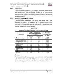
![a]ÝĖ^į %XĮ[ýįV - Pollution Control Board, Assam](https://img.yumpu.com/50573985/1/190x245/ayei-xiyiv-pollution-control-board-assam.jpg?quality=85)