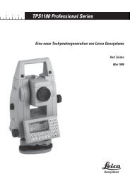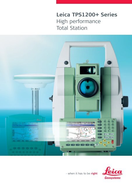
Leica TPS1200+ Series High performance Total Station
Leica TPS1200+ Series High performance Total Station
Leica TPS1200+ Series High performance Total Station

You also want an ePaper? Increase the reach of your titles
YUMPU automatically turns print PDFs into web optimized ePapers that Google loves.
<strong>Leica</strong> <strong>TPS1200+</strong> <strong>Series</strong><br />
<strong>High</strong> <strong>performance</strong><br />
<strong>Total</strong> <strong>Station</strong>
<strong>Leica</strong> <strong>TPS1200+</strong><br />
<strong>Total</strong> <strong>Station</strong>s<br />
Packed with exciting new features, built for speed, accuracy,<br />
ease-of-use and reliability. <strong>Leica</strong> <strong>TPS1200+</strong> total stations<br />
carry out even the most complex tasks, better and more<br />
efficiently than ever before. And, best of all, they combine<br />
perfectly with GPS1200+.<br />
FUNCTION<br />
integrated<br />
Superb measurement<br />
technology<br />
<strong>High</strong> accuracy angle<br />
measurements and precise<br />
long-range distance<br />
measurements backed by<br />
automatic fine pointing<br />
and fast, reliable reflector<br />
location. You work faster,<br />
more precisely and more<br />
relaxed.<br />
Easy to operate<br />
Intuitive interface, powerful<br />
data management,<br />
on-board routines and<br />
programs: all easy to<br />
use and identical for TPS,<br />
GNSS and RX1250.<br />
Large graphic colour<br />
display<br />
Easy viewing of entire<br />
surveyed area and<br />
immediate access to all<br />
measured data. You see<br />
exactly what you’ve done<br />
and what you’ve still to do.<br />
Combine TPS and GNSS. Use them in the same way.<br />
Change easily from one to the other.<br />
Work faster, more accurately and more efficiently.<br />
Enjoy all the freedom, flexibility and power of System 1200.<br />
<strong>Leica</strong> Smart<strong>Station</strong><br />
<strong>TPS1200+</strong> with integrated<br />
GNSS. All <strong>TPS1200+</strong> can be<br />
ugraded to Smart <strong>Station</strong>.<br />
<strong>Total</strong>ly flexible<br />
Configure and program<br />
<strong>TPS1200+</strong> in the way you<br />
want, for your applications,<br />
for the way you work and<br />
for the data output you<br />
require.<br />
A complete series<br />
<strong>TPS1200+</strong> total stations<br />
cover a range of models<br />
and options. Select the<br />
ones that suit you best.<br />
Use <strong>TPS1200+</strong> for<br />
everything<br />
Use <strong>TPS1200+</strong> total<br />
stations for surveying,<br />
engineering, stakeout,<br />
topo, monitoring etc.<br />
Combine them with GNSS.<br />
Benefit from huge<br />
productivity of System<br />
1200.<br />
<strong>Leica</strong> GPS1200+<br />
Unites top GNSS technology<br />
with powerful data management.<br />
Perfect for all GNSS<br />
applications.
<strong>Leica</strong> <strong>TPS1200+</strong><br />
Top <strong>performance</strong>, high<br />
accuracy total stations<br />
do everything you want<br />
and much more.<br />
<strong>Leica</strong> SmartPole<br />
Save time with SmartPoles’<br />
setup On-the-fly and easily<br />
swap between GNSS<br />
and TPS when<br />
needed.<br />
<strong>Leica</strong> System 1200<br />
TPS and GNSS<br />
Working together<br />
For all applications<br />
Today and in the future<br />
Designed and built to<br />
the most stringent<br />
standards with the latest<br />
measurement technologies,<br />
<strong>Leica</strong> System 1200<br />
instruments are extremely<br />
efficient and reliable, and<br />
stand up to the severest<br />
environments.<br />
A new, highly intuitive<br />
user interface, a multitude<br />
of functions and features,<br />
powerful data management,<br />
and user-programming<br />
capabilities are common<br />
to both System 1200 TPS<br />
and GNSS instruments.<br />
<strong>Leica</strong> SmartWorx<br />
SmartWorx TPS/GNSS<br />
application software is<br />
both easy-to-use and<br />
extremely powerful.<br />
Operators can switch<br />
instantly between TPS and<br />
GNSS and use whichever is<br />
the most convenient and<br />
suitable; extra training is<br />
not required.<br />
These new high-tech TPS<br />
and GNSS instruments<br />
with identical operation<br />
enable you to do every<br />
type of job, faster, more<br />
accurately and more efficiently<br />
than ever before.<br />
And most important,<br />
you reduce your costs and<br />
increase your profits.<br />
<strong>Leica</strong> Geo Office<br />
Everything you need in a<br />
single package for TPS and<br />
GNSS: import, visualization,<br />
conversions, quality control,<br />
processing, adjustment,<br />
reporting, export etc
<strong>Leica</strong> <strong>TPS1200+</strong><br />
Exceptional<br />
<strong>performance</strong> and<br />
outstanding features<br />
Fast, precise,<br />
long-range EDM<br />
Coaxial, high-accuracy<br />
EDM with various<br />
measuring modes. 3 km<br />
range to a single prism.<br />
Best reflectorless<br />
electronic<br />
distance measurement<br />
technology in combination<br />
of range, accuracy, measurement<br />
time and laser<br />
spot size in the market.<br />
Measure more than 1000 m<br />
range with true PinPoint<br />
accuracy.<br />
Bluetooth ® Wireless-<br />
Technology integrated<br />
Wireless transfer of data<br />
to PDA’s and cell phones.<br />
<strong>High</strong>-tech angle<br />
measurement<br />
<strong>High</strong>-accuracy continuous<br />
angle-measuring system.<br />
Choice of accuracies from<br />
1 to 5 seconds.<br />
Endless drives<br />
For fast, comfortable<br />
operation and precise<br />
pointing.<br />
RadioHandle<br />
Transfers data instantly<br />
between <strong>TPS1200+</strong> and<br />
remote control unit.<br />
Powered by <strong>TPS1200+</strong><br />
plug-in battery.<br />
Plug-in Li-Ion battery<br />
Small, light,<br />
high-capacity<br />
Lithium-Ion battery<br />
powers <strong>TPS1200+</strong> for<br />
hours and hours.<br />
Well-designed<br />
keyboard<br />
Clear, logical<br />
arrangement with<br />
alphanumeric, function<br />
and user-definable keys.<br />
Touch screen<br />
Gives instant access to all<br />
functions without using<br />
the keyboard.<br />
Laser plummet<br />
Centers <strong>TPS1200+</strong> easily,<br />
quickly and exactly over<br />
a ground point.
Guide Light (EGL)<br />
Practical alignment aid for<br />
stakeout; helps rodman<br />
to line up reflector quickly<br />
and exactly.<br />
Automatic Target<br />
Recognition (ATR):<br />
Automatic fine pointing<br />
to prism. Speeds up<br />
measurements and<br />
improves productivity.<br />
PowerSearch (PS)<br />
Fast rotating laser fan<br />
finds reflector quickly and<br />
ATR fine points. Valuable<br />
aid for all types of work;<br />
perfect for remote control<br />
surveys.<br />
<strong>High</strong> contrast<br />
graphic colour display<br />
Best colour display in the<br />
market because of perfect<br />
clarity and contrast.<br />
Excellent graphics and<br />
easy to read whether in<br />
fading light or bright<br />
sunshine.<br />
CompactFlash cards<br />
<strong>High</strong> capacity, reliable data<br />
storage. Ideal for data<br />
transfer.<br />
Internal memory<br />
<strong>High</strong> capacity, reliable<br />
internal memory.<br />
Various models and<br />
options<br />
<strong>TPS1200+</strong> total stations<br />
cover a range of standard<br />
and motorized models and<br />
various exciting options.<br />
Only pay for what you<br />
need!<br />
360° reflector<br />
No orientation required;<br />
surveying and stakeout<br />
are easier and quicker.<br />
Seamless dataflow<br />
Wide range of<br />
accessories<br />
Can also be used for<br />
GPS1200+ and other<br />
<strong>Leica</strong> equipment.<br />
SmartPole<br />
SmartAntenna, 360°<br />
reflector and the RX1250<br />
is the perfect setup to<br />
operate GNSS and TPS<br />
from one control unit.<br />
<strong>Leica</strong> Geo Office<br />
Software support package<br />
for TPS and GNSS with<br />
tools and components for<br />
import, visualization, conversions,<br />
quality control,<br />
processing, adjustment,<br />
reporting, export.<br />
RX1250 Control Unit<br />
Remote controls the <strong>TPS1200+</strong><br />
via radio modem and<br />
operates the SmartAntenna<br />
on the pole via Bluetooth ®<br />
Wireless Technology or cable.<br />
Surveyor with reflector carries<br />
out the entire GNSS and TPS<br />
survey by himself.<br />
Plug-in Li-Ion battery<br />
Small, light Lithium-ion<br />
battery powers remote<br />
control unit and integrated<br />
radio.
<strong>Leica</strong> <strong>TPS1200+</strong><br />
Extremely powerful<br />
Yet very easy to use<br />
<strong>TPS1200+</strong> is loaded with a multitude of features and<br />
functions to meet the many different needs of users all<br />
over the world, yet it is remarkably easy to use.<br />
<strong>TPS1200+</strong>’s graphical<br />
operating concept is selfexplanatory<br />
and guides<br />
you straight to what you<br />
need.<br />
You can use the default<br />
settings or, if you prefer,<br />
you can set <strong>TPS1200+</strong><br />
to operate, display and<br />
output data in exactly<br />
the way you require.<br />
When you use <strong>TPS1200+</strong><br />
you’ll find that everything<br />
is very easy to understand.<br />
Even better, <strong>TPS1200+</strong><br />
and GPS1200+ are fully<br />
compatible with the same<br />
CompactFlash cards, data<br />
management, displays and<br />
keyboards.<br />
Depending on the jobs<br />
you do, you can change<br />
easily from TPS to GNSS<br />
and continue working in<br />
exactly the same way.<br />
Graphic view mode<br />
Graphic views show your<br />
work. Zoom in for details<br />
and out for the entire<br />
survey. Use the touch<br />
screen or keyboard to<br />
access data related to<br />
points and objects.<br />
With graphical views you<br />
can check quickly in the<br />
field for completeness<br />
and correctness.<br />
Coding and plan<br />
of your work<br />
Define points, lines and<br />
areas to build up a plan in<br />
the display as you survey.<br />
You see immediately what<br />
you’ve done. Attach the<br />
codes, attributes and<br />
information needed for<br />
input into your office or<br />
mapping software.<br />
System 1200 has all<br />
types of tools and is<br />
incredibly versatile.<br />
Data export in<br />
any format<br />
Data can be exported<br />
directly from <strong>TPS1200+</strong><br />
or via <strong>Leica</strong> Geo Office in<br />
various standard formats<br />
or in your own userdefined<br />
formats for direct<br />
input into any type of<br />
processing, office, CAD<br />
or mapping software.<br />
System 1200 interfaces<br />
easily to third-party<br />
software packages.
Status icons<br />
These indicate the current<br />
instrument settings, battery<br />
status, measurement<br />
and operation modes.<br />
QWERTY keyboard<br />
The remote control unit<br />
has a standard QWERTY<br />
keyboard layout for fast,<br />
easy input of alphanumeric<br />
data and information.<br />
User definable displays<br />
With <strong>TPS1200+</strong> you can<br />
define different display<br />
masks so that the<br />
instrument shows exactly<br />
what you and your crews<br />
want to see when<br />
surveying in the field.<br />
Set the displays according<br />
to the jobs you do and<br />
the information required.<br />
<strong>TPS1200+</strong> adapts<br />
perfectly to your needs.<br />
Quick settings key<br />
For quick selection of<br />
functionality such as<br />
PinPoint, ATR, LOCK and<br />
EDM tracking.<br />
Definable function keys<br />
Allocate commands,<br />
functions and displays to<br />
those keys for immediate<br />
access.<br />
Data management<br />
The powerful database<br />
manages data, files, jobs,<br />
quality checks etc. You can<br />
view, edit, delete, and<br />
search with or without<br />
filters. Coordinates of<br />
points measured more<br />
than once are averaged<br />
provided that they lie<br />
within specified tolerances.<br />
Surveying is much easier<br />
and more reliable with<br />
System 1200.<br />
Configurable user menu<br />
Set up your own user<br />
menu for the way you and<br />
your crews operate. Show<br />
what you need and hide<br />
the rest.<br />
Program menu<br />
Direct access to all loaded<br />
application programs, such<br />
as Survey, Setup, Stakeout<br />
and all other optional<br />
application programs.<br />
Large graphic colour<br />
display<br />
1/4 VGA high-resolution<br />
LCD, easy to read in any<br />
light. Display and keyboard<br />
light up for work in the dark.<br />
Application programs<br />
<strong>TPS1200+</strong> is supplied with<br />
many useful programs<br />
such as Survey, Setup,<br />
Stakeout, COGO etc.<br />
Other programs such as<br />
RoadRunner, Reference<br />
line, Sets of Angles and<br />
DTM Stakeout are optional.<br />
You can also write your<br />
own programs for special<br />
applications in Geo C++.<br />
Most programs run on<br />
both TPS and GNSS.<br />
Second keyboard/display<br />
If required, <strong>TPS1200+</strong> can<br />
be fitted with a second<br />
keyboard and display for<br />
operating in face II.<br />
Touch screen<br />
The touch screen provides<br />
immediate access without<br />
using the keyboard.<br />
You can view data and<br />
information related to<br />
points and objects and call<br />
up all types of functions<br />
directly via the screen. Use<br />
the touch screen and/or<br />
the keyboard, whichever<br />
you prefer.
<strong>Leica</strong> <strong>TPS1200+</strong><br />
<strong>High</strong>-precision measurement technology<br />
Time-saving measurement aids<br />
Angle and distance<br />
measurement (IR-Mode)<br />
<strong>High</strong>est accuracy<br />
Longest range<br />
<strong>TPS1200+</strong>’s precision<br />
angle-measurement system<br />
operates continuously<br />
providing instant horizontal<br />
and vertical circle readings<br />
that are automatically<br />
corrected for any “out of<br />
level” by a centrally located<br />
twin-axis compensator.<br />
The coaxial EDM uses a<br />
visible red laser, has various<br />
measuring modes,<br />
and measures to prisms<br />
and reflective tape.<br />
The range is excellent –<br />
3 km to a single prism –<br />
and the accuracy superb –<br />
1 mm + 1.5 ppm for all<br />
<strong>TPS1200+</strong> models.<br />
Resolution is 0.1 mm.<br />
� Fast, continuous,<br />
high-accuracy angle<br />
measurements<br />
� Choice of accuracy<br />
from 1 to 5 seconds<br />
� No initialization<br />
� Twin-axis compensator<br />
� EDM with standard,<br />
fast and tracking modes<br />
� Long range,<br />
fast measurements<br />
and high accuracy<br />
� <strong>Total</strong>ly reliable<br />
PinPoint – reflectorless<br />
EDM (RL-Mode)<br />
Measure extreme ranges<br />
with highest accuracy<br />
PinPoint is the ideal tool for<br />
measuring to wall corners,<br />
inaccessible objects,<br />
facades, rock faces, roofs<br />
and walls inside buildings,<br />
in fact to anything at which<br />
it is difficult to set up a<br />
reflector.<br />
PinPoint’s tightly bundled<br />
laser marks the point<br />
exactly with a small red dot.<br />
Measurements are taken<br />
instantly and directly<br />
(no complex routines<br />
measurement).<br />
And with PinPoint you can<br />
also take very long distance<br />
measurements to prisms.<br />
� Optional for all <strong>TPS1200+</strong><br />
� Two versions: standard<br />
range R400 (more than<br />
400 m), superior range<br />
R1000 (more than<br />
1000 m)<br />
� Very small laser spot,<br />
marks the point exactly<br />
� Standard measurement<br />
and tracking modes<br />
� Accuracy 2 mm + 2 ppm<br />
� Motorized <strong>TPS1200+</strong><br />
with PinPoint – the<br />
perfect tool for scanning<br />
facades<br />
Automatic Target<br />
Recognition (ATR / LOCK)<br />
Measure points quick<br />
and accurate<br />
With ATR, you only need<br />
to point roughly and take<br />
a measurement; <strong>TPS1200+</strong><br />
then fine points to the<br />
center of the prism and<br />
measures, all fully automatically.<br />
In LOCK mode<br />
<strong>TPS1200+</strong> remains locked<br />
onto the reflector and<br />
follows it as it moves.<br />
Measurements can be<br />
taken at any time. And, as<br />
software predicts reflector<br />
movements, <strong>TPS1200+</strong><br />
continues to track in<br />
spite of obstructions and<br />
short interruptions. If long<br />
interruptions should cause<br />
complete loss of lock,<br />
use PowerSearch.<br />
� Optional for motorized<br />
<strong>TPS1200+</strong><br />
� Eliminates manual<br />
operation<br />
� Very fast<br />
measurements<br />
� Uniform high accuracy<br />
� Works with standard<br />
prisms (no need for<br />
active target)
Work easily, quickly and comfortably<br />
Increase productivity and profits<br />
PowerSearch<br />
(PS)<br />
Finds reflector<br />
automatically<br />
PowerSearch finds reflectors<br />
within seconds no matter<br />
where they are. With Power-<br />
Search activated,<br />
<strong>TPS1200+</strong> rotates and<br />
sends out a vertical laser<br />
fan. As soon as the fan<br />
strikes a prism <strong>TPS1200+</strong><br />
stops rotating, ATR takes<br />
over and fine points – all<br />
fully automatically.<br />
Use PowerSearch for the<br />
first ATR measurement or to<br />
find the reflector again if<br />
Automatic Target Tracking<br />
loses lock completely.<br />
PowerSearch is particularly<br />
advantageous when operating<br />
with remote control.<br />
� Optional for motorized<br />
<strong>TPS1200+</strong> equipped<br />
with ATR<br />
� Activated at the<br />
touch of a key or<br />
automatically<br />
� Finds standard prisms<br />
(no need for active<br />
target)<br />
� Saves time, increases<br />
productivity<br />
� <strong>High</strong>ly recommended<br />
for fast, efficient<br />
remote control<br />
Remote Control Unit<br />
(RX1250)<br />
Operate at the reflector<br />
With the RX1250 remote<br />
control unit you can control<br />
both the <strong>TPS1200+</strong> via<br />
RadioModem and Radio-<br />
Handle and the GNSS Smart-<br />
Antenna via Bluetooth ®<br />
Wireless Technology or<br />
cable from the reflector<br />
pole. The control unit has<br />
the same display as the<br />
<strong>TPS1200+</strong>, a touch screen,<br />
optionally a colourscreen<br />
and a full alphanumeric<br />
QWERTY keyboard.<br />
Operation is exactly the<br />
same. You can trigger measurements,<br />
enter codes,<br />
use routines and programs,<br />
collect data from GNSS and<br />
TPS – whatever you like.<br />
� Optional for all <strong>TPS1200+</strong><br />
� Extend setup to<br />
SmartPole<br />
� Best with ATR,<br />
PowerSearch and<br />
360° reflector<br />
� Light, rugged, reliable<br />
� Reliable wireless communication<br />
via Radio-<br />
Handle and Bluetooth ®<br />
Wireless Technology<br />
� Perfect one-man<br />
survey system<br />
� No need for cables<br />
� Increases efficiency<br />
and productivity<br />
Smart<strong>Station</strong><br />
(ATX1230+ GNSS)<br />
TPS & GNSS perfectly<br />
combined<br />
<strong>TPS1200+</strong> with ATX1230+<br />
GNSS Smart-Antenna combined<br />
in one compact,<br />
easy-to-use instrument.<br />
No need for control<br />
points, traverses or resections.<br />
Set up Smart<strong>Station</strong><br />
and let RTK GNSS determine<br />
the position within<br />
seconds to centimeter<br />
accuracy, then survey and<br />
stake out with <strong>TPS1200+</strong>.<br />
The total station controls<br />
all measurements, displays<br />
and data, for both GNSS<br />
and TPS. Once Smart<strong>Station</strong><br />
is positioned, use the<br />
Smart-Antenna on a pole<br />
with controller and sensor<br />
as an RTK rover.<br />
� TPS and GNSS combined<br />
into one instrument<br />
� Fix the position<br />
with RTK then survey<br />
with TPS<br />
� No need for control<br />
points, traverses or<br />
resections<br />
� Increase productivity<br />
and profits<br />
� All <strong>TPS1200+</strong> can<br />
be upgraded to<br />
Smart<strong>Station</strong>
<strong>Leica</strong> <strong>TPS1200+</strong><br />
Technical specifications<br />
and system features<br />
Models and options<br />
TC TCR TCRM TCA TCP TCRA TCRP<br />
Angle measurement • • • • • • •<br />
Distance measurement (IR-Mode) • • • • • • •<br />
PinPoint reflectorless dist. measurem. (RL-Mode) • • • •<br />
Motorized • • • • •<br />
Automatic Target Recognition (ATR) • • • •<br />
PowerSearch (PS) • •<br />
Guide Light (EGL) ° ° ° • • • •<br />
Remote Control Unit / RadioHandle ° ° ° ° ° ° °<br />
GUS74 Laser Guide ° °<br />
Smart<strong>Station</strong> (ATX1230+ GNSS) ° ° ° ° ° ° °<br />
• = Standard ° = Optional<br />
Angle measurement<br />
Type 1201+ Type 1202+ Type 1203+ Type 1205+<br />
Accuracy (std.dev., ISO 17123-3) Hz, V 1’’ (0.3 mgon) 2’’ (0.6 mgon) 3’’ (1 mgon) 5’’ (1.5 mgon)<br />
Display resolution: 0.1’’ (0.1 mgon) 0.1’’ (0.1 mgon) 0.1’’ (0.1 mgon) 0.1’’ (0.1 mgon)<br />
Method absolute, continuous, diametrical<br />
Compensator Working range: 4’ (0.07 gon) 4’ (0.07 gon) 4’ (0.07 gon) 4’ (0.07 gon)<br />
Setting accuracy: 0.5’’ (0.2 mgon) 0.5’’ (0.2 mgon) 1.0’’ (0.3 mgon) 1.5’’ (0.5 mgon)<br />
Method: centralized dual axis compensator<br />
Distance measurement (IR-Mode)<br />
Range Round prism (GPR1): 3000 m<br />
(average atmospheric conditions) 360° reflector (GRZ4): 1500 m<br />
Mini prism (GMP101): 1200 m<br />
Reflective tape (60 mm x 60mm) 250 m<br />
Shortest measurable distance: 1.5 m<br />
Accuracy / Measurement time Standard mode: 1 mm + 1.5 ppm / typ. 2.4 s<br />
(standard deviation, ISO 17123-4) Fast mode: 3 mm + 1.5 ppm / typ. 0.8 s<br />
Tracking mode: 3 mm + 1.5 ppm / typ. 500 m: 4 mm + 2 ppm / typ. 3 – 6 s, max. 12 s<br />
(object in shade, sky overcast) Long Range: 5 mm + 2 ppm / typ. 2.5 s, max. 12 s<br />
Laser dot size At 30 m: approx. 7 mm x 10 mm<br />
At 50 m: approx. 8 mm x 20 mm<br />
Method PinPoint R400 / R1000: System analyzer (coaxial, visible red laser)<br />
Motorized<br />
Maximum speed Rotating speed: 45° / s
Automatic Target Recognition (ATR)<br />
Range ATR mode / LOCK mode Round prism (GPR1): 1000 m / 800 m<br />
(average atmospheric conditions) 360° reflector (GRZ4, GRZ122): 600 m / 500 m<br />
Mini prism (GMP101): 500 m / 400 m<br />
Reflective tape (60 mm x 60 mm): 55 m (175 ft)<br />
Shortest measurable distance: 1.5 m / 5 m<br />
Accuracy / Measure time ATR angle accuracy Hz, V: 1 " (0.3 mgon)<br />
(std. dev. ISO 17123-3) Base positioning accuracy: ± 1mm<br />
Measure time for GPR1: 3 – 4 s<br />
Maximum speed (LOCK mode) Tangential (standard mode): 5 m / s at 20 m, 25 m / s at 100 m<br />
Radial (tracking mode): 4 m / s<br />
Method Digital image processing (laser beam)<br />
PowerSearch (PS)<br />
Range Round prism (GPR1): 300 m<br />
(average atmospheric conditions) 360° reflector (GRZ4, GRZ122): 300 m (perfectly aligned to instrument)<br />
Mini prism (GMP101): 100 m<br />
Shortest distance: 5 m<br />
Search time Typical search time: < 10 s<br />
Maximum speed Rotating speed: 45° / s<br />
Method Digital signal processing (rotating laser fan)<br />
Guide Light (EGL)<br />
Range<br />
(average atmospheric conditions) Working range: 5 m – 150 m<br />
Accuracy Positioning accuracy: 5 cm at 100 m<br />
General data<br />
Telescope Laser plummet<br />
Magnification: 30 x Centering accuracy: 1.5 mm at 1.5 m<br />
Free objective aperture: 40 mm Laser dot diameter: 2.5 mm at 1.5 m<br />
Field of view: 1°30’ (1.66 gon) / 2.7 m at 100 m Endless drives<br />
Focusing range: 1.7 m to infinity Number of drives: 1 horizontal / 1 vertical<br />
Keyboard and Display Battery (GEB221)<br />
Display: 1/4 VGA (320*240 pixels), graphic LCD, colour, illumination, Type: Lithium-Ion<br />
touch screen Voltage: 7.4 V<br />
Keyboard: 34 keys (12 function keys, 12 alphanumeric keys), illumination Capacity: 4.4 Ah<br />
Angle display: 360° ’ ’’, 360° decimal, 400 gon, 6400 mil, V% Operating time: typ. 5 – 8 h<br />
Distance display: meter, int. ft, int. ft/inch, US ft, US ft/inch Weights<br />
Position: face I standard / face II optional <strong>Total</strong> station: 4.8 – 5.5 kg<br />
Data storage Battery (GEB221): 0.2 kg<br />
Internal memory: 256 MB (optional) Tribrach (GDF121): 0.8 kg<br />
Memory card: CompactFlash cards (256 MB) Environmental specifications<br />
Number of data records: 1750 / MB Working temperature range: –20° C to +50° C<br />
Interfaces: RS232, Bluetooth ® Wireless-Technology (optional) Storage temperature range: –40° C to +70° C<br />
Circular Level Dust / water (IEC 60529): IP54<br />
Sensitivity: 6’ / 2 mm Humidity: 95 %, non-condensing<br />
Remote Control Unit (RX1250T/Tc)<br />
Communication via integrated radio modem<br />
Control unit Display: 1/4 VGA (320*240 pixels), graphic LCD, touch screen, illumination<br />
Keyboard: 62 keys (12 function keys, 40 alphanumeric keys), illumination<br />
Interface: RS232<br />
Battery (GEB211) Type: Lithium-Ion<br />
Voltage: 7.4 V<br />
Capacity: 2.2 Ah<br />
Operating time: RX1250T: typ. 9 h, RX1250Tc: typ. 8 h<br />
Weights Control unit RX1250T/Tc: 0.8 kg<br />
Battery (GEB211): 0.1 kg<br />
Reflector pole adapter: 0.25 kg<br />
Environmental specifications Working temperature range: RX1250T –30° C to +65° C / RX1250Tc –30° C to +50° C<br />
Storage temperature range: –40° C to +80° C<br />
Protection against water, dust and sand IP67<br />
(IEC 60529, MIL-STD-810F) waterproof to 1 m temporary submersion, dust tight
<strong>Total</strong> Quality Management –<br />
our commitment to total<br />
customer satisfaction.<br />
Ask your local <strong>Leica</strong> Geosystems<br />
dealer for more information<br />
about our TQM program.<br />
Distance meter (Prism),<br />
ATR and PowerSearch:<br />
Laser class 1 in accordance<br />
with IEC 60825-1 resp. EN<br />
60825-1<br />
Laser plummet:<br />
Laser class 2 in accordance<br />
with IEC 60825-1 resp. EN<br />
60825-1<br />
Distance meter (Non-Prism):<br />
Laser class 3R in accordance<br />
with IEC 60825-1 resp.<br />
EN 60825-1<br />
The Bluetooth ® word mark and<br />
logos are owned by Bluetooth<br />
SIG, Inc. and any use of such<br />
marks by <strong>Leica</strong> Geosystems AG is<br />
under license. Other trademarks<br />
and trade names are those of<br />
their respective owners.<br />
<strong>Leica</strong> Geosystems AG<br />
Heerbrugg, Switzerland<br />
www.leica-geosystems.com<br />
<strong>Leica</strong> SmartPole<br />
Measure non-stop<br />
with setup On-the-Fly<br />
Lorem <strong>Leica</strong> ipsumSmartPole<br />
dolor sit. Product brochure<br />
Adipisicing elit,<br />
sed do eiusmod<br />
tempor incididunt<br />
ut labore et.<br />
Whether you want to survey a parcel of land or a construction site, a<br />
facade or indoors to create as-built plans or carry out high-precision<br />
measurements of bridge and tunnel constructions – <strong>Leica</strong> Geosystems’<br />
surveying instruments provide the right solution for all measuring tasks.<br />
The System 1200 <strong>Series</strong> instruments as well as the software are designed<br />
to meet the daily challenges of modern surveying. They all have<br />
outstanding, easy to read and user-friendly interfaces. Their straightforward<br />
menu structures, their clearly outlined scope of functions and<br />
high technology perfectly mate GNSS and TPS applications in the field.<br />
Whether you use the advantages of both technologies combined or each<br />
separately – due to the exceptional flexibility of <strong>Leica</strong> Geosystems<br />
instruments, reliable and productive surveying is assured.<br />
When it has to be right.<br />
Illustrations, descriptions and technical specifications are not binding and may change.<br />
Printed in Switzerland – Copyright <strong>Leica</strong> Geosystems AG, Heerbrugg, Switzerland, 2009.<br />
738582en – V.09 – RDV<br />
<strong>Leica</strong> Smart<strong>Station</strong><br />
<strong>Total</strong> <strong>Station</strong><br />
with integrated GNSS<br />
<strong>Leica</strong><br />
Smart<strong>Station</strong><br />
Product brochure<br />
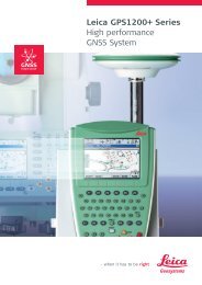
<strong>Leica</strong> GPS1200+ <strong>Series</strong><br />
<strong>High</strong> <strong>performance</strong><br />
GNSS System<br />
<strong>Leica</strong> GPS1200+<br />
Product brochure<br />
<strong>Leica</strong> System 1200<br />
Software<br />
Product brochure<br />
<strong>Leica</strong> GRX1200+ <strong>Series</strong><br />
<strong>High</strong> Performance<br />
GNSS Reference Receivers<br />
<strong>Leica</strong> GRX1200+<br />
Product brochure