Cal Poly Geology Club Death Valley Field Trip â 2004
Cal Poly Geology Club Death Valley Field Trip â 2004
Cal Poly Geology Club Death Valley Field Trip â 2004

Create successful ePaper yourself
Turn your PDF publications into a flip-book with our unique Google optimized e-Paper software.
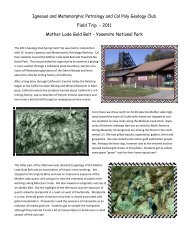
north and south by major, east-trending faults. The more northerly of the faults occupiesthe gap that separates the Alexander Hills from the Nopah Range proper.The Crystal Spring Formation, containing all of the typical members, is exposed for adistance of about 2 3/4 miles along the lower part of the west face of the hills. Theformation contains a talc-bearing zone which has formed along the upper margin of adiabase sill and is an alteration of cherty dolomite at the base of the carbonate member.At the southern end of the Alexander Hills, the Crystal Spring Formation is successivelyover-lain by the Beck Spring Dolomite and Kingston peak Formation to form one of thefew essentially complete occurrences of the Pahrump Group west of the Kingston Range.From this locality, for a distance of about seven miles northward, successively lowerunits in the Pahrump Group are progressively cut out along the contact with the overlyingNoonday Dolomite, so that in the southem end of the Nopah Range, strata of the CrystalSpring Formation wedge out northward, and the Noonday Dolomite rests directly uponearlier Precambrian metamorphic rocks. Most of the talc that has been mined in the areaof the Alexander Hills and southern Nopah Range has been obtained from two northtrendingsegments of the talc-bearing zone, each on the west side of the hills. The moresoutheasterly segment about 1 ½ miles long, contains most of the workings of theWestern mine and the Acme mine. For a distance of about half a mile between the twomines the zone lies unexposed and unexplored beneath Tertiary fanglomerate. The othersegment of the zone, which appears to be at least 2700 feet long, contains the remainingworkings of the Western mine. Movement along a northeast-trending fault has separatedthe two an apparent horizontal distance of about 4000 feet so that the southern segmenthas moved northeastward with respect to the other.Another talc deposit is contained in highly faulted rocks at the southeastern tip of theAlexander Hills and is the site of the Booth mine. This deposit occurs along a nearlyhorizontal fault-contact between earlier Precambrian metamorphic rocks and dolomite ofthe Crystal Spring Formation, In a similar geologic setting is the talc deposit at the DonnaLoy mine, which is near the tip of the wedge of Crystal Spring strata in the southern partof the Nopah Range.Figure 2. View looking northeastward of Alexander Hills, showing theWestern mine area.