Cal Poly Geology Club Death Valley Field Trip â 2004
Cal Poly Geology Club Death Valley Field Trip â 2004
Cal Poly Geology Club Death Valley Field Trip â 2004

You also want an ePaper? Increase the reach of your titles
YUMPU automatically turns print PDFs into web optimized ePapers that Google loves.
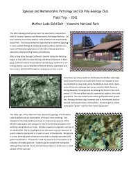
29.5 (1.2) Turn right (west) on Furnace Creek Road.31.1 (0.6) Turn left on Western Talc Mine Road.34.3 (3.0) Park near the open pit of the Western Talc Mine (STOP 3).Talc was first produced from <strong>Death</strong> <strong>Valley</strong> in 1910. Pressure from the ParkService in the form of an asbestosscare closed all mines within thepark in 1980. Production outsideof the park continued until thelate 1990’s. In their heyday the<strong>Death</strong> <strong>Valley</strong> talc mines yielded20% of the annual talc tonnage.All talc deposits lie within theCrystal Springs Formation andoutcrop along a 50 mile belt fromthe Panamint Mountains to theKingston Range. Specifically, thetalc ore bodies are the products ofcontact metamorphism ofcarbonate layers during intrusion of Proterozoic diabase sills.The Western mine has the most extensive workings and the longest operatinghistory of the talc mines in the southern <strong>Death</strong> <strong>Valley</strong>-Kingston Range region.The property consists of seven patented and four unpatented claims, formerlyowned and operated by the Western Talc Company.Here, as at numerous other localities in the surrounding region, the talc-bearingzone has formed as an alteration of cherty dolomite at the base of the CrystalSpring Formation. A diabase sill forms the footwall of the talc bodies throughmost of the mine area, but in the southern part, elongate bodies of greenalteration rock separate the talc from diabase.Most of the claims are distributed along two north-striking segments of thesame alteration zone that are displaced along a northeast-striking fault. The twosegments have a combined strike length of several thousand feet and appear tobe the largest intact bodies of commercial talc in the <strong>Death</strong> <strong>Valley</strong> region.In mine exposures, the zone of talcose alteration is 30 to 100 feet thick andconsists chiefly of saleable material. The zone contains two principal types ofcommercial talc: (1) laminated tremolite rock (generally referred to as “hardtalc”) which occurs as a 10-20 foot thick layer in the lower part of the zone, and(2) talc schist (generally referred to as “soft talc”) most of which is confined tothe upper part of the zone. A thick layer of brown alteration rock ordinarilyforms the upper part of the zone, separating talc schist from unaltered chertydolomite. The brown rock is in sharp contact with the talc schist, but has agradational contact with the overlying cherty dolomite.