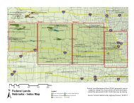
Flash’s Photographyresort towns of Cooke City and RedLodge, connecting them on a twolane,roughly crescent-shaped roadwaythat bends southward intoWyoming when viewed from above.About 200,000 people enteredYellowstone through the park’snortheastern gate near Cooke City in2004, most via the highway, accordingto the U.S. Department of theInterior’s National Park Service (NPS).Despite its renown and significanceto the local economy, thehighway has suffered neglect overthe years. Even though the Beartoothcarries visitors to the Nation’s oldestnational park and zigzags throughthree national forests, three counties,and two States, no government agencyhas claimed ownership of largesegments of the roadway throughmuch of its history, earning it thenickname the “orphaned highway.”Since the mid-1990s, however,the FHWA <strong>Federal</strong> <strong>Lands</strong> <strong>Highway</strong><strong>Division</strong> (FLHD) has worked withNPS, the U.S. Department of Agriculture’s(USDA) Forest Service,the Montana Department of Transportation(MDT), and other partnerson a major initiative to resolve thehighway’s ownership and maintenanceissues. The goal is to repairand upgrade substandard sections tomeet current State highway standardsso that the relevant countiesor States can adopt the portions ofthe highway within their boundariesinto their road systems, therebyensuring long-term stewardship.Partners acknowledge hurdles inthe endeavor. “It is quite challengingbuilding a project with such controversyregarding ownership,” saysAmong other things, the Beartooth <strong>Highway</strong> was intended to spur tourism andcommerce in Red Lodge, shown here during the Memorial Day parade in 1927.The seven segments of the Beartooth <strong>Highway</strong> designated during the planningfor the reconstruction are shown on this map. Segment 1, to the left, andsegment 4, in the middle, are the focus of the reconstruction, while theswitchback area of segment 5 was the site of May 2005 mudslides andsubsequent emergency repairs that summer.Project Engineer Jason Hahn, whomanages a portion of the projectfor FHWA’s Western <strong>Federal</strong> <strong>Lands</strong><strong>Highway</strong> <strong>Division</strong> (WFLHD), “tryingto figure out for whom you are buildingthe road—the Forest Service, theNational Park Service, or the MontanaDepartment of Transportation.”But, adds Larry Smith, recentlyretired division engineer for FHWA’s<strong>Central</strong> <strong>Federal</strong> <strong>Lands</strong> <strong>Highway</strong> <strong>Division</strong>(CFLHD), interagency cooperationhas been instrumental in constructionand resolving ownership.“The development of solutions forthe future of the Beartooth <strong>Highway</strong>has been successful due to the partnershipdeveloped among the manystakeholders and their drive for success,”he says.Despite the challenges of interagencycooperation and a recentnatural disaster that set the projectback, reconstruction is underway,and the Beartooth may yet find apermanent steward.HistoryThe Beartooth <strong>Highway</strong> came intoexistence after the automobile becamea popular method of traveling toYellowstone, beginning around 1915.The introduction of cars spurred arapid rise in local tourism, with guestPUBLIC ROADS • July/August • 2006 19
A History of Mixed FortunesAlthough the original construction of the Beartooth <strong>Highway</strong> was completed according to schedule andbudget, the fortunes of its contractors were not so uniformly successful. McNutt & Pyle of Eugene, OR,was responsible for the 40.2-kilometer (25-mile) stretch heading up the western slope of the BeartoothPlateau and over Beartooth Pass to the Montana-Wyoming border. The company’s $478,000 bid was$40,000 below the engineering estimate and $200,000 below the only other bid, causing fear in somethat the firm did not know what it was getting into.History proved that the firm underestimated the costs. McNutt & Pyle had only begun working withmechanized equipment 2 years earlier, in 1929, having used horses for power in all its grading contractsuntil then. The company had never worked a project so large and technically complex, or so demandingof qualified workers. It spent $30,000 building a “tote road” from Cooke City to the western end of itsproject to move equipment and supplies. At the same time, the firm had its two excavation teams “walktheir shovels into the project” from Gardiner, MT, 129 kilometers (80 miles) away, observed an incredulousBPR engineer, Harry Mitchell.Mitchell claimed the company would reach Beartooth Lake, roughly the contract’s midpoint, in 30days. But by the end of the first construction season in late 1931, according to Mitchell, the contractorhad “practically demolished” the little equipment it did have on the glacial boulders and solid rock reefsthat lay in the path. Workers would not reach Beartooth Lake for another year.As winter set in, the company continued to house its workers at a temporary camp on Muddy Creek.A large tent became a makeshift mess hall. Many families simply left for fear of freezing to death. Thisfreed up tents for other uses at least, and on one occasion, a work crew drove a truck in need of repairinto a large vacant tent. In keeping with the company’s luck, however, the tent burned to the ground andthe truck was barely saved when a fire lit from old crankcase oil for warmth spread.McNutt & Pyle merged with Washburn & Hall later in the winter. BPR forced a project reorganizationenabling Washburn & Hall managers to supervise McNutt & Pyle workers directly. Mitchell credited thiswith the ability of the firm to finally complete the project.By comparison, the Morrison-Knudsen Company of Boise, ID, was much more efficient. Morrison-Knudsen worked on the difficult switchback area, the 19.3-kilometer (12-mile) section extending from theState line northeast to Quad Creek. The firm also was responsible for an 8-kilometer (5-mile) section fromthe eastern end of the first section to the beginning of the <strong>Federal</strong>-aid portion 13.8 kilometers (8.6 miles)outside Red Lodge in Custer National Forest.Morrison-Knudsen drew on its experience with three large grading projects inside Yellowstone in1929–1931, employing more experienced construction managers and skilled workers than McNutt & Pylehad. The company kept employee morale high by providing good working conditions. Its camp had widestreets, electric lighting, clean and reliable water supplies, and houses that were weatherproofed againstthe cold. A blacksmith shop enabled workers to undertake practically any repair.The Beartooth took its toll on McNutt & Pyle, however, and the company went bankrupt, despitethe merger, soon after completing its work. Some subcontractors on the roadwork went the same way,while other contractors—mainly S. J. Groves & Sons and Winston Brothers Company—at least survived.Morrison-Knudsen, on the other hand, prospered on the Beartooth, becoming a world-class mining,engineering, and construction conglomerate decades later.Flash’s PhotographyIn July 1931, this Grane & Company shovel and truck was helpingin the early stages of construction of the Beartooth.ranches, lodges, and hunting facilitiesbeckoning travelers to come and viewthe scenery and wildlife.The rise in tourism and the needto support the local mining industryincreased demand for better roads.In 1925 the Forest Service andFHWA’s predecessor, the Bureauof Public Roads (BPR), conductedthe first known feasibility studiesfor a new road from Cooke City toRed Lodge.Around this time, groups fromboth towns began lobbying the U.S.Congress to finance an eastern approachto Yellowstone. Finally, inJanuary 1931, President HerbertHoover signed the National ParkApproaches Act, and the RedLodge–Cooke City route was thefirst park road to receive funding.But the law contained general restrictionsthat affected the Beartooth<strong>Highway</strong>. One stricture was that apark approach road could not bemore than 96.6 kilometers (60miles) long. The final Beartoothalignment, however, measured 110.4kilometers (68.6 miles). To coverthe excess mileage, the remaining13.8 kilometers (8.6 miles) to thewest of Red Lodge would be designatedas part of the <strong>Federal</strong>-aid highwaysystem, with another shortportion inside Custer NationalForest placed under the jurisdictionof the forest highway system.Financing was sorted out byspring 1931, with support comingfrom forest highway, <strong>Federal</strong>-aid,and park approach act funding.NPS allocated the first $1 millionfor initial construction of the 96.6kilometers (60 miles) covered underthe park approach act. Montanaconstructed the <strong>Federal</strong>-aid sectionand incorporated it into the Statehighway system.A 1926 NPS-BPR agreement signedduring construction of Glacier NationalPark’s Going-to-the Sun Road hadgiven BPR responsibility for designingand building roads throughout theentire national park system. ThereforeBPR managed the work along thesection of the Beartooth being builtunder the park approach act. Thefirst contracts were let in June 1931,and actual construction began laterthat summer. Despite presentingserious engineering and logisticalchallenges for contractors, the highwaywas completed on time andwithin budget.20PUBLIC ROADS • July/August • 2006