addressing climate change adaptation in regional transportation plans
addressing climate change adaptation in regional transportation plans
addressing climate change adaptation in regional transportation plans
You also want an ePaper? Increase the reach of your titles
YUMPU automatically turns print PDFs into web optimized ePapers that Google loves.
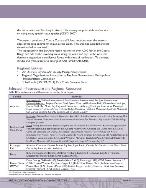
the Sacramento and San Joaqu<strong>in</strong> rivers. This estuary supports rich biodiversity,<strong>in</strong>clud<strong>in</strong>g many special-status species (CDFG, 2007).The eastern portions of Contra Costa and Solano counties meet the westernedge of the area commonly known as the Delta. This area has subsided and haselevations below sea level.The topography <strong>in</strong> the Bay Area region reaches to over 4,000 feet <strong>in</strong> the CoastalRange and falls to the low-ly<strong>in</strong>g areas along the coast and bay. In the west, thedom<strong>in</strong>ant vegetation is coniferous forest with a mix of hardwoods. To the east,shrubs and grasses beg<strong>in</strong> to emerge (FRAP, 1998; FRAP, 2003).Regional Entities• Air Districts: Bay Area Air Quality Management District• Regional Organizations: Association of Bay Area Governments, MetropolitanTransportation Commission• Tribal Lands (U.S. EPA, 2011): Dry Creek, Stewarts Po<strong>in</strong>tSelected Infrastructure and Regional ResourcesTable 10. Infrastructure and Resources <strong>in</strong> the Bay Area RegionTypesAirportsNational andState ParksPassengerRailPortsNamesInternational: Oakland International, San Francisco International, San Jose InternationalGeneral Aviation: Angw<strong>in</strong>-Parrett Field, Byron, Concord/Buchanan Field, Cloverdale Municipal,Gnoss Field, Half Moon Bay, Hayward Executive, Healdsburg Municipal, Livermore Municipal,Napa County, Nut Tree Airport, Ocean Ridge, Palo Alto, Petaluma Municipal, Rio Vista Municipal,San Carlos, Sonoma County, Sonoma Valley, South CountyNational: Golden Gate National Recreation Area, Gulf of the Farallones National Mar<strong>in</strong>e Sanctuary, MuirWoods National Monument, Po<strong>in</strong>t Reyes National Seashore, San Francisco Bay National Wildlife RefugeComplex (7 sites)State: Albany State Mar<strong>in</strong>e Reserve, Angel Island S.P., Annadel S.P., Ano Nuevo S.P., Armstrong RedwoodsNatural Reserve, Big Bas<strong>in</strong> Redwoods S.P., Bothe-Napa Valley S.P., Butano S.P., Castle Rock S.P., Ch<strong>in</strong>aCamp S.P., Eastshore S.P., Emeryville Crescent State Mar<strong>in</strong>e Reserve, Henry W. Coe S.P., KruseRhododendron Natural Reserve, Mount Diablo S.P., Mount Tamalpais S.P., Pacheco S.P., Portola RedwoodsS.P., Robert Louis Stevenson S.P., Robert W. Crown Memorial Beach, Salt Po<strong>in</strong>t S.P., Samuel P. Taylor S.P.,San Bruno Mounta<strong>in</strong> S.P., Sonoma Coast S.P., Sugarloaf Ridge S.P., Tomales Bay S.P.Altamont Commuter Express, Amtrak, Bay Area Rapid Transit, Caltra<strong>in</strong>, San Francisco Muni Metro, SantaClara Valley Transportation AuthorityBulk and Conta<strong>in</strong>er: Benicia, Oakland, Pittsburg, Richmond, Redwood City, San FranciscoOther: Pillar Po<strong>in</strong>t Harbor, Porto Bodega Mar<strong>in</strong>aPower Plants(MWs)*Duke Energy Oakland (165), Newby Island 2 (6.5), Pittsburg (1310), GWF Power Systems L.P.(22.8), Foster-Wheeler Mart<strong>in</strong>ez Cogen L.P. (114), Nove Power Plant (3), American CanyonPower Plant (1.7), Hunters Po<strong>in</strong>t (215), United Cogen Inc. (31), Gianera (49.5), Gas RecoverySystems-Fremont (3.75), Solano Cogen (1.45)S.P. = State Park; MWs = megawatts*Located with<strong>in</strong> the 100-year flood zone for 1.5-meter sea level riseAPG: UNDERSTANDING REGIONAL CHARACTERISTICS PAGE 30


