

addressing climate change adaptation in regional transportation plans
addressing climate change adaptation in regional transportation plans
addressing climate change adaptation in regional transportation plans

You also want an ePaper? Increase the reach of your titles
YUMPU automatically turns print PDFs into web optimized ePapers that Google loves.
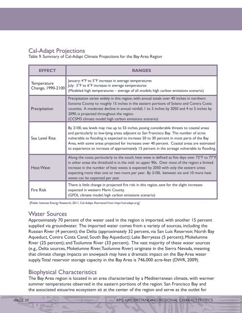
Cal-Adapt ProjectionsTable 9. Summary of Cal-Adapt Climate Projections for the Bay Area RegionEffectTemperatureChange, 1990-2100PrecipitationSea Level RiseHeat WaveFire RiskRangesJanuary: 4°F to 5°F <strong>in</strong>crease <strong>in</strong> average temperaturesJuly: 5°F to 6°F <strong>in</strong>crease <strong>in</strong> average temperatures(Modeled high temperatures – average of all models; high carbon emissions scenario)Precipitation varies widely <strong>in</strong> this region, with annual totals over 40 <strong>in</strong>ches <strong>in</strong> northernSonoma County to roughly 15 <strong>in</strong>ches <strong>in</strong> the eastern portions of Solano and Contra Costacounties. A moderate decl<strong>in</strong>e <strong>in</strong> annual ra<strong>in</strong>fall, 1 to 3 <strong>in</strong>ches by 2050 and 4 to 5 <strong>in</strong>ches by2090, is projected throughout the region.(CCSM3 <strong>climate</strong> model; high carbon emissions scenario)By 2100, sea levels may rise up to 55 <strong>in</strong>ches, pos<strong>in</strong>g considerable threats to coastal areasand particularly to low-ly<strong>in</strong>g areas adjacent to San Francisco Bay. The number of acresvulnerable to flood<strong>in</strong>g is expected to <strong>in</strong>crease 20 to 30 percent <strong>in</strong> most parts of the BayArea, with some areas projected for <strong>in</strong>creases over 40 percent. Coastal areas are estimatedto experience an <strong>in</strong>crease of approximately 15 percent <strong>in</strong> the acreage vulnerable to flood<strong>in</strong>g.Along the coast, particularly to the south, heat wave is def<strong>in</strong>ed as five days over 72°F to 77°F;<strong>in</strong> other areas the threshold is <strong>in</strong> the mid- to upper 90s. Over most of the region a limited<strong>in</strong>crease <strong>in</strong> the number of heat waves is expected by 2050 with only the eastern areasexpect<strong>in</strong>g more than one or two more per year. By 2100, between six and 10 more heatwaves can be expected per year.There is little <strong>change</strong> <strong>in</strong> projected fire risk <strong>in</strong> this region, save for the slight <strong>in</strong>creasesexpected <strong>in</strong> western Mar<strong>in</strong> County.(GFDL <strong>climate</strong> model; high carbon emissions scenario)[Public Interest Energy Research, 2011. Cal-Adapt. Retrieved from http://cal-adapt.org]Water SourcesApproximately 70 percent of the water used <strong>in</strong> the region is imported, with another 15 percentsupplied via groundwater. The imported water comes from a variety of sources, <strong>in</strong>clud<strong>in</strong>g theRussian River (4 percent); the Delta (approximately 32 percent, via San Luis Reservoir, North BayAqueduct, Contra Costa Canal, South Bay Aqueduct); Lake Berryessa (5 percent); MokelumneRiver (25 percent); and Tuolumne River (33 percent). The vast majority of these water sources(e.g., Delta sources, Mokelumne River, Tuolumne River) orig<strong>in</strong>ate <strong>in</strong> the Sierra Nevada, mean<strong>in</strong>gthat <strong>climate</strong> <strong>change</strong> impacts on snowpack may have a dramatic impact on the Bay Area watersupply. Total reservoir storage capacity <strong>in</strong> the Bay Area is 746,000 acre-feet (DWR, 2009).Biophysical CharacteristicsThe Bay Area region is located <strong>in</strong> an area characterized by a Mediterranean <strong>climate</strong>, with warmersummer temperatures observed <strong>in</strong> the eastern portions of the region. San Francisco Bay andthe associated estuar<strong>in</strong>e ecosystem sit at the center of the region and serve as the outlet forPAGE 29APG: UNDERSTANDING REGIONAL CHARACTERISTICS


