- Page 1:
Addressing Climate Change Adaptatio
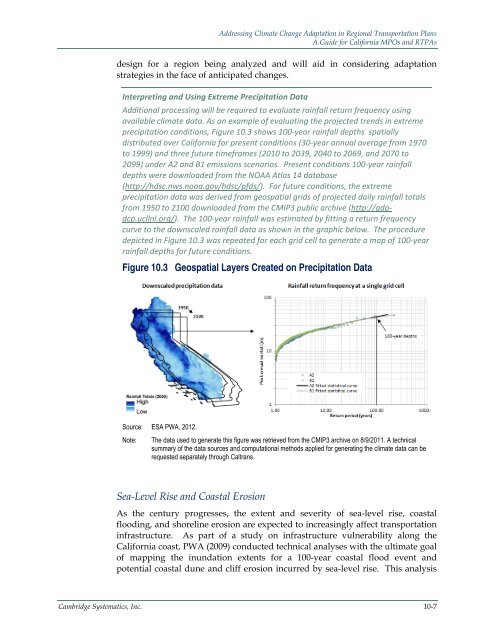
- Page 7:
Addressing Climate Change Adaptatio
- Page 13 and 14:
Addressing Climate Change Adaptatio
- Page 15:
Addressing Climate Change Adaptatio
- Page 20 and 21:
Addressing Climate Change Adaptatio
- Page 22 and 23:
Addressing Climate Change Adaptatio
- Page 24 and 25:
Addressing Climate Change Adaptatio
- Page 26 and 27:
Addressing Climate Change Adaptatio
- Page 28 and 29:
Addressing Climate Change Adaptatio
- Page 30 and 31:
Addressing Climate Change Adaptatio
- Page 32 and 33:
Addressing Climate Change Adaptatio
- Page 35 and 36:
Addressing Climate Change Adaptatio
- Page 37 and 38:
Addressing Climate Change Adaptatio
- Page 39 and 40:
Addressing Climate Change Adaptatio
- Page 41 and 42:
Addressing Climate Change Adaptatio
- Page 43 and 44:
Addressing Climate Change Adaptatio
- Page 45 and 46:
Addressing Climate Change Adaptatio
- Page 47:
Addressing Climate Change Adaptatio
- Page 50 and 51:
Addressing Climate Change Adaptatio
- Page 52 and 53:
Addressing Climate Change Adaptatio
- Page 54 and 55:
Addressing Climate Change Adaptatio
- Page 56 and 57: Addressing Climate Change Adaptatio
- Page 58 and 59: Addressing Climate Change Adaptatio
- Page 61 and 62: Addressing Climate Change Adaptatio
- Page 63 and 64: Addressing Climate Change Adaptatio
- Page 65: Addressing Climate Change Adaptatio
- Page 68 and 69: Addressing Climate Change Adaptatio
- Page 70 and 71: Addressing Climate Change Adaptatio
- Page 72 and 73: Addressing Climate Change Adaptatio
- Page 75 and 76: Addressing Climate Change Adaptatio
- Page 77 and 78: Addressing Climate Change Adaptatio
- Page 79 and 80: Addressing Climate Change Adaptatio
- Page 81 and 82: Addressing Climate Change Adaptatio
- Page 83: Addressing Climate Change Adaptatio
- Page 86 and 87: Addressing Climate Change Adaptatio
- Page 88 and 89: Addressing Climate Change Adaptatio
- Page 90 and 91: Addressing Climate Change Adaptatio
- Page 92 and 93: Addressing Climate Change Adaptatio
- Page 94 and 95: Addressing Climate Change Adaptatio
- Page 96 and 97: Addressing Climate Change Adaptatio
- Page 98 and 99: Addressing Climate Change Adaptatio
- Page 101 and 102: Addressing Climate Change Adaptatio
- Page 103 and 104: Addressing Climate Change Adaptatio
- Page 105: Addressing Climate Change Adaptatio
- Page 109 and 110: Addressing Climate Change Adaptatio
- Page 111 and 112: Addressing Climate Change Adaptatio
- Page 113 and 114: Addressing Climate Change Adaptatio
- Page 115 and 116: Addressing Climate Change Adaptatio
- Page 117 and 118: Addressing Climate Change Adaptatio
- Page 119 and 120: Addressing Climate Change Adaptatio
- Page 121 and 122: Addressing Climate Change Adaptatio
- Page 123 and 124: Addressing Climate Change Adaptatio
- Page 125 and 126: Addressing Climate Change Adaptatio
- Page 127: Addressing Climate Change Adaptatio
- Page 130 and 131: Addressing Climate Change Adaptatio
- Page 132 and 133: Addressing Climate Change Adaptatio
- Page 134 and 135: Addressing Climate Change Adaptatio
- Page 136 and 137: Addressing Climate Change Adaptatio
- Page 138 and 139: Addressing Climate Change Adaptatio
- Page 140 and 141: Addressing Climate Change Adaptatio
- Page 142 and 143: Addressing Climate Change Adaptatio
- Page 144 and 145: Addressing Climate Change Adaptatio
- Page 146 and 147: Addressing Climate Change Adaptatio
- Page 149 and 150: Addressing Climate Change Adaptatio
- Page 151 and 152: Addressing Climate Change Adaptatio
- Page 153: Addressing Climate Change Adaptatio
- Page 157:
appendix b reportState-of-the-Pract
- Page 161 and 162:
State-of-the-Practice Climate Chang
- Page 163 and 164:
State-of-the-Practice Climate Chang
- Page 165 and 166:
State-of-the-Practice Climate Chang
- Page 167 and 168:
State-of-the-Practice Climate Chang
- Page 169 and 170:
State-of-the-Practice Climate Chang
- Page 171 and 172:
State-of-the-Practice Climate Chang
- Page 173 and 174:
State-of-the-Practice Climate Chang
- Page 175 and 176:
State-of-the-Practice Climate Chang
- Page 177 and 178:
State-of-the-Practice Climate Chang
- Page 179 and 180:
State-of-the-Practice Climate Chang
- Page 181:
State-of-the-Practice Climate Chang
- Page 185 and 186:
C A L I F O R N I AADAPTATIONPLANNI
- Page 188 and 189:
(This Page Intentionally Left Blank
- Page 190 and 191:
Adaptation Planning Guide - Advisor
- Page 192 and 193:
List of Tables (cont’d.)Table 6.
- Page 194 and 195:
Climate Impact RegionsThe APG is or
- Page 196 and 197:
APGSTART HERE:PLANNING FOR ADAPTIVE
- Page 198 and 199:
What are the designated climate imp
- Page 200 and 201:
CA Climate Adaptation Planning Guid
- Page 202 and 203:
CA Climate Adaptation Planning Guid
- Page 204 and 205:
CA Climate Adaptation Planning Guid
- Page 206 and 207:
• Selected Demographic Data. Sele
- Page 208 and 209:
Cal-Adapt ProjectionsTable 1. Summa
- Page 210 and 211:
Selected Infrastructure and Regiona
- Page 212 and 213:
illnesses due to air pollution resu
- Page 214 and 215:
Additional Resources• Sea level r
- Page 216 and 217:
Cal-Adapt ProjectionsTable 5. Summa
- Page 218 and 219:
Selected Infrastructure and Regiona
- Page 220 and 221:
frequency can harm forests. Large i
- Page 222 and 223:
Bay Area RegionCounties: Alameda, C
- Page 224 and 225:
the Sacramento and San Joaquin rive
- Page 226 and 227:
Table 12. Selected Population Data
- Page 228 and 229:
Sea level rise is also expected to
- Page 230 and 231:
Additional Resources• Public Heal
- Page 232 and 233:
Cal-Adapt ProjectionsTable 13. Summ
- Page 234 and 235:
Selected Infrastructure and Regiona
- Page 236 and 237:
Table 16. Selected Population Data
- Page 238 and 239:
As with crops, climate change impac
- Page 240 and 241:
Additional Resources• Wildfire Re
- Page 242 and 243:
elevations, increased static levee
- Page 244 and 245:
The ecosystem functions of the Delt
- Page 246 and 247:
Setting and HistoryThe California D
- Page 248 and 249:
The islands in the lower Bay-Delta
- Page 250 and 251:
Some of the questions that should b
- Page 252 and 253:
Southern Central Valley RegionCount
- Page 254 and 255:
Biophysical CharacteristicsThe west
- Page 256 and 257:
The crops produced are varied and i
- Page 258 and 259:
Communities in this region should e
- Page 260 and 261:
Cal-Adapt ProjectionsTable 25. Summ
- Page 262 and 263:
Selected Infrastructure and Regiona
- Page 264 and 265:
have the resources to prepare for,
- Page 266 and 267:
Additional Resources• Sea Level R
- Page 268 and 269:
Cal-Adapt ProjectionsTable 29. Summ
- Page 270 and 271:
Selected Infrastructure and Regiona
- Page 272 and 273:
Timber practices have also had ecos
- Page 274 and 275:
Southeast Sierra RegionCounties: Al
- Page 276 and 277:
Biophysical CharacteristicsThe sout
- Page 278 and 279:
ultimately result in reduced water
- Page 280 and 281:
Cal-Adapt ProjectionsTable 37. Summ
- Page 282 and 283:
Selected Infrastructure and Regiona
- Page 284 and 285:
particular concern are populations
- Page 286 and 287:
Additional Resources• Sea Level R
- Page 288 and 289:
Cal-Adapt ProjectionsTable 41. Summ
- Page 290 and 291:
Selected Infrastructure and Regiona
- Page 292 and 293:
industry around Big Bear. As there
- Page 294 and 295:
California Natural Resources Agency