Naval Air Station Cecil Field
Naval Air Station Cecil Field
Naval Air Station Cecil Field

Create successful ePaper yourself
Turn your PDF publications into a flip-book with our unique Google optimized e-Paper software.
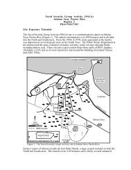
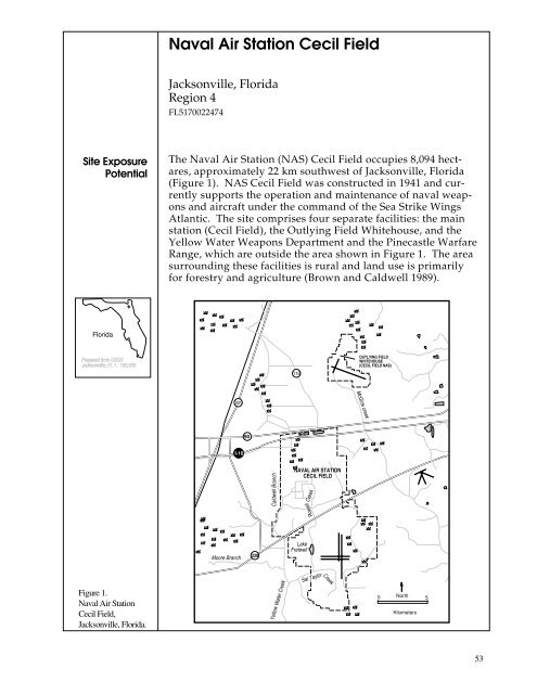
<strong>Naval</strong> <strong>Air</strong> <strong>Station</strong> <strong>Cecil</strong> <strong>Field</strong>Jacksonville, FloridaRegion 4FL5170022474Site ExposurePotentialThe <strong>Naval</strong> <strong>Air</strong> <strong>Station</strong> (NAS) <strong>Cecil</strong> <strong>Field</strong> occupies 8,094 hectares,approximately 22 km southwest of Jacksonville, Florida(Figure 1). NAS <strong>Cecil</strong> <strong>Field</strong> was constructed in 1941 and currentlysupports the operation and maintenance of naval weaponsand aircraft under the command of the Sea Strike WingsAtlantic. The site comprises four separate facilities: the mainstation (<strong>Cecil</strong> <strong>Field</strong>), the Outlying <strong>Field</strong> Whitehouse, and theYellow Water Weapons Department and the Pinecastle WarfareRange, which are outside the area shown in Figure 1. The areasurrounding these facilities is rural and land use is primarilyfor forestry and agriculture (Brown and Caldwell 1989).*FloridaPrepared from USGSJacksonville, FL 1 : 100,000119OUTLYING FIELDWHITEHOUSE(CECIL FIELD NAS)McGirts creek30190I-10Caldwell BranchNAVAL AIR STATIONCECIL FIELDRowell CreekMoore Branch228LakeFretwellFigure 1.<strong>Naval</strong> <strong>Air</strong> <strong>Station</strong><strong>Cecil</strong> <strong>Field</strong>,Jacksonville, Florida.Yellow Water CreekSal TaylorCreek0North 5Kilometers53
<strong>Naval</strong> <strong>Air</strong> <strong>Station</strong> <strong>Cecil</strong> <strong>Field</strong>Site ExposurePotential,cont.A variety of wastes have been generated as a result of activitiesat NAS <strong>Cecil</strong> <strong>Field</strong>. Oils, fuels, solvents, paints and thinners,pesticides, and sewage sludge have been buried or burned attwo on-site landfills and fourteen disposal areas. In addition,three sites have been used for ordnance disposal. Handling,storage, and disposal practices of these materials have contributedto contamination of groundwater, soil, and sediment atNAS <strong>Cecil</strong> <strong>Field</strong>.Surface water runoff from the site is conveyed to local streams,including Yellow Water Creek, Rowell Creek, and Sal TaylorCreek, by a system of storm sewers and unlined ditches. Theconfluence of Rowell and Sal Taylor creeks lies on the westernedge of the main station boundary. Sal Taylor continuessouthwest for 3 km before meeting Yellow Water Creek, thereceiving stream of all surface waters leaving the site. YellowWater Creek flows south from the Sal Taylor Creek tributaryfor 13 km to join Black Creek. Black Creek then flows southeastfor 27 km to the St. Johns River, which drains to the AtlanticOcean. The distance from the NAS <strong>Cecil</strong> <strong>Field</strong> to the St.Johns River is about 40 km.Three groundwater aquifers underlie the <strong>Cecil</strong> <strong>Field</strong> site: thesurficial aquifer, the secondary artesian aquifer, and theFloridan aquifer. The surficial aquifer is very shallow andexists in unconsolidated sand. This aquifer discharges tosurface water bodies and is the primary source of base flow formany streams in the area. The other aquifers are much deeperand are isolated from the surficial aquifer by low permeabilitygeological features.Both surface water and groundwater movement representpotential pathways of contamination from NAS <strong>Cecil</strong> <strong>Field</strong> tonearby streams. The majority of the contaminated areas identifiedat <strong>Cecil</strong> <strong>Field</strong> are close to Rowell Creek and Lake Fretwell.Both of these surface waters serve as the receiving points forgroundwater discharge and surface water flow emanatingfrom the sites. Known sites of contamination are also situatedalong the other creeks.Site-RelatedContaminationOnly contaminants at the main station of NAS <strong>Cecil</strong> <strong>Field</strong> andthe Yellow Water Weapons Department have been investi-54
<strong>Naval</strong> <strong>Air</strong> <strong>Station</strong> <strong>Cecil</strong> <strong>Field</strong>Site-RelatedContamination,cont.gated to date and are addressed here (Brown and Caldwell1989). Preliminary data indicate contaminated groundwater,surface water, soil, and sediment (Table 1; Brown andCaldwell 1989). The major contaminants of concern are cadmium,chromium, lead, and mercury, which were detected ingroundwater at high concentrations. Groundwater from thelandfills had some of the highest concentrations, and the mostfrequent occurrences of trace elements. Surface water collectedfrom a rubble disposal area had high concentrations ofmercury. Soil and sediment from a number of areas showedelevated concentrations of cadmium and lead. Low levels ofTable 1.Maximumconcentrations ofmajor contaminantsin the vicinity of thesite compared withapplicable screeninglevels.Water Soil SedimentGroundwaterWater AWQC 1 Average 2SurfaceSoil U.S. Soil Sediment ER-L 3µg/l µg/l µg/l mg/kg mg/kg mg/kg mg/kgINORGANIC SUBSTANCEScadmium 12 ND 1.1 + 17 0.06 20 5chromium 425 ND 11 16 100 9 80lead 573 ND 3.2 + 599 10 14 35mercury 0.8 0.3 0.012 NT 0.03 NT 0.15ORGANIC COMPOUNDSPCBs NT NT 0.014 0.58 NA ND 0.051: Ambient water quality criteria for the protection of aquatic organisms. Freshwater chroniccriteria presented (EPA 1986).2: Lindsay (1979)3: Effective range-low; the concentration representing the lowest 10 percentile value for thedata in which effects were observed or predicted in studies compiled by Long and Morgan(1990).+ Hardness-dependent criteria; 100 mg/l CaCO 3 used.NT Not analyzedND Not detected at method detection limit, detection limit not availablevolatile organic and semi-volatile organic compounds weredetected in groundwater and soil sampled from a number ofareas.NOAA TrustHabitats andSpeciesBlack Creek and the St. Johns River support numerous habitatsfor marine, estuarine, and anadromous fish and invertebrates,including several commercially important species andone endangered species (Table 2; Brown and Caldwell 1989;Wodall personal communication 1990). It is not known towhat extent these species utilize the tributary streams leadingfrom the site to Black Creek. Striped bass and blue crabspawn throughout Black Creek. The West Indian manatee, a55
<strong>Naval</strong> <strong>Air</strong> <strong>Station</strong> <strong>Cecil</strong> <strong>Field</strong>NOAA TrustHabitats andSpecies,cont.federally endangered species, occurs in the St. Johns River andhas been reported in Black Creek on several occasions, as farupstream as Middleburg, 16 km upstream of the site.Table 2.Species andhabitat use ofBlack Creek andthe lower St.Johns Riverestuary.Table available in hardcopyBlack Creek is a very popular area for recreational fisheriesand water-related sports, including swimming, boating, andwater skiing. Recreational fisheries in the creek include thosefor blue crab, striped bass, and red drum. Blue crab are alsofished commercially in Black Creek and eels are fished commerciallyin its lower reaches near the St. Johns River.The lower St. Johns River near the confluence of Black Creek istidally influenced and provides estuarine habitat for manymarine and estuarine species, including nursery grounds forshrimp, spotted seatrout, weakfish, spot, Atlantic croaker, andred drum (Brown and Caldwell 1989; Wodall personal communication1990).56
<strong>Naval</strong> <strong>Air</strong> <strong>Station</strong> <strong>Cecil</strong> <strong>Field</strong>ReferencesBrown and Caldwell. 1989. <strong>Naval</strong> <strong>Air</strong> <strong>Station</strong>, <strong>Cecil</strong> <strong>Field</strong>,Jacksonville, Florida. Draft Final RI/FS Work Plan. Charleston,South Carolina: Department of the Navy, Southern Division,<strong>Naval</strong> Facilities Engineering Command.Lindsay, W.L. 1979. Chemical Equilibria in Soils. New York:John Wiley & Sons. 449pp.Long, E.R., and L.G. Morgan. 1990. The potential for biologicaleffects of sediment-sorbed contaminants tested in theNational Status and Trends Program. NOAA TechnicalMemorandum NOS OMA-52. Seattle: Coastal and EstuarineAssessment Branch, NOAA. 175 pp.+ Appendices.U.S. Environmental Protection Agency. 1986. Quality Criteriafor Water. Washington, D.C.: Office of Water Regulationsand Standards, Criteria and Standards Division. EPA 440/5-86-001.Wodall, S., Environmental Investigator, Lake City RegionalOffice, Florida Fish and Game Commission, Lake City,Florida, personal communication, June 28, 1990.57