Old Track - Kerikeri - Far North District Council
Old Track - Kerikeri - Far North District Council
Old Track - Kerikeri - Far North District Council

You also want an ePaper? Increase the reach of your titles
YUMPU automatically turns print PDFs into web optimized ePapers that Google loves.
OLD TRACK: <strong>Kerikeri</strong> - Appletree Bay Path andLookoutOK01The type of track:Entrances/Exits:EntranceParking:Land Ownership:Maintainers:Sign posting:Promotion:Walking <strong>Track</strong>Off Rowsell LaneOn Rowsell Lane<strong>Far</strong> <strong>North</strong> <strong>District</strong> <strong>Council</strong><strong>Far</strong> <strong>North</strong> <strong>District</strong> <strong>Council</strong>NoneNoneLength: 20m?Difficulty:Activities:Facilities:Links:Description:The track used to descend steeply, with zigzags, down to the reserve in AppletreeBay.Picnicking and swimming at the beach, lookout at the view of the <strong>Kerikeri</strong> Inletfrom the lookout point.NonePossible links to the Ake Ake <strong>Track</strong>.Bush – tea tree, gorse, Manuka and undergrowth scrub at the lookout (see photobelow). The lookout is close to a burial ground/cemetery.
OLD TRACK: <strong>Kerikeri</strong> – Bings’ Esplanade <strong>Track</strong>OK02The type of track:Entrances/Exits:EntranceParking:Land Ownership:Maintainers:Sign posting:Promotion:Length:Difficulty:Activities:Facilities:Links:Description:Walking trackOn Golf Course Road and the <strong>Kerikeri</strong> Basin.At the Stone Store, at the bottom of Golf View Road, and at the access off LandingRoad up the hill from the Stone Store.Department of Conservation (?), <strong>Far</strong> <strong>North</strong> <strong>District</strong> <strong>Council</strong>, and some private land(one owner).None – would be easy to maintain.None“<strong>Kerikeri</strong> – Discover the lifestyle that makes <strong>Kerikeri</strong> Unique”2km?Relatively flat – used to be a bit muddy after wet weather.Walking, picnicking, runningNoneFairy Pools <strong>Track</strong>; Rainbow Falls <strong>Track</strong>; Koproripo Pa walk; Pa Road <strong>Track</strong>; HoneHeke <strong>Track</strong>An old track from the Stone Store hill, past the Booth Falls and the Fairy Pools tothe bottom of Golf View Road, across the river and return via Rainbow Falls Walk.Overgrown.
OLD TRACK: <strong>Kerikeri</strong> - Wairoa Falls WalkwayOK03The type of track:Entrances/Exits:EntranceParking:Land Ownership:Maintainers:Length:Difficulty:Activities:Facilities:Links:Description:Walking trackAt the Memorial Hall Bridge over the Wairoa Stream, Mill Lane area, Pa Road,Department of Conservation parking area across from Stone Store, Hone HekiRoad, Lanark Road.At all of the above, except for Pa Road.<strong>Far</strong> <strong>North</strong> <strong>District</strong> <strong>Council</strong> esplanade reserves.By property owners in the late 1960s, none at present.It is about 200 metres from the Memorial Hall to the falls. Some 150 metres furtheron is a set of shallow rapids and a second swimming hole. Total length – 2km.Steep descent beside the waterfall, gentle grades the rest of the way.Swimming, picnicking, walking, nature studiesHad benches in the 1920s and 30s – one still useable.Pa Road Bridge links to the Stone Store Basin, Kororipo Pa Walk and the RainbowFalls Walk, could also be a circular walk if Inlet Road or the Hone Heke <strong>Track</strong> areused for the return journey.Part of the walkway is lined with large Totara trees, and passes through a spectacularrock grotto on the east bank of the stream. It is part of the old Maori track toWaimate <strong>North</strong>. On May 3, 1845 it was used by the 400 strong detachment oftroops under Colonel Hulme to transport canon and supplies from Onewhero Bayto Waimate <strong>North</strong> in preparation for an attack on Hone Heke’s pa at Puketutu, onthe banks of Lake Omapere. In the 1920s and 30s the swimming hole was used byorchard workers and the walkway served as a promenade at weekends. It ismentioned in Fiona Kidman’s book ‘Mandarin Summer’.
OLD TRACK: Paihia - Nihonui Scenic Reserve <strong>Track</strong>sOP01The type of track:Entrances/Exits:EntranceParking:Land Ownership:Maintainers:Sign posting:Promotion:Length:Difficulty:Activities:Facilities:Links:Description:Walking trackDavis Crescent, Bay View Road (at the top), Moana Road, or central PaihiaThe Bluff, Davis Crescent, Blackbridge Road. New entry needed from Bay ViewRoad, Moana Road.<strong>Far</strong> <strong>North</strong> <strong>District</strong> <strong>Council</strong>NoneNone - The reserve name is published on maps.None± 1 kmEasy if cleared – steep in areas.Walking, picnics, panoramic views, historic Maori archaeological features, jogging,study of native ferns.There used to be a wooden seat at the highest point and lovely views across thebeach out to sea.Easy links to the Paihia – Opua Walkway and the Horotutu Scenic Reserve could beestablished.Overgrown – there is an old Pa site through which the track passes – or this sectioncould be bypassed if it is too steep. The Reserve also had a lookout position for thearmy during World War II.
OLD TRACK: Paihia - Opua Kauri WalkOP02The type of track:Entrances/Exits:EntranceParking:Land Ownership:Maintainers:Sign posting:Promotion:Length:Difficulty:Activities:Description:Short walkOff Oromahoe Road (to the south)On Oromahoe RoadDepartment of ConservationDepartment of ConservationNone to indicate where the path is; signposting along the walkway is still there.On early Department of Conservation – Bay of Islands maps.500 metres – 15 minutes.Mostly flat with small hills.Bush walk within large Kauri stand and pristine bush. No dogs allowed.Closed by the Department of Conservation because of unsafe track structures. It isdue to be reopened within the next tree years. This track affords easy access to largeKauri through well-established bush. The metalled track is still in good condition.This is an important walk for the community who have reported high usage ratesbefore it was closed.
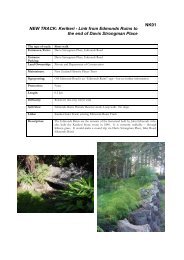
OLD TRACK: Paihia - Paihia Lookout Link to SchoolRoad and Bay View RoadOP03The type of track:Entrances/Exits:EntranceParking:Land Ownership:Maintainers:Sign posting:Promotion:Walking <strong>Track</strong>School Road and Bayview RoadSchool Road and Bayview Road<strong>Far</strong> <strong>North</strong> <strong>District</strong> <strong>Council</strong> and Department of ConservationDepartment of Conservation on existing part of the track.NoneNoneLength:Difficulty:Activities:Links:Description:Small hillsWalking, viewing scenery. No dogs.Could link the Nihonui Reserve <strong>Track</strong> to the Oromahoe Traverse via the PaihiaLookout and the Horotutu Reserve Lookout.Overgrown now, but was once well formed with nametags on large Totara and Rimutrees. The loop track behind the Paihia lookout follows a short ridge downhill, andthen traverses across the bottom of the hill before returning up to the junction withthe Oromahoe track. The rest of the track follows a ridge, all down hill, back to aproposed road, semi-formed, to Bayview Road.
OLD TRACK: Western Areas – MangapareruaWalkway (formerly <strong>Kerikeri</strong> Walkway)OW01The type of track: Tramping trackEntrances/Exits: Mangakaretu Road, SH 10EntranceParking:Land Ownership:Maintainers:Sign posting:Promotion:Length:Difficulty:Activities:Links:Description:On Mangakaretu Road and SH 10.PrivateNoneAll signs have been removedIt is shown on NZMS 260 and in Walkways books5 – 6 kmFlat to steepTramping, walkingPossible links to the <strong>Kerikeri</strong> River <strong>Track</strong> and to Puketi Forest.Overgrown and closed for some years. The track is marked on topographical mapnumber 260P05, Kaikohe.
OLD TRACK: Western Areas - The <strong>Old</strong> Cart Road<strong>Track</strong>OW02The type of track:Entrances/Exits:EntranceParking:Land Ownership:Maintainers:Sign posting:Promotion:Length:Difficulty:Activities:Description:Tramping track<strong>Kerikeri</strong> Airport and Waimate Mission House.At <strong>Kerikeri</strong> Airport and at Waimate Mission House.PrivateNoneNoneNone10 –12 kmUndulating, mostly farmland, some bush.Historical walk, rural walk.The original road went from Kemp House, via <strong>Kerikeri</strong> Road and Wairoa Road tothe Waimate Mission House. It was the first vehicular access road formed as apermanent right of way in New Zealand, and included the first permanent vehicularbridge. The Mission House at Waimate <strong>North</strong> is the only survivor of three missionhouses built in 1832. There is about 2km of metalled track formed on an existingpaper road, but the rest is on private farmland. Historic spots could be signposteden route – for example – the location of bridges over streams (especially theWaitangi River Bridge) and the location of a cairn where a missionary’s son waskilled as a result of a fall off his horse.