Medieval And Colonial Capital Cities Of <strong>Delhi</strong>DESCRIPTIONhis French allies. It left the British India Company in control of Bengal and as the major military and politicalpower in India. In the following decades it gradually increased the size of the territories under its control, eitherruling directly or via local rulers under the threat of force from the British Indian Army. British India eventuallygrew into the empire's most valuable possession, "the Jewel in the Crown"; covering a territory greater thanthat of the Roman Empire, it was the most important source of Britain's strength, defining its status as theworld's greatest power. By this time, Mughal power was severely limited. The last emperor, Bahadur Shah II hadauthority over only the city of Shahjahanabad. He supported the Indian Rebellion of 1857 and was overthrown bythe British, and the last remnants of the Mughal Empire were taken over by the British Raj.Thereafter, the British government assumed direct control over India. This was the 2 nd event in history thatshaped the Historic urbanscape of <strong>Delhi</strong> ‐ the high point of the British Rule. In the period known as the British Raj,where an appointed Governor‐General administered India and Queen Victoria was crowned the Empress of India.Calcutta was the capital of India until December 1911 during the British Raj. During the early 1900s, a proposalwas made to the British administration to shift the capital of the British Indian Empire (as it was officially called)from Calcutta to <strong>Delhi</strong>. Unlike Calcutta, which was located on the eastern coast of India, <strong>Delhi</strong> was located innorthern India and the Government of British India felt that it would be easier to administer India from <strong>Delhi</strong>rather than from Calcutta. On 12 December 1911, during the <strong>Delhi</strong> Durbar, George V, the then Emperor of India,along with Queen Mary, his Consort, made the announcement that the capital of the Raj was to be shiftedfrom Calcutta to <strong>Delhi</strong>. A new capital city was built adjoining Shahjahanabad, the Mughal Capital <strong>City</strong> and an olderDinapanah citadel, which was also considered the site of Indraprastha, the ancient region of <strong>Delhi</strong>. New <strong>Delhi</strong>,planned in 1912‐13, and inaugurated in 1931, as the capital of the erstwhile British Empire in India, is evidence ofthe extraordinary fusion of two dominant themes of the early twentieth century city planning‐ the <strong>City</strong>Beautiful (vistas) and the Garden city (verdure) Movements.31‐07‐2012 INTACH, <strong>Delhi</strong> Chapter 24
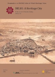
Medieval And Colonial Capital Cities Of <strong>Delhi</strong>DESCRIPTIONDESIGN OF THE MUGHAL IMPERIAL CITY, SHAHJAHANABADThe siteWhen the Mughal Emperor Shahjahan, chose the right bank of the River Yamuna in <strong>Delhi</strong> for his new city, he wasnot working on a clean slate. <strong>Delhi</strong>, even in the years when it was not the capital of the Mughals, had continuedto be one of the most important centres of trade in north India. Here, the overland trade from the northconverged with the riverine trade of the Gangetic plain further south. Two major arteries of that trade – the RiverYamuna, and the Grand Trunk road, converged in precisely this part of the city.Beside the river at this point, was an ancient landmark – Nigambodh Ghat. A site sacred to Hindus, this point hadsteps leading down to the water to enable bathing. Nearby was also the landing area for boats, and importantmarts such as Daryaganj – literally ‘the mart by the river’. In the mid‐sixteenth century, Islam Shah Sur, the thenemperor, had built the small fortress of Salimgarh beside the river at this point, no doubt to provide security andstrategic control over the all‐important trade route. The main highway from the north, the Grand Trunk Roadalso passed quite close to this area and beside it were some flourishing settlements, serviced by markets,manufacturing areas, wells, gardens, and places of worship.The planShahjahan had set his architect‐planners and astrologers to determining the site and plan of the new city, andtook a personal interest in the layout. Various theoretical and practical considerations went into the the planningof the city:Firstly, the plan of Shahjahanabad was influenced by ancient Hindu texts as well as medieval Persian traditions.The Manasara, one of the Hindu texts on architecture collectively called the Vastu Shastra, prescribes a bowshapedform for a city on a river, and this is the plan that Shahjahanabad roughly followed. The eastern wall ofthe city, parallel to the river, could be viewed as the string of the bow, and parallel to this ran the main northsouthstreet, linking the Kashmir gate in the north with the <strong>Delhi</strong> gate in the south. The other main street of thecity could be viewed as the arrow placed in the bow, running from the main entrance to the Red Fort (which waslocated approximately midway along the eastern wall of the city) westwards to the Fatehpuri Mosque. Thepalace complex therefore stood at the junction of the main north‐south and east‐west axes, where in the Hindutext a temple would have been located.In this arrangement the main congregational mosque of the city, the Jama Masjid, was located on a height (anatural rise called Bhojla Pahad) fairly close to the palace complex, but off‐centre with regard to the main streets.In terms of Persian texts such as the Rasa’il‐e‐Ikhwan‐us‐Safa, which viewed ideal city plans as mirroring theanatomy of man, the Jama Masjid would be the heart in relation to the Red Fort which was the head, and theeast‐west street which was the backbone. The plan of Shahjahanabad therefore clearly shows both Hindu andPersian Sufi influences, in keeping with the long <strong>Delhi</strong> tradition of synthesis, and the general Mughal policy ofliberality and inclusion vis a vis Hindu subjects.Another important consideration was the showcasing of imperial grandeur. The buildings, markets, mosques andstreets had to compete with the best in the Islamic world, particularly Iran, from which many of the standards forcultural excellence were drawn. Thus Shahjahan’s own chroniclers compared Shahjahanabad favourably toIsfahan. Imperial grandeur could be expressed in different ways. Monumental buildings were commissioned bythe emperor – the Red Fort and its palaces, the Jama Masjid or congregational mosque of the city. Three of hiswives – Fatehpuri begam, Sarhindi bagam, and Akbarabadi begam, built major mosques in prominent positions.The main streets leading from the emperor’s palace complex were broad avenues, well suited to the pomp andceremony of the emperor’s processions, as he went to the Jama Masjid to join in the prayers (along a broadceremonial way called Khas Bazar), or to the Eidgah west of the city on the major Islamic festivals, or as he leftthe city through one of the gates for a longer journey. The prosperity of the realm found expression in the rich31‐07‐2012 INTACH, <strong>Delhi</strong> Chapter 25