2.3 Mapping Earth's Physical Features canyon Physical ... - InforMNs
2.3 Mapping Earth's Physical Features canyon Physical ... - InforMNs
2.3 Mapping Earth's Physical Features canyon Physical ... - InforMNs

Create successful ePaper yourself
Turn your PDF publications into a flip-book with our unique Google optimized e-Paper software.
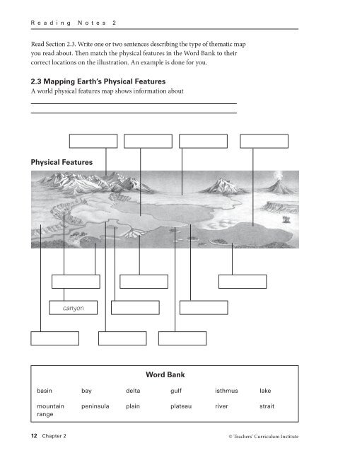
R e a d i n g N o t e s 2Read Section <strong>2.3</strong>. Write one or two sentences describing the type of thematic mapyou read about. Then match the physical features in the Word Bank to theircorrect locations on the illustration. An example is done for you.<strong>2.3</strong> <strong>Mapping</strong> Earth’s <strong>Physical</strong> <strong>Features</strong>A world physical features map shows information about<strong>Physical</strong> <strong>Features</strong><strong>canyon</strong>Word Bankbasin bay delta gulf isthmus lakemountainrangepeninsula plain plateau river strait12 Chapter 2© Teachers’ Curriculum Institute
R e a d i n g N o t e s 2Read Section 2.4. Write one or two sentences describing the type of thematicmap you read about. Then complete the list of climate zones by filling in themissing pieces. Each entry should have a key term, an icon, and a definition.2.4 Hot, Cold, Wet, Dry: Earth’s ClimatesA world climate map shows information aboutClimate Zonesice cap: very cold all year withpermanent ice and snowMediterranean: warm all yearwith dry summers and short,rainy winters0ºF 50ºFtundra:arid: hot and dry all year withvery little rain0ºF60ºF__________________: cold,snowy winters and cool, rainysummers30ºF 75ºFsemiarid:marine west coast: warmsummers, cool winters, andrainfall all year60ºF__________________: hot allyear with rainy and dry seasons15ºF70ºF__________________: warm,rainy summers and cool,snowy winters80ºFtropical wet:40ºF80ºF__________________: hot, rainysummers and mild winters withsome rainhighlands:© Teachers’ Curriculum Institute A Spatial Way of Thinking 13
R e a d i n g N o t e s 2Read Section 2.5. Write one or two sentences describing the type of thematicmap you read about. Then complete the list of vegetation zones by filling in themissing pieces. Each entry should have a key term, an icon, and a definition.2.5 Trees and Other Plants: Earth’s VegetationA world vegetation map shows information aboutVegetation Zonesice cap:__________________: smalltrees and bushes adapted to aMedi terranean climatetundra: treeless plain withgrasses, mosses, and scrubsadapted to a cold climate__________________: trees withbroad, flat leaves that are shedbefore winterdesert: arid region with fewplants__________________: a mix ofconiferous and deciduous treesdesert scrub:coniferous forest:temperate grassland:broadleaf evergreen forest:tall trees with large leaves thatremain green all year__________________: grassesand scattered trees adapted to atropical wet and dry climatehighlands: vegetation varies withlatitude and elevation14 Chapter 2© Teachers’ Curriculum Institute
R e a d i n g N o t e s 2Read Section 2.6. Write one or two sentences describing the type of thematicmap you read about. Then complete the list of population densities by filling inthe missing pieces. Each entry should have a key term, an icon, and a definition.2.6 Where People Live: Population DensityA world population density map shows information aboutPopulation Densitymore than 250 people per square mile: an average of morethan 250 people live in every square mile125–250 people per square mile:________________________________: an average of 25 to125 people live in every square mile________________________________: an average of 2 to25 people live in every square milefewer than 2 people per square mile:© Teachers’ Curriculum Institute A Spatial Way of Thinking 15
R e a d i n g N o t e s 2Read Section 2.7. Write one or two sentences describing the type of thematicmap you read about. Then complete the list of economic activities by filling inthe missing pieces. Each entry should have a key term, an icon, and a definition.2.7 Economic Activity: Land and ResourcesA world economic activity map shows information aboutEconomic Activityhunting and gathering: peoplehunt animals and gather plantsfor their food__________________: usingtrees to make homes, furniture,and papersubsistence farming:trade and manufacturing:buying and selling goods;turning natural resources intothings to sell__________________: farmersraise crops or livestock to selllivestock raising:nomadic herding:commercial fishing: catchingfish in oceans, lakes, and rivers16 Chapter 2© Teachers’ Curriculum Institute
R e a d i n g N o t e s 2Read Section 2.8. Write one or two sentences describing the type of thematicmap you read about. Then color and label each of the seven world regions.2.8 Organizing Earth’s Surface: RegionsA world regions map shows information aboutARCTICOCEANATLANTICOCEANPACIFICOCEANPACIFICOCEAN0 1,5003,000 miles0 3,000 kilometersRobinson projectionWNSEINDIANOCEAN© Teachers’ Curriculum InstituteA Spatial Way of Thinking 17