WATER POVERTY IN THE NORTHEASTERN HILL REGION (INDIA)
WATER POVERTY IN THE NORTHEASTERN HILL REGION (INDIA) WATER POVERTY IN THE NORTHEASTERN HILL REGION (INDIA)
WATER POVERTY IN THE NORTHEASTERN HILL REGION (INDIA): POTENTIAL ALLEVIATION THROUGH MULTIPLE-USE WATER SYSTEMSTable 3: Details of Mon district (Nagaland, India) at a glanceArea 1,786 km 2District headquartersMon (Altitude = 897.64 m above sea level)Population 2,59,604 (Provisional Census 2001)Density of population 145 per km 2 (Provisional Census 2001)Sex ratio881:1000 (Females per 1000 males)Literacy rate 42.25 % (Male: 46.7 %; Female : 37.1%)Decennial growth of population 73.42 % (Provisional Census 2001)Average annual rainfallAverage temperatureHighest peakImportant rivers/rivuletsInternational trade centreRural development (RD) blocksNumber of hospitals (Govt.-run)Ranges from 2000 mm to 3000 mm24.4 degree CelsiusShawot (Altitude = 2,414 m above sea level)Dikhu Tizit, Tehok, Tekang, Tapi, Kaimang, Yityong, Telangsao, etc.01 (Located at Longwa – 59 km from Mon district headquarters)06 (Mon, Chen, Wakching, Tizit, Tobu, Phomching)02 (Mon: 50-bedded, Wakching: 06-bedded)Number of recognised villages 113Number of schools 194Number of colleges01 (Wangkhao Govt. College, Mon)Mon town. The village like many other villages in Mon district is largely an unexplored area having a100% tribal population. Developmental activities have been undertaken only in the last few years inthe village.3.4. Socio-Economic Characteristics of Village Lampong SheanghahThe place where Lampong Sheanghah is presently located was a very thick forest even in the late 1800’s.There was no human settlement here. The whole area was owned by the Konyak tribe which was settledin the far off village of Mon. The first settlement happened around the year 1892 when 18 householdssettled here. The present population in the village are mostly descendants of these 18 families.3.4.1. History about Konyaks TribeThe Konyaks were a feared tribe since they had the reputation of being head hunters, but all this changeddrastically with the advent of Christianity and the entry of missionaries in the area. The missionariesworked to bring the people towards the mainstream society. Due to their effort, the population in thevillage and surrounding areas is exclusively Christian. Since first introducing education, the churcheshave continued to contribute very significantly to education, health and human resource building in12
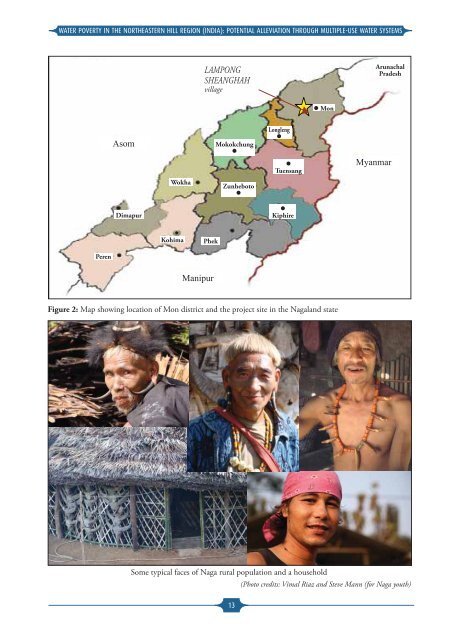
WATER POVERTY IN THE NORTHEASTERN HILL REGION (INDIA): POTENTIAL ALLEVIATION THROUGH MULTIPLE-USE WATER SYSTEMSLAMPONGSHEANGHAHvillageArunachalPradesh MonAsomMokokchungLonglengTuensangMyanmarWokhaZunhebotoDimapurKiphireKohimaPhekPerenManipurFigure 2: Map showing location of Mon district and the project site in the Nagaland stateSome typical faces of Naga rural population and a household(Photo credits: Vimal Riaz and Steve Mann (for Naga youth)13
- Page 5: WATER POVERTY IN THE NORTHEASTERN H
- Page 9 and 10: WATER POVERTY IN THE NORTHEASTERN H
- Page 11 and 12: WATER POVERTY IN THE NORTHEASTERN H
- Page 13: WATER POVERTY IN THE NORTHEASTERN H
- Page 17 and 18: WATER POVERTY IN THE NORTHEASTERN H
- Page 19 and 20: WATER POVERTY IN THE NORTHEASTERN H
- Page 21 and 22: WATER POVERTY IN THE NORTHEASTERN H
- Page 23 and 24: WATER POVERTY IN THE NORTHEASTERN H
- Page 25 and 26: WATER POVERTY IN THE NORTHEASTERN H
- Page 27 and 28: WATER POVERTY IN THE NORTHEASTERN H
- Page 29 and 30: WATER POVERTY IN THE NORTHEASTERN H
- Page 31 and 32: WATER POVERTY IN THE NORTHEASTERN H
- Page 33 and 34: WATER POVERTY IN THE NORTHEASTERN H
- Page 35 and 36: WATER POVERTY IN THE NORTHEASTERN H
- Page 37 and 38: WATER POVERTY IN THE NORTHEASTERN H
- Page 39 and 40: WATER POVERTY IN THE NORTHEASTERN H
- Page 41 and 42: WATER POVERTY IN THE NORTHEASTERN H
- Page 43 and 44: WATER POVERTY IN THE NORTHEASTERN H
- Page 45 and 46: WATER POVERTY IN THE NORTHEASTERN H
<strong>WATER</strong> <strong>POVERTY</strong> <strong>IN</strong> <strong>THE</strong> NOR<strong>THE</strong>ASTERN <strong>HILL</strong> <strong>REGION</strong> (<strong>IN</strong>DIA): POTENTIAL ALLEVIATION THROUGH MULTIPLE-USE <strong>WATER</strong> SYSTEMSLAMPONGSHEANGHAHvillageArunachalPradesh MonAsomMokokchungLonglengTuensangMyanmarWokhaZunhebotoDimapurKiphireKohimaPhekPerenManipurFigure 2: Map showing location of Mon district and the project site in the Nagaland stateSome typical faces of Naga rural population and a household(Photo credits: Vimal Riaz and Steve Mann (for Naga youth)13


