V103-113 Vector compass.pdf
V103-113 Vector compass.pdf
V103-113 Vector compass.pdf

You also want an ePaper? Increase the reach of your titles
YUMPU automatically turns print PDFs into web optimized ePapers that Google loves.
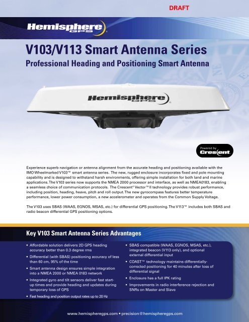
DRAFT<strong>V103</strong>/V<strong>113</strong> Smart Antenna SeriesProfessional Heading and Positioning Smart AntennaExperience superb navigation or antenna alignment from the accurate heading and positioning available with theIMO Wheelmarked <strong>V103</strong> smart antenna series. The new, rugged enclosure incorporates fixed and pole mountingcapability and is designed to withstand harsh environments, offering simple installation for both land and marineapplications. The <strong>V103</strong> series now supports the NMEA 2000 processor and interface, as well as NMEA0183, enablinga seamless choice of communication protocols. The Crescent ® <strong>Vector</strong>II technology provides robust performance,including position, heading, heave, pitch and roll output. The new gyro<strong>compass</strong> features better temperatureperformance, lower power consumption, a new accelerometer and operates from the Common Supply Voltage.The <strong>V103</strong> uses SBAS (WAAS, EGNOS, MSAS, etc.) for differential GPS positioning. The V<strong>113</strong> includes both SBAS andradio beacon differential GPS positioning options.Key <strong>V103</strong> Smart Antenna Series Advantages• Affordable solution delivers 2D GPS headingaccuracy better than 0.3 degree rms• Differential (with SBAS) positioning accuracy of lessthan 60 cm, 95% of the time• Smart antenna design ensures simple integrationinto a NMEA 2000 or NMEA 0183 network• Integrated gyro and tilt sensors deliver fast startuptimes and provide heading and updates duringtemporary loss of GPS• Fast heading and position output rates up to 20 Hz• SBAS compatible (WAAS, EGNOS, MSAS, etc.),integrated beacon (V<strong>113</strong> only), and optionalexternal differential input• COAST technology maintains differentiallycorrectedpositioning for 40 minutes after loss ofdifferential signal• Enclosure has a full IPK rating• Improvements in radio interference rejection andSNRs on Master and Slavewww.hemispheregps.com • precision@hemispheregps.com
<strong>V103</strong>/V<strong>113</strong> Smart Antenna SeriesGPS Sensor SpecificationsReceiver Type: L1, C/A code, with carrier phase smoothingChannels:Two 12-channel, parallel tracking(Two 10-channel when tracking SBAS)GPS Sensitivity: -142dBmSBAS Tracking: 2-channel, parallel trackingUpdate Rate:Standard 20 Hz (position and heading)Horizontal Accuracy: < 0.6 m 95% confidence (DGPS 1 )< 2.5 m 95% confidence(autonomous, no SA 2 )Heading Accuracy: < 0.30˚ rmsPitch/Roll Accuracy: < 1.0˚ rmsHeave Accuracy: 30 cm 5Timing (1PPS) Accuracy: 50 nsRate of Turn:90˚/s maximumCompass SafeDistance: 125 cm (49.2 in) 4Cold Start:< 60 s (no almanac or RTC)Warm Start:< 20 s typical (almanac and RTC)Hot Start:< 1 s typical (almanac, RTC and position)Heading Fix:< 10 s typical (valid position)Maximum Speed: 1,850 mph (999 kts)Maximum Altitude:18,288 m (60,0000 ft)Beacon Sensor Specifications (V<strong>113</strong> version)Channels:2-channel, parallel trackingFrequency Range: 283.5 to 325 kHzOperating Modes: Manual, automatic and databaseCompliance:IEC 61108-4 beacon standardHeading Warning I/O:Open relay system indicates invalidheadingEnvironmentalOperating Temperature: -30°C to + 70°C (-22°F to + 158°F)Storage Temperature: -40°C to + 85°C (-40°F to + 185°F)Humidity:95% non-condensingVibration: IEC 60945EMC:FCC Part 15, Subpart B, CISPR22, CEIMO Wheelmark Certification: YesPowerInput Voltage:6 to 36 VDCPower Consumption: <strong>V103</strong> V<strong>113</strong>3 W nominal 3.3 W nominalCurrent Consumption: <strong>V103</strong> V<strong>113</strong>320 mA @ 9 VDC 350 mA @ 9 VDC240 mA @ 12 VDC 265 mA @ 12 VDC180 mA @ 16 VDC 200 mA @ 16 VDCPower Isolation:Isolated to enclosureReverse Polarity Protection:MechanicalDimensions:Yes66.3 L x 20.9 W x 14.6 H (cm)26.1 L x 8.3 W x 5.8 H (in)Weight: <strong>V103</strong> V<strong>113</strong>2.1 kg (4.6 lb) 2.4 kg (5.4 lb)Power/Data Connector:18-pin, environmentally sealedCommunicationsSerial Ports:1 full-duplex RS-232; 1 full-duplexRS-422 and 1 half-duplex RS-422 (Tx only)Baud Rates: 4800 - 38400Correction I/O Protocol: RTCM SC-104, L-Dif TM 3Data I/O Protocol: NMEA 0183, Crescent binary 3 , L-Dif TM 3Timing Output:1PPS CMOS, active low, falling edge sync,10 k, 10pF loadAiding DevicesGyro:Tilt Sensors:Provides smooth heading, fast headingreacquisition and reliable < 1˚ perminute heading for periods up to 3minutes when loss of GPS has occurredProvide pitch and roll data and assist infast start-up and reacquisition ofheading solution.Authorized Distributor:HEMISPHERE GPS4110 - 9th Street S.E.Calgary, AB T2G 3C4Canada1 Depends on multipath environment, number of satellites in view,satellite geometry, baseline length (for local services), and ionosphericactivity2 Depends on multipath environment, number of satellites in viewand satellite geometry3 Hemisphere GPS proprietary45 This is the minimum safe distance measured when the productis placed in the vicinity of the steering magnetic <strong>compass</strong>. The ISO694 defines “vicinity” relative to the <strong>compass</strong> as within 5 m (16.4 ft)separation.6 Based on a 40 second time constantPhone: 403.259.3311Fax: 403.259.8866precision@hemispheregps.comwww.hemispheregps.comCopyright 2011 Hemisphere GPS. All rights reserved. Specifications subject to change without notice.Hemisphere GPS, Hemisphere GPS logo, Crescent, Crescent logo, <strong>V103</strong>, V<strong>113</strong>, L-Dif and COAST are trademarks of Hemisphere GPS.Rev. 8/11