Thematic Maps of the Danube River Basin - ICPDR
Thematic Maps of the Danube River Basin - ICPDR
Thematic Maps of the Danube River Basin - ICPDR

You also want an ePaper? Increase the reach of your titles
YUMPU automatically turns print PDFs into web optimized ePapers that Google loves.
32 <strong>Danube</strong> Pollution Reduction Programme<br />
3.4. Slovakia<br />
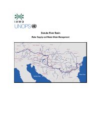
The Slovak part <strong>of</strong> <strong>the</strong> <strong>Danube</strong> <strong>Basin</strong> is divided into four Sub-river <strong>Basin</strong> Areas with ten Sub-<br />
<strong>Basin</strong>s, representing nearly 96% (49,014 km²) <strong>of</strong> <strong>the</strong> total area <strong>of</strong> <strong>the</strong> Slovak Republic.<br />
The Slovak part <strong>of</strong> <strong>the</strong> <strong>River</strong> <strong>Basin</strong> has borders with Austria, Czechia, Poland, Ukraine and<br />
Hungary.<br />
5. Morava - <strong>Danube</strong> Sub-river <strong>Basin</strong> Area (SK)<br />
This Sub-river <strong>Basin</strong> Area consists <strong>of</strong> <strong>the</strong> Morava, <strong>Danube</strong> and <strong>the</strong> Small <strong>Danube</strong> <strong>River</strong> sub-basins.<br />
With its 3,395 km², this is <strong>the</strong> smallest Sub-river <strong>Basin</strong> Area <strong>of</strong> <strong>the</strong> Slovak Republic.<br />
The two main rivers are <strong>the</strong> <strong>Danube</strong> and <strong>the</strong> Morava. The relief <strong>of</strong> <strong>the</strong> Morava mainly consists <strong>of</strong><br />
lowlands and valleys; it includes some <strong>of</strong> <strong>the</strong> largest floodplain meadws in Central Europe.<br />
The region around <strong>the</strong> Small <strong>Danube</strong> (former side-arm) is most fertile, agricultural land. The<br />
<strong>Danube</strong> part includes large floodplain forests which, since 1992, are affected by <strong>the</strong> Gabcikovo<br />
hydropower complex.<br />
Without counting <strong>the</strong> capital Bratislava (451,000inhabitants), <strong>the</strong> density <strong>of</strong> 125 inhabitants/km² is<br />
still <strong>the</strong> highest in <strong>the</strong> country. With one medium and one „low priority“ industrial hot spots, <strong>the</strong><br />
region lies in <strong>the</strong> average <strong>of</strong> <strong>the</strong> Slovak Republic.<br />
The area has borders with <strong>the</strong> Czech Republic, Poland and Austria.<br />
6. Váh Sub-river <strong>Basin</strong> Area (SK)<br />
The Váh Sub-river <strong>Basin</strong> Area is created by <strong>the</strong> two sub-basins <strong>of</strong> <strong>the</strong> Váh and Nitra rivers and is<br />
situated in <strong>the</strong> nor<strong>the</strong>ast <strong>of</strong> <strong>the</strong> country.<br />
The Váh <strong>River</strong> is situated in a mountainous area, characterised by a very low population density.<br />
The sub-basin represents one quarter <strong>of</strong> <strong>the</strong> total territory <strong>of</strong> Slovakia (biggest Sub-river <strong>Basin</strong> Area<br />
<strong>of</strong> Slovakia) and with its discharge <strong>of</strong> 152 m³/sec it is Slovakia’s biggest river. Although <strong>the</strong><br />
population rate is quite low in this region we find five municipal and two industrial hot spots.<br />
Industrial activities are represented with chemical, heavy and food-processing industries. This area<br />
has <strong>the</strong> highest rate <strong>of</strong> employment in <strong>the</strong> industrial sector.<br />
The Nitra <strong>River</strong> rises on <strong>the</strong> Sou<strong>the</strong>rn slopes <strong>of</strong> Malá Fatra mountains (Small Carpathians) and<br />
confluences with <strong>the</strong> Vah <strong>River</strong> just before running into <strong>the</strong> <strong>Danube</strong>.<br />
The area has borders with <strong>the</strong> Czech Republic and Poland.<br />
7. Hron Sub-river <strong>Basin</strong> Area (SK)<br />
This area is in <strong>the</strong> Sou<strong>the</strong>rn part <strong>of</strong> central Slovakia and includes <strong>the</strong> Hron, Ipel and Slaná subbasins.<br />
The Hron <strong>River</strong> itself rises in <strong>the</strong> Slovenské Rudohorie mountains at an elevation <strong>of</strong> 934 meters and<br />
flows into <strong>the</strong> <strong>Danube</strong> <strong>River</strong> at 102 metres. The Hron Sub-river <strong>Basin</strong> Area is much more<br />
industrialised (mainly heavy industries) than <strong>the</strong> rivers Ipel and Slaná (32% urbanised) where<br />
agricultural production prevails.<br />
The Ipel river is affected by food industries. Three industrial Hot Spots („low priority“) can be<br />
found along <strong>the</strong> Hron. The area has only borders with Hungary.