Thematic Maps of the Danube River Basin - ICPDR
Thematic Maps of the Danube River Basin - ICPDR
Thematic Maps of the Danube River Basin - ICPDR

Create successful ePaper yourself
Turn your PDF publications into a flip-book with our unique Google optimized e-Paper software.
1. Introduction<br />
The following “<strong>Thematic</strong> <strong>Maps</strong> <strong>of</strong> <strong>the</strong> <strong>Danube</strong> <strong>River</strong> <strong>Basin</strong>” Report tries to give an overview <strong>of</strong> a<br />
proposed new sub-division developed for <strong>the</strong> PRP-Transboundary Analysis. This Report uses<br />
information from <strong>the</strong> National Reviews, adding socio-economic and ecological information, results<br />
from Water Quality Data and National Planning Reports (1998) and from questionnaires (landuse,<br />
agriculture, population, river characteristics), circulated in February and June 1999.<br />
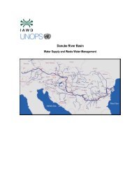
In a new planning approach, <strong>the</strong> entire <strong>Danube</strong> <strong>Basin</strong> was nationally sub-divided into so-called<br />
“Sub-river <strong>Basin</strong> Areas”, i.e. aggregated, geographical units <strong>of</strong> several similar hydrographic parts<br />
(basins <strong>of</strong> mostly <strong>the</strong> <strong>Danube</strong>’s first-order tributaries); <strong>the</strong>se were discussed and agreed at <strong>the</strong><br />
National Planning Workshops. There are one to four <strong>of</strong> such Areas per country and 32 Sub-river<br />
<strong>Basin</strong> Areas altoge<strong>the</strong>r in <strong>the</strong> <strong>Danube</strong> basin, as shown on Map 3. This allows an easier approach for<br />
<strong>the</strong> national assessment <strong>of</strong> environmental problems and <strong>the</strong>ir solutions. A summary text briefly<br />
describes <strong>the</strong> character <strong>of</strong> each Sub-river <strong>Basin</strong> Area (national view), <strong>the</strong> Annex fur<strong>the</strong>r gives<br />
comparative charts for each <strong>Danube</strong> basin country and its Sub-river <strong>Basin</strong> Areas, regarding <strong>the</strong><br />
following socio-economic issues:<br />
� Population Density (excluding <strong>the</strong> main cities): Map 4<br />
� Land Use: Map 5<br />
� Agriculture (lifestock, fertiliser consumption and production <strong>of</strong> three main crops):<br />
<strong>Maps</strong> 6 and 7.<br />
� Hot Spots: <strong>Maps</strong> 8 and 9<br />
In a second step, <strong>the</strong>se areas were looked at from a transboundary perspective and fur<strong>the</strong>r<br />
aggregated, resulting in 15 – mostly transboundary - “Sub-<strong>River</strong> <strong>Basin</strong>s” which were discussed<br />
and agreed at <strong>the</strong> Transboundary Workshop in Hernstein (Map 2). Objective was to better address<br />
local and national river basin management needs at <strong>the</strong> <strong>Danube</strong> basin level; as stipulated i.a. by <strong>the</strong><br />
new EU Water Policy Directive (asking for transboundary “river basin districts”). This was<br />
achieved by reducing <strong>the</strong>ir number and by connecting transboundary hydrographic regions (e.g.<br />
catchment areas). The text chapter „Sub-<strong>River</strong> <strong>Basin</strong>s“ briefly describes <strong>the</strong> new aggregated regions<br />
(basic geographical and typical landscape characteristics, climate, most important economic data<br />
and environmental problems).<br />
The third step was <strong>the</strong> identification <strong>of</strong> “Significant Impact Areas” which are most intensively<br />
affected by pollution and which are valuable from an environmental and/or conservation point <strong>of</strong><br />
view. This report lists and describes all 51 SIAs. The overlay <strong>of</strong> Hot Spots, SIAs and Wetlands<br />
(<strong>Maps</strong> 10 and 11) facilitated <strong>the</strong> needed selection and ranking <strong>of</strong> pollution reduction projects within<br />
<strong>the</strong> PRP.<br />
In a fourth step, Geomorphological Regions (Map 1) and Major Hydraulic Structures <strong>of</strong> <strong>Danube</strong><br />
<strong>Basin</strong> <strong>River</strong>s (Map 12) were identified.<br />
There are some differences in <strong>the</strong> information given which should be briefly addressed before:<br />
Especially for <strong>the</strong> <strong>the</strong>me “Land Use” (Map 5), <strong>the</strong> provided data proved to be insufficient to cover<br />
<strong>the</strong> needed level <strong>of</strong> Sub-river <strong>Basin</strong> Areas. Therefore, <strong>the</strong> data given in this report are based on <strong>the</strong><br />
CORINE geographical information system and may vary in a small degree from <strong>the</strong> national data<br />
given in some <strong>of</strong> <strong>the</strong> National Reports or <strong>the</strong> questionaires.<br />
For Agriculture (see maps 6 and 7), it was agreed with <strong>the</strong> <strong>Danube</strong> PCU to concentrate on few<br />
indicators (absolute and relative values for lifestocks and fertiliser consumption, <strong>the</strong> three main<br />
agricultural products). Due to <strong>the</strong> difference in detail information, only national data were<br />
compared.