alive and well - Geological Society of Australia
alive and well - Geological Society of Australia
alive and well - Geological Society of Australia

You also want an ePaper? Increase the reach of your titles
YUMPU automatically turns print PDFs into web optimized ePapers that Google loves.
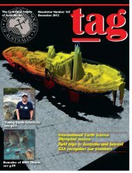
Andrew Hunter undertaking a cliff inspection at Warragamba Dam in 2011.Engineering geologists remain closely involved in working on dams. Upgradesto spillways on a number <strong>of</strong> dams along the east coast were a significant source<strong>of</strong> work over the past decade. One <strong>of</strong> these featured heavily in the press lastyear as fuse plugs in the auxiliary spillway at the Wivenhoe Dam came closeto triggering during last year’s Brisbane floods.The field <strong>of</strong> l<strong>and</strong>slide risk assessment, a core engineering geologytask, has experienced significant change since the late 1990swhen <strong>Australia</strong> experienced its worst l<strong>and</strong>slides in terms <strong>of</strong> deathsat Gracetown <strong>and</strong> Thredbo. The AGS was <strong>and</strong> continues to be atthe forefront <strong>of</strong> developing guidelines for l<strong>and</strong>slide risk managementin <strong>Australia</strong> (see http://lrm.australiangeomechanics.org/).The development <strong>of</strong> l<strong>and</strong>slide inventories <strong>and</strong> susceptibilityzoning studies is becoming widespread. The NSW Roads <strong>and</strong>Maritime Services has been a world leader in developing a system<strong>of</strong> qualitative slope risk assessment for its road system, which isrecognised internationally <strong>and</strong> is currently being adopted by anumber <strong>of</strong> <strong>Australia</strong>n States. Methods for investigating, monitoring<strong>and</strong> managing l<strong>and</strong>slides have also undergoneconsiderable change, with improvements in ground <strong>and</strong> structuralmonitoring capabilities, communication technology <strong>and</strong> <strong>of</strong> coursethe internet now allowing the development <strong>of</strong> real-timemonitoring <strong>of</strong> structures, subsurface <strong>and</strong> surface groundmovements, groundwater <strong>and</strong> rainfall. The continuous monitoringrecord this allows is <strong>of</strong> huge benefit to engineering <strong>and</strong> assetmanagers, while the continuous data record is a gold mine forthe analysis <strong>of</strong> performance in, for example, the assessment <strong>of</strong>l<strong>and</strong>slide frequency.There has been considerable improvement in the use <strong>of</strong>computer s<strong>of</strong>tware to model rockfall <strong>and</strong> l<strong>and</strong>slide (debris flow)behaviour. GIS <strong>and</strong> associated computer s<strong>of</strong>tware has provideda means to manage vast quantities <strong>of</strong> data <strong>and</strong> bettercommunicate surface <strong>and</strong> subsurface conditions to engineers,asset managers <strong>and</strong> others in planning <strong>and</strong> management rolesacross many fields. GIS is the platform to spatially assess climatevariability <strong>and</strong> sea-level rise. GIS also facilitates the storage <strong>of</strong>corporate data, making it so much harder for it to be lost,forgotten <strong>and</strong> ignored.Satellite, airborne <strong>and</strong> ground-based imagery <strong>and</strong> geophysicaldata are gathered <strong>and</strong> used to assist in regional <strong>and</strong> localgeological studies. Ground-penetrating radar is regularly used toassess fill embankments for shallow voids. Airborne laser scan(ALS) or lidar technology <strong>and</strong> photogrammetry have been furtherimproved to better assess the influence <strong>of</strong> geological structuresin pit <strong>and</strong> cutting design <strong>and</strong> this is also widely used in l<strong>and</strong>slidestudies.In short, engineering geology is moving in strides asinternational technological developments abound, while itremains firmly underpinned by a sound underst<strong>and</strong>ing <strong>of</strong> regional<strong>and</strong> local geology. Engineering geologists actually make greatgeologists. Engineering geology is a fantastic pr<strong>of</strong>ession thatallows practitioners to live in major cities <strong>and</strong> urban centres ratherthan remote mining camps <strong>and</strong> the fly-in, fly-out lifestyle. Thereare also many opportunities for local <strong>and</strong> international travel.We hope we have exp<strong>and</strong>ed on Greg’s early comments <strong>and</strong>increased the awareness <strong>of</strong> the field we are immersed in <strong>and</strong> arevery passionate about. We believe engineering geology is thrivingacross <strong>Australia</strong>, BUT at its grass roots there are major gaps ineducation <strong>and</strong> training. If we don’t act now, the discipline is indanger <strong>of</strong> evaporating before our very eyes.MARC HENDRICKXMarc Hendrickx <strong>and</strong> Associates Pty LtdANDREW HUNTERC<strong>of</strong>fey Geotechnics Pty LtdPHIL FLENTJEUniversity <strong>of</strong> WollongongR E F E R E N C E S A N D L I N K S<strong>Australia</strong>n Geomechanics http://australiangeomechanics.org/<strong>Australia</strong>n Geomechanics L<strong>and</strong>slide Risk Managementhttp://lrm.australiangeomechanics.org/<strong>Australia</strong>n Geomechanics Journal http://australiangeomechanics.org/journal/<strong>Australia</strong>n Institute <strong>of</strong> Geoscientists Registered Pr<strong>of</strong>essional Geoscientist(RPGeo) programhttp://aig.org.au/index.php?option=com_content&view=article&id=77&Itemid=97C<strong>of</strong>fey Geotechnics Pty Ltdhttp://www.c<strong>of</strong>fey.com/our-businesses/c<strong>of</strong>fey-geotechnics/c<strong>of</strong>fey-geotechnics/about-usMarc Hendrickx <strong>and</strong> Associates Pty Ltd www.marchgeo.comUniversity <strong>of</strong> Wollongong L<strong>and</strong>slide Research Teamhttp://www.uow.edu.au/eng/research/l<strong>and</strong>slide/index.htmlWilson R, Moon A, Hendrickx M, Stewart I 2005. Application <strong>of</strong> quantitative riskassessment to the Lawrence Hargrave Drive Project, New South Wales. InternationalConference on L<strong>and</strong>slide Risk Management, Vancouver, Canada May 2005. JointTechnical Committee on L<strong>and</strong>slides <strong>and</strong> Engineered Slopes, JTC-1, in association withVancouver Geotechnical <strong>Society</strong>. Proceedings <strong>of</strong> the International Conference onL<strong>and</strong>slide Risk Management/18th Annual Vancouver Geotechnical <strong>Society</strong>Symposium, Vancouver. 31 May to 4 June.TAG September 2012| 35