EARTHQUAKE NOTES - Seismological Research Letters
EARTHQUAKE NOTES - Seismological Research Letters
EARTHQUAKE NOTES - Seismological Research Letters

Create successful ePaper yourself
Turn your PDF publications into a flip-book with our unique Google optimized e-Paper software.
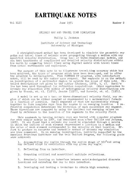
8 SEISMIC RAY AND TRAVEL TIME SIMULATION6. Adding the capability of specifying separate regions of velocitycharacteristics defined by either mathematical expressions or tables(matrix-associated values).7. Treating both curved and flat earth.8. Applying the concept to a three-dimensional model.A brief illustration of this segmental method is found in Fig. 1. whereseismic velocity and slope are associated with each matrix element. Referencingfor the slope is shown at element (2,1). An interface between two velocitylayers can be positioned between matrix elements as shown by the dottedline through B. The scale, or sampling interval, is the distance betweenmatrix elements as represented in kilometers. An incident ray segment oflength L and initial angle Ok extends from A to E. Coordinates of B are foundby extension from A: Esc = A x+ L sin 0 k'B z= A z+ L cos 0 k'The segmentBP 1is the first "probing" segment to obtain initial values of seismic velocityat midpoint 1. The angle 0, is computed with Snell's law, using emergingvelocity at midpoint 1, incident velocity at midpoint k, and incident angleOk. "Probing" segments are recomputed using successive values of 0, untiltne absolute value of (0, - Om_1) is less than a predetermined smalT value.The velocity and slope anociated with the segment BPm and the last computedvalue of Om are then used as the incident ray parameters, and a subsequentemerging angle is computed for the ray segment proceeding from point Pm.Many ray segments shown in Fig. 1 are joined togèther to form completerays. The remaining figures show systems of complete rays to illustrate theaccuracy and versatility of this method of seismic ray simulation. Figure 2shows travel time accuracy. Figures 3-12 are computer-drawn ray plots and atravel-time curve for which the values were produced by concurrent computationwith the ray plots.30i'11/7 ,/10,1n,7714211~,„„, MINE 1111111U1601801—Cl- 210240270Figure 3.--Computer output for 5 P-rays. 15 km sampling intervals of 1968 P-phase velocity distribution. 9 km segment lengths. Travel times from 1968P-phase tables shown for comparison.
<strong>EARTHQUAKE</strong> <strong>NOTES</strong>Figure 4.--Plots of P, PcP, PKP, PKIKP, PKKP, and PKIKKIKP rays generated witha spherical earth program. Jeffreys-Bullen core and 1968 P-phase mantle velocitydistributions. Radial velocity distribution sampled at 70 km intervals.70 km segment lengths.Figure 5.--Multiple reflections. PcP and PKP rays up to PKKKKKP. Four multiplereflections preset into computer program. Any number of multiple reflectionscan be preset into program.
10Figure 6. --Uniformity of plotting and travel times. Symmetrically plotted from 700 km depth. Ini~ia1angles from source are in increments of l~o from vertical. Ray plots and travel time shown for Ie ando342 0 rays. Maximum difference in travel time between symmetric rays is 0.11 seconds in PKP rays.rlLA.) A)N 09 090• CDCDCrlCa •• 00) 0H• 1—b0(D HH H.,ctH (DI-b 0H) H H)(D 01•5(D H HO 0 0O 0HjCD HO (D09• chI•3 0)00.)< 0CD H) chH IIH Q)ci- OD12.0MantleInitial Angle: 3420Initial Angle: 18°- A = 142.410TT = 18 min 13.79 secPKP<strong>EARTHQUAKE</strong> <strong>NOTES</strong>:33•+n-n•co P1-3t..5coG, 0C-11tv ncocn cpa)PKKP Initial Angle: 3420--¥------------,~-A = 107.85°TT = 28 min 24.14 secn—•• 0n—•7q,,4=.cn 0c-)§ Initial Angle: 180 PKKP _---------~ A = 252.22 0 _ .\-- - - - - _ --¥_~ l'T = 28 min 24.33 secg;Jex:InnerCorePInitial Angle: 342°A = 327.44° _TT = 8 min 3.75 secInitial Angle: 18°- A = 32.55°TT = 8 min 3.74 sec
SEISMIC RAY AND TRAVEL TIME SIMULATION 113L-xFigure 7.--Three-d1mensional ray tracing in a region defined by 30 x 30 x 30velocity samples. Constant velocity in planes parallel to the x, y, plane, increasingvelocity in z-direction for 15 sample points from the s, y, plane.Four cones of rays originating from point in the x, y plane. Rays emerging atthe x, y plane shown by slash marks with orientation of angle of emergence.Upper left: one-point perspective; remaining views; labelled orthographic projections.
12 <strong>EARTHQUAKE</strong> <strong>NOTES</strong>XFigure 8.--Line source at depth for three-dimensional representation as shownin Figure 8. Plotting defects in upper right (x,z) projection; all linesshould extend to x-axis.
SEISMIC RAY AND TRAVEL TIME SIMULATION 13Figure 9.--Three-dimensional ray tracing with velocity distribution definedby continuous mathematical function. Velocity = 4.0 + 0.15x + 0.3y + 0.6z,where volume is defined as in Figure 8.
14 <strong>EARTHQUAKE</strong> <strong>NOTES</strong>—B—ABINFigure 10.--Three-dimensional ray tracing with velocity functions specifiedfor different regions. Sampled values for intermediate layer between A and B.Velocity = 4.0 + 0.15x + 0.3y + 0.6z for layers above A and below B. Volumeis defined as in Figure 8.
100 km. Travel times for this plot are shown in Figure 12.z oH8~ HWFigure 11. --Ray paths from earthquake above idealized underthrusting lithosphere plateSEISMIC RAY AND TRAVEL TIME SIMULATION 15Depth of focus:
16 <strong>EARTHQUAKE</strong> <strong>NOTES</strong>4030Shadow Zone x,.43x.0.0X ./11)‘'.x,.x,/20Region of IdenticalTraveltimes10{Across UnderthrustingLithosphere0 From 1968 P-Phase Tables20 40 60 80 100 120 140 160 180 200 220 240 260 280DISTANCE FROM DISTURBANCE 4unlFigure 12.--Earthquake above underthrusting lithosphere at continental plateboundary. Depth of focus: 100 km. Travel times from 1968 P-Phase tables shownfor comparison. See Figure 11 for rap paths and velocity distribution.ReferencesBufe, C.G. (1969), "An Estimate of the Configuration of the Surface of theEarth's Core from the Consideration of Surface Focus PcP Travel Times,"Ph.D Dissertation, The University of Michigan, University Microfilms,Inc., Ann Arbor, Michigan.Jackson, P.L. (1970a). "Seismic Ray Simulation in a Spherical Earth," Bulletinof the <strong>Seismological</strong> Society of America, Vol. 60, No. 3, pp. 1021-1025.(1970b). "Digital Simulation of Seismic Rays," Fh.D Dissertation,The University of Michigan, University Microfilms, Inc., Ann Arbor,Michigan.(1970c). "Digital Simulation of Seismic Rays." Supplement toFinal Report Number 8071-33-F, Geophysics Laboratory, Willow Run Laboratories,Institute of Science and Technology, The University of Michigan,Ann Arbor, Michigan.Jacob, K.H. (1970). "Three-dimensional ray tracing in a laterally heterogeneousspherical earth." J. Geopbysical <strong>Research</strong>, 73, 6675Sorrels, G.G. J.B. Cramley, and K.F. Veith (1971?. "Methods for ComputingRay Paths in Complex Geological Structures. I Bulletin of the <strong>Seismological</strong>Society of America, Vol. 61, 27.Willis, D.E. and P.L. Jackson (1968). Collection and Analysis of Seismic WavePropagation Data, Report Number 8071-15-P, The University of Michigan,Willow Run Laboratories, Institute of Science and Technology, Ann Arbor,Michigan.Yacoub, N.K., J.H. Scott, and F.A. McKeown (1970). "Computer Ray Tracingthrough Complex Geological Models for Ground Motion Studies." Geophysics,35, 586.
17BROACH <strong>EARTHQUAKE</strong> OF MARCH 23, 1970S.K. Arora, G.J. Nair and T G 'VargheseSeismology Section, Nuclear Physics DivisionBhabha Atomic <strong>Research</strong> CentreTrombay, Bombay, IndiaABSTRACTThe Broach earthquake has been studied in detail. Fault plane solutionusing first motion P-data from 5 arrays and 51 ether stations indicates a possibletectonic royement along the NE striking Aravalli fault. Modified Cohenscepstral technique when applied to three teleseismic array records gives afocal depth of 21 km for the event, which coincides with the value obtained asa convergent solution to hypocenter by an iterative procedure using P arrivaltimes at 23 well distributed stations in the distance range 20° to 88°.IntroductionThe most recent earthquake of note which occurred in peninsular India wasthe one which rocked the town of Broach and adjoining areas in the western partof Gujarat State at about 01 hours 53 minutes GMT en March 23, 1970 The shockwhich was reported to have been feit within a radius of 300 km caused extensivedamage and destruction. The event for which the body-wave magnitude om Richterscale was estimated as 5.4 by USOGS (United States Coast and Geodetic Survey)and 6.0 by IMD (India Meteorological Department) represents a significant recurrenceof tectonic activity in the Cambay-Cutch region which experienced fivemajor earthquakes in recorded history (Gubin, 1968), viz. April 20 and 26, 1848and April 29, 1864 (Cambay region); June 16, 1819 and June 21, 1956 (Cutch regiem).A detailed analysis of the event was carried out using all the availableseismological data which included seismograms from the five Arrays, viz,Gauribidanur (GBA) in Southern India, Warramunga (WRA) in Australia, Eskdalemuir(EKA) in Scotland, Yellowknife (YKA) in Canada, Hagfors (HES) in Swedenand 51 other stations spread over India, Japan, France, Sweden, West Asia,Central Europe, Australia, Africa, America and the USSR. This has led tocertain interesting conclusions concerning its depth of focus and fault planeorientation which form the main theme of this note.The town of Broach is situated on the northern bank of River Narmada, ina regiem which marks the confluence of three distinct fault systems, viz. theNE-SW striking Aravalli folds extending as far as Delhi, the almost East-WestNarmada rift and the Western coastal fault with an approximately North-Southtrend. According to Geological opinion (Krishnan, 1953) none of these faultsextends to depths greater than 2000 meters.Some Parameters of the EventTable 1 lists the focal co-ordinates and origin time determined by threedifferent sources. The P-wave travel-time model used and the computationaltechniques adopted in each case are indicated. It is perhaps reasonable toassign a comparatively high degree of reliability to the third estimate, sinceit is based om a network chosen to provide goed azimuthal distribution of stationsto which the P paths are predominantly in the deep mantle se that azimuthaldependence of P-velocity and hence departures from standard travel timesare least significant.
18 <strong>EARTHQUAKE</strong> <strong>NOTES</strong>2SEC tUPMAG.183000AT1CPSWIDE -BAND _IAB3-.-—vtl‘FILTERED 0-4 CPSMAG. 25000 AT 1 C PSB2BROACH E ARTHQUAKE23 MARCH 1970O155:11.3 (GBA)Mb 5.4 (USCGS)Figure 1.--Typical records of the Broach earthquake of March 23, 1970, obtainedat two adjacent seismometer locations (B 3: 13°33'50.0" N, 77°24135.0"E;B 2: 13°35'15.0"N, 77°25'20.0"E) of Gauribidanur array. Pn onset time at thearray center point is 01:55:11.3.Two typical seismograms obtained at GBA which is approximately 950 kmsfrom the epicentre in the direction N 152° E are shown in Figure 1. The uppertrace is for a normal-gain channel having magnification of about 650,000 at thepredominant frequency of nearly 5 cps, while the lower trace corresponds tothe relatively low-gain channel which is about seven times less sensitive.These records clearly indicate, for the first P phase, a very feeble onset anda build-up time of about two seconds to reach the full amplitude. For at leasttwo seconds from its onset, the phase speed across the array is nearly constantat 7.9 km/sec. This value is characteristic of the Pn phase in the Deccan region(Arora, 1969). About seven seconds from the onset of the first P group,a second phase characteristized by a marked increase in period to 0.8 secondsand an apparent phase velocity of 8.1 km/sec is clearly recognizable. Theevidence for this slow build-up is not observable in seismograms at Hyderabad( A = 70; magnification 50,000 at 5 cps). Seismograms at YKA (p= 95.8°),EKA (A= 64.6°), WRA (A= 72.8°) and HFS (A= 56.2°) do not provide any indicationof a slow release of energy. It is possible, therefore, that the shockstarted with a small size, with very little P-energy at frequency well below 1cps which the teleseismic arrays and the relatively low-gain standard Benioffsystems at Hyderabad and Poona could not have sensed.
BROACH <strong>EARTHQUAKE</strong> OF MARCH 23, 1970 19Fault Plane SolutionFrom the direction of the first ground motion observed at 56 teleseismicstations, a fault plane solution was sought. Two orthogonal nodal planeswhich best fit the first motion data, are drawn in Figure 2 which representsthe equal area projection of the lower focal sphere on the equatorial plane.The only possible inference which these data permit is that the fault planecould be either the one striking N 120° E with a dip of about 720 in the NEdirection or the one striking N 51° E, and dipping about 44° towards SE direction.This may be taken to indicate that this earthquake was associated withmovements possibly along the NE striking Aravalli fault.Depth of FocusAn estimate of focal depth was obtained, independent of the use of traveltimes, with the help of velocity filtered seismograms of WRA, EKA and YKA eachof which gives fairly clear pP phase. The procedure followed is a modifiedversion of Cohen's (1970) method, and assumes similarity of pulse shape betweenthe P phase and the corresponding surface reflected phase which follows aftera time t given by2d cos et —a(1)where e is the angle of emergence of the P trajectory at the surface, d thefocal depth and a the mean overburden velocity. In order to reduce the effectof scattering and receiver site reverberations, about 2.5 seconds of the record,which contains the initial P phase, is autocorrelated against the entirerecord starting well before the onset and ending well beyond the coda of thepP phase. The computer programs developed by Robinson (1967) and Shanks (1967)were adapted for CDC 3600, for this purpose. The autocorrelation functions soobtained are then Fourier analyzed by the Fast Fourier Transform (Cooley andTukey, 1965) in two steps; first for only P part and then for the compositesection comprising both P and pP phases, attention being paid to ensure samefrequency resolution in both the cases. These two transforms Al(w) andtBi(w)1L B 2( w) Jmay be shown to be related by the matrix equation,i =r Bl(w)].... [Al(w)r 00sr-A2(w)1wt iLB2(w)J LA2(w) L Al(w)J i = 0i= jr sin wt.= o[ A (w) 2where the subscrips 1 an2 2 represent the real and imaginary parts and ti isthe time shift for the h pulse similar to the first P pulse. Vlues of ticorrespond to the peaks in the Fourier inversion of the solution of equation(2). Figure 3 shows the inverted transforms for the phased seismograms of thethree arrays. The most prominent peak which is attributable to the pP phasemay be seen to occur after the same time interval in the real and imaginarytransforms corresponding to each station. But this peak appears at progressivelylarger time intervals, at larger epicentral distances, more or less inconformity with equation (1), indicating thereby that this later arrival isnot a feature of the source. Minor peaks which represent reverberation ornoise at the receiving site are characterized by the inconsistency in theiroccurrence in the real and imaginary transforms corresponding to any one
20 <strong>EARTHQUAKE</strong> <strong>NOTES</strong>> 00• COMPRESSIONo DILArATION5BROACH <strong>EARTHQUAKE</strong> MARCH 23,1970Figure 2.--Equal area projection of the lower focal sphere representing faultplane solution of the Broach earthquake.
BROACH <strong>EARTHQUAKE</strong> OF MARCH 23, 1970 21108Dcr-i 420.67 2.0 3.38 4.7 6.08 7.44 8.4510FROM COSINE TRANSFORM(WRA, A72.8°)820.67 2.0 3.38 4.7 6.08 7.44 8.45FREQUENCY IN SecsFigure 3aFigure 3a, b, c.--The inverted transforms for the phased seismograms of Eskdalemuir,Warramunga and Yellowknife arrays.
22 <strong>EARTHQUAKE</strong> <strong>NOTES</strong>300-FROM COSINE TRANSFORM(YKA,A =95.83°2(1)1—z 200Dácr40100700.67 2.0 3.38 4.7 6.08 7.44 8.45FROM SINE TRANSFORM(YKA, A r. 95.83°)50300.67 2.0 3.38 4.7 6.08 744 8.45FREQUENCY IN Secs
BROACH <strong>EARTHQUAKE</strong> OF MARCH 23, 1970 23FROM COSINE TRANSFORM_ (EKA, A = 6462°)50 0 2 4 6 8 10 12 14FROM SINE TRANSFORM( EKA, A = 64.62°)10 0 2 4 6 8 10FREQUENCY IN SecsFigure 3e12 14
•▪•24<strong>EARTHQUAKE</strong> <strong>NOTES</strong>• c) Hp a)H•1 S-- •cd• ci)ctn ....— c) •,,o Zrn-, 1-1* ---cd •P E ........ c,-1t, a. on 0 H 0 ••0Q)'-- N N i-w A 4 04-DEaa)o cv o n.o • ro i-A"P tO 0 n0 0 .--,• ci) C co a) reiu cd Q cv") N rel • nD 44-) r.) H N- C-- C-- ..---. 0-)...p nC OH --,,0 n0 •----- •• I2c.) 4 ac, 0 InCr \ ..----, C•,-( -p 0 \D k.0 C-- H 4-) 0. g-. -P •--- H N- ,,-I HO4_, mO CC C3n ,H re,N NTABLE L. Three Cases of' Estimation of' the Source ParametersFocalDepth S.D.*(km) (sec)EpicenterNorth Eastw 19Hq8, g:ri0Ocy, 0 _1_,5 CC 5, rd ro as•H• . .0 a) O HEi— -- E aoC ..-I 1--- •• ..---,i • •(ll -P H 0) H c)•H C 1 Or) -P • CC CC cdhCr•-n Ill 4-) .--1 Fr, 1-- 0') c•H • • •H 0 • HH g-i > I-D es rnO 0 0 cd ., cdg-i O, -P ,CD 0' cd •H• H 5ca a) ---. ca H a Toa)Computational DetailsOri~in Time(GMT)Tra vel-timeMethod Model usedH E rci e c..d cd a) ‘"d•,-1 •,-1 a) --- ------. c, a.- , -I 0 cd 0cd 4-) 0 4-> (101UD •,-1 ..-1 U 54-) I 5 Ha) Ha)pi 0 .--11,--1 ,Z1) ""1-13 b g rd05a j rCICcot> cd g-1 00 0 Pel cd PH ca rcig-i 45 .,, • om g-1 o ir 7 a) 0-cdra cd ..----, ....--• P ' cdl q-4 O 0 0 •• cd CC00 cd 0.\ -- •Po 0 ., \-g Hm•,-1 .--,-P G-1 0 u] H Z cd H cdcd .._.- t.,_ (.5 ...-- •-__.---_-. 54-) 'd 4) I U H ., 'dO 0 ,PCnU) C cd • P. ca .,-1a. 4 ...... 1 c. cv 0 o 5 P. •H rnE 43 gr-1 1 •,--( H.,-1 a) g-1 a)o a) P o. • 0 H b°c, Z a r=1 o 4 o Ir\ ., cdcdZ 4-, P21 H N 0 Z a)o ca 0 5---- 7:5 5 ro E-1 00 ,--i-) ., .0 g .Hrn g n 0+ -I-)>, (1) i.--, 0 re G.) El ,C b.0 ,-Ib0 oocdto Cicd a)cd cd CO 00 a) 4-) 5---. to g=1 500 .- co IX 0. 0 cd cdrd C ,-, 0 7. ,L.1-1 , .1-1 ›, --1Stations UsedS.No. Reporting Total DistanceSource Number range (deg)a) cd 0 , 0 cd 'd G-4 F. H-Pco -1-, 0 4-) 1 4-3 4-) cd G-1 5 E-I cdUI b.0cd 0 4 C ca c) 'd a)M•H C cr) 0gr-1 cd r21 cd N0 5 I-D rci 0 0 a.) ,0CC @ •,, r.-i 0 -P«g Q) .-1 CES r2Ei 0•Hbp ra ,. 4-' 't--5cd 0 C.) c.) ',4 00 •H-P -- 5 .-i C ..0 G-1cd ,--I F.-1 0 d' a a) • ... 4-4-) cd 0 4 > 0 rIl Cicd o) -,-, ,0 4 I cr) 4--) g-i •H • .0 M cd •H •HO CQ 1 Cm g-i a) i:= P-, 4-)Eicd -P 0 bD en cdZill 5 cd t--4-) -I-) ..• 0 0 •n-I..—. 0, ,a) rp cb 0E > •E E --4-) Z • 0.,•H a) a)•H "d 5 Pci ca 4- rd g-id cd12 M c.) -P (I) 0 .0 cdI G) ..-, g-r14) -sm o p-, 'Cd)0 rn 0 Ti H Ca 1-1 4-, cda)C5 .. (1)0(1) OU'. '''.0 cd c)o d c.) 2 4-) ,o cd 5 0, g-, Q P. a) q:5 0a Q. 01-.1 ro cd 0 0 „1--I 5 ca g-1(0 a) ca
•-BROACH EARTHQUAK2 OF MARCH 23, 1970 25roV1-d- C--HOnHE o H 00 N N N,c ID gr,ri] rr4Table 2. Focal Depth Estimates Given by Power Spectral Ratio Measurementsusing Three Velocity Filtered Records.cl)0toas,a)O 5H Cl0O \C)O HFr, 11 LIlCr)E -7" Cij Ho• cY) Hi Hrr, H cv cv0•H4-) (ij 0 ("r) nco 4-) co cm Cl)(4 cc)5 + in k.e) .(:;H •H Hd • P-n 4-) H5-1 0 rij4-, q:5 EI r4o g-,0)0 1Q0 eup 0 ..---. ..pP, cts 0 0 0--, cl, * ko Cl) coa) ro ....— .H H3 (1) 4-) noEO]P, G.) W4-,H,0.H 5rr, cu.201 o> 4-) Cl.) 5 cd'0 004-' 0 4-DO 0 •r-1 00 k9 Cl") 0\0 O0 4-1 0 k9 CD CMta .--I 5 .-.5 PO 0 •H 4-, es d 0 CO --4-) > Cl) Hcd cn—n -P S-1 4-r5 a) 0000.,-1 a) cH-1-) a) ---. ...ca ,O H be (1.) -1-)[4 EH bij 0 0 o•%J ccs 0P bij •.:c .----q-i 954-)a •,-iO 0n oFocal depth (km )= 6.5 km sec- lFrom IIFrom IAzimuth Angle of incidenceStation at the (deg) at the sur- T (pp) - T(P)Code Epicenter face for a focal Estimate EstimateName (Deg) (deg . ) depth of about 20km 1* II+,0 a) ci) 0 (3 C—H rn -P 4-, ^ H cv inccs 4-, 4-3 •O 5 0 tij ai 0O 0 •H -P 0 (1.) N Nrr, 5 N cc5 H reS Cri.H....— CDFr-1EN0cHn0HcdPcd..---. al H Cr)E-1 bij CD (7\ c0 4.,cl)P.- (ij n 0U:,•n-1U]0c)50-,1 0-P (1) 0cd 7.1 E4-, 0 eiFr,gCf) 0 Z *20. 1419.45EKA 64.62 322.10 20.66 5.60 5.8021.3721.27WRA 72.91 120.29 18.65 6.20 6.2320.9621.13YKA 95.83 3.57 14.29 6.30 6.25* From cosine transforms.+ From sine transforms
26 EARTHOUAKE <strong>NOTES</strong>station as well as those of different stations.Table 2 gives the estimates of depth deduced from the time intervals forthe three array stations, derived from the transforms in Figure 3, and equation(1), using the tables computed by Eanghar (1970) from the Herrin(1968) travel times. The mean focal depth thus comes out to be 21 km.AcknowledgementsWe are exceedingly grateful to Dr. H.T.S. Thirlaway of the UKAEA for theexcellent array records. Thanks are due to the various seismological centres,which contributed data for this analysis, and also our colleagues who helpedus in one way or the other.ReferencesArora, S.K. and A.M. Manekar (1969). Precise Determination of Epicenters andOrigin Times of Surface Focus Seismic Events, Bull. Seism. Soc. Am., 59,777-788.Arora, S.K. (1969). Crustal Structure Near Gauribidanur Array, Proc. Symp.Tse of Gauribidanur Array Data for <strong>Seismological</strong> <strong>Research</strong>, July 4-5, 1969,4-30.Eanghar, A.R. (1.970). New Tables of Angles of Incidence of P Waves as a Functionof Epicentral Distance, Earthquake Notes, XLI, 45-58.Birtill, J.W. and E.E. Whiteway (1965). Application of Phased Arrays to theAnalysis of Seismic Body Waves, Phil. Trans. Roy. Soc. Lond., 258, 421-493.Bolt, B.A. (1960). The revision of earthquake epicenters, focal depths andorigin times using a high-speed computer, Geophys. J.R. Astro. Soc., 3,433 -440.Bolt, B.A. (1968). Estimation of PKP Travel Times, Bull. Seism. Soc. Am., 58,1305-1324.Cohen, T.J. (1970). Source-depth determinations Using Spectral, PseudoautoCorrelation and Cepstral Analysis, Geophys. J.R. Astro. Soc., 20, 223-231.Cooley, J.W. and J.W. Tukey (1965). An Algorithm for the Machine Calculationof Complex Fourier Series, Math. Comp., 19, 297-301.Gubin, I.E. (1968). Seismic Zoning of Indian Peninsula, Bull. Intern. Inst.Seism. Earthq. Engg., 5, 109-139.Herrin, E. (1968). Introduction to "1968 <strong>Seismological</strong> Tables for P Phases,"Bull. Seism. Soc. Am., 58, 1193-1241.Jeffreys, H. and K.E. Bullen (1958). <strong>Seismological</strong> Tables, Brit. Assoc. Adv.Sci., Gray Milne Trust, London.Krishnan, M.S. (1953). The Structural and Tectonic History of India, Mem. Geol.Surv. India, Vol. 81.Lander, J.F. (1970). <strong>Seismological</strong> Notes - March and April 1970, Bull. Seism.Soc. Am., 60, 1759-1764.Robinson, E.A. (1967). Multichannel Time Series Analysis with the Digital ComputerPrograms, San Francisco, Holden Day.Shanks, J.L. (1967). Recursion Filters for Digital Processing, Geophysics, 32,33-51.
27SPECIAL PROJECTS PARTYKenneth W. KingNOAANational Ocean SurveyThe <strong>Seismological</strong> Field Survey Party of San Francisco began recording thenuclear blasts with the 1946 Bikini tests continuing through the 1957 Nevadatests. The Special Projects Party was formally formed from the <strong>Seismological</strong>Field Survey Party in 1961, with the new headquarters at Mercury, Nevada,which is on the Nevada Test Site. In 1961 the party - 40 to 50 members whichincluded subcontractors, operated 5 trailer mounted mobile velocity meteringstations, 5 Wood-Anderson seismograph stations, and 15 accelerographs.Today the headquarters and laboratory is in Las Vegas with a complimentof 6 geophysicists and 15 electronic technicians who, due to the advances inthe equipment and increased operational efficiency, now operate 40 - 60 accele_rographs, 90 portable magnetic tape velocity systems, 5 twelve channel unbondedstrain gauge stations, one 12 channel bonded strain gauge station, 2twelve channel velocity meter engineering systems, and 4 blastmeters with assistsfrom 5 quartz rad strain stations.The Atomic Energy Commission Nevada Operations Office (AEC-NV00) is theprime contractor for the Party. They have an obligation to the military forthe weapon reserve; to the research laboratories, for development; and to thepublic for safety. They attempt to fulfill this obligation by use of contractonsand committees of consultants. Among these are: the Weather Bureau,Bureau of Public Health, Geological Survey, John A. Blume, Inc., etc. Manyleading engineers and seismologists are employed as consultants.Two branches of the Environmental Safety Division of the AEC,Dynamics(Seismic Engineering) and Seismology (aftershocks, etc.,) maintains the SpecialProjects Party under contract with NOAA. The Dynamics Branch has responsibilityfor; structural investigation, documentation, ground motion amplification/attenuation studies, research support, and research, while the <strong>Seismological</strong>Branch has responsibility for; local documentation of areas of real or suspectedseismic activity, and research support. This group is responsible forthe Aleutian studies carried out by NOS which shares with the Geological Surveythe task of monitoring aftershock activity at NTS. The Test Manager hasthe responsibility for; seismic plan coordination, perceptibility and publicreports, yield analysis, public information and displays, seismic consultationon program and plans and aftershock monitoring. Using the basic AEC contractas a vehicle to facilitate other contractual obligations, the Party doesspin off projects for the military, Plowshare, Corps of Engineers, NOS andUniversities. To fulfill these obligations we have participated in pro jectsin areas ranging from Columbia to Amchitka.The Party's standard operations fall into a naturel subgrouping of tasksbetween events and monitoring during events. When it is not getting ready fora nuclear or chemical event, the Party is occupied with: Nevada telemetrynetwork, Amchitka telemetry network, Nevada strong motion network, refractionprograms, vibration projects, equipment calibrations, record distribution,and special seismic studies.The Special Projects Party has a 17+ seismograph station telemetry networkwhich is tied to a western U.S. Network. The immediate system consistsof an integration of 7 Sandia stations, 4 USGS stations, and 10 NOS stations.
28 EARTHMAKE <strong>NOTES</strong>Cooperation is also carried out with NOAA's Earthquake Mechanism Laboratorystations at Eeatty and Warm Springs on the quartz strain program.The NOS seismic system in the Aleutians consists of eleven seismic stationson Amchitka Island, three seismic stations on islands near AmchitkaIsland and three cooperative seismic stations with Palmer Observatory. Theprogram is a total NOS arolytical/research effort which coordinates a tripartiteoperation into one cohesive seismic research program. The Las Vegasoffice operates the Aleutian Island portion, scales and formats all data forthe computer program and provides fiscal management of the program. PalmerObservatory operates seismograph stations on Shemya, Granite Mountain, andCape Sherchif in their standard network. The Rockville Office directs theanalysis and research. The resultant cooperation between the Party, theRockville Office and the observatories has worked smoothly.The Party maintains a strong-motion accelerograph network in Nevada whichincludes 22 high-rise buildings instrumented in Las Vegas, one in Beatty, onein Goldfield, and three in Tonopah. Cooperation is maintained with the <strong>Seismological</strong>Field Survey in operating instruments at Boulder Dam, Bishop, andHawthorne. The accelerographs are similar to those used throughout Californiaand at other strong motion stations except for the use of an automatic radiostarter.A truck has been modified to enable the Party to make shallow refractionstudies. The near geology, or velocity impedance matching, has been found tobe important to ground motion amplification studies. A commercial shallow refractionsystem has been modified to allow longer recording and deeper profiles.Two twelve-channel, wide spectrum velocity systems have been redesignedfor building vibration studies. The building or structure to be tested isinstrumented at the estimated 2nd mode nodal points with horizontal transducers.Energy input to the structure may be ambient background, cable pull,mechanical vibration, or human input. Approximately 170 high-rise structuresincluding some transmitter towers, and test structures have been shaken.Sixty-eight of these were buildings tested in Los Angeles subsequent to theFebruary 9, 1971 earthquake. Approximately 50 reports on vibration projectshave been written to date.Each nuclear event, high wind, or site test project produces a mass ofdata which may exceed one sheet-acre of paper and 100 kilometers of magnetictape. The tape data are read out on paper, scaled, logged, and dubbed onmaster tapes for archiving. The paper records are scaled, labeled, and reproducedafter which the master copy is archived. The master tape can thenbe band-pass filtered, compacted, or expanded to paper or tape reproductionsof the data of particular interest. Classified and unclassified archives ofthese records are maintained which now exceed 20,000 grams. Approximately1,000 grams per year are distributed on request.There is a continued problem of maintaining a known accuracy and precisionof the seismograph equipment. Accuracy can be calculated by normal methodsbut considerable effort is required to maintain the precision of a mobilesystem. Three to ten field trials are required each year, and continuouscross-checking of the records of events for consistency is necessary. Once ayear the accuracy of the field calibration is checked at the NOS Albuquerque<strong>Seismological</strong> Center. A calibration report is written on equipment every twoyears.The Special Projects Party is on call to the AEC Manager and Test Directorfor outside studies. We have been requested to produce Public Information
SPECIAL PROJECTS PARTY 29displays to be shown at Anchorage, Alaska, Geneva, Switzerland, and at allpublic nuclear events. In Geneva it is planned to have a table cam-driven toreproduce a one component seismogram similar to the Rulison event. Personnelfrom the Party evaluate outside agencies who request support for seismic projectsand also travel to the site of any local earthauake to work with theUniversities, such as Lamont-Doherty Geological Observatory, University ofUtah, and University of Nevada.The Party provides ambient seismicity measurements and data on groundand structural mations caused by nuclear and/or chemical detonations. The dataare subsequently used to document and validate pre-event predictions, to evaluatethe legitimacy of any damage complaints and to provide data to refinefuture predictions. Systems and operations designed for the unexpected mustbe used which can accomodate a very wide dynamic range of recorded motionsince the geology, and often the explosive device used does not conform toprecisely predictable response criteria. The systems must be pre and postfield calibrated and highly mobile. The overall seismic plan en a nuclear eventcovers documentation and research of the following: ground motion, structuralresponse, ambient seismicity pre and post events and miscellaneous as yield.MEASURING BUILDING SWAY CAUSED BY AN <strong>EARTHQUAKE</strong>There are both natural and artificial unbalanced farces which cause tallstructures to vibrate or sway in harmonie motion. Each building, like a tuningfork, has its own particular period or time in seconde to complete one cycle ofvibration. Movement may be caused by earthquakes, winds, and manmade forcessuch as traffic, heavy machines or even shaking machines which agitate theground or building and thus shake the structure. The oscillation periods maybe fairly constant for individual buildings, but peak acceleratinns vary betweenthe upper floors and the ground level. Only in recent years have a largenumber of buildings of different heights, configurations and types of constructien,and concentrated in the same limited area of earthquake potential,been equipped with comparable instruments for simultaneously recording theperiode of oscillations and the accelerations caused by applied forces.Since 1965 the city of Los Angeles, California, has required that allbuildings more than 6 stores in height with total floor area of 60,000 squarefeet or more, and all buildings more than 10 stores, be equipped with 3 strongmotionaccelerographs. Some structures have been so equipped during theirerection, thus permitting the recording of building vibrations imposed by differentforces at different stages of construction.Om April 8, 1968, the epicenter of the Borrego Mountain Earthquake of magnitude6.5 en the Richter scale, was 135 to 155 miles southeast of a cluster ofthese modern buildings in Los Angeles; each building had accelerographs en upperfloers and at the ground or basement levels. Recorded data were analyzedby scientists of the Environmental Science Services Administration (new theNational Oceanic and Atmospheric Administration (NOAA) of the United StatesDepartment of Commerce, and presented at a recent earthquake symposium.*In the case of the Borrego Mountain Earthquake, the ground-level motionswere borderline for activating the instruments. However, when magnified bybuilding height, these were sufficient to trigger upper floor instruments,which in turn set off the interconnected lower floor accelerographs. Recordedmotion en upper floors was observed to be near-sinusoidal, reflecting primarilythe fundamental periode of the buildings at levels of force well above thesenormally caused by light winds and traffic.*C1m1d,W.K., and R.P. Maley, "Building Period Measurements during an Earthquakewith Comments en Instruments," presented at the Third European Symposium enEarthquake Engineering, September 14 - 16, 1970, Sofia, Bulgaria.
30 <strong>EARTHQUAKE</strong> <strong>NOTES</strong>Calculations of the fundamental periode of the buildings were made usirgformulas approved by the Uniform Building Code, one of which involves the buildingheights and widths measured in feet. A simpler method is to take onetenthof the number of stores. For example, the period of a 42-story buildingwould calculate as 4.2 seconds by the latter formula. Figure 2 shows calculatedperiods using two different equations (dots and triangles) versus buildingperiode recorded during the earthquake. Had the calculated periode beenequivalent to the recorded periode all would have fallen on the slant line (1to 1 basis). While there is some scatter, it appears that periode calculatedby the simple formulas are reasonably conservative and can be used for buildingdesign calculations where the seismic factor must be taken into account.It was also found that values of a "dynamic coefficient" which depends onthe calculated fundamental periode would range from 85 to 150 percent of valuesresulting from use of periode recorded during the earthquake. This suggeststhat periode calculated by the simple estimate, rather than recorded periode,would be conservative, at least for buildings in the Los Angeles area. For example,for the tallest building in Los Angeles (42 stores) at the time of theearthquake, the least conservative value of the dynamic coefficient computedfrom the calculated period would be only 6 percent lower than the dynamic coefficientvalue from the recorded period. Conversely, the most conservativevalue determined for a 19 story building would be about 43 percent higher.Also, comparisons were made between records of fundamental periode of vibrationof these structures caused by light winds and by the Borrego MountainEarthquake. Upper floor maxipum accelerations ranged from 13 to 73 centimetersper second pr second (cm/sec') as compared to ground level accelerations of 4to 13 cm/sec' For light wind excitation, upper floor accelerations were inthe 1- cm/sec range.In the case of a rectangular, 9-story, steel-framed building in Pasadena,engineers (Hudson, Keightly, and Nielsen 1964) recorded vibration periodscaused by winds and manmade forces, as the structure developed from the frameworkstage to completion. A part of these tests included recordings of perioderesulting from the use of a shaking machine (Nielsen 1966). Accelerographs wereplaced on the roof and in the basement. During the earthquake, as recorded byCommerces Coast and Geodetic Survey scientists (now National Ocean Survey), thetime sequence of motion at roof level was roughly random, higher mode, andfinally, relatively pure fundamental mode. In the short direction of the buildingthe fundamental period was well defined at 1.5 seconde on the roof, with aslight indication of this period at the basement level. In the long directionof the building the period was lees well defined, with equal peaks occurring at1.00 and 1.15 seconds. The 1.00-second period also showed up strongly om thebasement spectrum, an anomaly which at present cannot be explained.Comparison of periode of this particular structure recorded during theearthquake with periode measured before and after indicates that:1. As floors, fireproofing, etc., were added, the short direction perioddecreased about 16 percent while the long direction period did not change.2. In the completed building, the long direction period was reduced byabout 5 percent but was unchanged for the short direction.3. The Borrego Mountain Earthquake lengthened the short direction periodby about 17 percent and the long direction period by about 10 percent.4. Motion caused by the earthquake did not exceed the elastic limits ofthe building since wind-excited periode measured before and after the earthquakewere the same.
MEASURING BUILDING SWAY CAUSED BY AN <strong>EARTHQUAKE</strong> 31Strong-motion accelerographs used in the various buildings in Los Angeleswere of 4 types, one developed in 1931 by the Coast and Geodetic Survey andthree developed and manufactured by private companies. Although different insize and construction, constants of all were such that recording was proportionalto acceleration for forcing periods longer than 0.1 second.Records of the periods of vibration of modern multistoried buildings andtheir accelerations caused by earthauakes, winds, and manmade excitations havebeen made and compared. In general, each building has its own unique, fundamentalperiod of sway which is near sinusoidal, but these periods are not fixedand can lengthen appreciably under earthquake excitation, in some cases by asmuch as 35 percent. For a single building the fundamental period varies asconstruction progresses from framework stage to final completion. Measurements,although made using 4 different type of accelerographs, are accurate and consistentfrom building to building, and from rooftop to basement. The C&GS,having initiated the strong-motion measurement program in 1930, continues as theNational Ocean Survey to serve as the central agency for operation of the network.LOS ANGELESAREAACCELEROORAPNSSAN ANDREAS FAULT ZONE•SAN JACINTO FAULT ZONEC.N0N<strong>EARTHQUAKE</strong>EPICENTERFigure 1.--The locatinn of the cluster of Los Angeles area accelerographsrelative to the epicenter of the Pnrrery M'untain earthquake,
32 <strong>EARTHQUAKE</strong> <strong>NOTES</strong>4.54.03.50 3.0D= Building derthH -.Building heightNI. Number of storiesO0c 2.5a.z2.0D 1.5U_sUI .00.50.5 1.0 1.5 2.0 2.5 3.0 3.5 40BUILDING PERIOD RECORDED DURING AN <strong>EARTHQUAKE</strong> -SECONDSFigure 2ReferencesHudson, D.E., W.O. Keightly and N.N. Nielsen, "A New Method for the Measurementof the Natural Periods in Buildings," Bulletin <strong>Seismological</strong> Societyof America, Vol. 54-1, February 1964, pp. 233-241.Nielsen, N.N., "Vibration Tests of a Nine-Story, Steel Frame Building," Journalof the Engineering Mechanics Division, American Society of Civil Engineers,Vol. 92, No. EMI, February 1966.
EASTERN SECTIONof theSEISMOLOGICAL SOCIETY OF AMERICAINFORMATION FOR CONTRIBUTORSThe Eastern Section of the <strong>Seismological</strong> Society of America welcomes andencourages technical manuscripts and special news items dealing with topicsrelated to the title of this publication. Authors submitting material forpublication should forward two typewritten copies plus single copies of theoriginal artwork (or glossy photographs) to:Rutlage J. BrazeeNOAA-National Ocean SurveySeismology DivisionRockville, Maryland 20852All material will be carefully reviewed by members of the Editorial Committeeand other knowledgeable individuals prior to publication. Therefore,material should be submitted three to four weeks prior to the quarterly publicationdate. The general format arrangement and final editing will be accomplishedby the Editor; however, the following guidelines are offered toassist the publication process:ABSTRACT: All technical papers should include an author-prepared abstractwhich summarizes the principal facts and conclusions of thepaper. Abstracts should normally not exceed one paragraph and willnot be required on special news items.LENGTH: Short technical papers are especially encouraged; however,proper consideration will be given to all material submitted.STYLE: Manuscripts should be prepared according to the instructionsand general style found in the Bulletin of the <strong>Seismological</strong> Societyof America.SPECIAL CHARGES: Figures with half-tones require special handlingand $4.00 per half-tone will be billed to the author. Other itemsrequiring special handling will also be billed (at cost) to theauthor. Charges for reprints are as follows: 100 copies of fourpagearticle - $29.00 ($2.45 for additional 100 copies); 100 copiesof eight-page article - $56.00 ($3.90 for additional 100 copies).ADVERTISEMENTS: Requests for advertising rates and for all other informationshould be forwarded to Rutlage J. Brazee, Editor, at theaddress above.
III • .~ • .. • ..CONTENTSSeismic Ray, and Travel Time SimulationPhilip L. Jackson ••••••••••Broach Earthquake of March 23. 1970S.K. AI'Ora. G.J. Nair and T.G. VargheseSpecial Projects PartyKenneth W. King • • •Measuring Building Sway Caused by an EarthquakePage5152326EDITORIAL COMMITTEEEditor:Rutlage J. Brazee, NOAA,Rockville, Md.Advisory Board:National Ocean Survey,E. R. Kanasewich, University of Alberta, Edmonton,Alberta, CanadaW. A. Rinehart, NOAA, National Ooean SurveyRockville, !'1d.O. W. Nuttli, Saint Louis University,St. Louis, Missouri