Leica DISTO™ D8 - GeoWILD
Leica DISTO™ D8 - GeoWILD
Leica DISTO™ D8 - GeoWILD
- No tags were found...

Create successful ePaper yourself
Turn your PDF publications into a flip-book with our unique Google optimized e-Paper software.
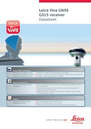
<strong>Leica</strong> DISTO <strong>D8</strong>The original laser distance meter
1234 568101279111314151621341238574766 5
<strong>Leica</strong> DISTO <strong>D8</strong>
User ManualEnglishCongratulations on the purchase of your <strong>Leica</strong> DISTO <strong>D8</strong>.ContentsCarefully read the Safety Instructions and the UserManual before using this product.The person responsible for the instrument mustensure that all users understand these directions andadhere to them.Safety Instructions...................................................................... 1Start-up ........................................................................................... 4Menu functions............................................................................ 6Operation ...................................................................................... 8Measuring....................................................................................... 9Functions........................................................................................ 9Working with BLUETOOTH®.......................................... 14Appendix ...................................................................................... 15Safety InstructionsSymbols usedThe symbols used in the Safety Instructions have the following meanings: WARNING:Indicates a potentially hazardous situation or an unintended usewhich, if not avoided, will result in death or serious injury. CAUTION:Indicates a potentially hazardous situation or an unintended usewhich, if not avoided, may result in minor injury and/or in appreciable material,financial and environmental damage.Important paragraphs which must be adhered to in practice as theyenable the product to be used in a technically correct and efficient manner.Use of the instrumentPermitted use• Measuring distances• Computing functions, e. g. areas and volumes• Storing measurements (BLUETOOTH®)• Measuring tiltsProhibited use• Using the instrument without instruction• Using outside the stated limits• Deactivation of safety systems and removal of explanatory and hazardlabels• Opening of the equipment by using tools (screwdrivers, etc.), as far asnot specifically permitted for certain cases• Carrying out modification or conversion of the productDGBFIEPNLCN<strong>Leica</strong> DISTO <strong>D8</strong> 766550a gb1Safety Instructions
DGBFIEPNLCN• Use of accessories from other manufacturers without the expressapproval of <strong>Leica</strong> Geosystems.• Deliberate or irresponsible behaviour on scaffolding, when usingladders, when measuring near machines which are running, or nearparts of machines or installations which are unprotected• Aiming directly into the sun• Deliberate dazzling of third parties; also in the dark• Inadequate safeguards at the surveying site (e.g. when measuring onroads, construction sites, etc.)Limits of useSee section “Technical Data“.The <strong>Leica</strong> DISTO is designed for use in areas permanently habitable byhumans, do not use the product in explosion hazardous areas or in aggressiveenvironments.Areas of responsibilityResponsibilities of the manufacturer of the original equipment <strong>Leica</strong> GeosystemsAG, CH-9435 Heerbrugg (for short <strong>Leica</strong> Geosystems):<strong>Leica</strong> Geosystems is responsible for supplying the product, including theUser Manual and original accessories, in a completely safe condition. (additionallanguage versions can be found at: www.disto.com.)Responsibilities of the manufacturer of non-<strong>Leica</strong>accessories:The manufacturers of non-<strong>Leica</strong> accessories for the <strong>Leica</strong> DISTOare responsible for developing, implementing and communicating safetyconcepts for their products. They are also responsible for the effectivinessof these safety concepts in combination with the <strong>Leica</strong> Geosystems equipment.Responsibilities of the person in charge of the instrument: WARNINGThe person responsible for the instrument must ensure that theequipment is used in accordance with the instructions. This person is alsoaccountable for the deployment of personnel and for their training and forthe safety of the equipment when in use.The person in charge of the instrument has the following duties:• To understand the safety instructions on the product and the instructionsin the User Manual.• To be familiar with local safety regulations relating to accident prevention.• To inform <strong>Leica</strong> Geosystems immediately if the equipment becomesunsafe.Hazards in use CAUTION:Watch out for erroneous distance measurements if the instrument isdefective or if it has been dropped or has been misused or modified.Precautions:Carry out periodic test measurements. Particularly after the instrumenthas been subject to abnormal use, and before, during and after importantmeasurements.Make sure the <strong>Leica</strong> DISTO optics are kept clean and that there is nomechanical damage to the bumpers. CAUTION:In using the instrument for distance measurements or for positioningmoving objects (e.g. cranes, building equipment, platforms, etc.) unforeseenevents may cause erroneous measurements.Precautions:Only use this product as a measuring sensor, not as a control device. Yoursystem must be configured and operated in such a way, that in case of anSafety Instructions2<strong>Leica</strong> DISTO <strong>D8</strong> 766550a gb
erroneous measurement, malfunction of the device or power failure dueto installed safety measures (e.g. safety limit switch), it is assured that nodamage will occur. WARNING:Flat batteries must not be disposed of with household waste. Care forthe environment and take them to the collection points provided in accordancewith national or local regulations.The product must not be disposed of with household waste.Dispose of the product appropriately in accordance with thenational regulations in force in your country.Always prevent access to the product by unauthorisedpersonnel.Product specific treatment and waste management information can bedownloaded from the <strong>Leica</strong> Geosystems home page athttp://www.leica-geosystems.com/treatment or received from your <strong>Leica</strong>Geosystems dealer.Electromagnetic Compatibility (EMC)The term "electromagnetic compatibility" is taken to mean the capability ofthe product to function smoothly in an environment where electromagneticradiation and electrostatic discharges are present, and withoutcausing electromagnetic interference to other equipment. WARNING:The <strong>Leica</strong> DISTO conforms to the most stringent requirements ofthe relevant standards and regulations. Yet, the possibility of it causing interferencein other devices cannot be totally excluded. CAUTION:Never attempt to repair the product yourself. In case of damage,contact the local dealership.Use of the product with BLUETOOTH®: WARNING:Electromagnetic radiation can cause disturbances in other equipment,in installations (e.g. medical ones such as pacemakers or hearing aids) and inaircraft. It can also affect humans and animals.Precautions:Athough this product conforms to the most stringent standards and regulations,<strong>Leica</strong> Geosystem cannot totally exclude the possibility of harm topeople and animals.• Do not use the product near petrol stations, chemical plants, in areaswith a potentially explosive atmosphere and where blasting takesplace.• Do not use the product near medical equipment.• Do not use the product in airplanes.• Do not use the product near your body for extended periods. CAUTION:Never attempt to repair the product yourself. In case of damage,contact the local dealership.Laser classificationIntegrated distancemeterThe <strong>Leica</strong> DISTO produces a visible laser beam which emerges from thefront of the instrument.It is a Class 2 laser product in accordance with:• IEC60825-1 : 2007 "Radiation safety of laser products"Laser Class 2 products:Do not stare into the laser beam or direct it towards other people unnecessarily.Eye protection is normally afforded by aversion responses includingthe blink reflex.DGBFIEPNLCN<strong>Leica</strong> DISTO <strong>D8</strong> 766550a gb3Safety Instructions
DGBFIEPNLCN WARNING:Looking directly into the beam with optical aids (e.g. binoculars, telescopes)can be hazardous.Precautions:Do not look directly into the beam with optical aids. CAUTION:Looking into the laser beam may be hazardous to the eyes.Precautions:Do not look into the laser beam. Make sure the laser is aimed above orbelow eye level. (particularly with fixed installations, in machines, etc.)LabellingLaser RadiationDo not stare into the beamLaser class 2acc. IEC 60825-1:2007Maximum radiant power:
KeypadSee figure {E}:1 ON / DIST (On/measuring) button2 Digital pointfinder - button3 Timer button4 Plus (+) button5 Minus (-) button6 Area / volume button7 Indirect measurement (Pythagoras) button8 Trapezium button9 Functions button10 Reference button11 Storage/Memory button12 Clear/Off button13 Menu/Equal button14 Bluetooth button15 Second function button16 Indirect measurement with tilt sensor buttonDisplay in normal modeSee drawing {F.1}.The graphics screen of the measurement window is split into differentareas. Top left is the brightest field, which contains the currently selectedmeasuring program. Just to the right appears the program submenu, whichshows the measuring programs that can be selected by pressing the samekey the required number of times.The measurement field contains the individual measurements of themeasuring program with reference to a series of separate distance measurements.Three lines are provided for this. A horizontal line separates themeasurement field and the result bar from one another. A red triangle indicateswhether the selected measuring program has a detailed display available.1 Program selection with measurement instructions2 Program selection submenu3 Level4 Timer5 Measurement field6 Result bar7 Detailed display8 Status bar with (Laser ON, Reference plane, Display Long range mode,Offset, Plus / Minus, Battery status, Bluetooth, 2nd)Display in "digital pointfinder" modeDigital pointfinder (3x zoom)The device has an integral digital pointfinder, which shows the targetdirectly on the display. The displayed crosshairs allow precise measurementsto be made even though the laser beam is not visible. See drawing{F.2}The integral coloured digital pointfinder is a great help outdoors and canbe used in every function. Longer distances and precise measurements ondetailed surfaces can even be accomplished in bright sunlight without anyproblem.The 3x zoom allows the image to be magnified to suit the user's requirements.Press the key to activate the function. Press the key again tooperate in a 1x, 2x or up to 3x zoom view.DGBFIEPNLCN<strong>Leica</strong> DISTO <strong>D8</strong> 766550a gb5Start-up
DGBFIEPNLCNThe brightness of the camera can be adjusted through 5 levels using thekey or thekey.Parallax errors occur when the digital pointfinder is used on closetargets, the laser dot may appear displaced in the crosshair. In this case youshould rely on the actual laser dot for targeting the object.See drawing {F.2}1 Zoom step (1x, 2x, 3x)2 Timer3 Level (in °)4 Crosshairs5 Inclination angle6 Distance tracking value7 ImageMenu functionsSettingsVarious device settings can be made in the menu. A vertical list shows eachentry. In this menu the selection field (cursor) remains stationary and thelist moves in a vertical direction. Starting from the centre of the list, thepriority of list entries starts at the top and fans out clockwise. See drawing{G}.The menu contains the following items:1 Units of measurement (distance)2 Units of measurement (angle)3 Display illumination4 Long range mode5 Tripod6 Beep7 Offset8 Digital pointfinder image in black/white9 Level in status field (in °)10 Reset11 Calibrate tilt sensorNavigation in the menuThe menu allows settings to be customised for a particular user or application.General descriptionPress and hold the key to enter the Setup menu.By pressing the or keys, navigate through the main menu itemsin the menu.Press the key briefly to enter the submenu of the selected mainmenu item.By pressing the or keys you can make the alterations in thesubmenu.Press and hold the key to accept the settings.Pressing the button for longer in the menu allows you to quit thesettings function without saving.Menu functions6<strong>Leica</strong> DISTO <strong>D8</strong> 766550a gb
Setting the unit for distance measurementsThe following units can be set:Distance Area Volume1.1 0.0000 m 0.000 m² 0.000 m³1.2 0.000 m 0.000 m² 0.000 m³1.3 0.00 m 0.000 m² 0.000 m³1.4 0.00 ft 0.00 ft² 0.00 ft³1.5 0'00'' 1 / 32 0.00 ft² 0.00 ft³1.6 0.0 in 0.00 ft² 0.00 ft³1.7 0 1 / 32 in 0.00 ft² 0.00 ft³1.8 0.000 yd 0.000 yd² 0.000 yd³Setting the unit for tilt measurementsThe following units can be set for tilt measurements:Units for tilt2.1 ± 90.0°2.2 ± 180.0°2.3 360.0°2.4 0.00 %2.5 0.0 mm/m2.6 0.00 in/ftDisplay illumination ( )The brightness of the display has six levels of adjustment. Step 6 is thebrightest and step 1 is the darkest setting.Long range Mode ( )Unfavourable conditions (strong sunlight or a very weak reflective targetsurface) may reduce the range of the device, in spite of this the long rangemode allows you to take measurements over longer distances. The use ofa tripod and measurement initiation by pressing the key are recommendedwhen measurements over 30m are made over longer time periodsin these conditions. (For details see Technical specifications)The settings are reset when the device is switched off.Measuring with the tripod ( )The reference point may be adjusted to the tripod mount if the userrequires a measurement from the actual mounting grommit versus thefront or back of the DISTO. To do this select the symbol in thismenu item. You can switch the reference on the tripod on or off. Thesetting can be seen on the display .We recommend that measurements are initiated using the keywhen using the device on a tripod in order to prevent loss of sharpness.The settings are reset when the device is switched off.Beep ( )You can switch the beep on or off.Offset ( )An offset adds or subtracts a specified value automatically to or from allmeasurements. This function allows tolerances to be taken into account(e.g. unfinished dimensions compared with finished dimensions). If youselected the Offset function in the menu, you can now adjust the valueusing the or the key. Pressing the key for longer increases therate of change of the values. When you reach the desired offset value,confirm it with the key. The display shows the appropriate symbolDGBFIEPNLCN<strong>Leica</strong> DISTO <strong>D8</strong> 766550a gb7Menu functions
DGBFIEPNLCNorfor as long as the offset value is set.Digital pointfinder image black / white ( )The display in pointfinder mode can be changed to black / white.Level in status field ( )The Level (in °) in status field can be switched on or off.Reset - returning the instrument to the factorysettings ( )The instrument has a Reset function. If you select the menu function Resetand confirm, the device returns to the factory settings and stack andmemory are deleted.All customised settings and stored values are also lost.Calibrate the tilt sensor ( )You can calibrate the tilt sensor in the device. Calibration requires twomeasurements on a level surface.Select calibration mode in the menu .1 Carry out a first measurement on a level surface. The deviceconfirms the measurement with .2 Rotate the device horizontally through 180° .3 Press the key and confirm that the device was rotated through180°.4 Press the key and take the second measurement. The deviceconfirms the measurement with .The tilt sensor is calibrated.OperationSwitching on and offSwitches on the instrument and laser. The display shows thebattery symbol until the next button is pressed.Pressing this button for longer switches the instrument off.The instrument switches off automatically after six minutes ofinactivity.CLEAR buttonThe last action is cancelled. While making area or volume measurements,each single measurement can be deleted andremeasured in series.Reference settingThe default reference setting is from the rear of the instrument.Press this button to take the next measurement from the front edge. A special beep sounds whenever the reference setting is changed.After a measurement the reference returns automatically to the defaultsetting (rear reference). See figure {H}.Press this button for longer the front reference is set permanently.Press this button, the rear reference is set again.Operation8<strong>Leica</strong> DISTO <strong>D8</strong> 766550a gb
MeasuringSingle distance measurementPress to activate the laser. Press again to trigger the distance measurement.The result is displayed immediately.Minimum/maximum measurementThis function allows the user to measure the minimum or maximumdistance from a fixed measuring point. It can also be used to determinespacings. See figure {I}It is commonly used to measure room diagonals (maximum values) or horizontaldistances (minimum values).Press and hold down this button until you hear a beep. Then slowlysweep the laser back and forth and up and down over the desired targetpoint - (e.g. into the corner of a room).Press to stop continuous measurement. The values for maximum andminimum distances are shown in the display as well as the last measuredvalue in the summary line.Laser continuous ( )Press and hold down the key when switching on the device until thecharacter appears permanently in the display and a beep sounds. Everyfurther press of the key releases a distance measurement.Press the key and keep it pressed to switch the device and Lasercontinuous operation off.If the laser is in continuous operation mode, the device switches offautomatically after 15 minutes.FunctionsOverview of the program iconsMeasuring program Icon Measurement1 - 2 - 3Simple distance measurementArea measurementVolume measurementTrapezoid measurement1 (using three distances)Trapezoid measurement2 (using two distancesand one angle)Pythagorean calculation1Pythagorean calculation2Pythagorean calculation3Inclination measurementDirect horizontaldistanceDoubletilt measurement 1Detail display1 - 2 - 3DGBFIEPNLCN<strong>Leica</strong> DISTO <strong>D8</strong> 766550a gb9Measuring
DGBFIEPNLCNMeasuring program Icon Measurement1 - 2 - 3(in the same quadrants)Doubletilt measurement 2Triangular area measurementStaking out functionProfile measurementAddition / subtractionDistance measuring.The next measurement is added to the previous one.The next measurement is subtracted from the previous one.This process can be repeated as required.Press this button and the result is then always shown in the summaryline with the previous value in the second line.The last step is cancelled.AreaPress once. The symbol appears in the display.Press this button to take the first length measurementlength).Press it again to take the second length measurementwidth).Detail display1 - 2 - 3(e.g.(e.g.Press this button and the result is shown in the summary line.Press and hold the key to display the perimeter .VolumePress this button twice. The symbol appears in the display.Press this button to take the first length measurement (e.g.length).Press this button to take the second length measurement (e.g.width).Press this button to take the third length measurement (e.g.height).Press this button and the volume value is shown in the summary line.Press and hold the button to display additional room informationsuch as ceiling/floor area , surface area of the walls , circumference.Trapezium measurement 1See drawing {J}Press the key once. The symbol is displayed.Press the key and take the first length measurement(e.g. height 1).Press the key again and take the second length measurement(e.g. width)Press the key and take the third length measurement(e.g. height 2).The result is shown in the summary row.Functions10<strong>Leica</strong> DISTO <strong>D8</strong> 766550a gb
Press and hold the key to display additional information about thetrapezium measurement, for example inclination angle , trapeziumarea .Trapezium measurement 2See drawing {K}.Press the key twice. This symbol is displayed.Press the key and take the first length measurement .Press the key and take the second length measurement and inclinationangle measurement.The result is shown in the summary row.Press and hold the key to display additional information about thetrapezium measurement, for example inclination angle , trapeziumarea .Triangular areaThe area of a triangle can be calculated by the measurement of three sides.See drawing {N}.Press the key once - the triangle symbol appears in the display.Press the key and measure the first side of the triangle .Press the key and measure the second side of the triangle .Press the key and measure the third side of the triangle .The result is shown in the summary row.Press and hold the key to display additional information about themeasurement, such as the angle included by the first two measurementsand the perimeter of the triangle.Stake out functionTwo different distances (a and b) can be entered into the instrument andcan then be used to mark off defined measured lengths, e.g. in the constructionof wooden frames.See figure {O}.Entering stake out distances:Press this button twice and the stake out function symbol appears inthe display .By using and , you can adjust the values (first a and then b) tosuit the desired stake out distances. Holding the buttons down increasesthe rate of change of the values.Once the desired value (a) has been reached it can be confirmed withthe button.Value (b) can be entered using and . The defined value (b)is confirmed with the button.Pressing the button starts the laser measurement. The display showsrequired stake out distance in the summary line between the stake outpoint (first a and then b) and the instrument (rear reference).If the DISTO is then moved slowly along the stake out line the displayeddistance decreases. The instrument starts to beep at a distance of 0.1mfrom the next stake out point.The arrows in the display indicate in which direction theDISTO needs to be moved in order to achieve the defined distance(either a or b). As soon as the staking out point is reached, the symbolappears in the display.The function can be stopped at any time by pressing the button.DGBFIEPNLCN<strong>Leica</strong> DISTO <strong>D8</strong> 766550a gb11Functions
DGBFIEPNLCNIndirect measurementThe instrument can calculate distances using Pythagoras’ theorem.This procedure is helpful, if the distance to measure can not be reacheddirectly.Make sure you adhere to the prescribed sequence of measurement:• All target points must be in a horizontal or vertical plane.• The best results are achieved when the instrument is rotated about afixed point (e.g. with the positioning bracket fully folded out and theinstrument placed on a wall) or the DISTO is mounted on a tripod.• The minimum/maximum function can be used - see explanation in"Measuring -> Minimum/maximum measurement". The minimum valuemust be used for measurements at right angles to the target; themaximum distance for all other measurements.Indirect measurement - determining a distance using 2auxilliary measurementsSee figure {P}e.g. for measuring building heights or widths. It is helpful to use a tripodwhen measuring heights that require the measurement of two or threemeasurements.Press this button once, the display shows . The laser is switchedon.Aim at the upper point (1) and trigger the measurement . Afterthe first measurement the value is adopted. Keep the instrument as horizontalas possible.Press and hold down this button to trigger continuous measurement, sweep the laser back and forth and up and down over the ideal targetpoint.Press to stop continuous measurement (2). The result is displayed inthe summary line, the partial results in the secondary line.Press and hold the key to display additional information about themeasurement of the angles of the triangle and .Indirect Measurement - determining a distance using 3measurementsSee figure {Q}Press this button twice; the display shows the following symbol .The laser is switched on.Aim at the upper point (1) and trigger the measurement. After thefirst measurement the value is adopted. Keep the instrument as horizontalas possiblePress and hold down this button to trigger continuous measurement, sweep the laser up and down over the ideal target point.Press to stop continuous measurement (2). The value is adopted. Aimat the lower point andpress this button to trigger the measurement (3) . The result isdisplayed in the summary line, the partial results in the secondary lines.Press and hold the key to display additional information about forexample the partial distances , and the minimum distance .Indirect measurement - determining a partial value using3 measurementsSee figure {R}e.g. determining the height between point 1 and point 2 using three targetpoints.Press this button three times ; the display shows the followingsymbol . The laser is switched on.Aim at the upper point (1).Functions12<strong>Leica</strong> DISTO <strong>D8</strong> 766550a gb
Press this button and trigger the measurementmeasurement the value is adopted.Triggers the measurementvalue is adopted.. After the first. After the second measurement thePress and hold down this button to trigger continuous measurement. Sweep the laser up and down over the ideal target point.Press this button to end continuous measurement. The result isdisplayed in the summary line, the partial results in the secondary lines.Press and keep pressed thekey to display additional informationabout the measurement of the partial lengths and .Indirect measurement with tilt sensorTilt measurementDuring tilt measurement the instrument should be held without atransverse tilt (max. 10°).If the device is tilted by more than ± 10° laterally, the displayshows infocode i 156 which means that the device has been tiltedtoo much.The units of inclination are set in the menu.Press this button once to activate the tilt sensor. The symbolappears in the display. The tilt is continuously shown as ° or % dependingon the setting.Press to measure the inclination and the distance. See figure {L}.Direct horizontal distancePress this button twice and the following symbol appears in the display.Press this button to measure tilt and distance. The summary linedisplays the result as the direct horizontal distance.Press and hold the key to display additional information about themeasurement, for example the inclination angle , the measured distanceand the indirect height .See drawing {M}.Double tilt measurement with one measured distanceThis procedure is particularly helpful if one target point of those to bemeasured cannot be reflective. The second target point can be simplypointed at with the digital viewfinder. In this measurement it is the angleonly and not the distance that is measured and therefore no special targetis required for the laser. See drawing {S}.Press the button three times. The following symbol appears inthe display.Press the button - tilt and distance are measured. If the tilt changes,the device updates the resulting height value and displays it in the summaryrow.Press the button - only the tilt is measured and the value of theresulting indirect height is frozen in the summary row .Press and hold the button to display additional information about themeasurement, such as the horizontal distance , the distance to thesecond measured point , or the height to the same point (pleasenote the different icons).Double tilt measurement with two measured distancesThis procedure is particularly suitable if the two measured points do notlie in the same vertical plane. The two target points are each measuredusing a distance and a tilt measurement. See drawing {T}.Press the button four times. The following symbol appears inthe display.DGBFIEPNLCN<strong>Leica</strong> DISTO <strong>D8</strong> 766550a gb13Functions
DGBFIEPNLCNPress the button - tilt and distance are measured.Press the button - tilt and distance are measured. The summaryrow shows the resulting distance between the two measured points .Press and hold the button to display additional information about themeasurement, such as the horizontal distance , the height differencebetween the measured points , or the included angle .Measure to the top target point first. This point must lie behind thebottom target point. If this is not the case, an error message appears in thedisplay.Profile measurementThis function is used to measure profiles and terrain sections. After measuringa reference point with a known height (e.g. bench mark or floor), theheight and horizontal distance to the instrument are displayed for eachfollowing point.We recommend using a tripod!Press the key five times.The following symbol appears on the display: .With and enter the known height of the reference point (e.g. -4,000 m in a construction system) and confirm with . The followingsymbol then appears on the display: .Now aim the instrument at the height reference point and press thekey - the gradient and distance are measured. The instrument is then readyto measure profile points .Measure the profile points by pressing the key. The horizontaldistance from the instrument to the measured point and the heightof the point are displayed.Press to exit the function.If the tripod and the instrument are moved, always restart the functionand measure the height reference point again before continuing tomeasure!Storage of constants / historical storageStorage of a constantYou can store and recall a frequently used value e.g. height of a room.Measure the desired distance, press and hold the button until thedevice beeps to confirm storage.Recalling the constantPress this button once to recall the constant and then press thebutton to enter it into your calculation.Historical storagePress this button twice and the previous 30 results (measurementsor calculated results) are shown in reverse order.The and buttons can be used for navigation.Press this button to use a result from the summary line for furthercalculations.Pressing the and buttons at the same time erases all the valuesin historical storage.Timer (self-triggering)Press this button to set a 5-second time delayorPress and hold down this button until the desired time delay isreached (max. 60 seconds).Functions14<strong>Leica</strong> DISTO <strong>D8</strong> 766550a gb
Once the key is released with the laser activated, the remaining secondsuntil measurement (e.g. 59, 58, 57...) are displayed in a countdown. The last5 seconds are counted down with a beep. After the last beep the measurementis taken and the value is displayed.The timer can be used for all measurements.Working with BLUETOOTH®Switching on BLUETOOTH® / sending measurementsA quick press on the - key starts DISTO BLUETOOTH®. The dataconnection must then be established out from a Pocket PC / PC by theapplication software. A grey - icon will appear in the display until thishas been successfully completed. BLUETOOTH® automatically switchesoff if the connection to the Pocket PC / PC is not established within 240sec from when the BLUETOOTH® was switched on.Whilst the first connection between the Pocket PC/PC and theDISTO is being established, a prompt for the Pin-code of the DISTOmay be displayed. In this case, enter the code 0000 into your Pocket PC/PC.Switching off BLUETOOTH®BLUETOOTH® switches off as soon as the DISTO is switched off.The direction keysEight direction keys (identified by a small arrow near the key) on theoperator's keypad are used to manoeuvre the cursor. The direction keysbecome active when you switch to the second level (by pressing thekey). The distance measuring key is active in both levels. The functionalityof the direction keys depends on the software used.Transmitting the measurementIf your software supports the direction keys use them to select the appropriateposition for the cursor.Press the button briefly to transfer the value from the summary rowto the pocket PC / PC.For further details please consult your manual for the software used.Selecting particular values in the displayThe display shows a number of measurements (min., max., last measurementtaken). By pressing and holding the button you can select allmeasurements in the display for transmitting (blue lines under the measurements).When you press the - key or the - key you can selectone specific value. Once selected the measurement can be transmittedusing the - key. The same selection process can be used for areas,volumes, indirect measurements and room dimensions.During data transmissionIf the data is not confirmed as being successfully received by the Pocket PC/PC then no new measurement can be processed. The Info code "240"appears in the display if no data transmission has taken place after 2seconds. Press the - key and repeat the measurement and thentransmit it.The free software supplied is designed to provide the user withbasic functionality. <strong>Leica</strong> Geosystems provides no warranty for this freesoftware and offers no support for it. <strong>Leica</strong> Geosystems accepts no liabilityDGBFIEPNLCN<strong>Leica</strong> DISTO <strong>D8</strong> 766550a gb15Working with BLUETOOTH®
DGBFIEPNLCNwhatsoever arising from the use of the free software and is not obliged toprovide corrections nor to develop updates or upgrades.You can find numerous commercial vendors of software for a wide rangeof applications on our homepage.AppendixMessage codesAll message codes are displayed with eithererrors can be corrected:or "Error". The followingCauseRemedy156 Transverse tilt greater than 10° Hold the instrument withoutany transverse tilt162 The calibration has not beenaccomplished on a levelledCalibrate the device on an absolutehorizontal levelled surface.surface and the calibration valueis respecitvely within an ineligiblearea.204 Calculation error Repeat procedure240 Data transfer error Repeat procedure245 2nd button pressed although no Establish Bluetooth connectionBluetooth connection exists.252 Temperature too high Cool down instrument253 Temperature too low Warm up instrument255 Receiver signal too weak, Use target platemeasurement time too long,distance > 100 m256 Received signal too strong Target too reflective (use targetplate)257 Wrong measurement, backgroundbrightness too highDarken target (measure in differentlighting conditions)260 Laser beam interrupted Repeat measurementError Cause RemedyError Hardware error Switch on/off the device severaltimes. If the symbol still appears,then your instrument is defective.Please call your dealer forassistance.Technical dataDistance measurements:Measuring accuracy up to 10 m (2 σ)Power Range Technology:Range (use target plate from about 100 m)Smallest unit displayedDistance measurementMinimum/maximum measurement, ContinuousmeasurementArea/volume calculation of room dataAddition / subtractionIndirect measurement using PythagorasTrapezium measurementTilt measurements:Tilt sensor:Accuracy (2 σ)- to laser beam- to the housingIndirect measurement using tilt sensor(direct horizontal distance)Angle measurement using tilt sensor(360°)General:Laser classLaser typeØ laser point(at distances)Autom. laser switch-offtypically: ± 1.0 mm*0.05 m to 200 m0.1 mm- 0.1° / +0.2° **± 0.1° **II635 nm, < 1 mW6 / 30 / 60 mm(10 / 50 / 100 m)after 3 minAppendix16<strong>Leica</strong> DISTO <strong>D8</strong> 766550a gb
Autom. instrument switch-offDisplay illuminationMultifunctional endpieceTimer (self-triggering)Save constant valueHistorical storageBLUETOOTH® 2.0Range of BLUETOOTH® Cl. 2Tripod thread (Type: 1/4-20)Battery life,Type AA, 2 x 1.5VProtection against splashes and dustDimensionsWeight (with batteries)Temperature range:StorageOperation* maximum deviation occurs under unfavourable conditions such as bright sunlight orwhen measuring to poorly reflecting or very rough surfaces. Measuring accuracybetween 10 m and 30 m may deteriorate to approx. ± 0.025 mm/m, for distancesabove 30 m to ± 0.1 mm/m. In long range mode the maximum deviation from adistance of 30 m increases to +/- 0.15 mm/m.** applies at room temperature. For the whole operating temperature range themaximum deviation increases by +/- 0.1°.Measuring conditionsafter 6 min30 values10 mup to5 000 measurementsIP 54, dust-proof,splash-proof143.5 x 55 x 30 mm195 g-25°C up to +70°C(-13°F up to +158°F)-10°C up to +50°C(14°F up to +122°F)Measuring rangeThe range is limited to 200 m.At night or dusk and if the target is in shadow the measuring range withouttarget plate is increased. Use a target plate to increase the measurementrange during daylight or if the target has poor reflection properties.Target surfacesMeasuring errors can occur when measuring toward colourless liquids (e.g.water) or dust free glass, Styrofoam or similar semi-permeable surfaces.Aiming at high gloss surfaces may deflect the laser beam and lead to measurementerrors.Against non-reflective and dark surfaces the measuring time may increase.CareDo not immerse the instrument in water. Wipe off dirt with a damp, softcloth. Do not use aggressive cleaning agents or solutions. Handle theinstrument as you would a telescope or camera.WarrantyThe <strong>Leica</strong> DISTO <strong>D8</strong> comes with a three* year warranty from <strong>Leica</strong>Geosystems AG.More detailed information can be found at: www.disto.comAll illustrations, descriptions and technical specifications may be subject tochange without prior notice.* To receive the three year warranty, the product must be registered on our websitewww.disto.com within eight weeks of the purchase date. If the product is notregistered, a two year warranty applies.DGBFIEPNLCN<strong>Leica</strong> DISTO <strong>D8</strong> 766550a gb17Appendix
<strong>Leica</strong> DISTO <strong>D8</strong>
EXIT213max.
<strong>Leica</strong> Geosystems AG, Heerbrugg, Switzerland has been certified as being equipped with a quality systemwhich meets the International Standards of Quality Management and Quality Systems (ISO standard 9001)and Environmental Management Systems (ISO standard 14001).Total Quality Management - Our commitment to total customer satisfaction.Ask your local <strong>Leica</strong> Geosystems agent for more information about our TQM program.Printed in Switzerland - Copyright <strong>Leica</strong> Geosystems AG, Heerbrugg,Switzerland 2009Translation of original text (766550a)Pat. No.: WO 9427164, WO 9818019, WO 0244754, WO 0216964,US 5949531, EP 1195617, US 7030969, WO 03104748<strong>Leica</strong> Geosystems AGCH-9435 Heerbrugg(Switzerland)www.disto.com