asscciation for mexican cave studies box 7672 ut station austin ...
asscciation for mexican cave studies box 7672 ut station austin ... asscciation for mexican cave studies box 7672 ut station austin ...
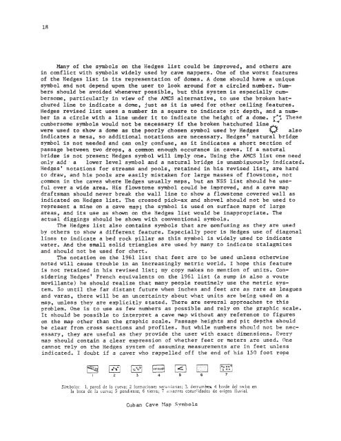
18Many of the symbols on the Hedges list could be improved, and others arein conflict with symbols widely used by cave mappers. One of the worst featuresof the Hedges list is its representation of domes. A dome should have a uniquesymbol and not depend upon the user to look around for a circled number. Nu~bers should be avoided whenever possible, but this system is especially cumbersome,particularly in view of the AMCS alternative, to use the broken hatchuredline to indicate a dome, just as it is used for other ceiling features.Hedges revised list uses a number in a square to indicate pit depth, and a numberin a circle with a line under it to indicate the height of a dome. r- 1 Thesecumbersome symbols would not be necessary if the broken hatchured line~~were used to show a dome as the poorly chosen symbol used by Hedges ~ alsoindicates a mesa, so additional notations are necessary. Hedges' natural bridgesymbol is not needed and can only confuse, as it indicates a short section ofpassage between two drops, a common enough occurance in caves. If a naturalbrid2e is not present Hedges symbol will imply one. Using the AMCS list one needonly add· a lower level symbol and a natural bridge is unambiguously indicated.Hedges' notations for streams and pools, retained in his revised list, are hardto draw, and his pools are easily mistaken for large masses of flows tone , notcommon in the caves where Hedges usually maps, but an NSS list should be usefulover a wide area. His flows tone symbol could be improved, and a cave mapdraftsman should never break the wall line to show a flows tone covered wall asindicated on Hedges list. The crossed pick-ax and shovel should not be used torepresent a mine on a cave map; the symbol is used on surface maps of largeareas, and its use as shown on the Hedges list would be inappropriate. Theactual diggings should be shown with conventional symbols.The Hedges list also contains symbols that are confusing as they are usedby others to show a different feature. Especially poor is Hedges use of diagonallines to indicate a bed rock pillar as this symbol is widely used to indicatewater. And the small solid triangles are used by many to indicate stalagmitesand should not be used for chert.The notation on the 1961 list that feet are to be used unless otherwisenoted will cause trouble in an increasingly metric world. I hope this featureis not retained in his revised list; my copy makes no mention of units. ConsideringHedges' French equivalents on the 1961 list (a sump is also a voutemovillante) he should realize that many people routinely use the metric system.So until the far distant future when inches and feet are as rare as leaguesand varas, there will be an uncertainty about what units are being used on amap, unless they are explicitly stated. There are several approaches to thisproblem. One is to use as few numbers as possible and rely on the graphic scale.It should be possible to interpret a cave map without any reference to figureson the map other than the graphic scale. Passage heights and pit depths shouldbe clear from cross sections and profiles. But while numbers should not be necessary,they are useful as they provide the user with exact dimensions. Everymap should contain a clear expression of whether feet or meters are used. Onecannot rely on the Hedges system of assuming measurements are in feet unlessindicated. I doubt if a caver who rappelled off the end of his 150 foot rope841 c::: I0·..····: :-;:',':-5 6Simbolos: 1, pared de In cueva; 2 formociones secul1,}orias; 3. derrumbe!l; 4 corde del techo en1a boca de Ia luevo; 5 pendieme; 6 tierra; 7 a:Hstres cOn:i()lidados de origen fluvial.Cuban Cave Hap Svmbols
19in a 90 meter pit could collect damages either from the map maker or Mr. Hedges,but with foresight these problems can be minimized.The revised Hedges list is an improvement over the 1961 list presented hereas he now uses the broken hatchures for ceiling features, but he needs to expandits use and use it for all ceiling features including domes. Cross sections arethe best way to show heights of domes and depths of pits when the shaft extendsboth above and below the passage. His revised list also includes a symbol lackingon the 1961 list, a symbol for a bed rock floor. He proposes a rectilinearcrosshatch be used, but even he admits it is a poor symbol, and suggests that itbe used only when absolute~y necessary, that normally if floor sediments are mappeda blank space will represent a bed rock floor. This is a poor practice as cavemappers frequently do not have data for some of the cave, a good bed rock floorsymbol would be much better. Hedges new list still has a cumbersome system forindicating pits and domes, as well as other symbols that are confusing or inappropriate.It should not be adopted as a standard list by the NSS as it would notmeet with general acceptance, and would be a setback to the slow progress beingmade towards the adoption of a uniform system of map symbols. The set of symbolsused by the AMCS should be adopted as it is a versatile and practical system inwide use and acceptable to a greater number of cavers.E X P l I C A C I O'N.J LEntradaPendientefurrtrff.. •.lZSe c cionmAUuro del hc"oTBlocho bolojlEntrada~.DecliveillAltura delT.B.TechobojotechoEXP:"ICACION} r-E·"roclct9". Declive;..-~P~IIC:I'''f'~".rt.EXPLICACION;; rEnl, ado'0DecliveAllura del 'echoLimi'!'e deJutGravaCohJClQEstociontopoQn:ifico~ColadoColumnabeUolo;mitico---Arcillo 0 bortOCorte a piceAQuafstoncoda~Agua esta~ada~Pendiente fuertex~Cruce baj 0 nivelTA-mA~~l,lro .::1\'1 r.eho80rro 0 QrC:llloCorte Qplco~Cruce bajo nivelAQueAQuaestoncodacorrienff''EstaeiontopogroficaROCClIPOZO.....'Ob'furOdOMexican Cave ~~pSymbols
- Page 1: ASSCCIATION FOR MEXICAN CAVE STUDIE
- Page 5 and 6: 3So the large-entranced sotano whic
- Page 7 and 8: 5MINA OTATES, T&~.: DSC. 25, 1974,
- Page 9: MERIDA, YUC.: OCT. 1974, David McKe
- Page 13 and 14: AMCSMEMBERSHIP ACTIVITIES LETTEREdi
- Page 15 and 16: 3Michael Schulte has been working o
- Page 17 and 18: 5To the right of the partition in t
- Page 19 and 20: 7Diamond Cave RevisitedAndy Grubbs,
- Page 21 and 22: 9CHE~-VEN-SIL-MUTSYSTEM\+--1000 ft.
- Page 23 and 24: Cave Map Symbols11On the following
- Page 25 and 26: 13I NATIONAL SPELEOLOGICAL ISOCIETY
- Page 27 and 28: ASSOCIATION FOR MEXIC&~ CAVE STUDIE
- Page 29: 17Discussion of Map Symbolsby Bill
- Page 35 and 36: AMCSACTIVITIES LETTEREdited by Bill
- Page 37 and 38: 3After leaving Valladolid we went t
- Page 39 and 40: CASI UlL 5By Bill Stone as told to
- Page 41 and 42: June 97Dear AMCSRE:Diamond CaveAfte
- Page 43 and 44: Anyways we speleo-boppedEstrella an
- Page 45 and 46: The adrenelin still pumping through
- Page 47 and 48: 13Sotano Hondo de Pina1itoBy Steven
- Page 49 and 50: CAVE MAP SYMBOLS(continued)15The AM
- Page 51 and 52: mechanical shading -- the dots, con
- Page 53 and 54: morphogenetic feature involving gra
- Page 55 and 56: height variation, say. across the w
- Page 57 and 58: 23that list to include a broader se
- Page 59 and 60: 25be represented by rigidly p,eomet
- Page 61 and 62: 27..• D. 0. ȯGravelFEATURENOTESS
- Page 63: ASSOCIATION FOR MEXICAN CAVEUAP Snm
- Page 67 and 68: AlfCSACTIVITIES LETTEREdited by Bil
- Page 69 and 70: 35. I personally had the following
- Page 71 and 72: volunteered to rescue the bag. They
- Page 73 and 74: one large black hole near the top o
- Page 75 and 76: The next day we left camp at dawn a
- Page 77 and 78: 11First Exploration of NogalThursda
- Page 79 and 80: '"entire passage has·solutional ro
18Many of the symbols on the Hedges list could be improved, and others arein conflict with symbols widely used by <strong>cave</strong> mappers. One of the worst featuresof the Hedges list is its representation of domes. A dome should have a uniquesymbol and not depend upon the user to look around <strong>for</strong> a circled number. Nu~bers should be avoided whenever possible, b<strong>ut</strong> this system is especially cumbersome,particularly in view of the AMCS alternative, to use the broken hatchuredline to indicate a dome, just as it is used <strong>for</strong> other ceiling features.Hedges revised list uses a number in a square to indicate pit depth, and a numberin a circle with a line under it to indicate the height of a dome. r- 1 Thesecumbersome symbols would not be necessary if the broken hatchured line~~were used to show a dome as the poorly chosen symbol used by Hedges ~ alsoindicates a mesa, so additional notations are necessary. Hedges' natural bridgesymbol is not needed and can only confuse, as it indicates a short section ofpassage between two drops, a common enough occurance in <strong>cave</strong>s. If a naturalbrid2e is not present Hedges symbol will imply one. Using the AMCS list one needonly add· a lower level symbol and a natural bridge is unambiguously indicated.Hedges' notations <strong>for</strong> streams and pools, retained in his revised list, are hardto draw, and his pools are easily mistaken <strong>for</strong> large masses of flows tone , notcommon in the <strong>cave</strong>s where Hedges usually maps, b<strong>ut</strong> an NSS list should be usefulover a wide area. His flows tone symbol could be improved, and a <strong>cave</strong> mapdraftsman should never break the wall line to show a flows tone covered wall asindicated on Hedges list. The crossed pick-ax and shovel should not be used torepresent a mine on a <strong>cave</strong> map; the symbol is used on surface maps of largeareas, and its use as shown on the Hedges list would be inappropriate. Theactual diggings should be shown with conventional symbols.The Hedges list also contains symbols that are confusing as they are usedby others to show a different feature. Especially poor is Hedges use of diagonallines to indicate a bed rock pillar as this symbol is widely used to indicatewater. And the small solid triangles are used by many to indicate stalagmitesand should not be used <strong>for</strong> chert.The notation on the 1961 list that feet are to be used unless otherwisenoted will cause trouble in an increasingly metric world. I hope this featureis not retained in his revised list; my copy makes no mention of units. ConsideringHedges' French equivalents on the 1961 list (a sump is also a vo<strong>ut</strong>emovillante) he should realize that many people ro<strong>ut</strong>inely use the metric system.So until the far distant f<strong>ut</strong>ure when inches and feet are as rare as leaguesand varas, there will be an uncertainty abo<strong>ut</strong> what units are being used on amap, unless they are explicitly stated. There are several approaches to thisproblem. One is to use as few numbers as possible and rely on the graphic scale.It should be possible to interpret a <strong>cave</strong> map witho<strong>ut</strong> any reference to figureson the map other than the graphic scale. Passage heights and pit depths shouldbe clear from cross sections and profiles. B<strong>ut</strong> while numbers should not be necessary,they are useful as they provide the user with exact dimensions. Everymap should contain a clear expression of whether feet or meters are used. Onecannot rely on the Hedges system of assuming measurements are in feet unlessindicated. I doubt if a <strong>cave</strong>r who rappelled off the end of his 150 foot rope841 c::: I0·..····: :-;:',':-5 6Simbolos: 1, pared de In cueva; 2 <strong>for</strong>mociones secul1,}orias; 3. derrumbe!l; 4 corde del techo en1a boca de Ia luevo; 5 pendieme; 6 tierra; 7 a:Hstres cOn:i()lidados de origen fluvial.Cuban Cave Hap Svmbols


