Datganiad Cadwraeth Clawdd Offa Offa's Dyke Conservation ...
Datganiad Cadwraeth Clawdd Offa Offa's Dyke Conservation ...
Datganiad Cadwraeth Clawdd Offa Offa's Dyke Conservation ...

You also want an ePaper? Increase the reach of your titles
YUMPU automatically turns print PDFs into web optimized ePapers that Google loves.
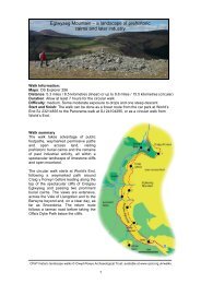
15 <strong>Datganiad</strong> <strong>Cadwraeth</strong> <strong>Clawdd</strong> <strong>Offa</strong><strong>Offa</strong>'s <strong>Dyke</strong> <strong>Conservation</strong> Statement 15Mellington i ButtingtonPowys a Swydd Amwythig2.13 Mae 18.4 km o’r llwybr wedi goroesi. I’r gogledd oMellington, mae’r clawdd yn ffarwelio â’r tir uchel ac yn myndyn ei flaen ar hyd y gwastadedd i’r dwyrain o Drefaldwyn mewnllinell syth a phendant. Mae cyflwr y clawdd yn newid yn sydyno gae i gae, yn amrywio o’r clawdd a’r ffos enfawr y gellir eugweld wrth Bont Ffin y Sir ychydig i’r de o ffordd Trefaldwyn iAmwythig, i adrannau lle nad oes modd gweld ond mymryn o’rclawdd sydd wedi ei erydu neu ffos sydd wedi ei llenwi, neu llenad oes dim ond llinell y gwrych ar ôl. O Ffordyn, mae’r clawdd,yn ddiddorol iawn, yn dargyfeirio i fyny ar hyd ystlys LongMountain, cyn cwympo’n ôl i wastadedd Afon Hafren ynButtington.2.14 Cyd-destun y Dirwedd Bu ffermio âr dwys yn NyffryndirTrefaldwyn am flynyddoedd lawer, ac mae gweithgareddau o’rfath yn parhau hyd heddiw, er bod llawer o borfa i’w gweld hefyd.Mae Cadw wedi cofrestru’r ardal yn Dirwedd o DdiddordebHanesyddol Eithriadol, ac mae rhannau o’r clawdd hefyd yn myndtrwy ardal Lymore a Thre’r Llai sydd wedi’i chofrestru yn Barc aGardd o Ddiddordeb Hanesyddol Eithriadol. Mae’r gwrthglawdd,sy’n ffurfio rhan o’r ffin rhwng Cymru a Lloegr, i’w weld yn amlwgfel rheol fel nodwedd unionlin sy’n rhannu iseldir y dirweddrhwng aneddiadau gwledig yr Ystog, Trefaldwyn,Llanffynhonwen a’r Trallwng; mae’r prysgwydd a’r coetir syddwedi tyfu ar hyd yr henebyn yn llunio ei gymeriad gweledol. ArLong Mountain mae rhannau helaeth o’r clawdd yn rhedeg trwyblanhigfeydd conwydd, ac o’r herwydd mae’n anodd gweld ygwrthglawdd yn amlwg yn yr ardal i’r gorllewin. Mae Llwybr<strong>Clawdd</strong> <strong>Offa</strong> yn dilyn hynt y clawdd yn agos yn yr adran hon.Mellington to ButtingtonPowys and Shropshire2.13 18.4 km extant. North of Mellington, the dyke abandonsthe high ground and strikes out across the lowland plain eastof Montgomery with a straight and deliberate course. Thestate of preservation of the dyke changes abruptly from fieldto field, ranging from the massive bank and ditch visible atCounty Boundary Bridge immediately south of theShrewsbury-Montgomery road, to sections where only a partof the eroded bank or infilled ditch can be traced, or otherplaces where nothing but a hedgeline remains. From Forden,the dyke rather curiously diverts up the flank of the LongMountain, before dropping back to the Severn plain atButtington.2.14 Landscape Context The Vale of Montgomery haslong been subject to intensive arable farming operations andretains such activity today, though much pasture is also inevidence. The area is registered by Cadw as a Landscape OfSpecial Historic Interest, and the dyke also falls within Cadwregistered Parks And Gardens of Special Historic Interest atLymore and Leighton. The earthwork, which partly forms theEngland-Wales border, generally stands out as a prominentlinear feature bisecting the lowland landscape between therural settlements of Churchstoke, Montgomery, Chirbury andWelshpool; its visual character is emphasised by scrub andwoodland which have colonised the line of the monument. Onthe Long Mountain much of the dyke is under coniferousplantation, and consequently difficult to appreciate as an earthworkdominating the area to the west. The dyke is closely followed bythe <strong>Offa</strong>’s <strong>Dyke</strong> Path throughout its length.Buttington i Gastell y WaunPowys a Swydd Amwythig2.15 Mae 17.5 km o’r llwybr wedi goroesi. I’r gogledd oButtington, nid yw hynt y clawdd ar draws gwastadedd AfonHafren wedi ei ddarganfod. Mae’n ymddangos eto i’r de o FourCrosses, lle defnyddir rhannau o’r clawdd yn ddiweddar felargaeau i atal llifogydd. O’r fan hon mae modd dilyn hynt yclawdd tua’r gogledd fel nodwedd sy’n ymddangos bob yn hyna hyn, ac yn rhedeg o amgylch gwaelod Bryn Llanymynech (ganddilyn amddiffynfeydd bryngaer o oes gynharach) ac ymlaen iDrefonen i’r gorllewin o Groesoswallt. Mae’r henebyn yn dod ynfwyfwy cyfan, ac yn gynyddol amlwg a thrawiadol fel clawdd affos ar lethrau gorllewinol Dyffryn Candy, ac yn cynnwysgwrthglawdd enfawr wrth fynd dros Fryn Baker a thu hwnt iGastell y Waun; mae’r clawdd ar y naill ochr a’r llall i DdyffrynCeiriog yn fawr ac mewn cyflwr cystal ag ydyw yn unman.Buttington to Chirk CastlePowys and Shropshire2.15 17.5 km extant. North of Buttington, the presumedcourse of the dyke across the Severn plain has not beenidentified. It reappears south of Four Crosses, wherestretches of the bank have been reused in recent times asflood defence argae. The dyke can then be tracednorthwards as an intermittent feature which skirtsLlanymynech Hill (following the defences of an earlierhillfort) and heads on to Trefonen, west of Oswestry. Themonument becomes more impressive and continuous as awell-defined bank and ditch on the western slopes of theCandy Valley, and is similarly marked by earthworks ofmassive character over Baker’s Hill and beyond to ChirkCastle; the dyke either side of the Ceiriog Valley is as bigand well-preserved as anywhere.