Datganiad Cadwraeth Clawdd Offa Offa's Dyke Conservation ...
Datganiad Cadwraeth Clawdd Offa Offa's Dyke Conservation ...
Datganiad Cadwraeth Clawdd Offa Offa's Dyke Conservation ...

Create successful ePaper yourself
Turn your PDF publications into a flip-book with our unique Google optimized e-Paper software.
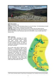
13 <strong>Datganiad</strong> <strong>Cadwraeth</strong> <strong>Clawdd</strong> <strong>Offa</strong><strong>Offa</strong>'s <strong>Dyke</strong> <strong>Conservation</strong> Statement 13y fan hon, i’w gweld ar ffurf arglawdd isel heb ffos. Does dimsôn o’r clawdd yng nghyffiniau Cas-gwent, ond mae rhanohono sydd mewn cyflwr da yn croesi ffos dros ButtingtonTump i ddod i ben ei daith yn y de ger Clogwyni Sedbury.2.6 Cyd-destun y Dirwedd Mae rhan helaeth o’r clawdd ofewn Ardal Harddwch Naturiol Eithriadol Dyffryn Gwy ac maehefyd o fewn yr ardal a ddynodir gan Cadw yn Dirwedd oDdiddordeb Hanesyddol Eithriadol Dyffryn Gwy. Mae’r rhanfwyaf o’r clawdd mewn coetir lled-hynafol sy’n Safle oDdiddordeb Gwyddonol Arbennig (SoDdGA) ac (yngNghoedwig Highbury) sydd wedi ei ddynodi’n WarchodfaNatur Genedlaethol. Ar Gomin Sant Briavel mae’r clawdd wediei integreiddio i’r dirwedd unigryw o lonydd a thyddynnodsydd wedi datblygu, yn ôl pob golwg, trwy broses hanesyddolhir o sgwatwyr yn ymsefydlu ar y comin. Gerllaw Cas-gwent,mae cyd-destun y dirwedd yn fwy trefol. Yn Sedbury, mae’rclawdd yn rhedeg ar hyd ymylon stadau tai o’r 20fed ganrifcyn croesi hen ddarn o barcdir ar ei ben deheuol. Y rhan hono’r clawdd yn Swydd Gaerloyw yw rhan brysuraf Llwybr<strong>Clawdd</strong> <strong>Offa</strong>.— is mostly found as a low bank without a visible ditch. Thedyke has not been traced in the immediate vicinity of Chepstow,and reaches its southern terminus at Sedbury Cliffs via a wellpreservedlength of bank and ditch across Buttington Tump.2.6 Landscape Context Much of the dyke is located withinthe Wye Valley Area Of Outstanding Natural Beauty and isadditionally part of the Cadw registered Lower Wye ValleyLandscape Of Special Historic Interest. The monument islargely under semi-ancient woodland which has Site of SpecialScientific Interest (SSSI) and (in Highbury Woods) NationalNature Reserve status. On St Briavel’s Common the dyke isintegrated into a distinctive landscape of lanes andsmallholdings which appears to have evolved through a longhistorical process of squatter settlement on the common.Close to Chepstow, the landscape context is more urban innature; at Sedbury the dyke fringes 20th-century housingestates before crossing a remnant parkland setting at its farsouthern end. The dyke in Gloucestershire mostly forms theline of what is one of the most heavily used sections of the<strong>Offa</strong>’s <strong>Dyke</strong> Path.Lydbrook i Fryn RushockSwydd Gaerloyw a Swydd Henffordd2.7 Mae 4.5 km o’r llwybr wedi goroesi. Tua’r gogledd, oLydbrook i Fryn Rushock rhyw 50km i ffwrdd, dim ond darnaubychain o Glawdd <strong>Offa</strong> (neu’r hyn a ystyrir yn Glawdd <strong>Offa</strong>)sydd ar ôl. Yn eu plith mae rhannau i’r gorllewin o Henffordd ynBridge Sollars a Yazor, ac ychydig i’r gogledd, y gwrthgloddiauyn Holme Marsh a Lyonshall. Ni wyddys i sicrwydd a yw’rstrwythurau hyn yn wirioneddol yn rhan o Glawdd <strong>Offa</strong>, er eubod yn debyg o ran ffurf i weddill yr henebyn, gydag olionarglawdd amlwg a ffos orllewinol bob yn hyn a hyn.2.8 Cyd-destun y Dirwedd Mae’r clawdd ar WastadeddHenffordd lle ceir amaethyddiaeth ddwys sy’n nodweddbwysig yn lleol. Mae’n drawiadol fel ffin rhwng caeau ac yngoridor i wrychoedd.Lydbrook to Rushock HillGloucestershire and Herefordshire2.7 4.5 km extant. Northwards from Lydbrook to Rushock Hillsome 50 km away, only very short stretches of what isgenerally considered to be <strong>Offa</strong>’s <strong>Dyke</strong> survive. These includethe lengths west of Hereford at Bridge Sollars and Yazor, andfurther north, the earthworks at Holme Marsh and Lyonshall. Itis a matter of academic debate if any of these structures arereally part of <strong>Offa</strong>’s <strong>Dyke</strong>, although they are of comparableform to the rest of the monument, with well-defined bank andwestern ditch remains intermittently preserved.2.8 Landscape Context The dyke occupies the intensivelyfarmed Herefordshire Plain. Where it is present, the earthworkis a locally important feature, and makes a significant physicalimpact as a field boundary and hedgerow corridor.Bryn Rushock i DrefycloSwydd Henffordd a Phowys2.9 Mae 16.1 km o’r llwybr wedi goroesi. Mae’r clawdd ynailgychwyn fel nodwedd parhaus ar Fryn Rushock, ac ynymdroelli tua’r gogledd tuag at Drefyclo ar draws bryniau adyffrynnoedd yr hen sir Faesyfed. Er bod rhannau o’r henebyn— yn enwedig yng ngwaelod y dyffrynnoedd lle ceir gwaithamaethyddol dwys — wedi mynd i ddifancoll, mae’r clawdd ary cyfan yn drawiadol ac wedi cadw’n dda. Mae safle’rgwrthglawdd sylweddol sy’n wynebu’r gorllewin yn Burfa, yRushock Hill to KnightonHerefordshire and Powys2.9 16.1 km extant. The dyke recommences as a morecontinuous feature on Rushock Hill, and twists northwardstowards Knighton across the picturesque hills and valleys ofthe old county of Radnorshire. Although sections of themonument — particularly in the intensively farmed valleybottoms — have been lost, the dyke is generally well preservedand impressive. Notable stretches include the substantiallyconstructed earthwork sited in a commanding west-facing