Datganiad Cadwraeth Clawdd Offa Offa's Dyke Conservation ...
Datganiad Cadwraeth Clawdd Offa Offa's Dyke Conservation ...
Datganiad Cadwraeth Clawdd Offa Offa's Dyke Conservation ...

Create successful ePaper yourself
Turn your PDF publications into a flip-book with our unique Google optimized e-Paper software.
<strong>Datganiad</strong><strong>Cadwraeth</strong><strong>Clawdd</strong> <strong>Offa</strong><strong>Offa</strong>’s <strong>Dyke</strong><strong>Conservation</strong>Statement
Menter <strong>Clawdd</strong> <strong>Offa</strong>, Gorffennaf 2000<strong>Offa</strong>’s <strong>Dyke</strong> Initiative, July 2000TestunCasglwyd ynghyd a’i olygu gan Ian Bapty ar ranPwyllgor Ymgynghorol <strong>Clawdd</strong> <strong>Offa</strong>.TextCompiled and edited by Ian Bapty on behalf of the <strong>Offa</strong>’s<strong>Dyke</strong> Advisory Committee.Menter <strong>Clawdd</strong> <strong>Offa</strong>Cefnogir Menter <strong>Clawdd</strong> <strong>Offa</strong> gan y mudiadaucanlynol, a gynrychiolir ar Bwyllgor Ymgynghorol<strong>Clawdd</strong> <strong>Offa</strong>:Bwrdeistref Sirol WrecsamCadw: Welsh Historic MonumentsCountryside AgencyCyngor Cefn Gwlad CymruCyngor Sir DdinbychCyngor Sir y FflintEnglish HeritageCyngor Swydd GaerloywCyngor Swydd HenfforddGwasanaeth Rheoli Llwybr <strong>Clawdd</strong> <strong>Offa</strong>Parc Cenedlaethol Bannau BrycheiniogCyngor Swydd AmwythigYmddiriedolaeth Archaeolegol Clwyd-Powys<strong>Offa</strong>’s <strong>Dyke</strong> Initiative<strong>Offa</strong>’s <strong>Dyke</strong> Initiative is supported by the followingorganisations who are represented on the <strong>Offa</strong>’s <strong>Dyke</strong>Advisory Committee:Brecon Beacons National ParkCadw: Welsh Historic MonumentsClwyd-Powys Archaeological TrustCountryside AgencyCountryside Council for WalesDenbighshire County CouncilEnglish HeritageFlintshire County CouncilGloucestershire County CouncilHerefordshire County Council<strong>Offa</strong>'s <strong>Dyke</strong> Path Management ServiceShropshire County CouncilWrexham County Borough CouncilAm wybodaeth bellach, cysylltwch ag:Ian BaptySwyddog Rheoli Archaeolegol <strong>Clawdd</strong> <strong>Offa</strong>Ymddiriedolaeth Archaeolegol Clwyd-Powys7a Stryd yr Eglwys Y TrallwngPowysSY21 7DLffôn 01938 553670e-bost IanBapty@cpat.org.ukwww.cpat.org.uk/offa/For further information contact:Ian Bapty<strong>Offa</strong>’s <strong>Dyke</strong> Archaeological Management OfficerClwyd-Powys Archaeological Trust7a Church Street WelshpoolPowysSY21 7DLtel 01938 553670e-mail IanBapty@cpat.org.ukwww.cpat.org.uk/offa/Cymorth ariannolAriennir swydd Swyddog Rheoli Llwybr <strong>Clawdd</strong><strong>Offa</strong> ar y cyd gan Cadw: Welsh Historic Monumentsa English Heritage.Financial assistanceThe <strong>Offa</strong>’s <strong>Dyke</strong> Archaeological Management Officer’spost is jointly funded by Cadw: Welsh Historic Monumentsand English Heritage.
<strong>Datganiad</strong><strong>Cadwraeth</strong><strong>Clawdd</strong> <strong>Offa</strong><strong>Offa</strong>’s <strong>Dyke</strong><strong>Conservation</strong>Statement‘ac yna perodd <strong>Offa</strong> i glawdd gaeli godi . . . o’r enw <strong>Clawdd</strong> <strong>Offa</strong>o’r dydd hwnnw hyd heddiw’‘and then <strong>Offa</strong> had a dyke made. . . that was called <strong>Offa</strong>’s <strong>Dyke</strong>from that day to this’
4 <strong>Datganiad</strong> <strong>Cadwraeth</strong> <strong>Clawdd</strong> <strong>Offa</strong><strong>Offa</strong>'s <strong>Dyke</strong> <strong>Conservation</strong> Statement 4CynnwysContentsCrynodeb Gweithredol .................................................. 3Cyflwyniad ................................................................... 7<strong>Clawdd</strong> <strong>Offa</strong> heddiw .................................................... 10Hanes <strong>Clawdd</strong> <strong>Offa</strong> .................................................... 15Arwyddocâd <strong>Clawdd</strong> <strong>Offa</strong> ........................................... 23Achosion erydiad ....................................................... 25<strong>Cadwraeth</strong> <strong>Clawdd</strong> <strong>Offa</strong> .............................................. 29Egwyddorion cadwraeth ............................................. 33Fframweithiau rheoli ................................................... 36Casgliadau ................................................................. 39Ffynonellau ................................................................ 40Executive Summary ..................................................... 3Introduction .................................................................. 7<strong>Offa</strong>'s <strong>Dyke</strong> today....................................................... 10The history of <strong>Offa</strong>’s <strong>Dyke</strong> .......................................... 15The significance of <strong>Offa</strong>'s <strong>Dyke</strong> .................................. 23Causes of erosion ...................................................... 25Conserving <strong>Offa</strong>’s <strong>Dyke</strong> .............................................. 29<strong>Conservation</strong> principles .............................................. 33Management frameworks ........................................... 36Conclusions ............................................................... 39Sources ..................................................................... 40
5 <strong>Datganiad</strong> <strong>Cadwraeth</strong> <strong>Clawdd</strong> <strong>Offa</strong><strong>Offa</strong>'s <strong>Dyke</strong> <strong>Conservation</strong> Statement 5Crynodeb GweithredolExecutive SummaryDiben y <strong>Datganiad</strong> <strong>Cadwraeth</strong>1 Ffin o bridd rhyw 1200 mlwydd oed yw <strong>Clawdd</strong> <strong>Offa</strong>.Mae’n rhedeg am oddeutu 129 km ar hyd y gororau. Mae’rcyfuniad o faint daearyddol, sensitifrwydd archaeolegol achyd-destun tirwedd <strong>Clawdd</strong> <strong>Offa</strong> yn golygu bod cadwraethyn sialens gymhleth, tymor hir.2 Cam cyntaf yn y dasg o lunio ateb i’r sefyllfa yw’r<strong>Datganiad</strong> <strong>Cadwraeth</strong> yma. Mae’n cynnig arfarniad o gymeriada phwysigrwydd <strong>Clawdd</strong> <strong>Offa</strong> a’r egwyddorion cadwraeth fyddyn helpu i ddiogelu’r clawdd ar gyfer y dyfodol.3 Mae’r sefydliadau craidd sy’n ymwneud â rheoli <strong>Clawdd</strong><strong>Offa</strong> yn cydnabod y <strong>Datganiad</strong> <strong>Cadwraeth</strong> hwn yn ffurfiol.Fe fydd y datganiad yn cael ei ddefnyddio i gefnogi ac iysgogi ymgynghoriad pellach, a’r prosesau datblyguprosiectau a chodi arian angenrheidiol er mwyn sicrhaucadwraeth parhaus yr henebyn hwn o bwys cenedlaethol.Purpose of the <strong>Conservation</strong> Statement1 <strong>Offa</strong>’s <strong>Dyke</strong> is a 1200-year-old earthen boundary whichruns for 129 km through the borderland of Wales and England.The combined geographical scale, archaeological sensitivity,and modern landscape context of <strong>Offa</strong>’s <strong>Dyke</strong> means that itsconservation is a complex long-term challenge.2 This <strong>Conservation</strong> Statement is a first step in addressingthis situation. It provides an initial appraisal of the characterand importance of <strong>Offa</strong>’s <strong>Dyke</strong> and the conservation principleswhich will help to preserve the dyke for the future.3 The <strong>Conservation</strong> Statement has been formally endorsedby the core organisations involved in the management of<strong>Offa</strong>’s <strong>Dyke</strong>. It will be used to support and initiate the furtherconsultation, project development and fund-raising processesnecessary to realise the ongoing conservation of thisnationally important ancient monument.Arwyddocâd <strong>Clawdd</strong> <strong>Offa</strong>4 <strong>Clawdd</strong> <strong>Offa</strong> yw henebyn archaeolegol hwyaf Prydain.Mae’n ymestyn am 129 km ar hyd y gororau o Dreuddyn(ger Wrecsam yng ngogledd ddwyrain Cymru) i GlogwyniSedbury (ar aber Afon Hafren yn ne Sir Gaerloyw).Arglawdd hyd at 8 metr o uchder gyda ffos ddofn ar yr ochrorllewinol sydd i’w gweld heddiw.5 Credir mai <strong>Offa</strong>, Brenin teyrnas Eingl-Sacsonaidd y Mers ynyr 8fed ganrif, oedd yn gyfrifol am godi’r gwrthglawdd hynodyma. Byddwn yn dehongli hyn fel rheol fel ffin a rhwystramddiffynnol rhwng y Mers a’r teyrnasoedd Prydeinig(Cymreig) annibynnol yn yr ardal sydd bellach yn cael ei galw’nGymru.6 Mae <strong>Clawdd</strong> <strong>Offa</strong> yn dirnod amlwg ac unigryw yn yr ardal, adefnyddir ef bellach i nodi ffin gyfoes rhwng y ddwy wlad, rhwngplwyfi, rhwng caeau, neu rhwng tiroedd gwahanol berchnogion.Ysgogodd y clawdd y penderfyniad i greu Llwybr <strong>Clawdd</strong> <strong>Offa</strong>(un o brif lwybrau troed hir ‘Llwybrau Cenedlaethol’ Prydain), acmae’r llwybr yn dilyn 55km y gwrthglawdd yn uniongyrchol.7 Mae <strong>Clawdd</strong> <strong>Offa</strong> yn un o’r henebion archaeolegol pwysicafyng Ngorllewin Ewrop, ac yn dystiolaeth unigryw i darddiad yCymry a’r Saeson. Oherwydd ei werth presennol fel amwyndera’i werth diwylliannol, ecolegol a gweledol, mae hefyd yn rhanallweddol o dirwedd gyfoes y Gororau. Yn arbennig, mae<strong>Clawdd</strong> <strong>Offa</strong> yn:• henebyn sy’n cysylltu cymunedau heddiw â gwreiddiaudiwylliannol a hanesyddol y Cymry a’r Saeson mewn dullreal ac unigryw, ac sy’n dystiolaeth hanfodol wrth geisioSignificance of <strong>Offa</strong>’s <strong>Dyke</strong>4 <strong>Offa</strong>’s <strong>Dyke</strong> is Britain’s longest archaeological monument,stretching for 129 km through the Welsh borders fromTreuddyn (near Wrexham in north east Wales) to SedburyCliffs (on the Severn estuary, in southern Gloucestershire).The surviving dyke typically consists of a bank which can beup to 8 metres high associated with a deep western ditch.5 This extraordinary earthwork is believed to have been builtin the 8th century AD by King <strong>Offa</strong> of the ancient Anglo-Saxon kingdom of Mercia and is usually interpreted as aboundary and defensive barrier between Mercia and theindependent British (Welsh) kingdoms then existing in what isnow Wales.6 <strong>Offa</strong>’s <strong>Dyke</strong> today is a prominent and locally distinctivelandmark often serving as a modern national, parish,ownership or field boundary. The creation of the <strong>Offa</strong>’s <strong>Dyke</strong>Path (one of Britain’s premier ‘National Trail’ long distancefootpaths) was inspired by the dyke, and the route directlyfollows 55 km of the earthwork.7 <strong>Offa</strong>’s <strong>Dyke</strong> is one of the most important archaeologicalmonuments in Western Europe, and unique evidence of theorigins of the Welsh and English people. Via its contemporarycultural, ecological, visual and amenity value, it is also a keypart of today’s Marches landscape. In particular, <strong>Offa</strong>’s <strong>Dyke</strong>is:• a monument which tangibly and uniquely connectspresent day communities with the cultural and historicalorigins of the Welsh and English peoples, and is a crucial
6 <strong>Datganiad</strong> <strong>Cadwraeth</strong> <strong>Clawdd</strong> <strong>Offa</strong><strong>Offa</strong>'s <strong>Dyke</strong> <strong>Conservation</strong> Statement 6deall y gwreiddiau hynny• cyflawniad technegol a threfniadol hynod, o’r math a’rmaint daearyddol heb ei ail yn Ewrop, yn ei gyfnod eihunan nac yn y 1000 mlynedd dilynol hyd at y ChwyldroDiwydiannol• henebyn sydd, yng nghyd-destun deall hanes Eingl-Sacsonaidd, yn rhoi cipolwg archaeolegol allweddol argyfraniad <strong>Offa</strong> a theyrnas y Mers i ddatblygiad cyfnoddiweddarach ym Mhrydain• nodwedd gyfeiriadol archaeolegol unigryw yn nhirweddleol y Gororau• nodwedd archaeolegol unigryw o’r dirwedd sy’n gwneudcyfraniad gweledol a ffisegol sylfaenol i gymeriad a nawsbenodol yr ardal o gwmpas• ffin gyfoes bwysig a rhan annatod o’r dirweddamaethyddol sy’n cael ei gweithio; dyma amgylcheddpennaf y clawdd• llain o dirwedd wledig ddigyffro sydd o werth pwysig osafbwynt bywyd gwyllt ac ecoleg• atyniad pwysig i ymwelwyr â’r Gororau, gyda gwertheconomaidd arwyddocaol i gymunedau lleol (yngysylltiedig â Llwybr <strong>Clawdd</strong> <strong>Offa</strong> yn bennaf).piece of evidence in understanding those origins• a remarkable technical and organisational achievementof a kind and geographical scale which was withoutequal in Europe either in its own time or in the following1000 years up to the Industrial Revolution• a monument which, in the context of understandingBritish history, gives a key archaeological insight intothe contribution of <strong>Offa</strong> and the Anglo-Saxon kingdom ofMercia to the later development of Britain• a unique archaeological reference point in the localMarches landscape• a highly distinctive landscape feature which makes afundamental visual and physical contribution to theparticular character and feel of its local surroundings• an important modern boundary and an integral part ofthe actively managed agricultural landscape which itmostly occupies• a largely undisturbed rural landscape corridor whichhas important wildlife and ecological value• an important Marches visitor attraction with significanteconomic value to local communities (linked primarily tothe <strong>Offa</strong>’s <strong>Dyke</strong> Path)Problemau <strong>Cadwraeth</strong>8 Mae <strong>Clawdd</strong> <strong>Offa</strong>’n wynebu llawer o bwysau o ran ei barhadyn y tymor hir. Cafodd llawer ohono ei ddinistrio neu eiddifrodi’n ddifrifol dros y canrifoedd ac mae hyn yn parhau hydheddiw. Mae arolygon diweddar yn dangos bod 30% o’r clawddyn erydu ar hyn o bryd.9 Mae materion amaethyddol fel gorbori ac aredig, anawsterausy’n gysylltiedig ag ymwelwyr â Llwybr <strong>Clawdd</strong> <strong>Offa</strong>, tyllau agloddiwyd gan anifeiliaid a datblygiadau modern ymhlith yrhesymau mwyaf cyffredin am yr erydu.10 I sicrhau cadwraeth gynaliadwy ar Glawdd <strong>Offa</strong>, rhaid deallperthynas gymhleth y clawdd â’i gyd-destun yn y dirweddgyfoes, yn ogystal â cheisio datrys y problemau ymarferol hynyn uniongyrchol.<strong>Conservation</strong> Problems8 <strong>Offa</strong>’s <strong>Dyke</strong> faces many pressures on its long-termsurvival. Over the centuries, much of the monument has beendestroyed or seriously damaged, and that process goes ontoday. Recent surveys have indicated that 30% of the dyke iscurrently suffering active erosion.9 Common identified causes of erosion range fromagricultural issues, such as over-grazing and ploughing, tovisitor access linked to the <strong>Offa</strong>’s <strong>Dyke</strong> Path, digging byburrowing animals and modern development.10 The sustainable conservation of <strong>Offa</strong>’s <strong>Dyke</strong> involves notjust directly addressing these practical problems, but alsounderstanding the complicated relationship of the dyke to itsmodern landscape context.Egwyddorion <strong>Cadwraeth</strong>11 Rhaid seilio cadwraeth <strong>Clawdd</strong> <strong>Offa</strong> ar egwyddorion eglur<strong>Conservation</strong> Principles11 The conservation of <strong>Offa</strong>’s <strong>Dyke</strong> must be based on clear
7 <strong>Datganiad</strong> <strong>Cadwraeth</strong> <strong>Clawdd</strong> <strong>Offa</strong><strong>Offa</strong>'s <strong>Dyke</strong> <strong>Conservation</strong> Statement 7sy’n adlewyrchu dealltwriaeth lawn o arwyddocâd yrhenebyn ac yn diffinio sail glir ar gyfer dull integredig o’ireoli yn y tymor hir. Dyma’r egwyddorion cadwraeth aawgrymwn:• sicrhau bod cynigion rheoli <strong>Clawdd</strong> <strong>Offa</strong> yn gwarantuamddiffyniad cynaliadwy’r gwrthglawdd, ac yn ystyried yrholl agweddau ar arwyddocâd y clawdd• ceisio datblygu partneriaeth a chonsensws ymhlith yrholl sefydliadau, boed yn gyhoeddus neu’n breifat, sy’nymwneud â rheoli <strong>Clawdd</strong> <strong>Offa</strong>• cysylltu cadwraeth <strong>Clawdd</strong> <strong>Offa</strong> yn y tymor hir ynymarferol â phrosesau cyfredol a pharhaus o reoli tir• datblygu amddiffyniad tirwedd <strong>Clawdd</strong> <strong>Offa</strong> yn ogystalâ’r henebyn ffisegol ei hun• hwyluso gwell gwybodaeth ar gyfer rheoli <strong>Clawdd</strong> <strong>Offa</strong>trwy gyfrwng dealltwriaeth archaeolegol a hanesyddolo’r henebyn• hybu ymwybyddiaeth a gwerthfawrogiad y cyhoedd oGlawdd <strong>Offa</strong> fel nodwedd o bwys hanesyddol a chyfoes• annog cyfranogiad cyhoeddus o safbwynt rheoli<strong>Clawdd</strong> <strong>Offa</strong>• defnyddio’r adnoddau cyhoeddus a phreifat i’r eithaf iwella a rheoli <strong>Clawdd</strong> <strong>Offa</strong>.principles which reflect a full understanding of thesignificance of the monument and define a clear basis for anintegrated approach to its long-term management. Thesuggested conservation principles are as follows:• ensure management proposals for <strong>Offa</strong>’s <strong>Dyke</strong> guaranteethe sustainable protection of the earthwork and take intoaccount all aspects of the dyke’s significance• seek to develop partnership and consensus among allthose, public or private, involved in the management of<strong>Offa</strong>’s <strong>Dyke</strong>• pragmatically link the long-term conservation of <strong>Offa</strong>’s<strong>Dyke</strong> to existing and ongoing land management processes• develop the protection of the landscape setting of <strong>Offa</strong>’s<strong>Dyke</strong> as well as just the physical monument itself• facilitate more informed management of <strong>Offa</strong>’s <strong>Dyke</strong>through better archaeological and historicalunderstanding of the monument• promote awareness and appreciation of <strong>Offa</strong>’s <strong>Dyke</strong> as afeature of historic and contemporary importance• encourage public participation in the management of<strong>Offa</strong>’s <strong>Dyke</strong>• maximise public and private resources for theenhancement and management of <strong>Offa</strong>’s <strong>Dyke</strong>Fframweithiau Rheoli12 Mae llawer o Glawdd <strong>Offa</strong> yn cael ei amddiffyn ynstatudol fel Henebyn Rhestredig yng Nghymru a Lloegr. MaeMenter <strong>Clawdd</strong> <strong>Offa</strong> yn gweithredu cynlluniau cadwraethymarferol ar y clawdd ac yn cydlynu datblygiad strategaethcadwraeth tymor hir ar gyfer yr henebyn. Cadw ac EnglishHeritage sy’n ariannu’r fenter hon, ac YmddiriedolaethArchaeolegol Clwyd-Powys sy’n ei rheoli. Bydd AwdurdodauLleol y chwech ardal y mae’r clawdd yn eu croesi hefyd ynymwneud yn agos â’r rheolaeth archaeolegol a’r rheolaethehangach arno.13 Yr awdurdodau rheoli perthnasol (yr Awdurdodau Lleola’r Awdurdodau Parciau Cenedlaethol), mewn partneriaeth âChyngor Cefn Gwlad Cymru a’r Countryside Agency, sy’ngyfrifol am ofalu am Lwybr Cenedlaethol <strong>Clawdd</strong> <strong>Offa</strong>, ac am eiddatblygu.14 Mae Pwyllgor Rheoli Llwybr <strong>Clawdd</strong> <strong>Offa</strong> yn cydlynu’rManagement Frameworks12 Much of <strong>Offa</strong>’s <strong>Dyke</strong> is statutorily protected as aScheduled Ancient Monument in England and Wales. The<strong>Offa</strong>’s <strong>Dyke</strong> Initiative, funded by Cadw: Welsh HistoricMonuments and English Heritage and managed by the Clwyd-Powys Archaeological Trust, is implementing practicalconservation schemes on the dyke and coordinating thedevelopment of a long-term conservation strategy for themonument. The six Local Authorities crossed by the dyke arealso closely involved in its archaeological and widermanagement.13 The care and development of the <strong>Offa</strong>’s <strong>Dyke</strong> NationalTrail is undertaken by the relevant managing authorities (theLocal Authorities and National Park Authorities) inpartnership with the Countryside Council for Wales and theCountryside Agency.14 The overall management process is collectively
8 <strong>Datganiad</strong> <strong>Cadwraeth</strong> <strong>Clawdd</strong> <strong>Offa</strong><strong>Offa</strong>'s <strong>Dyke</strong> <strong>Conservation</strong> Statement 8broses reoli gyffredinol, ar y cyd â Phwyllgor Ymgynghorol<strong>Clawdd</strong> <strong>Offa</strong> sydd â ffocws archaeolegol.coordinated by the <strong>Offa</strong>’s <strong>Dyke</strong> Path Management Committeeand the archaeologically focused <strong>Offa</strong>’s <strong>Dyke</strong> AdvisoryCommittee.Casgliadau15 Henebyn unigryw o bwys cenedlaethol yw <strong>Clawdd</strong> <strong>Offa</strong>.Mae iddo arwyddocâd sy’n cysylltu archaeoleg, hanes,diwylliant, tirwedd, ecoleg, amwynder ac economeg. Mae’rcategorïau o arwyddocâd eto i’w cloriannu yn briodol a’upwyso yn erbyn ei gilydd mewn termau rheoli manwl, ynenwedig o ran strategaeth gadwraeth gyfun ar gyfer yrhenebyn cyfan.16 Mae pwysau cynyddol ar oroesiad y clawdd o ran eiarchaeoleg a’i hunaniaeth unigryw. O ystyried maint achymhlethdod yr henebyn o ran tirwedd, mae’r dirywiad yndebygol o fod yn sylweddol ac yn barhaus oni bai ein bod yngweithredu rhaglen gadwraeth integredig sy’n canolbwyntio ar ymaterion priodol.17 Dylid seilio rheolaeth barhaus <strong>Clawdd</strong> <strong>Offa</strong> aregwyddorion cadwraeth clir, ac fe fydd gofyn ymwneudeffeithiol amrywiaeth eang o bartneriaid, asesiad achytundeb clir ar dargedau rheoli a chefnogaeth ariannolarwyddocaol.Conclusions15 <strong>Offa</strong>’s <strong>Dyke</strong> is a unique and nationally important ancientmonument with interconnected archaeological, historical,cultural, landscape, ecological, amenity and economicsignificance. Those categories of significance are yet to beproperly evaluated and weighed against one another indetailed management terms, particularly with respect to anintegrated conservation strategy for the whole monument.16 <strong>Offa</strong>’s <strong>Dyke</strong> is subject to increasing pressures on thesurvival of its archaeological fabric and distinctive identity,and, given the scale and landscape complexity of themonument, is likely to continue to suffer substantial andongoing degradation unless a well focused, integrated andsustained conservation programme is implemented.17 The ongoing management of <strong>Offa</strong>’s <strong>Dyke</strong> should bebased on clear conservation principles and will requireeffective involvement of a wide range of partners, clearassessment and agreement of management targets andsignificant funding support.Y Camau nesaf18 Yn dilyn y <strong>Datganiad</strong> <strong>Cadwraeth</strong> yma, mae’r camau nesafyn cynnwys:• ymgynghoriad pellach gyda grwpiau a mudiadauperthnasol• comisiynu Cynllun <strong>Cadwraeth</strong> manylach ar gyfer <strong>Clawdd</strong><strong>Offa</strong>• datblygu mentrau codi arian i gefnogi’r broses reolihirdymor19 Mae dechrau hybu <strong>Clawdd</strong> <strong>Offa</strong> fel henebyn â StatwsTreftadaeth y Byd posibl hefyd yn gynnig ychwanegol. Syniadtymor hir yw hwn, ac er ein bod yn ei grybwyll yma, nid yw hynyn golygu bod English Heritage, Cadw na phartneriaid eraill yncefnogi cynnig o’r fath ar hyn o bryd.Next Steps18 Following on from this <strong>Conservation</strong> Statement,suggested steps forward include:• further consultation with relevant groups andorganisations• commissioning a more detailed <strong>Conservation</strong> Plan for<strong>Offa</strong>’s <strong>Dyke</strong>• developing fund-raising initiatives to support the longtermmanagement process19 An additional suggestion is to begin to promote <strong>Offa</strong>’s<strong>Dyke</strong> as a monument of potential World Heritage Site status.This is a long term idea, and its mentin here does not indicateEnglish Heritage, Cadw: Welsh Historic Monuments or otherpartner support for such a proposal at this stage.
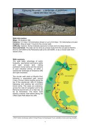
9 <strong>Datganiad</strong> <strong>Cadwraeth</strong> <strong>Clawdd</strong> <strong>Offa</strong><strong>Offa</strong>'s <strong>Dyke</strong> <strong>Conservation</strong> Statement 9Cyflwyniad1 IntroductionYngl~n â’r ddogfen hon1.1 Ffin o bridd rhyw 1200 mlwydd oed yw <strong>Clawdd</strong> <strong>Offa</strong>.Mae’n rhedeg am oddeutu 129 km ar hyd y gororau. Mae’rcyfuniad o faint daearyddol, sensitifrwydd archaeolegol achyd-destun tirwedd <strong>Clawdd</strong> <strong>Offa</strong> yn golygu bod cadwraeth ynsialens gymhleth, tymor hir.1.2 Cam cyntaf yn y dasg o lunio ateb i’r sefyllfa yw’r<strong>Datganiad</strong> <strong>Cadwraeth</strong> yma. Ei amcan craidd yw cynnig arfarniado gymeriad a phwysigrwydd <strong>Clawdd</strong> <strong>Offa</strong>. Mae’r <strong>Datganiad</strong>hefyd yn amlinellu’r pwysau dinistriol cyfoes sy’n effeithio ar ygwrthglawdd, ac yn ceisio awgrymu’r egwyddorion cadwraethy mae angen eu mabwysiadu er mwyn diogelu’r clawdd a hollagweddau ei arwyddocâd ar gyfer y dyfodol.1.3 Y gobaith yw y bydd y sefydliadau craidd sy’n ymwneudâ rheoli <strong>Clawdd</strong> <strong>Offa</strong> yn cydnabod y <strong>Datganiad</strong> <strong>Cadwraeth</strong> hwnyn ffurfiol. Fe fydd yn cael ei ddefnyddio i gefnogi ac i ysgogiymgynghoriad pellach, a’r prosesau datblygu prosiectau achodi arian angenrheidiol er mwyn sicrhau cadwraeth parhausyr henebyn hynod hwn.About this document1.1 <strong>Offa</strong>’s <strong>Dyke</strong> is a 1200-year-old earthen boundary whichruns for 129 km through the borderland of Wales and England.The combined geographical scale, archaeological sensitivity,and modern landscape context of <strong>Offa</strong>’s <strong>Dyke</strong> means that itsconservation is a complex long-term challenge.1.2 This <strong>Conservation</strong> Statement is a first step in addressingthis situation. Its core objective is to offer an initial appraisalof the character and importance of <strong>Offa</strong>’s <strong>Dyke</strong>. The Statementalso outlines the modern destructive pressures acting on theearthwork, and aims to suggest the conservation principleswhich need to be adopted to preserve the dyke and all aspectsof its significance for the future.1.3 The <strong>Conservation</strong> Statement has been formally endorsedby the core organisations involved in the management of<strong>Offa</strong>’s <strong>Dyke</strong>. It will be used to support and initiate the furtherconsultation, project development and fund-raising processesnecessary to realise the ongoing conservation of thisnationally important ancient monument.Beth yw <strong>Clawdd</strong> <strong>Offa</strong>?1.4 Henebyn archaeolegol hwyaf Prydain yw <strong>Clawdd</strong> <strong>Offa</strong>.Gwrthglawdd unionlin hynod ydyw sy’n rhedeg trwy’r Gororauo Dreuddyn (ger Wrecsam yng ngogledd-ddwyrain Cymru) iGlogwyni Sedbury (ger aber Afon Hafren, yn ne SwyddGaerloyw). Credir mai Brenin <strong>Offa</strong> o deyrnas Eingl-Sacsonaiddy Mers oedd yn gyfrifol am godi’r clawdd yn yr 8fed ganrif felffin a rhwystr amddiffynnol rhwng y Mers a’r teyrnasoeddPrydeinig (Cymreig) annibynnol yn yr ardal sydd bellach yncael ei galw’n Gymru.1.5 Hyd yn oed yn ôl safonau heddiw mae <strong>Clawdd</strong> <strong>Offa</strong>’ngamp adeiladol trawiadol. Roedd o leiaf 129 km wedi’i godi arffin oedd unwaith yn 240 km o hyd o bosibl. Arglawdd hyd at 8metr o uchder â ffos ddofn ar yr ochr orllewinol sydd i’w gweldheddiw.1.6 Mae <strong>Clawdd</strong> <strong>Offa</strong> yn dirnod amlwg ac unigryw yn yr ardal, adefnyddir ef bellach i nodi ffin gyfoes rhwng y ddwy wlad, rhwngplwyfi, rhwng caeau, neu rhwng tiroedd gwahanol berchnogion.Ysgogodd y clawdd y penderfyniad i greu Llwybr <strong>Clawdd</strong> <strong>Offa</strong> (uno brif lwybrau troed hir ‘Llwybrau Cenedlaethol’ Prydain), ac mae’rllwybr yn dilyn 55km y gwrthglawdd yn uniongyrchol.What is <strong>Offa</strong>’s <strong>Dyke</strong>?1.4 <strong>Offa</strong>’s <strong>Dyke</strong> is Britain’s longest archaeologicalmonument, a remarkable linear earthwork which runs throughthe borderlands of Wales and England from Treuddyn (nearWrexham in north east Wales) to Sedbury Cliffs (on theSevern estuary, in southern Gloucestershire). The dyke isbelieved to have been built in the 8th century AD by King<strong>Offa</strong> of the Anglo-Saxon kingdom of Mercia as a boundaryand defensive barrier between Mercia and the independentBritish kingdoms then existing in what is now Wales.1.5 Even by modern standards, <strong>Offa</strong>’s <strong>Dyke</strong> is a strikinglyimpressive constructional achievement. At least 129 km of dykeis known to have existed on what may once have been a 240 kmfrontier line, with the surviving monument consisting of a bankup to 8 metres high associated with a deep western ditch.1.6 <strong>Offa</strong>’s <strong>Dyke</strong> is a prominent and locally distinctive landmarkoften serving as a modern national, parish, ownership or fieldboundary. The creation of the <strong>Offa</strong>’s <strong>Dyke</strong> Path (one of Britain’spremier ‘National Trail’ long distance footpaths) was inspiredby the dyke, and the route directly follows 55 km of theearthwork.Cynlluniau a <strong>Datganiad</strong>au <strong>Cadwraeth</strong>1.7 Cododd y cysyniad o ‘ Gynllun <strong>Cadwraeth</strong>’ a ‘<strong>Datganiad</strong><strong>Conservation</strong> Plans and Statements1.7 The concept of the ‘<strong>Conservation</strong> Plan’ and related
10 <strong>Datganiad</strong> <strong>Cadwraeth</strong> <strong>Clawdd</strong> <strong>Offa</strong><strong>Offa</strong>'s <strong>Dyke</strong> <strong>Conservation</strong> Statement 10<strong>Cadwraeth</strong>’ yn sgîl ceisio nawdd Cronfa Treftadaeth y Loteri(CTL).1.8 Yn ôl canllawiau’r CTL (tudalen 3) mae Cynlluniau<strong>Cadwraeth</strong> yn helpu i ddangos dealltwriaeth o holl agweddau’rased ac y bydd y pwysigrwydd hwn yn cael ei gadw. Maebellach angen Cynllun <strong>Cadwraeth</strong> cyn llunio cynllun rheolimanwl neu gynnig prosiect penodol, ac mae English Heritageyn argymell hwn fel offeryn rheoli treftadaeth, p’un a yw’ngysylltiedig â chais am CTL ai peidio.1.9 Defnyddir <strong>Datganiad</strong> <strong>Cadwraeth</strong> fel cam cyntaf wrthasesu safle yn llai manwl. Nid yw’n galw am ymchwil newyddna’r gwaith arbenigol manwl y mae galw amdano wrth lunioCynllun <strong>Cadwraeth</strong>. O’r herwydd, mae’r <strong>Datganiad</strong> <strong>Cadwraeth</strong>yn cynnig golwg ragarweiniol ar arwyddocâd strwythurhanesyddol ac amlinelliad darpariaethol o’r egwyddorioncadwraeth sy’n berthnasol i’r henebyn hwnnw. Gellir eiddefnyddio i godi ymwybyddiaeth sefydliadau perthnasol abuddgarfanau o’r materion rheoli allai godi. Gellir ei ddefnyddiohefyd i helpu wrth ddiffinio cwmpas Cynllun <strong>Cadwraeth</strong> llawn.‘<strong>Conservation</strong> Statement’ has emerged from the HeritageLottery Fund (HLF) application process.1.8 According to the HLF guidance (page 3) ‘<strong>Conservation</strong>Plans help to demonstrate . . . a clear understanding of allaspects of the asset and that this importance will be retained’ .A <strong>Conservation</strong> Plan stands before a detailed managementplan or a particular project proposal, and is now advocated byEnglish Heritage as a fundamental tool of heritagemanagement whether or not linked to an HLF application.1.9 A <strong>Conservation</strong> Statement is a more basic ‘first stop’site assessment without the new research and detailedspecialist input which a full <strong>Conservation</strong> Plan involves. Assuch a <strong>Conservation</strong> Statement offers a preliminary view ofthe significance of a historic structure and a provisionaloutline of the conservation principles applicable to thatmonument. It may be used to raise awareness of potentialmanagement issues among relevant organisations andinterested parties as well as to help define the scope of afull <strong>Conservation</strong> Plan.Pam fod angen <strong>Datganiad</strong> <strong>Cadwraeth</strong>1.10 Mae arolygon cyflwr archaeolegol dros y degawddiwethaf wedi dangos bod difrod difrifol a pharhaus oganlyniad i erydiad ar hyd llawer o Glawdd <strong>Offa</strong>. MaeEnglish Heritage a Cadw wedi noddi ‘Menter <strong>Clawdd</strong> <strong>Offa</strong>’yn ddiweddar mewn ymateb i’r sefyllfa yma. Prosiect ywhwn sy’n ceisio hwyluso cynlluniau rheoli ymarferol ar yclawdd, a llunio dull strategol tymor hir o drin cadwraeth yrhenebyn.1.11 Canlyniad dilyniant cymhleth o ddatblyguhanesyddol yw <strong>Clawdd</strong> <strong>Offa</strong>, fel y gwelwn ef heddiw. Maeyna angen clir i ddechrau diffinio’r holl elfennau sy’ngwneud y clawdd yn henebyn gwerthfawr, cyn y gallwnlunio polisi rheolaeth cytbwys ac integredig. Hefyd maeangen sefydlu egwyddorion cadwraeth priodol i’wdefnyddio wrth gynnal cymeriad arbennig yr henebynhynod hwn. Mae proses ddadansoddol o’r fath hefyd yngalw am ddealltwriaeth drylwyr o gyd-destun cyfoes yclawdd a natur y pwysau erydu sy’n effeithio arno.Why a <strong>Conservation</strong> Statement is needed1.10 Archaeological condition surveys over the last decadehave shown that <strong>Offa</strong>’s <strong>Dyke</strong> is suffering serious and ongoingerosion damage along much of its length. In response to thissituation English Heritage and Cadw: Welsh HistoricMonuments have recently funded ‘The <strong>Offa</strong>’s <strong>Dyke</strong> Initiative’,a project aiming both to facilitate practical managementschemes on the dyke and to pull together a longer-termstrategic approach to the conservation of the monument.1.11 <strong>Offa</strong>’s <strong>Dyke</strong> as it appears today is the end result of acomplex sequence of historical development. There is anevident need, before a more rounded and integratedmanagement policy can be formulated, to begin to define allthe elements which make the dyke valuable, and to establishappropriate conservation principles against which the specialcharacter of this highly distinctive monument can bemaintained. Such an analytical process also requires athorough understanding of the contemporary context of thedyke and the nature of the erosion pressures acting upon it.Cynnwys y <strong>Datganiad</strong> <strong>Cadwraeth</strong>1.12 Mae’r <strong>Datganiad</strong> <strong>Cadwraeth</strong> yma’n cyflawni’r canlynol:• mae’n crynhoi ein dealltwriaeth o bwysigrwyddarchaeolegol a hanesyddol, ac arwyddocâd ehangach<strong>Clawdd</strong> <strong>Offa</strong>The contents of the <strong>Conservation</strong> Statement1.12 This <strong>Conservation</strong> Statement fulfils the following:• it summarises our understanding of the archaeological,historical and wider significance of <strong>Offa</strong>’s <strong>Dyke</strong>
11 <strong>Datganiad</strong> <strong>Cadwraeth</strong> <strong>Clawdd</strong> <strong>Offa</strong><strong>Offa</strong>'s <strong>Dyke</strong> <strong>Conservation</strong> Statement 11• mae’n amlinellu problemau cadwraeth a materion eraillsy’n wynebu <strong>Clawdd</strong> <strong>Offa</strong>• mae’n awgrymu’r egwyddorion cadwraeth craidd y dylideu defnyddio yn sail i reolaeth <strong>Clawdd</strong> <strong>Offa</strong>• mae’n nodi man cychwyn lle gellir dechrau datblygustrategaeth cadwraeth tymor hir ar gyfer <strong>Clawdd</strong> <strong>Offa</strong>. Fefydd hon yn ei thro yn cyfuno’n briodol materionarchaeoleg, tirwedd, ecoleg, ymwneud y cyhoedd,mynediad y cyhoedd ac economeg.• it outlines the conservation problems and issues facing<strong>Offa</strong>’s <strong>Dyke</strong>• it suggests core conservation principles against whichthe management of <strong>Offa</strong>’s <strong>Dyke</strong> should be set• it identifies a starting point from which a long-termconservation strategy for <strong>Offa</strong>’s <strong>Dyke</strong> can be developedwhich will properly integrate archaeological, landscape,ecological, public involvement, public access andeconomic issues.
13 <strong>Datganiad</strong> <strong>Cadwraeth</strong> <strong>Clawdd</strong> <strong>Offa</strong><strong>Offa</strong>'s <strong>Dyke</strong> <strong>Conservation</strong> Statement 13y fan hon, i’w gweld ar ffurf arglawdd isel heb ffos. Does dimsôn o’r clawdd yng nghyffiniau Cas-gwent, ond mae rhanohono sydd mewn cyflwr da yn croesi ffos dros ButtingtonTump i ddod i ben ei daith yn y de ger Clogwyni Sedbury.2.6 Cyd-destun y Dirwedd Mae rhan helaeth o’r clawdd ofewn Ardal Harddwch Naturiol Eithriadol Dyffryn Gwy ac maehefyd o fewn yr ardal a ddynodir gan Cadw yn Dirwedd oDdiddordeb Hanesyddol Eithriadol Dyffryn Gwy. Mae’r rhanfwyaf o’r clawdd mewn coetir lled-hynafol sy’n Safle oDdiddordeb Gwyddonol Arbennig (SoDdGA) ac (yngNghoedwig Highbury) sydd wedi ei ddynodi’n WarchodfaNatur Genedlaethol. Ar Gomin Sant Briavel mae’r clawdd wediei integreiddio i’r dirwedd unigryw o lonydd a thyddynnodsydd wedi datblygu, yn ôl pob golwg, trwy broses hanesyddolhir o sgwatwyr yn ymsefydlu ar y comin. Gerllaw Cas-gwent,mae cyd-destun y dirwedd yn fwy trefol. Yn Sedbury, mae’rclawdd yn rhedeg ar hyd ymylon stadau tai o’r 20fed ganrifcyn croesi hen ddarn o barcdir ar ei ben deheuol. Y rhan hono’r clawdd yn Swydd Gaerloyw yw rhan brysuraf Llwybr<strong>Clawdd</strong> <strong>Offa</strong>.— is mostly found as a low bank without a visible ditch. Thedyke has not been traced in the immediate vicinity of Chepstow,and reaches its southern terminus at Sedbury Cliffs via a wellpreservedlength of bank and ditch across Buttington Tump.2.6 Landscape Context Much of the dyke is located withinthe Wye Valley Area Of Outstanding Natural Beauty and isadditionally part of the Cadw registered Lower Wye ValleyLandscape Of Special Historic Interest. The monument islargely under semi-ancient woodland which has Site of SpecialScientific Interest (SSSI) and (in Highbury Woods) NationalNature Reserve status. On St Briavel’s Common the dyke isintegrated into a distinctive landscape of lanes andsmallholdings which appears to have evolved through a longhistorical process of squatter settlement on the common.Close to Chepstow, the landscape context is more urban innature; at Sedbury the dyke fringes 20th-century housingestates before crossing a remnant parkland setting at its farsouthern end. The dyke in Gloucestershire mostly forms theline of what is one of the most heavily used sections of the<strong>Offa</strong>’s <strong>Dyke</strong> Path.Lydbrook i Fryn RushockSwydd Gaerloyw a Swydd Henffordd2.7 Mae 4.5 km o’r llwybr wedi goroesi. Tua’r gogledd, oLydbrook i Fryn Rushock rhyw 50km i ffwrdd, dim ond darnaubychain o Glawdd <strong>Offa</strong> (neu’r hyn a ystyrir yn Glawdd <strong>Offa</strong>)sydd ar ôl. Yn eu plith mae rhannau i’r gorllewin o Henffordd ynBridge Sollars a Yazor, ac ychydig i’r gogledd, y gwrthgloddiauyn Holme Marsh a Lyonshall. Ni wyddys i sicrwydd a yw’rstrwythurau hyn yn wirioneddol yn rhan o Glawdd <strong>Offa</strong>, er eubod yn debyg o ran ffurf i weddill yr henebyn, gydag olionarglawdd amlwg a ffos orllewinol bob yn hyn a hyn.2.8 Cyd-destun y Dirwedd Mae’r clawdd ar WastadeddHenffordd lle ceir amaethyddiaeth ddwys sy’n nodweddbwysig yn lleol. Mae’n drawiadol fel ffin rhwng caeau ac yngoridor i wrychoedd.Lydbrook to Rushock HillGloucestershire and Herefordshire2.7 4.5 km extant. Northwards from Lydbrook to Rushock Hillsome 50 km away, only very short stretches of what isgenerally considered to be <strong>Offa</strong>’s <strong>Dyke</strong> survive. These includethe lengths west of Hereford at Bridge Sollars and Yazor, andfurther north, the earthworks at Holme Marsh and Lyonshall. Itis a matter of academic debate if any of these structures arereally part of <strong>Offa</strong>’s <strong>Dyke</strong>, although they are of comparableform to the rest of the monument, with well-defined bank andwestern ditch remains intermittently preserved.2.8 Landscape Context The dyke occupies the intensivelyfarmed Herefordshire Plain. Where it is present, the earthworkis a locally important feature, and makes a significant physicalimpact as a field boundary and hedgerow corridor.Bryn Rushock i DrefycloSwydd Henffordd a Phowys2.9 Mae 16.1 km o’r llwybr wedi goroesi. Mae’r clawdd ynailgychwyn fel nodwedd parhaus ar Fryn Rushock, ac ynymdroelli tua’r gogledd tuag at Drefyclo ar draws bryniau adyffrynnoedd yr hen sir Faesyfed. Er bod rhannau o’r henebyn— yn enwedig yng ngwaelod y dyffrynnoedd lle ceir gwaithamaethyddol dwys — wedi mynd i ddifancoll, mae’r clawdd ary cyfan yn drawiadol ac wedi cadw’n dda. Mae safle’rgwrthglawdd sylweddol sy’n wynebu’r gorllewin yn Burfa, yRushock Hill to KnightonHerefordshire and Powys2.9 16.1 km extant. The dyke recommences as a morecontinuous feature on Rushock Hill, and twists northwardstowards Knighton across the picturesque hills and valleys ofthe old county of Radnorshire. Although sections of themonument — particularly in the intensively farmed valleybottoms — have been lost, the dyke is generally well preservedand impressive. Notable stretches include the substantiallyconstructed earthwork sited in a commanding west-facing
14 <strong>Datganiad</strong> <strong>Cadwraeth</strong> <strong>Clawdd</strong> <strong>Offa</strong><strong>Offa</strong>'s <strong>Dyke</strong> <strong>Conservation</strong> Statement 14clawdd a’r ffos orllewinol sy’n disgyn i lawr o Ben <strong>Offa</strong> iDdisgoed, a rhagfur yr arglawdd wrth iddo grymu dros FrynHawthorn oll yn ddarnau hynod o’r clawdd. Hyd yn oed lle nawelir y gwrthglawdd, mae modd gweld ei hynt fel llinell gwrychneu ffin, felly mae modd ei ddilyn yn ddi-dor.2.10 Cyd-destun y Dirwedd Dynodwyd tirwedd SirFaesyfed yn Ardal Amgylcheddol Sensitif, gyda’r sailamaethyddol fugeiliol a’r patrwm anheddu gwasgaredig syddmor nodweddiadol o ardaloedd y Gororau. Mae amgylchoedd yclawdd yn amrywio’n fawr; mae’n rhedeg trwy blanhigfa goedi’r dwyrain o Einsiob, yn ffurfio coridor o brysgwydd gydaffermydd âr ar y naill ochr yn Burfa, yn dringo i’r ucheldir arFryn Rushock, ac yn cyrraedd y dref yn Nhrefyclo. Mae Llwybr<strong>Clawdd</strong> <strong>Offa</strong> yn dilyn hynt y clawdd i raddau helaeth.position at Burfa, the fine length of bank and western ditch whichdescends from Pen <strong>Offa</strong> to Discoed, and the dyke rampart on itscurving course over Hawthorn Hill. Even where the earthwork ismissing, its course is usually traceable as a hedgeline orboundary, and the linear identity of the dyke remains intact.2.10 Landscape Context The Radnorshire landscape isdesignated as an Environmentally Sensitive Area, and largelyretains the pastoral agricultural basis and dispersed ruralsettlement pattern typical of the Marches. The immediatecontext of the dyke varies; it exists in plantation woodlandeast of Evenjobb, forms a scrub corridor fringed by arablefarming at Burfa, occupies a more upland situation onRushock Hill, and enters an urban setting in Knighton. Muchof the dyke is the line of the <strong>Offa</strong>’s <strong>Dyke</strong> Path.Trefyclo i MellingtonPowys a Swydd Amwythig2.11 Mae 21.6 km o’r llwybr wedi goroesi. Wrth esgyn i’rgogledd o Drefyclo, mae’r clawdd yn troi ar yn ôl yn droellogdros gefn gwlad Clun, gan ddringo i dros 420 metr ar FrynLlanfair, cyn disgyn i’r iseldir y tu hwnt i Ffordd Las Ceri. Yn yfan yma, mae’n debyg, y ceir darn hwyaf yr henebyn mewncyflwr da. Mae’n bosibl gweld adrannau enfawr o’rgwrthglawdd o amgylch Bryn Llanfair, ar lethrau Bryn Hergana’r naill ochr i Ffordd Las Ceri. Yn aml, mae’r ffos yn arbennig oamlwg oherwydd y clawdd gwrthsgarp ar yr ymyl orllewinol.Mewn mannau eraill mae’r gwrthglawdd rhywfaint yn llai, erenghraifft wrth iddo groesi Bryn Panpunton y tu hwnt iDrefyclo, ond mae’n dal i fod yn nodwedd amlwg yn y dirwedd.2.12 Cyd-destun y Dirwedd Pentrefannau bychain affermydd gwasgaredig mewn amgylchedd gwledig a grëwydtrwy gau tir amaethyddol yn y 19fed ganrif sy’n llunio tirweddardal Clun. Mae’r rhanbarth yn rhan o Ardal HarddwchNaturiol Eithriadol Bryniau Swydd Amwythig, ac hefyd ynArdal Amgylcheddol Sensitif. Mae’r clawdd yn rhan weledol affisegol sylfaenol o’r amgylchedd lleol, ac mae Llwybr <strong>Clawdd</strong><strong>Offa</strong> yn dilyn ei hynt yn y fan hon. Mae lleoliad trawiadol ygwrthglawdd yn ddefnyddiol yn hyn o beth, gan ei fod yncynnig golygfeydd ysblennydd o’r ardal ddeniadol acanghysbell hon. Er mai glaswellt sy’n gorchuddio’r clawdd ynbennaf, mae ganddo swyddogaeth bwysig yn lleol fel ffin ac felgwrych. Hefyd mae’n rhedeg trwy goetiroedd o goedllydanddeiliog a chonwydd, gan gynnwys y planhigfeydd sy’ngysylltiedig â’r parcdir o amgylch Plas Mellington y mae Cadwwedi’i gofrestru yn Barc a Gardd o Ddiddordeb HanesyddolEithriadol.Knighton to MellingtonPowys and Shropshire2.11 21.6 km extant. Climbing northwards from Knighton, thedyke takes a sinuous ‘switchback’ route over the rolling Cluncountryside, ascending to over 420 metres at Llanfair Hill,before dropping to the lowlands beyond the Kerry Ridgeway.This is probably the best continuously well preserved stretchof the monument. Particularly massive sections of earthwork,often with the ditch emphasised by a counterscarp bank on itswestern edge, can be seen around Llanfair Hill, on the slopesof Hergan Hill and either side of the Kerry Ridgeway. In otherplaces, notably as it crosses Panpunton Hill beyondKnighton, the <strong>Dyke</strong> earthworks are slighter in construction,but still form an impressive feature in the landscape.2.12 Landscape Context The Clun area is a distinctivelandscape of small hamlets and dispersed farmsteads set in apastoral context substantially created by 19th-centuryagricultural enclosure. The region is part of the ShropshireHills Area of Outstanding Natural Beauty as well as beingseparately designated as an Environmentally Sensitive Area.The dyke is a fundamental visual and physical part of the localenvironment, and is also followed by the <strong>Offa</strong>’s <strong>Dyke</strong> Pathwhich exploits the often dramatic location of the earthwork togive fine views of this attractive and remote area. Althoughmostly under grassland, the dyke has an important localfunction as a boundary and hedgerow. It is also found indeciduous and coniferous woodland, notably includingplantings associated with parkland around Mellington Hallwhich is registered by Cadw as a Park And Garden Of SpecialHistoric Interest.
15 <strong>Datganiad</strong> <strong>Cadwraeth</strong> <strong>Clawdd</strong> <strong>Offa</strong><strong>Offa</strong>'s <strong>Dyke</strong> <strong>Conservation</strong> Statement 15Mellington i ButtingtonPowys a Swydd Amwythig2.13 Mae 18.4 km o’r llwybr wedi goroesi. I’r gogledd oMellington, mae’r clawdd yn ffarwelio â’r tir uchel ac yn myndyn ei flaen ar hyd y gwastadedd i’r dwyrain o Drefaldwyn mewnllinell syth a phendant. Mae cyflwr y clawdd yn newid yn sydyno gae i gae, yn amrywio o’r clawdd a’r ffos enfawr y gellir eugweld wrth Bont Ffin y Sir ychydig i’r de o ffordd Trefaldwyn iAmwythig, i adrannau lle nad oes modd gweld ond mymryn o’rclawdd sydd wedi ei erydu neu ffos sydd wedi ei llenwi, neu llenad oes dim ond llinell y gwrych ar ôl. O Ffordyn, mae’r clawdd,yn ddiddorol iawn, yn dargyfeirio i fyny ar hyd ystlys LongMountain, cyn cwympo’n ôl i wastadedd Afon Hafren ynButtington.2.14 Cyd-destun y Dirwedd Bu ffermio âr dwys yn NyffryndirTrefaldwyn am flynyddoedd lawer, ac mae gweithgareddau o’rfath yn parhau hyd heddiw, er bod llawer o borfa i’w gweld hefyd.Mae Cadw wedi cofrestru’r ardal yn Dirwedd o DdiddordebHanesyddol Eithriadol, ac mae rhannau o’r clawdd hefyd yn myndtrwy ardal Lymore a Thre’r Llai sydd wedi’i chofrestru yn Barc aGardd o Ddiddordeb Hanesyddol Eithriadol. Mae’r gwrthglawdd,sy’n ffurfio rhan o’r ffin rhwng Cymru a Lloegr, i’w weld yn amlwgfel rheol fel nodwedd unionlin sy’n rhannu iseldir y dirweddrhwng aneddiadau gwledig yr Ystog, Trefaldwyn,Llanffynhonwen a’r Trallwng; mae’r prysgwydd a’r coetir syddwedi tyfu ar hyd yr henebyn yn llunio ei gymeriad gweledol. ArLong Mountain mae rhannau helaeth o’r clawdd yn rhedeg trwyblanhigfeydd conwydd, ac o’r herwydd mae’n anodd gweld ygwrthglawdd yn amlwg yn yr ardal i’r gorllewin. Mae Llwybr<strong>Clawdd</strong> <strong>Offa</strong> yn dilyn hynt y clawdd yn agos yn yr adran hon.Mellington to ButtingtonPowys and Shropshire2.13 18.4 km extant. North of Mellington, the dyke abandonsthe high ground and strikes out across the lowland plain eastof Montgomery with a straight and deliberate course. Thestate of preservation of the dyke changes abruptly from fieldto field, ranging from the massive bank and ditch visible atCounty Boundary Bridge immediately south of theShrewsbury-Montgomery road, to sections where only a partof the eroded bank or infilled ditch can be traced, or otherplaces where nothing but a hedgeline remains. From Forden,the dyke rather curiously diverts up the flank of the LongMountain, before dropping back to the Severn plain atButtington.2.14 Landscape Context The Vale of Montgomery haslong been subject to intensive arable farming operations andretains such activity today, though much pasture is also inevidence. The area is registered by Cadw as a Landscape OfSpecial Historic Interest, and the dyke also falls within Cadwregistered Parks And Gardens of Special Historic Interest atLymore and Leighton. The earthwork, which partly forms theEngland-Wales border, generally stands out as a prominentlinear feature bisecting the lowland landscape between therural settlements of Churchstoke, Montgomery, Chirbury andWelshpool; its visual character is emphasised by scrub andwoodland which have colonised the line of the monument. Onthe Long Mountain much of the dyke is under coniferousplantation, and consequently difficult to appreciate as an earthworkdominating the area to the west. The dyke is closely followed bythe <strong>Offa</strong>’s <strong>Dyke</strong> Path throughout its length.Buttington i Gastell y WaunPowys a Swydd Amwythig2.15 Mae 17.5 km o’r llwybr wedi goroesi. I’r gogledd oButtington, nid yw hynt y clawdd ar draws gwastadedd AfonHafren wedi ei ddarganfod. Mae’n ymddangos eto i’r de o FourCrosses, lle defnyddir rhannau o’r clawdd yn ddiweddar felargaeau i atal llifogydd. O’r fan hon mae modd dilyn hynt yclawdd tua’r gogledd fel nodwedd sy’n ymddangos bob yn hyna hyn, ac yn rhedeg o amgylch gwaelod Bryn Llanymynech (ganddilyn amddiffynfeydd bryngaer o oes gynharach) ac ymlaen iDrefonen i’r gorllewin o Groesoswallt. Mae’r henebyn yn dod ynfwyfwy cyfan, ac yn gynyddol amlwg a thrawiadol fel clawdd affos ar lethrau gorllewinol Dyffryn Candy, ac yn cynnwysgwrthglawdd enfawr wrth fynd dros Fryn Baker a thu hwnt iGastell y Waun; mae’r clawdd ar y naill ochr a’r llall i DdyffrynCeiriog yn fawr ac mewn cyflwr cystal ag ydyw yn unman.Buttington to Chirk CastlePowys and Shropshire2.15 17.5 km extant. North of Buttington, the presumedcourse of the dyke across the Severn plain has not beenidentified. It reappears south of Four Crosses, wherestretches of the bank have been reused in recent times asflood defence argae. The dyke can then be tracednorthwards as an intermittent feature which skirtsLlanymynech Hill (following the defences of an earlierhillfort) and heads on to Trefonen, west of Oswestry. Themonument becomes more impressive and continuous as awell-defined bank and ditch on the western slopes of theCandy Valley, and is similarly marked by earthworks ofmassive character over Baker’s Hill and beyond to ChirkCastle; the dyke either side of the Ceiriog Valley is as bigand well-preserved as anywhere.
16 <strong>Datganiad</strong> <strong>Cadwraeth</strong> <strong>Clawdd</strong> <strong>Offa</strong><strong>Offa</strong>'s <strong>Dyke</strong> <strong>Conservation</strong> Statement 162.16 Cyd-destun y Dirwedd Mae’r clawdd yn myndtrwy dirwedd amrywiol, gan gynnwys aneddiadaugwasgaredig cefn gwlad Treflach a Threfonen gyda’urhwydweithiau o lonydd, tyddynnod a chaeau, coetiroedd âchymysgedd o gonwydd a choed collddail yn NyffrynCandy, a chlytwaith y porfeydd wedi’u gwella sy’nnodweddiadol o’r ucheldiroedd calchfaen bryniog gerCraignant. Mae’r clawdd yn ffurfio’r ffin cenedlaethol i’r de iFronygarth, ac er nad yw’r dirwedd yma mor drawiadol ar ycyfan â thirwedd Clun neu Sir Faesyfed, mae’r clawdd yn dali fod yn elfen sylfaenol o’r amgylchoedd. Mae’n hawdddeall bod y rhan hon o’r clawdd yn boblogaidd â cherddwyr<strong>Clawdd</strong> <strong>Offa</strong>, er bod y llwybr yn symud i ffwrdd o’rgwrthglawdd o bryd i’w gilydd, yn enwedig ym Mryn Baker.2.16 Landscape Context The dyke passes through a variedlandscape, including the distinctive and dispersed ruralsettlements of Treflach and Trefonen with their networks oflanes and associated smallholdings and fields, the mixedconiferous and deciduous woodlands of the Candy Valley, andthe patchwork of improved pasture characterising the rollinglimestone uplands around Craignant. The dyke forms thenational border south of Bronygarth, and if its landscapesituation is generally less commanding than in Radnorshire orthe Clun area, it is still a fundamental element in thesurrounding environment. This stretch of the dyke isunderstandably popular with <strong>Offa</strong>’s <strong>Dyke</strong> walkers, althoughthe path does sometimes deviate from the earthwork, notablyat Baker’s Hill.Castell y Waun i DreuddynPowys, Wrecsam a Sir Y Fflint2.17 Mae 11.4 km o’r llwybr wedi goroesi. Mae’r clawdd wedigoroesi’n dda drwy dir Castell y Waun, ond yna mae’n dod ynfwy tameidiog wrth iddo ddilyn hynt drwy ardal sydd bellachllawn datblygiadau trefol a diwydiannol yn Rhiwabon,Coedpoeth a Brymbo. Er hynny, mae rhai rhannau trawiadol o’rgwrthglawdd wedi goroesi, yn enwedig ger Plas <strong>Offa</strong> ar bwysCamlas y Shropshire Union ger Afon Dyfrdwy, a’r darn gwych oarglawdd a ffos ar hyd Ffordd Tatham, Rhiwabon. Daw’r clawddi ben i’r gogledd o Lanfynydd, lle mae’n goroesi fel ffos ddofn arfin y dyffryn, gyda’r llethr naturiol yn ffurfio’r clawdd uwchben.2.18 Cyd-destun y Dirwedd Daw pen gogleddol <strong>Clawdd</strong><strong>Offa</strong> drwy dirwedd ar ymylon ardal drefol, gyda chymeriad tragwahanol i’r ardaloedd gwledig eraill y mae’r henebyn ynmynd trwyddynt. Er bod y clawdd sy’n goroesi yn yr ardal honhefyd i’w weld mewn pocedi o dir amaethyddol a choetiroedd(megis tir Castell y Waun y mae Cadw wedi ei gofrestru yn Barca Gardd o Ddiddordeb Hanesyddol Eithriadol), fe’i gwelir hefydar dir ysgolion, ar ymylon ardaloedd fu unwaith ynddiwydiannol, yn rhedeg yn agos at stadau tai, neu, fel ygwelir yn Llanfynydd, dan y ffordd. Mae Llwybr <strong>Clawdd</strong> <strong>Offa</strong>yn gadael y gwrthglawdd ger Plas <strong>Offa</strong>, ond mae’r clawdd ynparhau i fod yn goridor adnabyddadwy mewn tirwedd gyfoes.Mae’n bosibl ei fod yn bwysicach yn y fan hon oherwydd eifod mor agos i ardal lle mae llawer o bobl yn byw.Chirk Castle to TreuddynPowys, Wrexham and Flintshire2.17 11.4 km extant. Well-preserved through the grounds ofChirk Castle, the dyke then becomes more fragmentary as itfollows an alignment through an area now colonised by theurban and industrial expansion of Ruabon, Coedpoeth andBrymbo. Nonetheless, impressive stretches of earthwork doremain, notably at Plas <strong>Offa</strong> adjacent to the Shropshire UnionCanal near the River Dee and the fine length of bank and ditchalong Tatham Road, Ruabon. The dyke terminates north ofLlanfyndd, where it survives as a deep ditch on the valleyedge, with the bank above modified from the natural slope.2.18 Landscape Context The northern end of <strong>Offa</strong>’s <strong>Dyke</strong>mostly occupies an urban fringe landscape rather different incharacter to the rural areas the monument passes throughelsewhere. Although the surviving dyke is even here oftenassociated with pockets of agricultural land and woodland(such as the Cadw registered Chirk Castle Park and Garden ofSpecial Historic Interest) it is also found in school grounds, onthe margins of former industrial areas, running close tohousing estates, or, as at Llanfyndd, under a road. The <strong>Offa</strong>’s<strong>Dyke</strong> Path departs from the earthwork at Plas <strong>Offa</strong>, but thedyke is still a recognisable corridor in the modern landscape,perhaps all the more important exactly because of its proximityto an area where many people live.
17 <strong>Datganiad</strong> <strong>Cadwraeth</strong> <strong>Clawdd</strong> <strong>Offa</strong><strong>Offa</strong>'s <strong>Dyke</strong> <strong>Conservation</strong> Statement 17Hanes <strong>Clawdd</strong> <strong>Offa</strong>3 The history of <strong>Offa</strong>’s <strong>Dyke</strong><strong>Offa</strong> a’r Mers3.1 Prin iawn yw’r deunydd hanesyddol rydym wedi eietifeddu sy’n ymwneud â Mers yr henfyd, ac mae’nnodweddiadol ynddo mai dim ond un cyfeiriad hanesyddolEingl-Sacsonaidd at Glawdd <strong>Offa</strong> sy’n hysbys. Mae’rysgolhaig Cymreig Asser yn crybwyll yn ei ‘Fuchedd Arthur’,ar ddiwedd y 9fed ganrif, ‘There was in Mersia in fairly recenttimes a certain vigorous King called <strong>Offa</strong> who terrified all theneighbouring Kings and provinces around him, and who had agreat dyke built between Britain [h.y. Cymru] and Mercia fromsea to sea’ (Stephenson 1959). Mae’n debygol bod hendraddodiad enw ‘<strong>Clawdd</strong> <strong>Offa</strong>’ ynddo’i hyn yn cadarnhau’rcysylltiad hwn rhwng <strong>Offa</strong> a’r clawdd. Gellir dod o hyd igyfeiriadau at hwn mewn dogfennau — ar ffurf ‘Offerdiche’ —mor bell yn ôl â’r 12fed ganrif (Noble 1983).3.2 Roedd y Mers, sef Canolbarth Lloegr heddiw, yn un onifer o deyrnasoedd ddaeth i’r amlwg yng nghanol / diwedd ymilflwyddiant cyntaf OC, pan roedd rheolaeth wleidyddol yrEingl-Sacson yn raddol ledaenu dros lawer o Brydain fu danreolaeth y Rhufeinwyr cyn hynny. Etifeddodd <strong>Offa</strong> dalaith yMers, oedd eisoes yn bwerus, oddi wrth ei ragflaenydd, yBrenin Aethelbald (716–57). Yn ystod ei deyrnasiad ei hun(757–96) fe sefydlodd <strong>Offa</strong> reolaeth y Mers ar lawer o’r hynsy’n Lloegr heddiw, trwy gyrchoedd milwrol a chynghreiriaugwleidyddol. Mae perthynas <strong>Offa</strong> ag arweinydd FfrancaiddSiarlymaen yn cadarnhau statws <strong>Offa</strong>; Siarlymaen oedd ffigiwrgwleidyddol pwysicaf Gorllewin Ewrop ar ddiwedd yr 8fedganrif. Mewn gohebiaeth sydd wedi goroesi, mae Siarlymaenyn trin <strong>Offa</strong> fel rhywun cydradd, a lluniodd y ddaulywodraethwr gytundebau masnachu nodedig.3.3 Tra bo’r ffynonellau hanesyddol yn anghyflawn, ar ygorau, mae’n glir bod Mers ymledol ac uchelgeisiol <strong>Offa</strong> ynrhyfela’n frwd â’i chymdogion i’r gorllewin (Hill 2000). Roedd ygwrthdaro hwnnw yn cynnwys cyrchoedd milwroluniongyrchol <strong>Offa</strong> yn 778 a 784 i’r hyn sy’n Gymru heddiw, acmae’n debygol bod y Prydeinwyr hefyd yn ymosod i’r unraddfa ar y Mers. Mae arysgrif ar groes ‘Piler Eliseg’ yngNglyn y Groes ger Llangollen yn brolio yn ddisgrifiadol sut ytrosodd Eliseg, rheolwr diweddarach yr 8fed ganrif ar deyrnasPowys, aneddiadau cyfagos Seisnig yn dir cleddyf trwy dân.3.4 Nid datblygiad newydd mo patrwm o’r fath. Mae’nymddangos y bu cymunedau lleol yn adeiladu ac yn defnyddiollawer o systemau cloddiau byr yn y Mers dros ganrifoeddlawer i amddiffyn eu hunain rhag ymosodiadau. Ystyriwyd<strong>Clawdd</strong> Wat, 61 km o hyd yng ngogledd y Mers, yn glawdd aadeiladwyd cyn <strong>Clawdd</strong> <strong>Offa</strong> yn yr 8fed ganrif. Ond ynddiweddar mae profion dyddio radio-carbon yn awgrymudyddiad llawer h~n o’r 5ed/6ed ganrif. O’r herwydd, mae’ndangos hanes hir dramatig y sefyllfa oedd yn wynebu <strong>Offa</strong><strong>Offa</strong> and Mercia3.1 It is symptomatic of the dearth of historical materialwhich has come down to us relating to ancient Mercia thatonly one Anglo-Saxon historical reference to <strong>Offa</strong>’s <strong>Dyke</strong> isknown. The Welsh scholar Asser mentions in his late 9thcentury‘Life of Alfred’ that ‘There was in Mercia in fairlyrecent times a certain vigorous King called <strong>Offa</strong> whoterrified all the neighbouring Kings and provinces aroundhim, and who had a great dyke built between Britain[i.e.Wales] and Mercia from sea to sea’ (Stephenson 1959).The association of the dyke with <strong>Offa</strong> seems to becorroborated by the long-standing tradition of the ‘<strong>Offa</strong>’s<strong>Dyke</strong>’ name itself, which can be documented — in the formof ‘Offediche’ — at least as far back as the 12th century(Noble 1983).3.2 Mercia, centred on what is today the EnglishMidlands, was one of a number of kingdoms which emergedin the mid/later first millennium AD from the gradualextension of Anglo-Saxon political control over much offormer Roman Britain. <strong>Offa</strong> inherited an already powerfulMercian state from his predecessor, King Aethelbald (716–57). In the course of his own reign <strong>Offa</strong> (757–96)established, through military campaigns and politicalalliance, Mercian control over much of what we now callEngland. <strong>Offa</strong>’s status is confirmed by his relationship tothe Frankish leader Charlemagne, who was the mostimportant political figure in late 8th-century WesternEurope; in surviving correspondence, Charlemagne treats<strong>Offa</strong> as an equal, and the two rulers concluded notabletrade agreements.3.3 While the historical sources are at best incomplete, it isclear that <strong>Offa</strong>’s expansionist and ambitious Mercia wasinvolved in significant warfare with its western neighbours(Hill 2000). That conflict included direct military campaigns by<strong>Offa</strong> into what is now Wales in 778 and 784, and it is likely thatthe British also mounted similar large scale attacks againstMercia. An inscription on the ‘Pillar of Eliseg’ cross at ValleCrucis near Llangollen graphically boasts how Eliseg, a later8th-century ruler of the kingdom of Powys, turned areas ofadjacent English settlement ‘into a sword-land by fire’.3.4 Such a pattern was evidently not a new development.The many short dyke systems in the Marches seem to havebeen built and used over many centuries by local communitieslooking to protect themselves against raiding activity. The 61km long Wat’s <strong>Dyke</strong>, located in the northern Marches andlong considered an early 8th-century predecessor to <strong>Offa</strong>’s<strong>Dyke</strong> in that area, has recently produced a much older 5th/6thcenturyradiocarbon date, and as such seems to give adramatic indication of the long history of the situation faced
18 <strong>Datganiad</strong> <strong>Cadwraeth</strong> <strong>Clawdd</strong> <strong>Offa</strong><strong>Offa</strong>'s <strong>Dyke</strong> <strong>Conservation</strong> Statement 18rhyw 200–300 mlynedd yn ddiweddarach.Dealltwriaeth archaeolegol o’r clawdd3.5 Ymddengys bod y cefndir hanesyddol yn nodi cyddestuneglur i Glawdd <strong>Offa</strong> fel ffin diriogaethol ac amddiffynnolrhwng y Mers a theyrnasoedd Prydain i’r gorllewin. Mae’rhenebyn yn dilyn traddodiad o adeiladu cloddiau, ac mae’rffaith iddo gael ei adeiladu efallai yn adlewyrchu methiantrhannol i lywodraethu cymdogion gorllewinol y Mers trwygyfrwng camau milwrol yn unig. Ac eto, mae archwiliadarchaeolegol manwl o’r clawdd yn parhau i godi llawer ogwestiynau yngl~n â’i union natur a swyddogaeth.3.6 Un o’r anawsterau mwyaf amlwg yw nad yw’nymddangos bod y clawdd erioed wedi bod yn wrthglawdd sy’nrhedeg ‘o fôr i fôr’ fel a ddisgrifir gan Asser. Mae ymchwilbarhaus David Hill ers y 1970au wedi methu ag adnabodestyniad gogleddol i’r <strong>Clawdd</strong> heibio’r terfyn ymddangosiadolyn Nhreuddyn (ger Wrecsam). Mae’r bwlch 53 km rhwng BrynRushock (yn Swydd Henffordd) a Redbrook (yn SwyddGaerloyw) yn edrych yn gynyddol ‘wirioneddol’ (o leiaf cynbelled ag y mae absenoldeb arglawdd a ffos barhaus yn ycwestiwn) ac awgrymwyd, hyd yn oed, nad yw’r darn deheuolsy’n sefyll ar ei ben ei hun yn Swydd Gaerloyw yn rhan oGlawdd <strong>Offa</strong> o gwbl (Hill 2000).3.7 Mae manylion eraill <strong>Clawdd</strong> <strong>Offa</strong> hefyd yn ddyrys. Mae’rhenebyn yn dangos amrywiadau sylweddol o ran maint, ffurfstrwythurol a chyfosodiad cymharol yr arglawdd a’r ffos —efallai yn codi cwestiwn yngl~n ag i ba raddau y cafodd eiddylunio yn unffurf i un pwrpas amddiffynnol. At hyn, mae<strong>Clawdd</strong> <strong>Offa</strong> yn unigryw ymhlith gwrthgloddiauEingl-Sacsonaidd gan ei fod yn croesi tirweddau ucheldirynghyd â rhai’r iseldir. Mae’r anghysondeb olaf hwn yn deillioyn rhannol o gyfluniad nad yw’n ymddangos ei fod yn dilynunrhyw egwyddor cynllunio amlwg, er ei fod yn sicr mewnsefyllfa awdurdodol yn wynebu’r gorllewin mewn rhaisectorau. At hynny, mae Frank Noble (1983) wedi dangos bodlleoliad y clawdd yr un mor anghyson mewn perthynas âffiniau diwylliannol tebygol yr 8fed ganrif; mae’r gwrthglawddyn rhedeg trwy ganol trefgorddau Eingl-Sacsonaidd cynharachmewn dull sy’n awgrymu nad marciwr tiriogaethol syml yndangos ffiniau anheddu Seisnig ydoedd.3.8 Mae gwaith cloddio wedi methu â thaflu unrhyw oleuni arolwg gwreiddiol y clawdd. Efallai fod rhai darnau o’r arglawddwedi bod â wyneb gorllewinol a oedd wedi ei rhagfurio yn serthgyda thyweirch, er nad oes unrhyw olion argyhoeddiadol ounrhyw balisâd neu fur cysylltiedig erioed wedi eu canfod, ac maeymdrechion i leoli mynedfeydd gwreiddiol (a ddiffinnir fel bwlchyn y ffos) hyd yma wedi bod yn aflwyddiannus (Hill 1991).Rhywbeth arall sydd yr un mor anodd i’w ddeall yw absenoldebymddangosiadol isadeiledd ehangach sy’n gysylltiedig â’rby <strong>Offa</strong> some 200–300 years later.Archaeological understanding of the dyke3.5 The historical background seems to indicate a clearcontext for <strong>Offa</strong>’s <strong>Dyke</strong> as a territorial and defensiveboundary between Mercia and the British kingdoms to thewest. The monument follows an existing tradition of dykebuilding, and its construction perhaps reflects a partialfailure to dominate Mercia’s western neighbours by directmilitary action alone. Yet detailed archaeologicalexamination of the dyke still raises many questions aboutits exact nature and function.3.6 One of the most obvious difficulties is that the dyke doesnot appear to have ever been the earthwork running ‘from seato sea’ which Asser describes. Sustained research by DavidHill since the 1970s has failed to identify a northern extensionof the <strong>Dyke</strong> beyond its apparent terminus at Treuddyn (nearWrexham), the 53 km gap between Rushock Hill (inHerefordshire) and Redbrook (in Gloucestershire) looksincreasingly ‘real’ (at least as far as the absence of acontinuous bank and ditch is concerned), and it has evenbeen suggested that the isolated southern end of theearthwork in Gloucestershire may not be part of <strong>Offa</strong>’s <strong>Dyke</strong> atall (Hill 2000).3.7 Other details of <strong>Offa</strong>’s <strong>Dyke</strong> are also puzzling. Themonument shows considerable variations in the size,structural form and relative disposition of the bank andditch — perhaps questioning the extent to which it wasuniformly designed for a single defensive purpose. Inaddition, <strong>Offa</strong>’s <strong>Dyke</strong> is unique among comparable Anglo-Saxon earthworks in crossing upland as well as lowlandlandscapes. This latter anomaly partly results in analignment which does not seem to follow any obviousplanning principle, although certainly occupying acommanding west-facing position in some sectors.Moreover, Frank Noble (1983) has demonstrated that thesiting of the dyke is equally inconsistent with respect toprobable 8th-century cultural boundaries; the earthworkruns through the middle of earlier Anglo-Saxon townshipsin a way which suggests it was not a simple territorialmarker at the limits of English settlement.3.8 Excavation has failed to shed clear light on theoriginal appearance of the dyke. Some sections of the bankmay have had the western face steeply revetted with turf,though no convincing traces of any associated palisade orwall have ever been identified, and attempts to locateoriginal entranceways (as defined by a break in the ditch)have so far been unsuccessful (Hill 1991). No easier tounderstand is the apparent absence of wider infrastructurelinked to the earthwork (in stark comparison to an ancient
19 <strong>Datganiad</strong> <strong>Cadwraeth</strong> <strong>Clawdd</strong> <strong>Offa</strong><strong>Offa</strong>'s <strong>Dyke</strong> <strong>Conservation</strong> Statement 19gwrthglawdd (sy’n gwbl wahanol i ffin hynafol megis MurRhufeinig Hadrian, gyda’i gestyll milltir, ceyrydd a ffyrdd). Maehyn yn codi ansicrwydd pellach yngl~n â sut y gallai fod wedigweithredu fel rhwystr milwrol swyddogaethol effeithiol.3.9 Mae’r broses o adeiladu’r clawdd efallai yn haws eideall. Dangosodd yr archaeolegydd arloesol Syr Cyril Fox(1955) yn gredadwy bod cyfluniad yr henebyn wedi eiarolygu rhwng cyfres o bwyntiau rhyngweledol, ac maegwaith cloddio weithiau wedi dangos torlan farcioragarweiniol islaw’r prif strwythur (Hill 1986). Mae Hill(1985) yn dadlau, trwy allosod dulliau tebygol gwladwriaeth8fed ganrif y Mers o ddogfen Eingl-Sacsonaiddddiweddarach sy’n delio ag adeiladu a chynnal gwrthfuriau‘burh’, y byddai’n rhaid i bartïon gwaith o’r boblogaeth leolfod wedi adeiladu clawdd graddfa-lawn, gyda phobunigolyn yn gorfod cyfrannu ei lafur i’r prosiect. Yn wir,awgrymwyd y gellir adnabod ymdrechion gwahanol gangiaugweithio yng nghymeriad adeiladol amrywiol y clawdd (Fox1955).frontier like the Roman Hadrian’s Wall with its milecastles,forts and roads), raising a further uncertainty as to how farit can ever have operated as a properly functional militarybarrier.3.9 The process by which the dyke was built is perhapsbetter understood. The pioneering archaeologist Sir Cyril Fox(1955) plausibly showed that the alignment of the monumentwas surveyed between a series of intervisible points, andexcavation has sometimes identified what may be an initialmarking out bank beneath the main structure (Hill 1986). Hill(1985) argues, by extrapolating the probable methods of the8th-century Mercian state from a later Anglo-Saxon documentconcerning the construction and maintenance of ‘burh’fortifications, that the full-scale dyke would have been built bywork parties levied from the local population, with eachindividual required to make a given labour contribution to theproject. Indeed, it has been suggested that the efforts ofdifferent work gangs can be recognised in the varyingconstructional character of the dyke (Fox 1955).Swyddogaeth y clawdd3.10 Mae archaeolegwyr a haneswyr wedi ymdrechu iddehongli’r corff tystiolaeth hwn sy’n groesddywedadwyac anghyflawn. Dadleuodd Fox (1955) bod y clawdd yn ffina gynrychiolai cytundeb a drafodwyd rhwng y Mers atheyrnasoedd Prydain, gan nodi ffin a gytunwyd i’ranheddiad Seisnig. Yn y dull hwn, esboniwydanghysondebau cyfluniad fel pethau sy’n adlewyrchuarddeliad buddiannau’r Mers neu Brydain ar bwyntiaupenodol ar hyd y clawdd, er bod yn henebyn yn rhoimantais diriogaethol a strategol i’r adeiladwyr o’r Mers ynbennaf. Roedd Fox hefyd yn gweld y clawdd fel ffin barhaol,gyda bylchau mawrion yn yr arglawdd yn cynrychiolimannau lle’r oedd y ffin wedi defnyddio rhwystrau naturiolmegis afonydd a choetiroedd trwchus.3.11 Er bod dehongliad Fox yn ymgais glyfar i ddelio gydachymhlethdod archaeolegol yr henebyn, mae dadansoddiadyn ddiweddar wedi cwestiynu llawer o’i dybiaethau yngl~nâ chyd-destun amgylcheddol ac aneddiadol yr 8fed ganrif.Mae Hill (i’w gyhoeddi) wedi ail-bwysleisio swyddogaethamddiffynnol sylfaenol y gwrthglawdd, gan awgrymu ycafodd ei adeiladu fel ymateb i achosion penodol ogyrchoedd o deyrnas Powys, ac mae wedi codi cwestiwnyngl~n â phresenoldeb ffin yn rhedeg ‘o fôr i fôr’. Yn yr unmodd, mae Noble (1983) yn gweld y clawdd fel llinellamddiffynnol sy’n eistedd yn strategol y tu ôl i wir ffinddaearyddol ehangiad Seisnig i’r gorllewin, er mwyn eiatgyfnerthu. Mae Stanford (1980) a Wormald (1982) yn fraswedi derbyn y dadansoddiad hwn. Mae Hill (1991) a Noble(1983) o’r farn y byddai’r clawdd wedi bod yn rhwystrFunction of the dyke3.10 Archaeologists and historians have struggled tointerpret this contradictory and incomplete body ofevidence. Fox (1955) argued for the dyke as a frontier whichrepresented a negotiated agreement between Mercia andthe British kingdoms, marking an agreed limit to Englishsettlement. In this way, anomalies of alignment wereexplained as reflecting the assertion of Mercian or Britishinterest at particular points along the dyke, though themonument mostly gave territorial and strategic advantageto its Mercian builders. Fox also saw the dyke as part of acontinuous border, with major gaps in the earthworkrepresenting places where the frontier had made use ofnatural barriers such as rivers and dense woodland.3.11 Although Fox’s interpretation was a clever attempt toengage with the archaeological complexity of the monument,recent critique has brought into question many of hisassumptions about the 8th-century environmental andsettlement context. Hill (forthcoming) has re-emphasised theprimary defensive function of the earthwork, suggesting that itwas constructed as a response to specific incidents of raidingfrom the kingdom of Powys, and has questioned the existenceof a frontier running ‘from sea to sea’. Somewhat similarly,Noble (1983) projects the dyke as a defensive line strategicallysitting behind and reinforcing the actual geographical frontierof English expansion to the west, and this analysis has beenbroadly accepted by Stanford (1980) and Wormald (1982).Both Hill (1991) and Noble (1983) take the view that the dykewould have been an effective barrier even as a largely
20 <strong>Datganiad</strong> <strong>Cadwraeth</strong> <strong>Clawdd</strong> <strong>Offa</strong><strong>Offa</strong>'s <strong>Dyke</strong> <strong>Conservation</strong> Statement 20effeithiol hyd yn oed fel nodwedd di-garsiwn yn bennaf;pan fyddai rhywun yn meiddio i’w groesi, byddai’r difrod i’rgwrthglawdd yn dangos union leoliad y cyrchoedd, ganganiatáu targedu ymosodiadau dial yn unol â hynny.3.12 Mae’n bosibl mai ‘diben’ y clawdd i ryw raddau oeddei bresenoldeb ffisegol anhygoel yn y dirwedd ac wrthddangos grym y Mers, a oedd â’r gallu i adeiladu’r clawddyn y lle cyntaf. Yn yr ystyr hwn, mae’r clawdd ynamddiffynnol nid yn unig fel rhwystr ffisegol cadarn, ondhefyd fel strwythur bwriadol mawr yn symboleiddio gallugwleidyddol a milwrol y Mers. Efallai fod y clawdd hyd ynoed i fod i atgyfnerthu uchelgais ehangach y Mers trwyefelychu yn fwriadol y math o isadeiledd gwladwriaethgymhleth a adeiladwyd unwaith gan y Rhufeiniaid, a’r hynyr oedd Siarlymaen — ar ffurf systemau llywodraethuesblygiadol yr Ymerodraeth Garolingaidd — yn brysur eiddatblygu yn oes <strong>Offa</strong> ei hunan. Efallai, felly, nad oedd yclawdd yn cyfleu neges glir i gymdogion gorllewinol y Mersyn unig. Roedd hefyd yn ddatganiad ymwybodol ofydolddoethineb gwleidyddol i gyfoedion eraill <strong>Offa</strong> ymMhrydain ac Ewrop.ungarrisoned feature, with the damage to the earthworkcaused by those who dared to cross it at least allowing thelocation of incursions to be accurately identified and reprisalattacks targeted accordingly.3.12 It is possible that the ‘purpose’ of the dyke was in somedegree simply its extraordinary physical presence in thelandscape and in the demonstration of Mercian power that wentwith the ability to build it in the first place. In this sense, thedyke is defensive not just as a locally formidable physicalobstacle, but also as a deliberately monumental structuresymbolising the political and military wherewithal of theMercian state. It may be that the dyke was even meant toreinforce wider Mercian ambitions by consciously emulating thekind of complex state infrastructure which the Romans had oncebuilt, and which — in the shape of the evolving governmentsystems of the Carolingian Empire — Charlemagne was busydeveloping in <strong>Offa</strong>’s own time. Perhaps, then, the dyke did notjust spell out a clear message to Mercia’s immediate westernneighbours. It was also a conscious statement of politicalsophistication equally intended for <strong>Offa</strong>’s other contemporariesin Britain and continental Europe.Y clawdd ar ôl cyfnod <strong>Offa</strong>3.13 Beth bynnag oedd y swyddogaeth a fwriadwyd, maecloddio archaeolegol wedi dangos mai cyfnod eithaf byr a gafodd<strong>Clawdd</strong> <strong>Offa</strong> o ddefnydd sylfaenol. Nid oes tystiolaeth bod yclawdd wedi ei gynnal na bod y ffos erioed wedi ei glanhau a’ihail-dorri ar ôl y gwaith adeiladu gwreiddiol, ac ymddengys yndebygol bod o leiaf rhai o’r mynedfeydd sy’n bodoli nawr wedi euhagor mewn cyfnod Eingl-Sacsonaidd diweddarach trwy’r hyn aoedd eisoes yn ffin wedi ei gadael. Yn wir, efallai fod rhyfelaparhaus yn y Gororau wedi gwneud y <strong>Clawdd</strong> yn ddarfodedig yngyflym iawn fel marciwr tiriogaethol a/neu linell amddiffynnol (Hill2000). O fewn canrif o farwolaeth <strong>Offa</strong>, fe drechodd cyrchoedd yLlychlynwyr grym y Mers, beth bynnag.3.14 Er bod <strong>Clawdd</strong> <strong>Offa</strong>, efallai, wedi goroesi yn gyflym eiddiben gwreiddiol, arhosodd y gwrthglawdd anferth felnodwedd dirweddol amlwg a gwahaniaethol. Mae’r clawddwedi bod yn ddylanwad allweddol ar y patrwm ymgartrefusydd wedi datblygu o’i gwmpas, yn ogystal ag ar sut y daethpobl sy’n byw yn y cyffiniau i feddwl amdanynt eu hunain adiffinio eu hunaniaeth ddiwylliannol o bosibl.3.15 Efallai fod disgrifiad Asser o’r clawdd fel un yn rhedeg‘o fôr i fôr’ yn ddim mwy nag addurn rhethregol (o bosibl ynadlais o adroddiadau Rhufeinig o Fur Hadrian), ond mae’r ffaithiddo or-ddweud maint y gwrthglawdd — ac efallai yn wir iddogredu’r hyn a ysgrifennodd — efallai yn dangos i ba raddau yroedd y clawdd, hyd yn oed erbyn diwedd y 9fed ganrif, eisoeswedi mabwysiadu math newydd o arwyddocâd diwylliannol.The dyke after the age of <strong>Offa</strong>3.13 Whatever its intended function, archaeologicalexcavation has demonstrated that <strong>Offa</strong>’s <strong>Dyke</strong> only had afairly brief phase of primary use. There is no evidence that thedyke was maintained or that the ditch was ever cleaned outand recut after initial construction, and it seems likely that atleast some of the entranceways which now exist were made inlater Anglo-Saxon times through what was already anabandoned boundary. Indeed, ongoing warfare in the Marchesmay have very quickly made the <strong>Dyke</strong> obsolete as a territorialmarker and/or defensive line (Hill 2000). Within a century of<strong>Offa</strong>’s death Mercian power was, in any case, destroyed bythe Viking invasions.3.14 While <strong>Offa</strong>’s <strong>Dyke</strong> may have rapidly outlived its originalpurpose, the massive earthwork remained a prominent anddistinctive landscape feature. As such, the dyke has been akey influence not only on the patterns of settlement whichhave developed around it, but perhaps also on the way thatpeople living in its vicinity have come to think aboutthemselves and define their cultural identity.3.15 Asser’s description of the dyke as running from ‘sea tosea’ may be no more than a rhetorical flourish (possiblyechoing Roman accounts of Hadrian’s Wall), but the very factthat he seems to have exaggerated the scale of the earthwork— and may well have believed what he wrote — perhapsillustrates the extent to which the dyke had, even by the late9th century, already assumed a new kind of cultural
21 <strong>Datganiad</strong> <strong>Cadwraeth</strong> <strong>Clawdd</strong> <strong>Offa</strong><strong>Offa</strong>'s <strong>Dyke</strong> <strong>Conservation</strong> Statement 21Yn wir, un posibilrwydd diddorol yw bod presenoldeb yclawdd ei hunan wedi cael dylanwad uniongyrchol ar dwfhunaniaeth genedlaethol Gymreig yn y canrifoedd ar ôl <strong>Offa</strong>.Efallai fod y llinell artiffisial a roddwyd ar y dirwedd gan yclawdd wedi codi i bwysigrwydd symbolaidd yn gyflym feldatganiad grymus o’r gwahaniaeth ymddangosiadol rhwngpopeth i’r gorllewin o Brydain ‘Seisnig’. Yn y modd hwn, efallaiy bu i Glawdd <strong>Offa</strong> helpu creu syniad newydd o uniaddiwylliannol cyffredin ymhlith pobl a ddaeth i gael eu galw —ac i feddwl amdanynt eu hunain — fel Cymry.3.16 Yr hyn sy’n sicr wedi ei gadarnhau yn hanesyddol ywbod <strong>Clawdd</strong> <strong>Offa</strong> ers amser maith wedi ei weld a’i ddeall fel ffinsymbolaidd bwysig. Mae cofnod yn y Rholiau Patent ym 1233mewn perthynas â Llanffynhonwen yn Swydd Amwythig yngwahaniaethu rhwng gw~r yn byw ‘this side of Offediche’ a’rrhai i’r gorllewin (dyfynnwyd gan Noble, 1983, tudalen 76), acroedd y clawdd weithiau yn llinell wahanu ddiwylliannolbendant yn y dirwedd ganoloesol. Un enghraifft yw ardal Clun,lle roedd y clawdd, erbyn cyfnod y Normaniaid, yn gwasanaethufel ffin rhan ‘Temsed’ Arglwyddiaeth Clun lle’r ymgartrefoddnifer sylweddol o drigolion Cymreig. Pan ddynodwyd rhannauo’r clawdd yn ffin rhwng Cymru a Lloegr yn swyddogol yn y16eg ganrif, efallai nad oedd hyn yn ddim mwy na chydnabod yndiriogaethol rôl roedd yr henebyn, mewn termau diwylliannol asymbolaidd, wedi ei chyflawni ers amser maith.significance. Indeed, one intriguing possibility is that the verypresence of the monument had a direct influence on theemergence of the Welsh national identity in the centuries after<strong>Offa</strong>. The artificial line which the dyke indelibly marked on thelandscape may have quickly gained symbolic importance as apowerful statement of the apparent separation of all to thewest from perceived ‘English’ Britain. In this way <strong>Offa</strong>’s <strong>Dyke</strong>perhaps helped to create a novel sense of common culturalunity among peoples who came to be called and to think ofthemselves as Welsh.3.16 What is certainly well established historically is that<strong>Offa</strong>’s <strong>Dyke</strong> has long been seen and understood as animportant symbolic boundary. An entry in the Patent Rollsof 1233 relating to Chirbury in Shropshire pointedlydistinguishes men living ‘this side of Offediche’ from thoseto the west (quoted in Noble 1983, page 76), and the dykewas sometimes an explicit cultural dividing line in themedieval landscape. One example is the Clun area, where bythe Norman period the dyke served as the border of theTemsed part of the Clun Lordship which was substantiallysettled by incoming Welsh inhabitants. The officialdesignation of sections of the dyke as the English/Welshborder in the 16th century perhaps did no more thanterritorially recognise a role which, in cultural and symbolicterms, the monument had long fulfilled.Y clawdd yn y dirwedd esblygiadol3.17 Mae perthynas ffisegol y clawdd yn y dirweddhanesyddol yn adrodd stori ddifyr yngl~n â datblygiadymarferol y gwrthglawdd dros y canrifoedd. Bellach, hon yw’rnodwedd weledol hynaf yn aml yn y dirwedd.3.18 Ail-ddefnyddiwyd yr henebyn yn aml mewncyfnodau diweddarach, boed fel elfen o amddiffynfeydd trefganoloesol Trefyclo, fel torlan amddiffyn rhag llifogydd arorlifdir afon Hafren, neu fel llwybr lôn neu ffordd. Mewnproses ddinistriol mwy uniongyrchol, a ddechreuodd ynfuan ar ôl adeiladu’r clawdd, mae llawer o rannau o’r clawddwedi eu gostwng trwy gyfuniad o lefelu bwriadol ac aredigdro ar ôl tro. Yn arbennig yn yr ardaloedd iseldiroeddamaethyddol, lle mae erydiad wedi bod waethaf, mae’rnewidiadau yng nghadwraeth y clawdd o un cae i’r nesafynddynt eu hunain yn gofnod gwerthfawr o’r newidiadauyn y dirwedd (Everson 1991).3.19 Er gwaethaf y ffaith nad yw’r clawdd i’w weld mewn rhaimannau, yr hyn sy’n amlwg bron bob amser ym mhatrwm ysystemau caeau ac aneddiadau gerllaw yw’r graddau yr oedd ygwrthglawdd yn parhau i fod yn nodwedd strwythurollywodraethol, gyda’r dirwedd ganoloesol a’r dirweddddiweddarach leol yn cael ei threfnu o’i amgylch.The dyke in the evolving landscape3.17 The physical relationship of the dyke to the historiclandscape in which it is now often the oldest visible featuretells a fascinating story about the practical evolution of theearthwork over the centuries.3.18 The monument was often re-used in later times, whetheras an element of the medieval town defences of Knighton, as aflood protection bank on the Severn flood plain, or morehumbly as the route of a lane or road. In a more directlydestructive process which must have begun soon after it wasfirst built, many sections of the dyke have been reduced by acombination of deliberate levelling and subsequent repeatedploughing. Particularly in the agriculturally favoured lowlandareas, where erosion has been greatest, the changes inpreservation of the dyke from one field to the next are inthemselves a valuable record of the sequence of landscapechange (Everson 1991).3.19 Despite the removal of the dyke in some places, what isnearly always apparent in the patterning of field systems andsettlement adjacent to it is the extent to which the earthworkcontinued to be the dominant structural feature around whichthe local medieval and later landscape was organised.
22 <strong>Datganiad</strong> <strong>Cadwraeth</strong> <strong>Clawdd</strong> <strong>Offa</strong><strong>Offa</strong>'s <strong>Dyke</strong> <strong>Conservation</strong> Statement 22Astudiaeth academaidd o’r clawdd3.20 Dylanwad pwysig ar sut y mae’r clawdd wedi ei drin a’iweld yn ddiweddar yw’r syniad datblygiadol bod yr henebynyn bwysig nid yn unig fel nodwedd yn y dirwedd, gyda gwerthswyddogaethol beunyddiol parhaus, ond hefyd ei fod ynarwyddocaol ynddo’i hun fel tystiolaeth unigryw a bregus o’ntarddiad hanesyddol ni.3.21 Mae presenoldeb <strong>Clawdd</strong> <strong>Offa</strong> wedi ei gofnodi ynrheolaidd gan hynafiaethwyr o’r cyfnod Tuduraidd ymlaen, yncynnwys yn nodedig y sgolor 16eg ganrif Leland (1539) aPennant, oedd yn ysgrifennu ar ddiwedd y 18fed ganrif(Pennant 1783). Ganol y 19eg ganrif, dechreuodd ymchwilwyrmegis Fosbroke (1832), Jones (1856) a Guest (1858) ddatblygudehongliad mwy manwl o’r clawdd yn seiliedig ar arolwg maespersonol. Erbyn diwedd y 19eg ganrif, roedd yr ArolwgOrdnans wedi cofnodi hynt y clawdd yn gywir, ac roeddcloddio archaeolegol hefyd yn dechrau cael ei ddefnyddio iarchwilio’r henebyn (Mckenny Hughes 1893).3.22 Erbyn heddiw, mae’r farn ar y clawdd yn bennaf wedi eiseilio ar raglen o waith arolwg maes yr ymgymerodd Syr CyrilFox ag ef rhwng 1925 a 1932 (Fox 1955). Ar ôl Fox, ychydig owaith ymchwil a wnaed tan ddechrau’r 1970au, pangychwynnodd David Hill a’i fyfyrwyr o Adran Efrydiau AllanolPrifysgol Manceinion ar raglen o arolygu a chloddiadaugraddfa fechan ar hyd y gwrthglawdd. Mae’r clawdd hefydwedi ei archwilio mewn nifer o gloddiadau ‘achub’ (ee Allen1988), ac mae gwaith ymchwil gwerthfawr Frank Noble (1983),ymhlith eraill, wedi dechrau cynnwys archwilio’r cyfoeth oddeunydd dogfennol canoloesol a diweddarach sy’ngysylltiedig â’r henebyn. Ganol y 1990au roedd darn o Glawdd<strong>Offa</strong> yn Swydd Gaerloyw yn destun archwiliad archaeolegolmanwl gan Wasanaeth Archaeolegol Cyngor Sir SwyddGaerloyw (Hoyle a Vallender 1997).Academic study of the dyke3.20 A major influence on the treatment and perception ofthe dyke in recent times has been the emerging idea that themonument is important not just as a landscape feature withongoing everyday functional value, but that it also hassignificance in itself as unique and fragile evidence of ourhistorical origins.3.21 The presence of <strong>Offa</strong>’s <strong>Dyke</strong> was routinely noted byantiquarians from Tudor times onwards, notably including the16th-century scholar Leland (1539), and Pennant writing at theend of the 18th century (Pennant 1783). In the mid 19thcentury, researchers such as Fosbroke (1832), Jones (1856)and Guest (1858) began to develop more detailedinterpretations of the dyke based on first hand field survey. Bythe later 19th century, not only was the course of the dykeaccurately recorded by the Ordnance Survey, butarchaeological excavation was also beginning to be used toinvestigate the monument (Mckenny Hughes 1893).3.22 The present day view of the dyke is substantiallyfounded on the programme of field survey undertaken by SirCyril Fox between 1925 and 1932 (Fox 1955). After Fox, littleresearch work was undertaken until the early 1970s, whenDavid Hill and his students from the Extra Mural DepartmentOf Manchester University embarked on an ongoingprogramme of survey and small-scale excavations along theearthwork. The dyke has also been investigated in a number of‘rescue’ excavations (eg Allen 1988), and valuable research byFrank Noble (1983), among others, has begun to explore thewealth of medieval and later documentary material relating tothe monument. In the mid 1990s the stretch of <strong>Offa</strong>’s <strong>Dyke</strong> inGloucestershire was subject to detailed archaeological surveyby the Gloucestershire County Council Archaeology Service(Hoyle and Vallender 1997).Newidiadau yn y dirwedd yn y 19eg a’r20fed ganrif3.23 Nid yw cynnydd yn yr ymwybyddiaeth o arwyddocâdhanesyddol <strong>Clawdd</strong> <strong>Offa</strong> wedi gwarchod y gwrthglawdd rhagdifrod gan ddatblygiad tirwedd modern. Mor gynnar â 1857,roedd aelodau Cymdeithas Archaeolegol Cambrian yn dystionanghymeradwyol pan dynnwyd rhan o’r clawdd i lawr ynystod ymweliad maes â Lymore. Er bod y darn wedi eiailadeiladu wedi hynny, roedd difrod o’r fath yn gyffredin oganlyniad i welliannau amaethyddol y 19eg ganrif. Roedd twfdiwydiannol a threfol cynyddol yn y 19eg ganrif hefyd ynarwain at ddinistrio rhannau arwyddocaol o’r clawdd, gydacholledion nodedig yn gysylltiedig â chwareli carreg galch ynNyffryn Gwy, a chloddio am lo a datblygiadau diwydiannol19th and 20th-century landscape changes3.23 Increasing awareness of the historical significance of<strong>Offa</strong>’s <strong>Dyke</strong> has not protected the earthwork from damage bymodern landscape development. As early as 1857, members ofthe Cambrian Archaeological Association disapprovinglywitnessed the removal of part of the dyke during a field visit toLymore, and although this section of the monument wassubsequently rebuilt, such damage was a commonconsequence of 19th-century agricultural improvement.Increasing 19th-century industrial and urban growth alsoresulted in significant destruction of the dyke, with notablelosses associated with limestone quarrying in the Wye Valley,and with coal mining and other industrial development in the
23 <strong>Datganiad</strong> <strong>Cadwraeth</strong> <strong>Clawdd</strong> <strong>Offa</strong><strong>Offa</strong>'s <strong>Dyke</strong> <strong>Conservation</strong> Statement 23eraill yn ardal Wrecsam.3.24 Gwelodd yr 20fed ganrif ddirywiad parhaus y clawdd.Mae llawer o ddarnau o’r henebyn a gofnodwyd gan Fox ynyr 20au bellach wedi eu dinistrio yn llwyr, ac mae dwysâdamaethyddol a phwysau datblygu ehangach ar ôl y rhyfelwedi cynyddu yn arwyddocaol y broblem o niwed erydiad‘graddol’. Yn erbyn y cefndir hwn, mae dynodi llawer oddarnau o Glawdd <strong>Offa</strong> fel Henebyn Rhestredig yngNghymru a Lloegr wedi bod yn ddatblygiad pwysig o rangwarchod y gwrthglawdd yn well.Wrexham area.3.24 The 20th century saw continuing degradation of thedyke. Several sections of the monument recorded by Fox inthe 1920s are now completely destroyed, and post waragricultural intensification and wider development pressurehave significantly increased the problem of ‘gradual’ erosiondamage. Against this background, the designation of manystretches of <strong>Offa</strong>’s <strong>Dyke</strong> as a Scheduled Ancient Monument inEngland and Wales has been a major development in realisingimproved protection of the earthwork.Creu Llwybr <strong>Clawdd</strong> <strong>Offa</strong>3.25 Efallai mai’r datblygiad mwyaf pellgyrhaeddol ynhanes y clawdd yn ddiweddar fu creu Llwybr <strong>Clawdd</strong> <strong>Offa</strong>.Dynodwyd y llwybr yn un o 13 Llwybr Cenedlaethol yngNghymru a Lloegr ym 1955, er nas agorwyd ef ynswyddogol tan 1971.3.26 Mae’r llwybr 293 km yn rhedeg o Brestatyn yn ygogledd i Glogwyni Sedbury yn y de, ac yn dilyn hynt 55 kmo’r <strong>Clawdd</strong> sy’n goroesi, tra’n croesi tirweddau godidog —megis Parc Cenedlaethol Bannau Brycheiniog ac Ardal oHarddwch Naturiol Eithriadol Bryniau Clwyd — pan nadyw’n dilyn y gwrthglawdd.3.27 Mae Llwybr <strong>Clawdd</strong> <strong>Offa</strong> wedi gwneud y clawdd ynhygyrch i’r cyhoedd, ac wedi rhoi arwyddocâd newydd i’rhenebyn fel coridor mynediad cefn gwlad, atyniad iymwelwyr ac adnodd mwynderol. Mae hefyd wediychwanegu at broblemau erydu ar rai darnau o’rgwrthglawdd.Creation of <strong>Offa</strong>’s <strong>Dyke</strong> Path3.25 Perhaps the most far-reaching development in therecent history of the dyke has been the creation of the <strong>Offa</strong>’s<strong>Dyke</strong> Path. One of 13 National Trails in England and Wales,the path was designated in 1955, although not officiallyopened until 1971.3.26 The 293 km route runs from Prestatyn in the north toSedbury Cliffs in the south, and scenically follows the line of55 km of the surviving <strong>Dyke</strong> while crossing no less impressivelandscapes — such as the Brecon Beacons National Park andthe Clwydian Hills Area of Outstanding Natural Beauty —when off the earthwork.3.27 The <strong>Offa</strong>’s <strong>Dyke</strong> Path has made the dyke easilyaccessible to the general public, and given the monument anew significance as a countryside access corridor, visitorattraction and amenity resource. It has also resulted inadditional erosion pressure on some stretches of theearthwork.Crynodeb o bwysigrwydd hanesyddol yclawdd3.28 Mae datblygiad hanesyddol <strong>Clawdd</strong> <strong>Offa</strong> yn dangoshenebyn gyda pherthynas allweddol â datblygiadcymdeithasol a gwleidyddol Cymru a Lloegr, ac effaith fwyuniongyrchol dros y 1200 blwyddyn ddiwethaf ar fywydau bobdydd cenedlaethau dirifedi o bobl y Gororau.3.29 Yn ei gyd-destun 8fed ganrif, gellir gweld <strong>Clawdd</strong> <strong>Offa</strong>fel ymgymeriad sy’n cyfuno llwyddiant logistaidd a thechnegolanghyffredin gyda mynegiant ffisegol arloesol o ddyheadgwladwriaeth Eingl-Sacsonaidd. Mae <strong>Clawdd</strong> <strong>Offa</strong> yngynnyrch unigryw o’i amser, ac yn taflu goleuni allweddol argyfraniad sylfaenol y Mers ac <strong>Offa</strong> i ddatblygiad PrydainEingl-Sacsonaidd, ac ar y prosesau mwy sylfaenol oddatblygiad daearyddiaeth ddiwylliannol Ewrop fodern yngSummary of the dyke’s historical importance3.28 The historical development of <strong>Offa</strong>’s <strong>Dyke</strong> reveals amonument with a key relationship to the social and politicalgenesis of England and Wales, and a more immediate impactover the last 1200 years on the everyday lives of countlessgenerations of Marches people.3.29 In its 8th-century context <strong>Offa</strong>’s <strong>Dyke</strong> can be seen as anundertaking which combines an extraordinary logistical andtechnical achievement with an innovative physical expressionof the political ambition of an Anglo-Saxon state. <strong>Offa</strong>’s <strong>Dyke</strong>is a unique product of its time, and sheds key light on theunderlying contribution of Mercia and <strong>Offa</strong> to the evolution ofAnglo-Saxon Britain, and on the more fundamental processesby which the cultural geography of modern Europe emerged in
24 <strong>Datganiad</strong> <strong>Cadwraeth</strong> <strong>Clawdd</strong> <strong>Offa</strong><strong>Offa</strong>'s <strong>Dyke</strong> <strong>Conservation</strong> Statement 24nghyfnod diweddarach y milflwyddiant 1af OC.3.30 Ers amser <strong>Offa</strong>, mae’r clawdd wedi cael dylanwadhanesyddol rhyfeddol ar agweddau a chanfyddiadaudiwylliannol y cymunedau sy’n byw o’i gwmpas, ac yn wir arstrwythur yr aneddiadau a grëwyd gan y bobl hynny. Gan ei fodwedi cadw’r arwyddocâd hwn yng nghanol pwysau defnydd tiry ganrif ddiwethaf, ac yn parhau i fod â defnydd cyfoes —megis y Llwybr Cenedlaethol — gellid dadlau bod <strong>Clawdd</strong> <strong>Offa</strong>yn amlwg ymhlith holl henebion pwysig Prydain fel un syddfwyaf gwirioneddol yn cysylltu ein bywydau modern gyda’utarddiad hanesyddol pell.the later 1st millennium AD.3.30 Since <strong>Offa</strong>’s time, the dyke has exercised a remarkablehistorical influence on the attitudes and cultural perceptionsof the communities living around it, and indeed on the verystructure of settlement those people have created andoccupied. To the extent that it has retained this significanceamid the land-use pressures of the last century and stillmanages to find contemporary uses — such as the NationalTrail — then <strong>Offa</strong>’s <strong>Dyke</strong> arguably stands out among allBritain’s major ancient monuments as that which most tangiblyconnects our modern lives with their distant historical origins.
25 <strong>Datganiad</strong> <strong>Cadwraeth</strong> <strong>Clawdd</strong> <strong>Offa</strong><strong>Offa</strong>'s <strong>Dyke</strong> <strong>Conservation</strong> Statement 25Arwyddocâd <strong>Clawdd</strong> <strong>Offa</strong>4 The significance of <strong>Offa</strong>'s <strong>Dyke</strong>Arwyddocâd archaeolegol a hanesyddol4.1 <strong>Clawdd</strong> <strong>Offa</strong> yw henebyn archaeolegol hwyaf Prydain.4.2 Mae’n henebyn rhyfeddol sy’n goroesi fel ymgorfforiadunigryw o brosesau mynegiant gwleidyddol a chenedligrwydddatblygiadol a ffurfiodd y byd gorllewinol ar ôl y Rhufeiniaidyng nghyfnod diweddarach y milflwyddiant cyntaf OC. Mae’nsylfaen i gymdeithas Ewrop hyd heddiw.4.3 Mae’n henebyn gydag arwyddocâd allweddol wrthddiffinio tarddiad cenhedloedd Cymru a Lloegr adatblygiad cysylltiedig hunaniaeth ddiwylliannol Gymreiga Seisnig.4.4 Mae’r clawdd yn gyflawniad technegol a threfniadolhynod, o’r math a’r maint daearyddol heb ei ail yn Ewrop, yn eigyfnod ei hunan nac yn y 1000 mlynedd dilynol hyd at yChwyldro Diwydiannol.4.5 Dyma’r strwythur adeiledig mwyaf dramatig sy’n goroesio’r cyfnod Eingl-Sacsonaidd, ac mae’n symbol o gyfnodpwysig yn hanes Prydain sydd wedi gadael ond ychydig oolion gweledol.4.6 Mae’n henebyn sydd, yng nghyd-destun deall hanesEingl-Sacsonaidd, yn rhoi cipolwg archaeolegol allweddol argyfraniad <strong>Offa</strong> a theyrnas y Mers i ddatblygiad cyfnoddiweddarach y milflwyddiant cyntaf ym Mhrydain.4.7 Mae’r clawdd yn henebyn sy’n rhan o gyfrescenedlaethol-bwysig a gwahaniaethol o safleoedd sy’ngysylltiedig â hanes maith o wrthdaro a rhyfela yn y GororauCymreig.4.8 Mae’n nodwedd gyfeiriadol archaeolegol unigryw ynnhirwedd leol y Gororau, gyda manylion y ffurf sydd wedigoroesi a’i berthynas â phatrwm cyffiniol anheddu, yn dangosproses ryfeddol 1200 blwyddyn o ddatblygiad a newid mewnrheolaeth tir a pherchnogaeth yng ngororau Cymru a Lloegr.4.9 Mae’n adnodd archaeolegol prin, o bosibl yn gwarchodcyfres werthfawr o haenau amgylcheddol cyfoes sydd wedi eucladdu ar hyd coridor 129 km y dirwedd.Archaeological and historical significance4.1 <strong>Offa</strong>’s <strong>Dyke</strong> is Britain’s longest archaeological monument.4.2 It is an extraordinary monument surviving as a uniqueembodiment of the processes of political expression andemergent nationhood which shaped the post Roman westernworld of the later 1st millennium AD and which still underlieEuropean society today.4.3 It is a monument with a key significance in defining theorigins of the Welsh and English nations and the associatedemergence of consciously held Welsh and English culturalidentities.4.4 The dyke is a remarkable technical and organisationalachievement of a kind and geographical scale without equal inEurope either in its own time or in the following 1000 years upto the Industrial Revolution.4.5 It is the most dramatic built structure surviving fromAnglo-Saxon times, as such symbolising an important periodin British history which has left relatively few substantialvisible remains.4.6 It is a monument which, in the context of understandingAnglo-Saxon history, gives a key archaeological insight intothe contribution of <strong>Offa</strong> and the kingdom of Mercia to thedevelopment of later 1st millennium Britain.4.7 The dyke is a monument which is part of a distinctiveand nationally important complex of sites associated with thelong history of conflict and warfare in the Welsh borders.4.8 It is a unique archaeological reference feature in the localMarches landscape, revealing in the detail of the survivingform of the dyke today and its relationship to the surroundingpattern of settlement an extraordinary process of 1200 years ofevolution and change in land management and ownership inthe borders of England and Wales.4.9 It is a rare archaeological resource potentially preservinga valuable sequence of contemporary buried environmentaldeposits along a 129 km landscape corridor.Arwyddocâd o ran tirwedd4.10 Mae’r clawdd yn nodwedd unigryw o’r dirwedd sy’ngwneud cyfraniad gweledol a ffisegol sylfaenol i gymeriad anaws benodol yr ardal o gwmpas.4.11 Mae’n llinell wahanu ddaearyddol bwysig sy’n parhau iLandscape significance4.10 The dyke is a highly distinctive landscape feature whichmakes a unique visual and physical contribution to theparticular character and feel of its local surroundings.4.11 It is an important geographical dividing line which
26 <strong>Datganiad</strong> <strong>Cadwraeth</strong> <strong>Clawdd</strong> <strong>Offa</strong><strong>Offa</strong>'s <strong>Dyke</strong> <strong>Conservation</strong> Statement 26gael ei defnyddio fel ffin rhwng plwyfi, rhwng caeau, rhwngtiroedd gwahanol berchnogion a rhwng dwy wlad.4.12 Mae’r clawdd yn rhan annatod o’r dirwedd amaethyddolsy’n cael ei gweithio; dyma amgylchedd pennaf y clawdd.4.13 Mae’r clawdd yn ffurfio coridor tirwedd wledig sy’nbennaf heb ei haflonyddu ac sy’n destun rheolaeth brin, gydagwerth pwysig o safbwynt bywyd gwyllt ac ecoleg.remains variously in continuing contemporary use as a parish,field, ownership and national boundary.4.12 The dyke is an integral part of the actively managedagricultural landscape which it mostly occupies.4.13 The dyke forms a largely undisturbed and little managedrural landscape corridor which has important wildlife andecological value.Gwerth mwynderol4.14 Mae Llwybr <strong>Clawdd</strong> <strong>Offa</strong>, llwybr mynediad pell sydd ynun o ddim ond 13 ‘Llwybr Cenedlaethol’, yn dilyn hynt yclawdd, gan ddenu cerddwyr o bob cwr o Brydain a gwledydderaill.4.15 Mae’r clawdd yn atyniad pwysig i ymwelwyr â’rGororau, gyda gwerth economaidd arwyddocaol i gymunedaulleol (yn gysylltiedig â Llwybr <strong>Clawdd</strong> <strong>Offa</strong> yn bennaf).Amenity value4.14 The dyke is followed by the line of the <strong>Offa</strong>’s <strong>Dyke</strong>Path, a prime long distance access route which is one of only13 designated ‘National Trails’ and attracts walkers from allover Britain and further afield.4.15 The dyke is an important Marches visitor attraction withsignificant economic value to local communities (linkedprimarily to the <strong>Offa</strong>’s <strong>Dyke</strong> Path).Arwyddocâd Diwylliannol4.16 Mae’r clawdd yn faen prawf ar gyfer tarddiaddiwylliannol cydnabyddedig sy’n parhau i fod ag arwyddocâdsymbolaidd i bobl heddiw.4.17 Mae’r clawdd yn edefyn ffisegol yn y dirwedd sy’ncysylltu Cymru a Lloegr ac yn pwysleisio traddodiad cyffredincymunedau’r Gororau.Cultural significance4.16 The dyke is a touchstone for perceived cultural originswhich continues to have symbolic significance to peopletoday.4.17 The dyke is a physical landscape thread which tangiblylinks England and Wales and emphasises the commontradition of Marches communities.Crynodeb o arwyddocâd y clawdd4.18 Mae <strong>Clawdd</strong> <strong>Offa</strong> yn un o henebion archaeolegolpwysicaf Gorllewin Ewrop, ac yn dystiolaeth unigryw odarddiad pobl Cymru a Lloegr. Trwy gyfrwng ei werthdiwylliannol, ecolegol, gweledol a mwynderol cyfoes, maehefyd yn rhan allweddol o dirwedd y Gororau heddiw.Summary of the dyke’s significance4.18 <strong>Offa</strong>’s <strong>Dyke</strong> is one of the most important archaeologicalmonuments in Western Europe, and unique evidence of theorigins of the Welsh and English people. Via its contemporarycultural, ecological, visual and amenity value, it is also a keypart of today’s Marches landscape.
27 <strong>Datganiad</strong> <strong>Cadwraeth</strong> <strong>Clawdd</strong> <strong>Offa</strong><strong>Offa</strong>'s <strong>Dyke</strong> <strong>Conservation</strong> Statement 27Achosion erydiad5Causes of erosionDifrod parhaus i’r clawddContinuing damage to the dyke5.1 Nid ffenomenon hanesyddol yn unig mo’r broses oddifrod i Glawdd <strong>Offa</strong> (gweler adran 3), ond bygythiadgwirioneddol heddiw.5.2 Dangosir y broblem orau mewn ymchwil a wnaed ynddiweddar gan Cadw (Burnham 1992) i fesur cyflwr y 60 km oGlawdd <strong>Offa</strong> sydd yng Nghymru. Canfu’r astudiaeth, a oeddyn seiliedig ar gyfuniad o waith maes a dadansoddiaddogfennau, bod 51% o’r henebyn archaeolegol enwocaf yngNghymru naill ai eisoes mewn cyflwr gwael o ran cadwraeth,neu wedi ei ddinistrio yn llwyr. O ystyried bod elfen sylweddolo’r dirywiad hwnnw yn adlewyrchu difrod cyn yr 20fed ganrif,yr hyn sydd efallai yn fwy arwyddocaol yw yr ystyriwyd bod32% o’r clawdd sydd ar ôl dan fygythiad difrifol o ddirywiadpellach heddiw. Yn wir, cafwyd bod y clawdd yng Nghymru arhyn o bryd yn dioddef difrod ar raddfa o 130 medr y flwyddyn,ac os bydd hyn yn parhau, byddai’r gwrthglawdd cyfan ynwynebu diflaniad llwyr ymhen 150 o flynyddoedd yn unig. Trabo’r ffigwr hwn yn broffwydoliaeth ystadegol braidd sy’ncuddio llawer o gymhlethdodau yn y patrwm gwirioneddol obwysau ar yr henebyn, mae’n dangos maint y broblemgadwraeth y mae <strong>Clawdd</strong> <strong>Offa</strong> yn ei gynrychiolir.Atgyfnerthwyd y neges honno gan arolwg ansoddol manwl ogyflwr darnau Cymreig y clawdd yn Siroedd Trefaldwyn aMaesyfed (Burnham 1997 a 1998).5.3 Er na wnaed gwaith ymchwil cymharol ar gyfer y cyfano’r clawdd yn Lloegr, mae’r gwaith sydd wedi ei wneud yndangos darlun tebyg iawn, rhywbeth na ddylai beri syndod(Leigh 1996, Mcglade 1996, Hoyle a Vallender 1997). Maedadansoddiad manwl gan Wasanaeth Archaeoleg SwyddGaerloyw o’r 15.2km o’r clawdd sy’n goroesi yn SwyddGaerloyw wedi dangos bod 20% (yn ôl arwynebedd) o’rhenebyn ar hyn o bryd yn destun prosesau erydu gweithredol.At hynny, cafwyd bod y rhan fwyaf o’r difrod hwnnw — 15%(yn ôl arwynebedd) o’r henebyn — yn ddifrod o natur ddifrifolneu ddifrifol iawn. Byddai tystiolaeth yr arolwg archaeolegolo’r clawdd yn y sir hefyd yn awgrymu — ar y dybiaeth bodllawer o’r bylchau yn y gwrthglawdd gweledol yn cynrychiolidifrod yn y gorffennol — bod y canran o’r henebyn syddeisoes wedi mynd yn sylweddol, er yn anodd ei fesur yn union.5.4 Caiff y darlun o ben i ben ei gadarnhau trwy gyfrwngdata a gasglwyd fel rhan o arolwg cyflwr llwybr GwasanaethRheoli Llwybr <strong>Clawdd</strong> <strong>Offa</strong> (Cutts 1988). Gan ddadansoddicyflwr y clawdd fel a welir o’r llwybr (Cymru a Lloegr),gwelwyd bod 38% o’r henebyn yn dioddef erydiadgweithredol, gyda 5% mewn cyflwr gwael iawn.5.1 The process of active damage to <strong>Offa</strong>’s <strong>Dyke</strong> is not just ahistorical phenomenon (see section 3), but very much apressing threat today.5.2 The problem is best illustrated in recent research byCadw (Burnham 1992) to quantify the state of the 60 km of<strong>Offa</strong>’s <strong>Dyke</strong> in Wales. The study, based on a combination offield work and documentary analysis, found that 51% of thearchaeologically known monument in Wales was alreadyeither poorly preserved or completely destroyed. Given thata considerable element of that degradation reflects pre-20thcentury change, what is perhaps more significant is that 32%of the remaining dyke was perceived to be under seriousthreat of further deterioration today. Indeed, the dyke inWales was found to be currently suffering damage at the rateof 130 metres each year, with the earthwork facing completedisappearance in only 150 years at this rate of destruction.While this latter calculation is something of a statisticalprediction which hides many complexities in the real patternof pressures on the monument, it still graphically illustratesthe scale of the conservation problem represented by <strong>Offa</strong>’s<strong>Dyke</strong>. That message has further been driven home bydetailed qualitative condition survey of Welsh sections ofthe dyke in Montgomery and Radnorshire (Burnham 1997and 1998).5.3 Although comparable research for the complete length ofdyke in England has not been undertaken, the work that hasbeen done unsurprisingly reveals a very similar picture (Leigh1996, Mcglade 1996, Hoyle and Vallender 1997). Detailedanalysis by the Gloucestershire County Council ArchaeologyService of the 15.2 km of surviving dyke in Gloucestershire hasshown that 20% (by area) of the monument is currentlysubject to active erosion processes. Moreover, most of thatdamage — 15% (by area) of the monument — was held to beof a serious or very serious nature. The evidence of thearchaeological survey of the dyke in the county would alsoindicate — on the presumption that the many gaps in thevisible earthwork represent its past destruction — that thepercentage of the monument which is already completely lostis considerable, though hard to quantify exactly.5.4 The overall picture is confirmed through data collectedas part of the recent <strong>Offa</strong>’s <strong>Dyke</strong> Path Management Servicepath condition survey (Cutts 1998). Analysing the state of thedyke as viewed from the path (England and Wales), 38% of themonument was seen to be suffering active erosion, with 5%classified as in very poor condition.
28 <strong>Datganiad</strong> <strong>Cadwraeth</strong> <strong>Clawdd</strong> <strong>Offa</strong><strong>Offa</strong>'s <strong>Dyke</strong> <strong>Conservation</strong> Statement 28<strong>Clawdd</strong> <strong>Offa</strong> yn nhirwedd heddiw5.5 Yr hyn sy’n amlwg o’r corff hwn o ymchwil ddiweddaryw, tra bo <strong>Clawdd</strong> <strong>Offa</strong> wastad wedi bod yn rhan o dirweddsy’n datblygu mewn modd sydd, yn anochel, wedi arwain atryw gymaint o ddifrod parhaus iddo, mae’r henebyn heddiw —ar y cyd â nifer o elfennau eraill yr amgylchfyd hanesyddol —yn wynebu mwy o bwysau ar ei oroesiad hirdymor nag erioedo’r blaen.5.6 Mae’r sefyllfa hon yn achosi pryder arbennig, yn amloherwydd bod effaith gronnol colledion blaenorol wedi dod â’rclawdd i drothwy critigol lle mae ei gymeriad craidd a’i integreddfel nodwedd unionlin ystyrlon a gweledol eisoes wedi ei beryglui bwynt lle na ellir ymdopi â dirywiad pellach yn hawdd.5.7 Mae dirywiad y clawdd yn gyffredinol yn deillio o ystodo achosion penodol; y prif bwnc ar hyn o bryd ywgweithgaredd amaethyddol yn arwain at erydu ar 34% o’rclawdd yng Nghymru (Burnham 1992). Mae problemau eraill anodwyd yng Nghymru — erydiad llwybrau (4%), rheolicoetiroedd (6%), tyrchu (2%) a datblygiad (8%) yn ymddangosyn llai arwyddocaol o ran canran y clawdd yr effeithir arno, ondyn amlwg gall fod yn ddifrifol iawn mewn cyd-destun lleol, fel ymae achos Swydd Gaerloyw yn dangos yn glir (Hoyle aVallender 1997) ac fel y mae arolwg a gysylltwyd yn benodol âLlwybr <strong>Clawdd</strong> <strong>Offa</strong> hefyd wedi dangos (Cutts 1998).<strong>Offa</strong>’s <strong>Dyke</strong> in today’s landscape5.5 What is evident through this body of recent research isthat, while <strong>Offa</strong>’s <strong>Dyke</strong> has always been part of an evolvinglandscape in a way which has inevitably resulted in a certainamount of ongoing damage to it, the monument today — incommon with many other components of the historicenvironment — faces greater pressures on its long termsurvival than ever before.5.6 This situation is particularly worrying simply because thecumulative effect of previous loss has brought the dyke to acritical threshold where its core character and integrity as acoherent and visible linear feature is already compromised tothe point where further degradation cannot be lightly absorbed.5.7 The general deterioration of the dyke is the result of arange of specific causes; the principal identified issue at thepresent time is agricultural activity resulting in erosion on 34%of the dyke in Wales (Burnham 1992). Other problems noted inWales — path erosion (4%), woodland management (6%),burrowing (2%) and development (8%) appear less significantin terms of the percentage amount of dyke affected, but canclearly be very serious in local circumstances, as theGloucestershire case in particular demonstrates (Hoyle andVallender 1997) and as survey linked specifically to the <strong>Offa</strong>’s<strong>Dyke</strong> Path has also shown (Cutts 1998).Rheoli glaswelltir5.8 Mae gorbori yn beth cyffredin iawn ar Glawdd <strong>Offa</strong>, ynarwain at golli gwair ar rannau o’r gwrthglawdd, ac yna erydiadgweithredol ac, yn nodweddiadol iawn, tyllau y mae anifeiliaidyn eu ffurfio sy’n gallu tyfu i faint difrifol.5.9 Gall difrod ‘pori’, mewn gwirionedd, adlewyrchu patrwmcymhleth o achosion. Mae’r rhain yn cynnwys effaith sychder ary clawdd, cysgod coed neu brysgwydd a chywasgiad a achosirgan draed anifeiliaid. Rhan o’r broblem yw tuedd naturiolanifeiliaid i ymgasglu ar y clawdd (sy’n cynnig llwybr sych ardraws caeau a lle da i gysgodi) sydd o ganlyniad yn creu lefelauuwch o weithgaredd anifeiliaid ar y gwrthglawdd nag a fyddailefelau ymddangosiadol stocio caeau yn ei awgrymu.5.10 Gall patrymau pori penodol — er enghraifft gaeafuanifeiliaid (gwartheg yn enwedig) — waethygu erydiad, ac maehefyd yn amlwg bod amodau hinsawdd eithafol weithiau ynysgogiad penodol ar gyfer dirywiad glaswellt sy’n datblygu amy tro cyntaf (Berry 2000). Gall ffactorau eraill, megis dodimannau bwydo neu ffynonellau d@r ar y clawdd,ganolbwyntio pwysau anifeiliaid domestig ar y gwrthglawdd.Grassland management issues5.8 Over-grazing is a common issue on <strong>Offa</strong>’s <strong>Dyke</strong>, resultingin loss of grass cover on areas of the earthwork followed byactive erosion and very typically the formation of animalscrapes which can reach serious proportions.5.9 ‘Grazing’ damage may in fact reflect a complex pattern ofcauses. These include drought effects on the dyke bank,shading by trees or scrub and compaction caused by animaltrampling. Part of the problem is the natural tendency ofanimals to congregate on the dyke (which typically affords adry cross field path and a good place to shelter) consequentlycreating higher levels of animal activity on the earthwork thanapparent field stocking levels might suggest would be the case.5.10 Particular patterns of grazing — for example overwinteringof animals (especially cattle) — can increase theseverity of erosion, and it is also evident that extreme climaticconditions are sometimes a specific trigger for swarddeterioration to first develop (Berry 2000). Other factors, suchas placing feeding stations or water sources on the dyke, canfurther concentrate domestic animal pressure on the earthwork.
29 <strong>Datganiad</strong> <strong>Cadwraeth</strong> <strong>Clawdd</strong> <strong>Offa</strong><strong>Offa</strong>'s <strong>Dyke</strong> <strong>Conservation</strong> Statement 29Rheolaeth amaethyddol gyffredinol5.11 Mae’r clawdd yn destun pwysau erydiad beunyddiolarall yn y dirwedd amaethyddol. Mae niwed gan aradr weithiaui’w weld, fel rheol yn gysylltiedig â’r duedd i aredig yn galedyn erbyn y gwrthglawdd gweledol lle mae caeau âr yn cyffinio.Mae symud cerbydau trymion ar y clawdd neu drosto yn gallucael effaith negyddol amlwg, yn enwedig lle mae llinell yclawdd ei hunan yn cael ei defnyddio fel trac mynediad, neu osyw’n agos at brif lidiart cae.5.12 Mae lleoliad aml y clawdd fel nodwedd ar ymyl caeyn ei wneud yn fan lle mae offer yn cael ei storio neu eiadael, ac mae hyn yn gallu tueddu i leihau gwerth weledol ygwrthgloddiau, a chynyddu tebygolrwydd mwy o ddifrod.Gall gosod isadeiledd ffermio — ffensys, llidiardau, draeniauac ati — hefyd fod yn gysylltiedig â dirywiad cronnolffabrig yr henebyn.General agricultural management issues5.11 The dyke is subject to many other kinds of day to dayerosion pressure in the agricultural landscape. Plough damageis sometimes evident, usually associated with the tendency toplough hard against the visible earthwork where it is adjoinedby arable fields. Movement of heavy vehicles on or over thedyke can have an obvious negative impact, especially wherethe line of the dyke is itself in use as an access track or isclose to a main field gateway.5.12 The frequent location of the dyke as a field edge featuremakes it a place where localised dumping or equipment storageoften takes place, and this can tend to reduce the perceivedvalue of the earthworks, and increase the likelihood of otherdamage episodes. Installation of farming infrastructure —fences, gateways, drainage etc — may also be associated withcumulative degradation of the monument fabric.Coetir a phrysgwydd5.13 Mae llawer o’r clawdd wedi ei gytrefu gan brysgwydd,wedi ei blannu yn fwriadol fel gwrych, neu bellach yn bodolimewn coetiroedd o wahanol fathau.5.14 Mae coed/prysgwydd o’r fath yn tueddu i fod yngysylltiedig â thwf llystyfiant gwael, gan greu arwynebau a allfod yn noeth ac agored i niwed. Gall difrod gwreiddiau iorwelion archaeolegol claddedig fod yn ddifrifol, ac mae platiaugwreiddiau coed a gaiff eu cwympo gan y gwynt weithiau ynrhwygo elfen arwyddocaol o arwyneb y clawdd.5.15 Os nad yw gweithgareddau rheoli coetiroedd yn cael eutrefnu yn briodol, gallant ynddynt eu hunain achosi erydiad,yn enwedig mewn cysylltiad â gweithgareddau megis torrigyda pheiriannau cynaeafu mecanyddol, neu lusgo pren dros yclawdd.Woodland and scrub5.13 Much of the dyke has been colonised by scrub,deliberately planted as a hedgerow, or else now exists inwoodland of various kinds.5.14 Such tree/scrub cover tends to be associated with poorground vegetation growth, creating potentially bare andvulnerable surfaces. Root damage to buried archaeologicalhorizons can be severe, and the root plates of wind blowntrees sometimes tear up a significant element of the surfacefabric of the dyke.5.15 If not properly organised, woodland managementoperations may themselves a cause of erosion, particularlyin connection with activities such as felling with amechanical harvester, or dragging cut timber over the dykeearthworks.Anifeiliaid yn tyrchu5.16 Mae cytrefiad aml y clawdd gan anifeiliaid sy’n tyrchu— cwningod a moch coed yn bennaf — yn broblemarwyddocaol ar rai darnau o’r gwrthglawdd, ac mae’n arbennigo ddrwg lle mae’r gwrthglawdd mewn coetir.5.17 Gall gweithgareddau tyrchu achosi difrod mawr iardaloedd cyfyngedig yr henebyn, gyda dinistr tanddaearol oorwelion archaeolegol, cwymp tir, newid yng ngolwg ygwrthglawdd, a chreithio sylweddol a phridd yn symud ar yrarwyneb.Burrowing animals5.16 The frequent colonisation of the dyke by burrowinganimals — principally rabbits and badgers — is a significantproblem on some stretches of the earthwork, and isparticularly prevalent where the earthwork is in woodland.5.17 Burrowing activity can cause massive damage tolocalised areas of the monument, with undergrounddestruction of archaeological horizons, subsidence, change inthe appearance of the earthwork, and substantial surfacescaring and earth displacement.
30 <strong>Datganiad</strong> <strong>Cadwraeth</strong> <strong>Clawdd</strong> <strong>Offa</strong><strong>Offa</strong>'s <strong>Dyke</strong> <strong>Conservation</strong> Statement 30Mynediad ymwelwyr5.18 Mae mynediad ymwelwyr â Chlawdd <strong>Offa</strong> — yn bennafgysylltiedig â Llwybr <strong>Clawdd</strong> <strong>Offa</strong> sy’n dilyn 55 km ygwrthglawdd yn uniongyrchol — yn fater difrifol o safbwynterydu mewn rhai mannau. Cafodd darn Pulpud y Diafol ynSwydd Gaerloyw 32,000 o ymwelwyr ym 1995 (dataGwasanaeth Rheoli Llwybr <strong>Clawdd</strong> <strong>Offa</strong>) ac mae’r lefel hon obwysau gan gerddwyr yn anochel wedi arwain at ddifrod yn yrardal. Er bod y defnydd a wneir o weddill y gwrthglawdd yndipyn llai, mae creithiau llwybr ar yr henebyn yn gyffredin,gyda 52% o’r gwrthglawdd sy’n gysylltiedig â’r LlwybrCenedlaethol yn dioddef colledion pridd a llystyfiant (Cutts 1998).5.19 Mae’r broblem yn cael ei chanolbwyntio yn benodol llerhed y llwybr ar grib y clawdd, sef ardal mwyaf sensitif ygwrthglawdd o safbwynt archaeolegol, a’r un sy’n tueddu igael ei ffafrio gan gerddwyr gan fod golygfeydd da i’w cael, alle mae llwybr pendant i’w ddilyn. Mae traul ar lwybrau yncyfuno ag effeithiau eraill — megis gwartheg yn mathru,cysgod a phrosesau’r tywydd — ac yn cynhyrchunodweddion erydu mwy difrifol. Gall aflonyddu ar ygwrthglawdd sy’n gysylltiedig â gosod dodrefn llwybrau(camfeydd, grisiau ac ati) achosi difrod mwy sydyn.Visitor access5.18 Visitor access to <strong>Offa</strong>’s <strong>Dyke</strong>, primarily associated withthe <strong>Offa</strong>’s <strong>Dyke</strong> Path which directly follows 55 km of theearthwork, is a serious erosion issue at some locations. TheDevil’s Pulpit length of dyke in Gloucestershire had 32,000visitors in 1995 (<strong>Offa</strong>’s <strong>Dyke</strong> Path Management Service data)and this level of pedestrian pressure has inevitably resulted inconsiderable earthwork damage in the locality. Althoughusage of much of the rest of the monument is significantlyless, path scars on the monument are common, with 52% ofthe earthwork associated with the National Trail suffering soiland vegetation loss (Cutts 1998).5.19 The problem is particularly focused where the pathoccupies the crest of the dyke, which is both the mostarchaeologically sensitive area of the earthwork, and thatwhich tends to be most favoured by walkers as facilitatinggood views and a well defined route. Path wear typicallycombines with a cocktail of other effects — such as cattletrampling, shading and weathering processes — to producemore serious erosion features. Disturbance of the earthworkassociated with the installation of path furniture (stiles, stepsetc) can be a cause of more instant damage.Datblygiad5.20 Mae’n amlwg bod rhannau sylweddol o’r clawddwedi eu colli dros y blynyddoedd i ddatblygiad, gangynnwys adeiladu ffyrdd ac adeiladau a gweithgareddaueraill megis chwarela ac ailadeiladu tirweddau amaethyddolar raddfa fawr.5.21 Mae’r pwysau hyn y parhau heddiw, er yn cael eu rheolii ryw raddau dan brosesau Caniatâd Henebyn Rhestredig aPPG16 (Lloegr) a Chanllawiau Cynllunio (Cymru). Yn aml iawn,nid mater o dynnu darnau o’r clawdd yn gyfan-gwbl yw’rbroblem, ond tresmasu ar leoliad yr henebyn neu niwed arraddfa fechan i’r gwrthglawdd ei hunan sydd, er gwaethafhynny, yn cael effaith gronnol; rhybudd llesol i Glawdd <strong>Offa</strong>yw dad-restriad rhannau o Glawdd Wat ger Bwcle oherwyddtresmasiad graddol arno gan ddatblygiadau o’i gwmpas. Maepwysau datblygu eraill, megis ceisiadau aml ac anochel i osodgwasanaethau ar draws yr henebyn, hefyd yn cael effeithiauerydiad hirdymor.5.22 Yn gyffredinol, mae’n wir fod gan ddatblygiaduniongyrchol, o fewn amserlen fer iawn, y gallu i fod yr unbroses unigol mwyaf dinistriol yn uniongyrchol ar Glawdd <strong>Offa</strong>.Development5.20 It is evident that considerable sections of the dyke havebeen lost over the years to development episodes, includingconstruction of roads and buildings and other activities suchas quarrying and large scale reconstruction of agriculturallandscapes.5.21 Such pressures very much remain today, if controlled tosome extent within Scheduled Monument Consent and PPG16(England) and Planning Guidance (Wales) processes. Veryoften the issue is not so much one of complete removal of thedyke as it is encroachment on the setting of the monument orsmall scale damage to the earthwork itself which nonethelesshas a cumulative effect; a salutary warning for <strong>Offa</strong>’s <strong>Dyke</strong> isthe de-scheduling of sections of Wat’s <strong>Dyke</strong> near Bwcle dueto gradual impingement on it by surrounding development.Other development pressures, such as frequent and inevitablerequests to lay services across the monument, also have along term erosion consequence.5.22 It is generally the case that direct development has thecapacity to be, within short timescales, the single mostimmediately destructive process acting on <strong>Offa</strong>’s <strong>Dyke</strong>.
31 <strong>Datganiad</strong> <strong>Cadwraeth</strong> <strong>Clawdd</strong> <strong>Offa</strong><strong>Offa</strong>'s <strong>Dyke</strong> <strong>Conservation</strong> Statement 31<strong>Cadwraeth</strong> <strong>Clawdd</strong> <strong>Offa</strong>6 Conserving <strong>Offa</strong>’s <strong>Dyke</strong>Cyflwyniad6.1 Nid mater syml o adnabod bygythiadau i’r henebyn achael gwared â hwy a/neu atgyweirio’r effaith mo cadwraethhirdymor <strong>Clawdd</strong> <strong>Offa</strong>. Mae’n golygu delio gyda nodweddgymhleth yn y dirwedd y mae ei phresenoldeb parhaus yncysylltu gymaint gyda gwerthoedd cyfoes a gweithgareddaueconomaidd â chyda phrosesau hanesyddol y gorffennol.Introduction6.1 The long term conservation of <strong>Offa</strong>’s <strong>Dyke</strong> is not just asimple matter of identifying threats to the monument andremoving them and/or repairing their effects. It is aboutengaging with a complex landscape feature whose ongoingexistence is linked as much to contemporary values andeconomic activities as past historic processes.Diffinio amcanion cadwraeth6.2 Mae deall <strong>Clawdd</strong> <strong>Offa</strong> fel strwythur o arwyddocâd eango reidrwydd yn golygu delio â phenderfyniadau rheoli anodd.Er enghraifft, mae coed a all fod yn gysylltiedig â difrodgwreiddiau i ffabrig yr henebyn hefyd efallai yn goed parcdirag arwyddocâd hanesyddol ynddynt eu hunain. Mae’n bosibleu bod yn werthfawr i’r ffermwr fel cysgod i anifeiliaid. Efallaieu bod o bwysigrwydd biolegol neu ecolegol ehangach, ac yngwneud cyfraniad esthetig pwysig i’r dirwedd. Beth yw’rflaenoriaeth o safbwynt cadwraeth? Caiff y sefyllfa eiphwysleisio yn ffurfiol pan fo dynodiadau amddiffyniadstatudol yn gwrthdaro, megis darnau o’r clawdd yn SwyddGaerloyw lle mae’r gwrthglawdd yn rhedeg trwy Safle oDdiddordeb Gwyddonol Arbennig, ac yn ffurfio cynefin mochcoed sy’n cael eu gwarchod dan y gyfraith.6.3 Efallai nad yw adnabyddiaeth craidd y problemau erydiadffisegol y mae’r clawdd yn eu hwynebu mor syml ag y mae’nymddangos. Mae arolygon a baratowyd o bersbectifauarchaeolegol (Hoyle a Vallender 1997) a phersbectif rheolillwybrau (Cutts 1998) wedi cyflwyno barn wahanol iawn osafbwynt faint o niwed llwybr a wnaed i’r gwrthglawdd, a’rmewnbwn rheoli sydd ei angen o ganlyniad. Yn yr un modd,mae problem honedig niwed gan foch coed i’r clawdd yndestun anghytundeb amlwg o ran difrifoldeb ymddangosiadolgyda grwpiau diddordeb penodol.6.4 Mae angen cytundeb ar ran pawb ar ddulliau o drincadwraeth (megis, er enghraifft, adlinellu Llwybr <strong>Clawdd</strong> <strong>Offa</strong>oddi ar y gwrthglawdd) a’r paramedrau — o fewn cyfyngiadaunewid derbyniol — lle bernir bod ymyrraeth o’r fath yn briodolyn y lle cyntaf.Defining the conservation aims6.2 Understanding <strong>Offa</strong>’s <strong>Dyke</strong> as a structure of widesignificance necessarily involves grappling with difficultmanagement decisions. For example, trees which might beassociated with root damage to the fabric of the monument,are perhaps also 19th-century parkland plantings of historicalmerit in themselves, have value to the farmer as shelter forstock, may be of botanical or wider ecological importance, andmake a notable aesthetic contribution to the landscape. Whatis the conservation priority? This situation is formallyemphasised where conflicting designations of statutoryprotection apply such as sections of the dyke inGloucestershire where the earthwork runs through a Site ofSpecial Scientific Interest, is a Scheduled Ancient Monument,and forms a habitat for badgers which are legally protected.6.3 Even the core identification of the physical erosionproblems the dyke faces may not be so straightforward as itappears. Surveys prepared from contrasting archaeological(Hoyle and Vallender 1997) and path management perspectives(Cutts 1998) have come up with very different views of theextent of path damage to the earthwork and the suggestedmanagement input that is accordingly required. Similarly, thesupposed problem of badger damage to the dyke is subject toevident disparities of perceived seriousness by particularinterest groups.6.4 There is a need to agree collectively both conservationapproaches (such as, for example, the realignment of the <strong>Offa</strong>’s<strong>Dyke</strong> Path off the earthwork) and the parameters — withinstated limits of acceptable change — where such interventionis judged to be appropriate in the first place.Lleoliad y clawdd6.5 Mae <strong>Clawdd</strong> <strong>Offa</strong> yn nodwedd unionlin gyda’r bwriadgwreiddiol o berthyn i’r dirwedd o amgylch, a chael ei gweld o’rdirwedd yma, mewn ffordd strwythuredig fwriadol. Mae’rcysylltiad ehangach hwnnw â chyd-destun gweledol eang acamgylcheddol y mae’r clawdd yn mynd trwyddo yn rhangreiddiol o’i hunaniaeth. Felly, os ydym am warchod cymeriad yThe setting of the dyke6.5 <strong>Offa</strong>’s <strong>Dyke</strong> is a linear feature originally designed torelate to and be seen from the landscape around it in adeliberately structured way. That wider association with thebroad visual and environmental context through which thedyke passes is very much a core part of its identity.Accordingly, if the character of the dyke is to be preserved,
32 <strong>Datganiad</strong> <strong>Cadwraeth</strong> <strong>Clawdd</strong> <strong>Offa</strong><strong>Offa</strong>'s <strong>Dyke</strong> <strong>Conservation</strong> Statement 32clawdd, mae goblygiadau cadwraeth ar gyfer ffabrig ygwrthglawdd ei hunan, yn ogystal ag ar gyfer ei leoliad ffisegolehangach. Un mater penodol yw gwarchod llinellau gweld yrhenebyn, fel bod modd parhau i werthfawrogi ei natur unionlin.6.6 Mae’r cysyniad o reoli <strong>Clawdd</strong> <strong>Offa</strong> fel rheoli coridorgweledol a hanesyddol cyfun y mae’r ardal HenebynRhestredig yn rhan ddaearyddol fechan yn unig ohono, ynfater yr un mor bwysig. Mae’r broses o gynlluniocadwraeth Mur Hadrian wedi sefydlu gosodiad diffiniediga gwarchodedig ar gyfer yr henebyn (English Heritage1996), ac onid yw’n dilyn ei bod yn briodol ystyrieddatblygu dulliau o drin cadwraeth <strong>Clawdd</strong> <strong>Offa</strong> yn yr unmodd.there is a conservation implication not just for the fabric of theearthwork itself, but also for the wider physical setting it sitswithin. A particular issue is to protect sightlines to themonument so that its linear nature can still be appreciated.6.6 The concept of the management of <strong>Offa</strong>’s <strong>Dyke</strong> as themanagement of a visually and historically integrated corridorof which the area of the Scheduled Ancient Monument is onlya geographically small part is as an important issue. Theconservation planning process for Hadrian’s Wall hasestablished a defined and protected setting for the monument(English Heritage 1996), and it is surely appropriate to look todevelop approaches to the conservation of <strong>Offa</strong>’s <strong>Dyke</strong> in thesame way.Fframweithiau ymchwil archaeolegol6.7 Er ei holl arwyddocâd hanesyddol, nid yw <strong>Clawdd</strong> <strong>Offa</strong>yn strwythur a ddeallir yn dda yn archaeolegol, gydagastudiaethau ohono yn dangos llawer llai o gynnydd na rhai arhenebyn cymharol megis Mur Hadrian. Mae llawer o waith i’wwneud eto er mwyn esbonio cwestiynau sylfaenol megis maintgwreiddiol y clawdd, ei swyddogaeth a’i ffurf strwythurolfanwl, ei berthynas â gwrthgloddiau tebyg megis <strong>Clawdd</strong> Wat,a lleoliad unrhyw fynedfeydd gwreiddiol. Yn wir, efallai fodgwerth archaeolegol ychwanegol sylweddol i’r clawdd osafbwynt gwarchod haenau amgylcheddol hynafol nad yw hydyma wedi ei archwilio na’i fesur yn ddigonol. O ben i ben, maeangen arwyddocaol i chwilio am fwy o dystiolaeth sylfaenol,yn ogystal â datblygu yn greadigol prosesau o ddeall adehongli’r deunydd sydd gennym eisoes.6.8 Mae gan yr ansicrwydd archaeolegol hwn oblygiadaupwysig o ran rheolaeth a chyflwyniad dehongliadol y clawdd,ac mae’r angen am ymchwil archaeolegol bellach a dwynynghyd yr hyn sy’n bodoli ar hyn o bryd, yn fater cadwraethpwysig ynghyd â diddordeb academaidd pur.Archaeological research frameworks6.7 For all its historical significance, <strong>Offa</strong>’s <strong>Dyke</strong> is not anarchaeologically well understood structure, with its studymuch less advanced than that of a comparable monument likeHadrian’s Wall. A great deal of work remains to be done toclarify fundamental questions such as the original extent ofthe dyke, its function and detailed structural form, itsrelationship to other similar earthworks such as Wat’s <strong>Dyke</strong>,and the location of any original entrances. Indeed, the dykemay also have a considerable additional archaeological valuein terms of the preservation of ancient environmental depositswhich is as yet little explored or quantified. Overall, there is asignificant need not just to look for more primary evidence,but also to creatively develop processes of understanding andinterpreting the material we already have.6.8 These archaeological uncertainties have importantimplications for the informed management and interpretativepresentation of the dyke, and the need for furtherarchaeological research, and the pulling together of that whichcurrently exists, is a pressing conservation issue as well asone of purely academic interest.Agweddau pragmatig tuag at reolaeth6.9 Mae angen i unrhyw agwedd tuag at ddelio â materioncadwraeth ar Glawdd <strong>Offa</strong> wynebu’r gwirionedd bod‘achosion’ y niwed i’r gwrthglawdd yn aml yn fynegiant o’runion brosesau a greodd gymeriad nodedig yr henebyn yn ylle cyntaf, ac sydd wedi hwyluso ei oroesiad hyd heddiw.6.10 Er enghraifft, byddai’n amlwg yn gamgymeriadystyried rheolaeth amaethyddol y dirwedd fel un sydd oreidrwydd yn ‘broblem’ i Glawdd <strong>Offa</strong>; i’r gwrthwyneb,dyma’r brif gyfrwng sydd wedi creu llawer o gymeriad yPragmatic approaches to management6.9 Any treatment of conservation issues on <strong>Offa</strong>’s <strong>Dyke</strong>needs to confront the reality that the ‘causes’ of damage tothe earthwork are often an expression of the very processeswhich created the distinctive character of the monument in thefirst place, and have facilitated its survival to the present day.6.10 For example, it would clearly be quite wrong to project theagricultural management of the landscape as necessarily a‘problem’ for <strong>Offa</strong>’s <strong>Dyke</strong>; on the contrary, this is the primaryagency which has created much of the ‘feel’ of the dyke as it
33 <strong>Datganiad</strong> <strong>Cadwraeth</strong> <strong>Clawdd</strong> <strong>Offa</strong><strong>Offa</strong>'s <strong>Dyke</strong> <strong>Conservation</strong> Statement 33clawdd fel y mae heddiw. Trwy hwn y sicrheir cadwraethhirdymor y gwrthglawdd. Yn wir, mae cynlluniauamaeth-amgylcheddol, megis Tir Gofal yng Nghymru aStiwardiaeth Cefn Gwlad yn Lloegr, yn cynnig cyfle pwysig iddatblygu rheolaeth ymarferol ar ddarnau hir o’r henebyn.6.11 Yn yr un modd, efallai fod mynediad y cyhoedd sy’ngysylltiedig â Llwybr <strong>Clawdd</strong> <strong>Offa</strong> yn bryder o safbwynterydu’r gwrthglawdd, ond mae hefyd yn arf hollbwysig o ranhybu ymwybyddiaeth yngl~n â Chlawdd <strong>Offa</strong>, cyfrannu tuag atei werth cyfoes, a bod yn sylfaen i gefnogaeth acymwybyddiaeth gyhoeddus sy’n ofyniad pragmatig (ynghyd âdymunol) ar gyfer cadwraeth gynaliadwy’r clawdd.exists today, and through which the long-term conservation ofthe earthwork will be secured. Indeed, current agri-environmentschemes, such as Tir Gofal in Wales and CountrysideStewardship in England, present a major opportunity to developthe practical management of long sections of the monument.6.11 In the same way, public access linked to the <strong>Offa</strong>’s <strong>Dyke</strong>Path may be a concern with respect to the erosion of theearthwork, but it is also a fundamental tool in raisingawareness of <strong>Offa</strong>’s <strong>Dyke</strong>, contributing towards itscontemporary value, and underpinning the public support andawareness that is a pragmatic (as well as desirable)requirement for the sustainable protection of the dyke.Problemau maint6.12 Mae 105 km o Glawdd <strong>Offa</strong> yn goroesi fel gwrthglawddffisegol. Mae goblygiadau pwysig adnoddau a logistegynghlwm wrth hyn, ac angen cadwraeth ymarferol i ddatblygusystemau effeithiol sy’n gallu ymdopi â chydlynu,gweithredu a chofnodi llawer o gynlluniau rheoli unigolgwahanol.6.13 Mae maint y clawdd hefyd yn golygu bod angen iagweddau rheoli fod yn bragmatig a chynaliadwy yn y tymorhir. Er bod gwaith atgyweirio difrod presennol yn amlwg ynbriodol mewn rhai achosion, yr allwedd i gadwraeth effeithiolhirdymor fydd monitro effeithiol er mwyn adnabod dirywiadposibl yn gynnar, ynghyd â rheolaeth ‘pwyth mewn pryd’rhad a rheolaidd sy’n rhwystro datblygiad problemau mwydifrifol.Problems of scale6.12 105 km of <strong>Offa</strong>’s <strong>Dyke</strong> survives as a physical earthwork.This carries a major resource and logistical implication, and apractical conservation need to develop effectiveorganisational systems which can cope with the coordination,implementation and recording of many different individualmanagement schemes.6.13 The scale of the dyke also informs the need formanagement approaches to be pragmatic and sustainable inthe long term. Although major repair of existing damage isclearly appropriate in some instances, the key to effectivelong-term conservation has to be effective monitoring toidentify potential degradation at an early stage, coupled withinexpensive and regular ‘stitch-in-time’ management whichprevents more serious problems developing.Partneriaethau6.14 Gan ei fod yn croesi 2 wlad, 6 ardal Awdurdod Lleol,amrywiol gyd-destunau amgylcheddol a nifer oberchnogion (preifat yn bennaf), mae gan nifer o gyrff acunigolion ddiddordeb rheoli yng Nghlawdd <strong>Offa</strong>. Mae hynyn amrywio o ffermwyr unigol neu dirfeddianwyr, ifudiadau gwirfoddol lleol ac asiantaethau llywodraethgenedlaethol (gweler adran 8).6.15 O ganlyniad, mae’n bwysig datblygu system gyfathrebueffeithiol a phartneriaeth a gytunwyd rhwng ystod amrywioliawn o gyrff os yw cadwraeth hirdymor y clawdd i fod ynllwyddiant.Partnerships6.14 As it crosses 2 countries, 6 Local Authority areas,numerous environmental contexts, and multiple ownerships(mostly private), <strong>Offa</strong>’s <strong>Dyke</strong> comes within the managementinterest of many different organisations and individuals. Thisranges from particular farmers or landowners, to localvoluntary organisations and national government agencies(see Section 8).6.15 There is consequently a significant issue of developingeffective communication and agreed partnership between avery diverse range of bodies if long-term conservation of thedyke is to be achieved.
34 <strong>Datganiad</strong> <strong>Cadwraeth</strong> <strong>Clawdd</strong> <strong>Offa</strong><strong>Offa</strong>'s <strong>Dyke</strong> <strong>Conservation</strong> Statement 34Codi ymwybyddiaeth6.16 Nid yw’r cyhoedd yn cyddnabod <strong>Clawdd</strong> <strong>Offa</strong> yn yr unmodd â safleoedd megis Mur Hadrian neu Gôr y Cewri,safleoedd tebyg o ran pwysigrwydd hanesyddol aphresenoldeb yn y dirwedd. Er bod Llwybr <strong>Clawdd</strong> <strong>Offa</strong> wedigwneud yr enw ‘<strong>Clawdd</strong> <strong>Offa</strong>’ yn adnabyddus i gynulleidfaehangach, nid yw hynny o angenrheidrwydd wedi cysylltu âgwell gwerthfawrogiad o’r gwrthglawdd archaeolegol hynodsy’n gorwedd islaw’r Llwybr Cenedlaethol. Mae’narwyddocaol efallai nad oes llyfryn ar Glawdd <strong>Offa</strong> ei hunan —yn hytrach na’r llwybr — mewn print ar hyn o bryd.6.17 Mae angen pwysig o safbwynt cadwraeth i newid ysefyllfa hon — cyn belled â bod gan Glawdd <strong>Offa</strong> broffilcyhoeddus isel, bydd hefyd yn hawdd i’r dirywiad graddolbarhau. Rhan o’r anhawster yma yn sicr yw dehongliadarchaeolegol gwael o’r gwrthglawdd sydd eto i gynhyrchu‘stori’ <strong>Clawdd</strong> <strong>Offa</strong> y gellid ei defnyddio i ysgogi diddordeb ycyhoedd.Raising awareness6.16 <strong>Offa</strong>’s <strong>Dyke</strong> does not carry the public recognition ofsites such as Hadrian’s Wall or Stonehenge with which itmight be ranked in historical importance and landscapepresence. Although the <strong>Offa</strong>’s <strong>Dyke</strong> Path has broughtawareness of at least the ‘<strong>Offa</strong>’s <strong>Dyke</strong>’ name to a broaderaudience, that has not necessarily connected to improvedappreciation of the remarkable archaeological earthwork whichlies beneath the National Trail. It is perhaps significant that noguidebook to <strong>Offa</strong>’s <strong>Dyke</strong> itself — as distinct from the path —is currently in print.6.17 There is an important conservation need to remedy thissituation — as long as <strong>Offa</strong>’s <strong>Dyke</strong> has a low public profile, itwill also be easy for gradual degradation of the monument tocontinue. Part of the difficulty here is certainly the poorlydeveloped archaeological interpretation of the earthworkwhich has yet to generate an accessible <strong>Offa</strong>’s <strong>Dyke</strong> ‘story’which might be used to capture greater public interest.Cyfranogiad cyhoeddus6.18 Mae <strong>Clawdd</strong> <strong>Offa</strong> yn henebyn cyhoeddus. Hyd yn oedheddiw, mae’n strwythuro trefniadaeth tirweddau lleol lle maepobl yn byw, mae’n arwyddocaol yn ddiwylliannol i boblCymru a Lloegr fel ei gilydd, ac yn cyfrannu (yn bennaf trwygyfrwng y Llwybr Cenedlaethol a’r cyd-destun amaethyddol) ifywyd economaidd y cymunedau lleol.6.19 Os yw cadwraeth hirdymor yr henebyn i’w gwireddu,mae’n hanfodol bod y bobl leol hynny sydd, boed hynny ynymwybodol neu beidio, â diddordeb yn y clawdd, hefyd ynchwarae rhan yn y broses o ofalu amdano. Y gr@p mwyafamlwg yw ffermwyr sydd eisoes yn brif reolwyr ygwrthglawdd, ond mae’n bwysig cysylltu â’r cymunedauehangach hefyd. Gall staff proffesiynol a phecynnau ariannuprosiectau penodol fynd a dod, ond bydd trigolion y Gororauyno trwy’r amser, fel yn y gorffennol. Os cynyddir eucysylltiad hwy â’r clawdd, yna cynyddir hefyd y rhagolygoncadwraeth hirdymor ar gyfer y gwrthglawdd.Public participation6.18 <strong>Offa</strong>’s <strong>Dyke</strong> is very much a public monument. Eventoday, it structures the organisation of the local landscapes inwhich people live, has ongoing cultural significance for Welshand English peoples alike, and contributes (principally via theNational Trail and the agricultural context) to the economic lifeof local communities.6.19 If long-term conservation of the monument is to berealised, it is crucial that those local people who, knowingly orotherwise, have in the interest in the dyke also get involved inthe process of looking after it. The most obvious group are thefarmers who are already the primary managers of theearthwork, but it is important to link with wider communities aswell. Professional staff and particular project fundingpackages may come and go, but Marches residents will bethere as they always have been, and if their connection to thedyke is increased then so are the potential long-termconservation prospects for the earthwork.
35 <strong>Datganiad</strong> <strong>Cadwraeth</strong> <strong>Clawdd</strong> <strong>Offa</strong><strong>Offa</strong>'s <strong>Dyke</strong> <strong>Conservation</strong> Statement 35Egwyddorion cadwraeth7<strong>Conservation</strong> principlesCynaliadwyeddSustainability7.1 Sicrhau bod cynigion rheoli <strong>Clawdd</strong> <strong>Offa</strong> yn gwarantuamddiffyniad cynaliadwy’r gwrthglawdd, ac yn ystyried yr hollagweddau ar arwyddocâd y clawdd.Bydd hyn yn golygu:• agwedd ‘unedig’ tuag at gadwraeth yr henebyn ganreoli’r agweddau archaeolegol, ecolegol, tirwedd,twristiaeth a mynediad cyhoeddus/Llwybr Cenedlaethol• rheolaeth gyfun o Glawdd <strong>Offa</strong> sy’n cysylltu amcanionmewn lleoliadau penodol â chanlyniadau cytbwys argyfer yr henebyn cyfan• cyfyngiadau newid derbyniol wedi’u diffinio• sefydlu rhaglenni atgyweirio a gefnogir gan gynlluniaurheoli safle penodol lle mae problemau mawrion ynbodoli• paratoi Cynllun <strong>Cadwraeth</strong> cynhwysfawr ar gyfer <strong>Clawdd</strong><strong>Offa</strong>7.1 Ensure management proposals for <strong>Offa</strong>’s <strong>Dyke</strong> guaranteethe sustainable protection of the earthwork and take intoaccount all aspects of the dyke’s significance.This will involve:• a ‘joined up’ approach to the conservation of themonument collectively managing its archaeological,ecological, landscape, tourism and public access/National Trail aspects• integrated management of <strong>Offa</strong>’s <strong>Dyke</strong> which linksobjectives at particular locations to balanced outcomesfor the whole monument• defined limits of acceptable change• instituting repair programmes supported by specific sitemanagement plans where major problems exist• preparation of a comprehensive <strong>Conservation</strong> Plan for<strong>Offa</strong>’s <strong>Dyke</strong>Datblygu partneriaethau cyhoeddus aphreifat7.2 Ceisio datblygu partneriaeth a chonsensws ymhlith yr hollsefydliadau, boed yn gyhoeddus neu’n breifat, sy’n ymwneudâ rheoli <strong>Clawdd</strong> <strong>Offa</strong>.Bydd hyn yn golygu:• cyfathrebu effeithiol rhwng cyrff rheoli• ymgynghoriad wedi’i drefnu yn briodol mewn perthynas âchynigion rheoli• diffiniad clir a chytundeb ar yr egwyddorion a’r amcanionrheoli craiddDevelop public and private partnerships7.2 Seek to develop partnership and consensus among allthe public or private bodies involved in the management of<strong>Offa</strong>’s <strong>Dyke</strong>This will involve:• effective communication between management bodies• properly organised consultation relating to managementproposals• clear definition and agreement of core managementprinciples and objectivesCysylltu cadwraeth â rheolaeth bresennoly tir7.3 Cysylltu cadwraeth <strong>Clawdd</strong> <strong>Offa</strong> yn y tymor hir â phrosesaucyfredol a pharhaus o reoli tir.Bydd hyn yn golygu:• cynnydd mewn ymwybyddiaeth ymhlith tirfeddianwyr/rheolwyr y clawdd, ei bwysigrwydd, ei sensitifrwyddarchaeolegol ac arferion rheoli da a gyflwynir yng nghyddestungweithgareddau ffermio modern cynaliadwyLink conservation to ongoing landmanagement7.3 Link the long-term conservation of <strong>Offa</strong>’s <strong>Dyke</strong> toexisting and ongoing land management processesThis will involve:• increased awareness among landowners/managers of thedyke, its importance, its archaeological sensitivity, andgood practice management deliverable in the context ofsustainable modern farming activity
36 <strong>Datganiad</strong> <strong>Cadwraeth</strong> <strong>Clawdd</strong> <strong>Offa</strong><strong>Offa</strong>'s <strong>Dyke</strong> <strong>Conservation</strong> Statement 36• darparu gwybodaeth arolygu safonol reolaidd ar gyflwryr henebyn• trefn o fesurau rheoli arferol yn rhwystro datblygiaddifrod difrifol i’r clawdd• provision of regular standardised survey information onthe condition of the monument• a regime of routine management measures preventing thedevelopment of serious damage to the dykeAmddiffyn y dirwedd7.4 Datblygu amddiffyniad tirwedd <strong>Clawdd</strong> <strong>Offa</strong> yn ogystalâ’r henebyn ffisegol ei hun.Bydd hyn yn golygu:• adeiladu dealltwriaeth o’r clawdd fel henebyn sydd, yneffeithiol, yn ymestyn y tu hwnt i’w ffiniau cul abylchog fel Henebyn Rhestredig i leoliad ehangach yclawdd• annog tybiaeth o fewn prosesau cynllunio lleol yn erbyndatblygu’r clawdd a’i leoliad• ceisio cael cydnabyddiaeth o gymeriad arbennig yclawdd a’i leoliad o fewn dogfennau cynllunio lleolProtection of the landscape setting7.4 Develop the protection of the landscape setting of <strong>Offa</strong>’s<strong>Dyke</strong> as well as just the physical monument itself.This will involve:• building an understanding of the dyke as a monumentwhich effectively extends beyond its narrowly defined anddiscontinuous Scheduled Ancient Monument boundariesto the broader setting it occupies• encouraging a presumption within local planningprocesses against development of the dyke and its setting• seeking to get recognition of the special character of thedyke and its setting written into local planning documentsSicrhau gwell gwybodaeth ar gyfer rheoli7.5 Hwyluso gwell gwybodaeth ar gyfer rheoli <strong>Clawdd</strong> <strong>Offa</strong>trwy gyfrwng dealltwriaeth archaeolegol a hanesyddol o’rhenebynBydd hyn yn golygu:• atgyfnerthu ymchwil archaeolegol bresennol ar yclawdd, a dwyn ynghyd archif o ddeunydd astudio’rclawdd sy’n hygyrch i’r cyhoedd• cofnod archaeolegol manwl o’r henebyn sydd wedigoroesi• datblygiad parhaus ymchwil bellach i ffurf fanwl,dyddiad, a swyddogaeth <strong>Clawdd</strong> <strong>Offa</strong> a systemaucloddiau cysylltiedig eraill• canfod natur a gwerth haenau amgylcheddol a all fod yngysylltiedig â Chlawdd <strong>Offa</strong>Better informed management7.5 Facilitate more informed management of <strong>Offa</strong>’s <strong>Dyke</strong>through better archaeological and historical understanding ofthe monumentThis will involve:• consolidation of existing archaeological research on thedyke, and the drawing together of a publicly accessiblearchive of dyke study material• detailed archaeological recording of the extantmonument• ongoing development of further research into the detailedform, dating, and function of <strong>Offa</strong>’s <strong>Dyke</strong> and otherassociated dyke systems• establishing the nature and value of environmentaldeposits which may be associated with <strong>Offa</strong>’s <strong>Dyke</strong>Codi ymwybyddiaeth7.6 Hybu ymwybyddiaeth a gwerthfawrogiad y cyhoedd oGlawdd <strong>Offa</strong> fel nodwedd o bwys hanesyddol a chyfoes.Bydd hyn yn golygu:Raising awareness7.6 Promote public awareness and appreciation of <strong>Offa</strong>’s <strong>Dyke</strong>as a feature of historic and ongoing contemporary importance.This will involve:
37 <strong>Datganiad</strong> <strong>Cadwraeth</strong> <strong>Clawdd</strong> <strong>Offa</strong><strong>Offa</strong>'s <strong>Dyke</strong> <strong>Conservation</strong> Statement 37• codi proffil <strong>Clawdd</strong> <strong>Offa</strong> fel henebyn o bwysigrwydd mawrcenedlaethol ymhlith staff proffesiynol ‘treftadaeth’ amudiadau cenedlaethol a lleol perthnasol yng Nghymru aLloegr• datblygu ‘stori’ a delwedd hygyrch o Glawdd <strong>Offa</strong>, acymgymryd â gwaith addysgu a dehongli i roddicyhoeddusrwydd i’r stori hon• gwneud y mwyaf o werth y Llwybr Cenedlaethol a’igyfleusterau (megis Canolfan <strong>Clawdd</strong> <strong>Offa</strong>) felpeirianwaith o fynediad cyhoeddus a chysylltiad agarwyddocâd <strong>Clawdd</strong> <strong>Offa</strong>• cysylltu â rhwydweithiau twristiaeth presennol y Gororau igydlynu a hwyluso’r broses o roi cyhoeddusrwydd a threfnuprofiad ac ymwybyddiaeth yr ymwelydd o’r henebyn• dosbarthu gwybodaeth am Glawdd <strong>Offa</strong> ar y Rhyngrwyd• raising the profile of <strong>Offa</strong>’s <strong>Dyke</strong> as a monument of majornational importance among ‘heritage’ professionals andrelevant national and local organisations in Englandand Wales• developing an accessible ‘story’ and image of <strong>Offa</strong>’s <strong>Dyke</strong>,and undertaking education and interpretation work topublicise this story• maximising the value of the National Trail and itsfacilities (such as the <strong>Offa</strong>’s <strong>Dyke</strong> Centre) as a mechanismof public access to and engagement with the significanceof <strong>Offa</strong>’s <strong>Dyke</strong>• linking with existing Marches tourism networks to coordinateand facilitate the process of publicising and organisingvisitors’ experience and awareness of the monument• Disseminating <strong>Offa</strong>’s <strong>Dyke</strong> information via the InternetCyfranogiad y cyhoedd7.7 Annog cyfranogiad cyhoeddus o safbwynt rheoli’r clawdd.Bydd hyn yn golygu:• datblygu cyfranogiad/ymgynghoriad allweddol gydaphobl leol/carfanau sydd â diddordeb yn y gwaith oreoli’r clawdd/datblygiadau hyrwyddo• cydweithredu â rhwydweithiau presennol y LlwybrCenedlaethol a rhwydweithiau gwybodaeth cyhoedduseraill, gan gynnwys Cymdeithas <strong>Clawdd</strong> <strong>Offa</strong>• hwyluso cyfranogiad gweithgar pobl leol/tirfeddianwyr/gwirfoddolwyr mewn gwaith cadwraeth ac arolyguarchaeolegol a rheoli ymarferolPublic participation7.7 Encourage public participation in the management of the dyke.This will involve:• developing key involvement/consultation of local people/interested parties in dyke management/promotiondevelopments• cooperation with existing National Trail and otherpublic information networks, including the <strong>Offa</strong>’s <strong>Dyke</strong>Association• facilitating the active participation of local people/landowners/volunteers in practical conservation andarchaeological survey and management workDefnyddio adnoddau7.8 Defnyddio’r adnoddau cyhoeddus a phreifat i’r eithaf iwella a rheoli’r clawdd.Bydd hyn yn cynnwys:• ceisio portffolio eang o gyllid i gefnogi amcanion rheolihirdymor• cysylltiad effeithiol â chynlluniau amgylcheddol adatblygiad economaidd perthnasol ar hyd y clawdd• cyrchu, yn greadigol, adnoddau trwy amrediad ogyfleoedd ariannu sydd ar gael ar draws y sectoramgylcheddolUse of resources7.8 Maximise use of public and private resources for themanagement of the dykeThis will involve:• seeking a broad portfolio of funding to support long-termmanagement objectives• linking effectively with relevant environmental andeconomic development schemes along the length of the dyke• creatively pursuing resources through the range offunding opportunities available across the environmentalsector
38 <strong>Datganiad</strong> <strong>Cadwraeth</strong> <strong>Clawdd</strong> <strong>Offa</strong><strong>Offa</strong>'s <strong>Dyke</strong> <strong>Conservation</strong> Statement 38Fframweithiau rheoli8 Management frameworksMenter <strong>Clawdd</strong> <strong>Offa</strong>8.1 Sefydlwyd Menter <strong>Clawdd</strong> <strong>Offa</strong>, a reolir ganYmddiriedolaeth Archaeolegol Clwyd-Powys ac a ariennir ganEnglish Heritage a Cadw, ym mis Awst 1999 am gyfnod aragwelwyd o 3 blynedd, gyda rôl sylfaenol i ddatblygu agweithredu rheolaeth ymarferol a chynlluniau atgyweirio arhyd <strong>Clawdd</strong> <strong>Offa</strong> a henebion eraill ar Lwybr <strong>Clawdd</strong> <strong>Offa</strong>. Maegwaith ar safleoedd penodol yn cael ei ariannu gan gyfuniad oEnglish Heritage, Cadw a chymorth grant cynllunamaethyddol-amgylcheddol.8.2 Swyddog Rheoli Archaeolegol <strong>Clawdd</strong> <strong>Offa</strong> sy’n rhedegy prosiect, ac mae hefyd yn cynnig gwasanaeth cyngorarchaeolegol i reolwyr tir ar y clawdd, gan gynnwysGwasanaeth Rheoli Llwybr <strong>Clawdd</strong> <strong>Offa</strong>.<strong>Offa</strong>’s <strong>Dyke</strong> Initiative8.1 The <strong>Offa</strong>’s <strong>Dyke</strong> Initiative, managed by the Clwyd-PowysArchaeological Trust and funded by English Heritage andCadw: Welsh Historic Monuments, was established in August1999 on a projected 3-year basis with a primary role to developand implement practical management and repair schemes along<strong>Offa</strong>’s <strong>Dyke</strong> and other ancient monuments on the <strong>Offa</strong>’s <strong>Dyke</strong>Path. Specific site work is being funded by a combination ofEnglish Heritage, Cadw, and agri-environment scheme grantaid.8.2 The project is run by the <strong>Offa</strong>’s <strong>Dyke</strong> ArchaeologicalManagement Officer, and also offers an archaeologicaladvisory service to land managers on the dyke including the<strong>Offa</strong>’s <strong>Dyke</strong> Path Management Service.Prosiectau Awdurdod Lleol a phrosiectaueraill8.3 Hefyd, ymgymerir â gwaith rheoli, arolygu a phrosiecttrwy gyfrwng staff archaeolegol Awdurdod Lleol yn SirDdinbych, Wrecsam, Swydd Amwythig, Swydd Henffordd aSwydd Gaerloyw.8.4 Mae <strong>Clawdd</strong> <strong>Offa</strong> yn Swydd Gaerloyw ar hyn o bryd ynganolbwynt rhaglen reoli a gydlynir gan WasanaethArchaeolegol y Cyngor Sir ac yn cael ei lywio gan Weithgor<strong>Clawdd</strong> <strong>Offa</strong> Swydd Gaerloyw. Mae hwn yn cynnwyscynrychiolwyr o ystod o fudiadau â diddordeb yn y clawdd ynyr ardal.Local Authority and other managementprojects8.3 Management, survey and project works are alsoundertaken through the agency of Local Authorityarchaeological staff in Denbighshire, Wrexham, Shropshire,Herefordshire, and Gloucestershire.8.4 <strong>Offa</strong>’s <strong>Dyke</strong> in Gloucestershire is currently the focus of amanagement programme coordinated by the County CouncilArchaeology Service and steered by the Gloucestershire<strong>Offa</strong>’s <strong>Dyke</strong> Working Party which includes representativesfrom a range of organisations with an interest in the dyke inthe area.Amddiffyniad statudol8.5 Mae llawer o Glawdd <strong>Offa</strong> yn cael ei amddiffyn ynstatudol fel Henebyn Rhestredig yng Nghymru a Lloegr danDdeddf Henebion ac Ardaloedd Archaeolegol 1979. Dim ondpan fydd modd dangos hynt y clawdd yn bendant mae’nbosibl ei gynnwys fel Henebyn Rhestredig, felly nid yw’rrhestr yn cynnwys rhai darnau ar hynt canfyddedig yrhenebyn. Cadw sy’n trefnu Caniatâd Henebion Rhestredig yngNghymru (ar ran y Cynulliad Cenedlaethol) ac English Heritagesy’n gwneud y gwaith yn Lloegr (ar ran yr YsgrifennyddGwladol ar gyfer yr Amgylchedd).8.6 Yn ddiweddar, mae’r rhestriad ar gyfer <strong>Clawdd</strong> <strong>Offa</strong> wediei ailddiffinio a’i ddiweddaru yng Nghymru ac mae ar hyn obryd yn mynd trwy’r un broses o adolygiad fel rhan o’rRhaglen Gwarchod Henebion yn Lloegr. Mae hefyd yn destunarchwiliadau ar gylch 5 mlynedd gan Wardeniaid HenebionMaes Cadw ac English Heritage.Statutory protection8.5 Much of <strong>Offa</strong>’s <strong>Dyke</strong> is statutorily protected as aScheduled Ancient Monument in England and Wales underthe 1979 Ancient Monuments and Archaeological Areas Act.Scheduling is only possible where the line of the dyke can bedemonstrated with certainty, so there are some gaps incoverage along the presumed course of the monument.Scheduled Monument Consent procedures are administeredby Cadw in Wales (on behalf of the Welsh Assembly) andEnglish Heritage in England (on behalf of the Secretary ofState for the Environment).8.6 The scheduling coverage of <strong>Offa</strong>’s <strong>Dyke</strong> has recentlybeen re-defined and updated in Wales, and is currentlyundergoing similar revision as part of the Monument ProtectionProgramme in England. The condition of the dyke as a ScheduledAncient Monument is subject to checks on a 5-year cycle byCadw and English Heritage Field Monument Wardens.
39 <strong>Datganiad</strong> <strong>Cadwraeth</strong> <strong>Clawdd</strong> <strong>Offa</strong><strong>Offa</strong>'s <strong>Dyke</strong> <strong>Conservation</strong> Statement 39Rheoli datblygiad8.7 Mae cynigion datblygiad sy’n gysylltiedig â’r clawdd yncael eu monitro gan Wasanaethau Archaeolegol Sirolperthnasol a hefyd, mewn cysylltiad â rhannau Cymru’r clawdd,gan Ymddiriedolaeth Archaeolegol Clwyd-Powys.Development control8.7 Development proposals relating to the dyke aremonitored by relevant County Archaeology Services and also,with respect to Welsh sections of the monument, by theClwyd-Powys Archaeological Trust.Pwyllgor Ymgynghorol <strong>Clawdd</strong> <strong>Offa</strong>8.8 Mae rheolaeth archaeolegol <strong>Clawdd</strong> <strong>Offa</strong> fel henebyncyfan yn cael ei gydlynu gan Bwyllgor Ymgynghorol <strong>Clawdd</strong><strong>Offa</strong>, gr@p sy’n cynnwys archaeolegwyr a rheolwyr tir sy’ngweithio ar hyd y clawdd.8.9 Mae Pwyllgor Ymgynghorol <strong>Clawdd</strong> <strong>Offa</strong> yngweithredu fel fforwm ar gyfer cyfnewid gwybodaeth achydlynu gwaith rheoli ymarferol, ac mae’n chwarae rhanweithgar yn y gwaith o ddatblygu strategaeth hirdymor (ymae’r <strong>Datganiad</strong> <strong>Cadwraeth</strong> hwn yn rhan ohoni) ar gyfercadwraeth archaeolegol y clawdd.<strong>Offa</strong>’s <strong>Dyke</strong> Advisory Committee8.8 The archaeological management of <strong>Offa</strong>’s <strong>Dyke</strong> as awhole monument is focused through the <strong>Offa</strong>’s <strong>Dyke</strong>Advisory Committee, a group which comprises archaeologistsand land managers working along the dyke.8.9 The <strong>Offa</strong>’s <strong>Dyke</strong> Advisory Committee acts as a forum forinformation exchange and the coordination of practicalmanagement work, and is actively involved in thedevelopment of a long-term strategy (of which this<strong>Conservation</strong> Statement is a part) for the archaeologicalconservation of the dyke.Gwasanaeth Rheoli Llwybr <strong>Clawdd</strong> <strong>Offa</strong>8.10 Mae Gwasanaeth Rheoli Llwybr <strong>Clawdd</strong> <strong>Offa</strong> (sy’n caelei reoli a’i ariannu gan y Countryside Council, Cyngor CefnGwlad Cymru, Cyngor Sir Swydd Amwythig a Chyngor SirPowys) yn cydlynu rheolaeth a gwaith cynnal a chadw’r LlwybrCenedlaethol, gan gynnwys monitro cyflwr y llwybr amarchnata’r llwybr.8.11 Prosiect sy’n mynd rhagddo yw hwn i ffurfioli cyfluniady llwybr sydd, tra’n ceisio datrys anghysonderau cyfreithiol ynstatws y llwybr yn bennaf, hefyd â’r rôl bosibl o adlinellu’rllwybr am resymau archaeolegol.<strong>Offa</strong>’s <strong>Dyke</strong> Path Management Service8.10 The <strong>Offa</strong>’s <strong>Dyke</strong> Path Management Service (variouslymanaged and funded by The Countryside Agency, TheCountryside Council for Wales, Shropshire County Counciland Powys County Council) coordinates the management andmaintenance of the National Trail, including monitoring thecondition of the path and marketing the route.8.11 An ongoing project is to formalise the alignment of thepath, which, while primarily aiming to resolve legal anomaliesin the status of the route, also has a potential role in realigningthe path for archaeological reasons.Hawliau tramwy a gwasanaethau rheoli eraillyng nghefn gwlad8.12 Mae staff hawliau tramwy a chefn gwlad awdurdodaulleol yn gyfrifol am reolaeth ymarferol Llwybr <strong>Clawdd</strong> <strong>Offa</strong> acadnoddau cefn gwlad cysylltiedig.8.13 Yn benodol, ymgymerir â’r gwaith o gynnal y llwybr ynSir Ddinbych, Wrecsam, Swydd Amwythig, Swydd Henffordda Swydd Gaerloyw gan yr Awdurdod Lleol perthnasol.Rights of way and other countrysidemanagement services8.12 Local Authority rights of way and countryside staff areresponsible for the practical management of the <strong>Offa</strong>’s <strong>Dyke</strong>Path and associated countryside resource.8.13 In particular, maintenance of the stretches of the path inDenbighshire, Wrexham, Shropshire, Herefordshire andGloucestershire is undertaken by the relevant Local Authority.
40 <strong>Datganiad</strong> <strong>Cadwraeth</strong> <strong>Clawdd</strong> <strong>Offa</strong><strong>Offa</strong>'s <strong>Dyke</strong> <strong>Conservation</strong> Statement 40Ardaloedd a warchodir a thirweddau addynodwyd8.14 Mae mewnbwn i waith cynnal Llwybr <strong>Clawdd</strong> <strong>Offa</strong> a’igysylltiad â’r dirwedd ehangach hefyd yn dod trwy reolaethymarferol ardaloedd cefn gwlad â statws gwarchod — Ardal oHarddwch Naturiol Eithriadol Dyffryn Gwy, Ardal o HarddwchNaturiol Eithriadol Bryniau Swydd Amwythig, Ardal oHarddwch Naturiol Eithriadol Bryniau Clwyd a PharcCenedlaethol Bannau Brycheiniog8.15 English Nature a Chyngor Cefn Gwlad Cymru sy’ngyfrifol am fonitro Safleoedd o Ddiddordeb GwyddonolArbennig (SoDdGA), sy’n ymgorffori darnau o’r clawdd. Maenthefyd yn delio â thrwyddedu gwaith rheoli mewn perthynas â’rmochyn coed (rhywogaeth sy’n cael ei gwarchod)8.16 Mae swyddogion prosiect sy’n gysylltiedig âchynlluniau amaethyddol-amgylcheddol a ariennir gan yllywodraeth, gan gynnwys Stiwardiaeth Cefn Gwlad ac ArdalAmgylcheddol-Sensitif Clun yn Lloegr a Thir Gofal yngNghymru, yn chwarae rhan mewn datblygu cynigion rheoli argyfer darnau penodol o Glawdd <strong>Offa</strong> a’i leoliad.Protected areas and designated landscapes8.14 Input to the maintenance of the <strong>Offa</strong>’s <strong>Dyke</strong> Path and itsconnection to the wider landscape also comes through thepractical management of countryside areas with protectedstatus — the Wye Valley Area of Outstanding Natural Beauty,the Shropshire Hills Area of Outstanding Natural Beauty, theClwydian Hills Area of Outstanding Natural Beauty and theBrecon Beacons National Park8.15 English Nature and the Countryside Council for Waleshave responsibility for the monitoring of Sites of SpecialScientific Interest (SSSI) incorporating stretches of the dyke.They also deal with licensing of management works relating tobadgers (which are a protected species).8.16 Project officers associated with government-fundedagri-environment schemes, including CountrysideStewardship and the Clun Environmentally Sensitive Area inEngland, and Tir Gofal in Wales are involved in developingmanagement proposals relating to particular stretches of<strong>Offa</strong>’s <strong>Dyke</strong> and its setting.Cymdeithas <strong>Clawdd</strong> <strong>Offa</strong>8.17 Mae Cymdeithas <strong>Clawdd</strong> <strong>Offa</strong> yn fudiad gwirfoddolsy’n bodoli i hyrwyddo’r clawdd a’r Llwybr Cenedlaethol.8.18 Mae’n rhedeg Canolfan Ymwelwyr <strong>Clawdd</strong> <strong>Offa</strong> ynNhrefyclo, yn lobïo ar faterion rheoli Llwybr <strong>Clawdd</strong> <strong>Offa</strong> ac ynadrodd ar wybodaeth cyflwr llwybr i Wasanaeth Rheoli Llwybr<strong>Clawdd</strong> <strong>Offa</strong>.<strong>Offa</strong>’s <strong>Dyke</strong> Association8.17 The <strong>Offa</strong>’s <strong>Dyke</strong> Association is a voluntaryorganisation existing to promote the dyke and National Trail.8.18 It runs the <strong>Offa</strong>’s <strong>Dyke</strong> Visitor Centre in Knighton,lobbies on <strong>Offa</strong>’s <strong>Dyke</strong> Path management issues, and reportspath condition information to the <strong>Offa</strong>’s <strong>Dyke</strong> PathManagement Service.Pwyllgor Rheoli Llwybr <strong>Clawdd</strong> <strong>Offa</strong>8.19 Cydlynir rheolaeth gyffredinol Llwybr <strong>Clawdd</strong> <strong>Offa</strong>gan Bwyllgor Rheoli Llwybr <strong>Clawdd</strong> <strong>Offa</strong>, yn cynnwysaelodau o amrediad o fudiadau sydd â diddordeb yn yllwybr.8.20 Mae’r Pwyllgor yn cynghori ar y blaenoriaethau argyfer datblygu’r Llwybr Cenedlaethol a gweithredu’ramcanion yn strategaeth rheoli Llwybr <strong>Clawdd</strong> <strong>Offa</strong>.<strong>Offa</strong>’s <strong>Dyke</strong> Path Management Committee8.19 Overall management of the <strong>Offa</strong>’s <strong>Dyke</strong> Path iscoordinated by the <strong>Offa</strong>’s <strong>Dyke</strong> Path Management Committee,comprising members from a wide range of organisations whohave an interest in the path.8.20 The Committee advises on the priorities for thedevelopment of the National Trail and the implementation ofthe objectives contained in the <strong>Offa</strong>’s <strong>Dyke</strong> Path managementstrategy.
41 <strong>Datganiad</strong> <strong>Cadwraeth</strong> <strong>Clawdd</strong> <strong>Offa</strong><strong>Offa</strong>'s <strong>Dyke</strong> <strong>Conservation</strong> Statement 41Casgliadau9ConclusionsPwyntiau allweddol9.1 Henebyn unigryw o bwys cenedlaethol yw <strong>Clawdd</strong> <strong>Offa</strong>.Mae iddo arwyddocâd sy’n cysylltu archaeoleg, hanes, diwylliant,tirwedd, ecoleg, amwynder ac economeg. Mae’r categorïau oarwyddocâd eto i’w cloriannu yn briodol a’u pwyso yn erbyn eigilydd mewn termau rheoli manwl, yn enwedig o ran strategaethgadwraeth gyfun ar gyfer yr henebyn cyfan.9.2 Mae pwysau cynyddol ar oroesiad y clawdd o ran eiarchaeoleg a’i hunaniaeth unigryw. O ystyried maint achymhlethdod yr henebyn o ran tirwedd, mae’r dirywiad yndebygol o fod yn sylweddol ac yn barhaus oni bai ein bod yngweithredu rhaglen gadwraeth integredig sy’n canolbwyntio ary materion priodol.9.3 Bydd rheolaeth barhaus <strong>Clawdd</strong> <strong>Offa</strong> yn gofyn amgyfranogiad effeithiol amrywiaeth eang o bartneriaid, asesiad clira chytundeb ar dargedau rheoli a chefnogaeth ariannolarwyddocaol.Key points9.1 <strong>Offa</strong>’s <strong>Dyke</strong> is a unique and nationally important ancientmonument with interconnected archaeological, historical,cultural, landscape, ecological, amenity and economicsignificance. Those categories of significance are yet to beproperly evaluated and weighed against one another in detailedmanagement terms, particularly with respect to an integratedconservation strategy for the whole monument.9.2 <strong>Offa</strong>’s <strong>Dyke</strong> is subject to increasing pressures on thesurvival of its archaeological fabric and distinctive identity, and,given the scale and landscape complexity of the monument, islikely to continue to suffer substantial and ongoing degradationunless a well focused, integrated and sustained conservationprogramme is implemented.9.3 The ongoing management of <strong>Offa</strong>’s <strong>Dyke</strong> will requireeffective involvement of a wide range of partners, clearassessment and agreement of management targets and significantfunding support.Y Camau Nesaf9.4 Yn dilyn y <strong>Datganiad</strong> <strong>Cadwraeth</strong> yma, mae’r camau nesafyn cynnwys:• ymgynghoriad pellach gyda grwpiau a mudiadau perthnasol• comisiynu Cynllun <strong>Cadwraeth</strong> manylach ar gyfer <strong>Clawdd</strong><strong>Offa</strong>• datblygu mentrau codi arian i gefnogi’r broses reolihirdymor9.5 Mae dechrau hybu <strong>Clawdd</strong> <strong>Offa</strong> fel henebyn â StatwsTreftadaeth y Byd posibl hefyd yn gynnig ychwanegol. Syniadtymor hir yw hwn, ac er ein bod yn ei grybwyll yma, nid yw hynyn golygu bod English Heritage, Cadw na phartneriaid eraill yncefnogi cynnig o’r fath ar hyn o bryd.Next Steps9.4 Following on from this <strong>Conservation</strong> Statement, immediatesteps forward include:• further consultation with relevant groups and organisations• commissioning a more detailed <strong>Conservation</strong> Plan for <strong>Offa</strong>’s<strong>Dyke</strong>• developing fund-raising initiatives to support the long-termmanagement process9.5 An additional suggestion is to begin to promote <strong>Offa</strong>’s<strong>Dyke</strong> as a monument of potential World Heritage Site status.This is a long term idea, and its mentin here does not indicateEnglish Heritage, Cadw: Welsh Historic Monuments or otherpartner support for such a proposal at this stage.
42 <strong>Datganiad</strong> <strong>Cadwraeth</strong> <strong>Clawdd</strong> <strong>Offa</strong><strong>Offa</strong>'s <strong>Dyke</strong> <strong>Conservation</strong> Statement 42Ffynonellau10SourcesHynafiaethol a hanesyddolFosbroke, T D, 1832 Investigation of <strong>Offa</strong>’s <strong>Dyke</strong>, Gentleman’sMagazine, 102 Part 2, 501Guest, E, 1858 On the Northern Terminus of <strong>Offa</strong>’s <strong>Dyke</strong>,Archaeologia Cambrensis, 13, 335–40Jones, H L, 1856 <strong>Offa</strong>’s <strong>Dyke</strong> and Wat’s <strong>Dyke</strong>, ArchaeologiaCambrensis, 11,1–5 and 151–4Leland, J, The Itinerary in Wales, 1536–1539, ed Toulin Smith,1906, OxfordMckenny Hughes, T, 1893 On <strong>Offa</strong>’s <strong>Dyke</strong>, Archaeologia, 53,466–7ArchaeolegolAllen, D, 1988 Excavations on <strong>Offa</strong>’s <strong>Dyke</strong>, Ffrydd Road,Knighton, Powys, Transactions of the Radnorshire Society,13, 1–59Everson, P, 1991 <strong>Offa</strong>’s <strong>Dyke</strong> at Dudson in Chirbury, Shropshire.A pre-<strong>Offa</strong>n field system?, Landscape History,13, 53–63Fox, C. 1955 <strong>Offa</strong>’s <strong>Dyke</strong>: A Field Survey of the Western Frontier-Works of Mercia in the Seventh and Eighth Centuries AD,OxfordHill, D H, 1980 Recent Work on <strong>Offa</strong>’s and Wat’s <strong>Dyke</strong>s,unpublished manuscriptHill, D H, 1986 Notes on <strong>Offa</strong>’s and Wat’s <strong>Dyke</strong>s, MedievalArchaeology, 30, 150–2Hill, D H, 1985 The Construction of <strong>Offa</strong>’s <strong>Dyke</strong>, AntiquariesJournal, 65 Part 1, 140–2Hill, D H, 1991 <strong>Offa</strong>’s and Wat’s <strong>Dyke</strong>s, in The Archaeology ofClwyd (eds J Manley, S Grenter,and F Gale),142–56, ClwydCounty CouncilHill, D H, 2000 A Frontier in Flames: The Eighth Century, in TheGale of Life: Essays in the History and Archaeology ofSouth-West Shropshire (eds J Leonard, D Preshous, MRoberts, J Smyth and C Train), 65–73, Logaston PressHill, D H, forthcoming <strong>Offa</strong>’s <strong>Dyke</strong>: Pattern and Purpose,Antiquaries JournalNoble, F, 1983 <strong>Offa</strong>’s <strong>Dyke</strong> Reviewed, ed M Gelling, BAR, BritishSeries, 114Stanford, S C, 1980 The Archaeology of the Welsh Marches,LondonWormald, P, 1982 <strong>Offa</strong>’s <strong>Dyke</strong>, in The Anglo-Saxons (ed JCampbell), 120–1, LondonAntiquarian and historicalFosbroke, T D, 1832 Investigation of <strong>Offa</strong>’s <strong>Dyke</strong>, Gentleman’sMagazine, 102 Part 2, 501Guest, E, 1858 On the Northern Terminus of <strong>Offa</strong>’s <strong>Dyke</strong>,Archaeologia Cambrensis, 13, 335–40Jones, H L, 1856 <strong>Offa</strong>’s <strong>Dyke</strong> and Wat’s <strong>Dyke</strong>, ArchaeologiaCambrensis, 11,1–5 and 151–4Leland, J, The Itinerary in Wales, 1536–1539, ed Toulin Smith,1906, OxfordMckenny Hughes, T, 1893 On <strong>Offa</strong>’s <strong>Dyke</strong>, Archaeologia, 53,466–7ArchaeologicalAllen, D, 1988 Excavations on <strong>Offa</strong>’s <strong>Dyke</strong>, Ffrydd Road,Knighton, Powys, Transactions of the Radnorshire Society,13, 1–59Everson, P, 1991 <strong>Offa</strong>’s <strong>Dyke</strong> at Dudson in Chirbury, Shropshire.A pre-<strong>Offa</strong>n field system?, Landscape History,13, 53–63Fox, C. 1955 <strong>Offa</strong>’s <strong>Dyke</strong>: A Field Survey of the WesternFrontier-Works of Mercia in the Seventh and EighthCenturies AD, OxfordHill, D H, 1980 Recent Work on <strong>Offa</strong>’s and Wat’s <strong>Dyke</strong>s,unpublished manuscriptHill, D H, 1986 Notes on <strong>Offa</strong>’s and Wat’s <strong>Dyke</strong>s, MedievalArchaeology, 30, 150–2Hill, D H, 1985 The Construction of <strong>Offa</strong>’s <strong>Dyke</strong>, AntiquariesJournal, 65 Part 1, 140–2Hill, D H, 1991 <strong>Offa</strong>’s and Wat’s <strong>Dyke</strong>s, in The Archaeology ofClwyd (eds J Manley, S Grenter,and F Gale),142–56, ClwydCounty CouncilHill, D H, 2000 A Frontier in Flames: The Eighth Century, in TheGale of Life: Essays in the History and Archaeology ofSouth-West Shropshire (eds J Leonard, D Preshous, MRoberts, J Smyth and C Train), 65–73, Logaston PressHill, D H, forthcoming <strong>Offa</strong>’s <strong>Dyke</strong>: Pattern and Purpose,Antiquaries JournalNoble, F, 1983 <strong>Offa</strong>’s <strong>Dyke</strong> Reviewed, ed M Gelling, BAR, BritishSeries, 114Stanford, S C, 1980 The Archaeology of the Welsh Marches,LondonWormald, P, 1982 <strong>Offa</strong>’s <strong>Dyke</strong>, in The Anglo-Saxons (ed JCampbell), 120–1, LondonRheolaeth a chadwraeth archaeolegolAvent, J R, 1982 Notes and Photographs Covering <strong>Offa</strong>’s <strong>Dyke</strong>in Montgomery from Dudson Covert to the Kerry Ridgeway,unpublished report, Department of EnvironmentArchaeological management andconservationAvent, J R, 1982 Notes and Photographs Covering <strong>Offa</strong>’s <strong>Dyke</strong>in Montgomery from Dudson Covert to the Kerry Ridgeway,unpublished report, Department of Environment
43 <strong>Datganiad</strong> <strong>Cadwraeth</strong> <strong>Clawdd</strong> <strong>Offa</strong><strong>Offa</strong>'s <strong>Dyke</strong> <strong>Conservation</strong> Statement 43Berry, A, 2000 <strong>Offa</strong>’s <strong>Dyke</strong> Archaeological ManagementSupport: Advisory Report, unpublished report, Cadw: WelshHistoric MonumentsBurnham, H, 1992 <strong>Offa</strong>’s <strong>Dyke</strong> and Wat’s <strong>Dyke</strong> within Wales:Analytical Report, unpublished report, Cadw: Welsh HistoricMonumentsBurnham, H, 1997 <strong>Offa</strong>’s <strong>Dyke</strong> in Radnorshire: A ManagementPlan for the Scheduled Ancient Monument, unpublishedreport (2 vols), Cadw: Welsh Historic MonumentsBurnham, H, 1998 <strong>Offa</strong>’s <strong>Dyke</strong> in Montgomeryshire: AManagement Plan for the Scheduled Ancient Monument ,unpublished report (5 vols), Cadw: Welsh HistoricMonumentsEnglish Nature 1999 Site Management Statement CoveringWye Valley Sites of Special Scientific Interest andCandidate Special Area of <strong>Conservation</strong> (to coverconservation of <strong>Offa</strong>’s <strong>Dyke</strong> SAM), unpublished reportHoyle, J, and Vallender, J, 1997 <strong>Offa</strong>’s <strong>Dyke</strong> in Gloucestershire:Management Survey, unpublished report, GloucestershireCounty CouncilHoyle, J, 2000 <strong>Offa</strong>’s <strong>Dyke</strong> in Forest Enterprise Land:Management Plan, unpublished report, GloucestershireCounty CouncilKnight, J, 1969 <strong>Offa</strong>’s <strong>Dyke</strong>, unpublished report, Ministry ofWorksLeigh, J, 1996 <strong>Offa</strong>’s <strong>Dyke</strong> in the Clun EnvironmentallySensitive Area, Shropshire: A Management Plan for theScheduled Ancient Monument, unpublished report,English HeritageMacinnes, L, 1986 The Protection and Management of <strong>Offa</strong>’sand Wat’s <strong>Dyke</strong>s: a Welsh Perspective’, in The Managementand Protection of Field Monuments (eds M Hughes and LRowley), OxfordMcglade, D W, 1996 <strong>Offa</strong>’s <strong>Dyke</strong>: The Next 1200 Years,unpublished thesis, University of LondonBerry, A, 2000 <strong>Offa</strong>’s <strong>Dyke</strong> Archaeological ManagementSupport: Advisory Report, unpublished report, Cadw:Welsh Historic MonumentsBurnham, H, 1992 <strong>Offa</strong>’s <strong>Dyke</strong> and Wat’s <strong>Dyke</strong> within Wales:Analytical Report, unpublished report, Cadw: WelshHistoric MonumentsBurnham, H, 1997 <strong>Offa</strong>’s <strong>Dyke</strong> in Radnorshire: A ManagementPlan for the Scheduled Ancient Monument, unpublishedreport (2 vols), Cadw: Welsh Historic MonumentsBurnham, H, 1998 <strong>Offa</strong>’s <strong>Dyke</strong> in Montgomeryshire: AManagement Plan for the Scheduled Ancient Monument ,unpublished report (5 vols), Cadw: Welsh HistoricMonumentsEnglish Nature 1999 Site Management Statement CoveringWye Valley Sites of Special Scientific Interest andCandidate Special Area of <strong>Conservation</strong> (to coverconservation of <strong>Offa</strong>’s <strong>Dyke</strong> SAM), unpublished reportHoyle, J, and Vallender, J, 1997 <strong>Offa</strong>’s <strong>Dyke</strong> in Gloucestershire:Management Survey, unpublished report, GloucestershireCounty CouncilHoyle, J, 2000 <strong>Offa</strong>’s <strong>Dyke</strong> in Forest Enterprise Land:Management Plan, unpublished report, GloucestershireCounty CouncilKnight, J, 1969 <strong>Offa</strong>’s <strong>Dyke</strong>, unpublished report, Ministry ofWorksLeigh, J, 1996 <strong>Offa</strong>’s <strong>Dyke</strong> in the Clun EnvironmentallySensitive Area, Shropshire: A Management Plan for theScheduled Ancient Monument, unpublished report, EnglishHeritageMacinnes, L, 1986 The Protection and Management of <strong>Offa</strong>’sand Wat’s <strong>Dyke</strong>s: a Welsh Perspective’, in The Managementand Protection of Field Monuments (eds M Hughes and LRowley), OxfordMcglade, D W, 1996 <strong>Offa</strong>’s <strong>Dyke</strong>: The Next 1200 Years,unpublished thesis, University of LondonCyfeirlyfrau i Lwybr <strong>Clawdd</strong> <strong>Offa</strong>Hannigan, D, 1993 <strong>Offa</strong>’s <strong>Dyke</strong> (South) and the River Wye Valley,Aerofilms Guide, SheppertonKay, E, and Kay, K, 1994 <strong>Offa</strong>’s <strong>Dyke</strong> Path South: Chepstow toKnighton, Aurum PressKay, E, and Kay, K, 1994 <strong>Offa</strong>’s <strong>Dyke</strong> Path North: Knighton toPrestatyn, Aurum PressRichards, M, 1976 Through Welsh Border Country Followingthe <strong>Offa</strong>’s <strong>Dyke</strong> Path, Thornhill PressWright, C J, 1995 A Guide to the <strong>Offa</strong>’s <strong>Dyke</strong> Path, LondonGuidebooks to the <strong>Offa</strong>’s <strong>Dyke</strong> PathHannigan, D, 1993 <strong>Offa</strong>’s <strong>Dyke</strong> (South) and the River WyeValley, Aerofilms Guide, SheppertonKay, E, and Kay, K, 1994 <strong>Offa</strong>’s <strong>Dyke</strong> Path South: Chepstow toKnighton, Aurum PressKay, E, and Kay, K, 1994 <strong>Offa</strong>’s <strong>Dyke</strong> Path North: Knighton toPrestatyn, Aurum PressRichards, M, 1976 Through Welsh Border Country Followingthe <strong>Offa</strong>’s <strong>Dyke</strong> Path, Thornhill PressWright, C J, 1995 A Guide to the <strong>Offa</strong>’s <strong>Dyke</strong> Path, London
44 <strong>Datganiad</strong> <strong>Cadwraeth</strong> <strong>Clawdd</strong> <strong>Offa</strong><strong>Offa</strong>'s <strong>Dyke</strong> <strong>Conservation</strong> Statement 44Rheolaeth a chadwraeth Llwybr <strong>Clawdd</strong><strong>Offa</strong>Applegate, S, 1998 <strong>Offa</strong>’s <strong>Dyke</strong> Path: Alignment Report for theNational Trail, unpublished report, <strong>Offa</strong>’s <strong>Dyke</strong> PathManagement ServiceBishop, K, and Speakman, S, 1999 <strong>Offa</strong>’s <strong>Dyke</strong> Path PublicTransport and Recreation Study, unpublished report,Countryside Council For WalesCountryside Council For Wales, 1994 <strong>Offa</strong>’s <strong>Dyke</strong> Path: UserSurvey Interim Report, unpublished reportCutts, B, 1998 <strong>Offa</strong>’s <strong>Dyke</strong> Path: Baseline Condition Survey,unpublished report, <strong>Offa</strong>’s <strong>Dyke</strong> Path Management ServiceSaunders, J, 1996 <strong>Offa</strong>’s <strong>Dyke</strong> Path: A Management Strategy forthe National Trail, unpublished report, <strong>Offa</strong>’s <strong>Dyke</strong> PathManagement Service<strong>Offa</strong>’s <strong>Dyke</strong> Path management andconservationApplegate, S, 1998 <strong>Offa</strong>’s <strong>Dyke</strong> Path: Alignment Report for theNational Trail, unpublished report, <strong>Offa</strong>’s <strong>Dyke</strong> PathManagement ServiceBishop, K, and Speakman, S, 1999 <strong>Offa</strong>’s <strong>Dyke</strong> Path PublicTransport and Recreation Study, unpublished report,Countryside Council For WalesCountryside Council For Wales, 1994 <strong>Offa</strong>’s <strong>Dyke</strong> Path: UserSurvey Interim Report, unpublished reportCutts, B, 1998 <strong>Offa</strong>’s <strong>Dyke</strong> Path: Baseline Condition Survey,unpublished report, <strong>Offa</strong>’s <strong>Dyke</strong> Path Management ServiceSaunders, J, 1996 <strong>Offa</strong>’s <strong>Dyke</strong> Path: A Management Strategy forthe National Trail, unpublished report, <strong>Offa</strong>’s <strong>Dyke</strong> PathManagement ServiceRheolaeth gadwriaethol gyffredinolBerry, A, and Brown, I (eds), 1994 Erosion on ArchaeologicalEarthworks: Its Prevention, Control and Repair, ClwydCounty CouncilBerry, A, and Brown, I (eds), 1995 Managing AncientMonuments: An Integrated Approach, Clwyd CountyCouncilClark, K (ed), 1999 <strong>Conservation</strong> Plans in Action: Proceedingsof the Oxford Conference, English HeritageDarvill, T, 1987 Ancient Monuments in the Countryside: AnArchaeological Management Review, Historic Buildings andMonuments CommissionEnglish Heritage, 1996 Hadrian’s Wall World Heritage Site:Management PlanHeritage Lottery Fund, 1998 <strong>Conservation</strong> Plans for HistoricPlacesGeneral conservation managementBerry, A, and Brown, I (eds), 1994 Erosion on ArchaeologicalEarthworks: Its Prevention, Control and Repair, ClwydCounty CouncilBerry, A, and Brown, I (eds), 1995 Managing AncientMonuments: An Integrated Approach, Clwyd CountyCouncilClark, K (ed), 1999 <strong>Conservation</strong> Plans in Action: Proceedingsof the Oxford Conference, English HeritageDarvill, T, 1987 Ancient Monuments in the Countryside: AnArchaeological Management Review, Historic Buildingsand Monuments CommissionEnglish Heritage, 1996 Hadrian’s Wall World Heritage Site:Management PlanHeritage Lottery Fund, 1998 <strong>Conservation</strong> Plans for HistoricPlaces