Downslope windstorm in High Tatras, 19 November 2004
Downslope windstorm in High Tatras, 19 November 2004 Downslope windstorm in High Tatras, 19 November 2004
Why to do high resolution modelling?• Improved spatial distribution of wind gusts and betterlocalization of the wind speed maxima• More information about the nature of the event –important for the forecasters• Tool: 2.5 km hydrostatic ALADIN model with physics2.5 km dynamic adaptation of ALADIN SLOVAKIA2.5 km non-hydrostatic model(ALADIN NH dynamics+physics, cycle 29)• We concentrated on short range forecasts of wind andpressure distribution (00h – 24 h range)
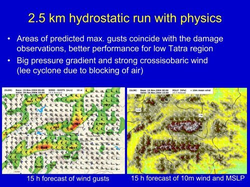
2.5 km hydrostatic run with physics• Areas of predicted max. gusts coincide with the damageobservations, better performance for low Tatra region• Big pressure gradient and strong crossisobaric wind(lee cyclone due to blocking of air)15 h forecast of wind gusts 15 h forecast of 10m wind and MSLP
- Page 1 and 2: Downslope windstorm in High Tatras1
- Page 3 and 4: Impact of the 19 November windstorm
- Page 5 and 6: Local observations• Gusty charact
- Page 7: Success of the operational forecast
- Page 11 and 12: 2,5 km non- hydrostatic run• Time
- Page 13 and 14: Sensitivity testsMax. gust 40 m/s33
- Page 15 and 16: Mesoscale diagnostics• Increase o
- Page 17 and 18: Conclusions: points of view• NWP
2.5 km hydrostatic run with physics• Areas of predicted max. gusts co<strong>in</strong>cide with the damageobservations, better performance for low Tatra region• Big pressure gradient and strong crossisobaric w<strong>in</strong>d(lee cyclone due to block<strong>in</strong>g of air)15 h forecast of w<strong>in</strong>d gusts 15 h forecast of 10m w<strong>in</strong>d and MSLP


