Coastal flood risk management strategy, Pegwell Bay to Kingsdown
Coastal flood risk management strategy, Pegwell Bay to Kingsdown
Coastal flood risk management strategy, Pegwell Bay to Kingsdown
- No tags were found...

You also want an ePaper? Increase the reach of your titles
YUMPU automatically turns print PDFs into web optimized ePapers that Google loves.
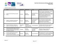
strategic options for managingthe <strong>strategy</strong> areaThe coastal and river frontageswithin the <strong>strategy</strong> area havebeen divided in<strong>to</strong> nine reachesreflecting the varying nature ofthe frontage and the specificissues affecting each reach.Reach 1: Cliffs End <strong>to</strong>S<strong>to</strong>nar CutGenerally low lying coast andriver frontage sheltered fromwave energy by the extensiveinter-tidal mudflat area inSandwich <strong>Bay</strong>.Reach 2: Shell Ness <strong>to</strong>Sandwich <strong>Bay</strong> EstateSand dunes fronted by a widesandy foreshore, which narrows<strong>to</strong>wards the southern end ofthis section. Shingle depositsoverlay the sand beach alongthe northern half of this unit.Reach 3: Sandwich <strong>Bay</strong> EstateThis residential area is locatedimmediately behind a concretebased revetment (bank)and thenatural shingle beach.Reach 4: Sandwich <strong>Bay</strong> Estate<strong>to</strong> Deal CastleBetween Sandwich <strong>Bay</strong> Estateand Deal <strong>flood</strong> protection isprovided by a colliery shaleembankment. Along the Dealfrontage this is replaced by aseawall and timber groynes. Ashingle beach providesadditional protection along thewhole of this frontage.Reach 5: Deal Castle <strong>to</strong>Walmer CastleThis frontage is characterisedby its wide and openshingle beach.Reach 6: Walmer Castle,<strong>Kingsdown</strong> and Oldstairs <strong>Bay</strong>The wide shingle beach atWalmer gradually reduces insize <strong>to</strong>wards the south. Aconcrete seawall, timbergroynes and the shingle beachprotect <strong>Kingsdown</strong>. A groynedshingle beach and rockrevetment provide erosionprotection <strong>to</strong> the exposed areaof Oldstairs <strong>Bay</strong>.Reach 7: MoD Rifle RangeThe former Rifle Range at thefoot of cliffs is protected by aconcrete seawall.Reach 8: Sandwich andS<strong>to</strong>nar LoopRiver frontage mainly protectedby earth embankments, with<strong>flood</strong> walls through Sandwich.Reach 9: S<strong>to</strong>ur ValleyRiver frontage predominantlyprotected by earthembankments with <strong>flood</strong>plainson both banks.Strategic optionsThe <strong>strategy</strong> will set out how weneed <strong>to</strong> manage coastal andtidal <strong>flood</strong> and erosion <strong>risk</strong> forthe next 100 years. To do thiswe will consider for each of thenine reaches a range of optionsdescribed in the table below.<strong>Coastal</strong> <strong>strategy</strong>Do nothing – no furthermaintenance or repair workis undertakenDo minimum – emergencyrepairs undertaken asrequiredMaintain – maintaining theexisting defences in theircurrent formSustain – defences areraised and strengthened <strong>to</strong>sustain the current standardof protectionImprove – defences areimproved <strong>to</strong> increase thestandard of protectionManaged realignment –moving defences inland in acontrolled way <strong>to</strong> a moresustainable positionEnvironment Agency <strong>Pegwell</strong> <strong>Bay</strong> <strong>to</strong> <strong>Kingsdown</strong> coastal <strong>strategy</strong> 5