Coastal flood risk management strategy, Pegwell Bay to Kingsdown
Coastal flood risk management strategy, Pegwell Bay to Kingsdown
Coastal flood risk management strategy, Pegwell Bay to Kingsdown
- No tags were found...

You also want an ePaper? Increase the reach of your titles
YUMPU automatically turns print PDFs into web optimized ePapers that Google loves.
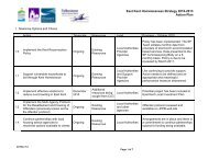
the <strong>Pegwell</strong> <strong>Bay</strong> <strong>to</strong><strong>Kingsdown</strong> coastlineThe frontage of the <strong>Pegwell</strong> <strong>Bay</strong><strong>to</strong> <strong>Kingsdown</strong> coastline has twodistinct characters. To thenorth of Sandwich <strong>Bay</strong> Estatethe coast is characterised by anextensive dune system behinda sand and shingle beach. Thedunes narrow <strong>to</strong>wards Dealwith low-lying agricultural landbehind. Most of the dunes areincorporated in<strong>to</strong> three golfcourses, which attract a largenumber of visi<strong>to</strong>rs <strong>to</strong> the area.The residential area of northDeal is also low-lying.To the south of Deal the landbegins <strong>to</strong> rise <strong>to</strong> meet the cliffsat the southern end of the<strong>strategy</strong> frontage. This stretch ischaracterised by residentialareas, with agricultural landfurther back. The shinglebeach is reinforced with formaldefences <strong>to</strong>wards the south.The area’s close proximity <strong>to</strong>the Continent has led <strong>to</strong> a richhis<strong>to</strong>ry in trade. Its his<strong>to</strong>ricbuildings and the Cinque Por<strong>to</strong>f Sandwich has resulted in thearea becoming a populardestination for visi<strong>to</strong>rs, withnumerous facilities andrecreational activities both landand water based.The River S<strong>to</strong>ur is tidal up <strong>to</strong>Fordwich, approximately 17miles upstream. With itstributaries it drains aconsiderable part of the Kentcountryside, flowing throughthe urban areas of Canterburyand Sandwich.The area supports large areasof coastal habitats designatedwithin the Natura 2000network. These include sitesdesignated as SpecialProtection Areas (SPA), SpecialAreas of Conservation (SAC),Sites of Special ScientificInterest (SSSI) and NationalNature Reserves (NNR).4 Environment Agency <strong>Pegwell</strong> <strong>Bay</strong> <strong>to</strong> <strong>Kingsdown</strong> coastal <strong>strategy</strong>