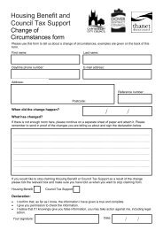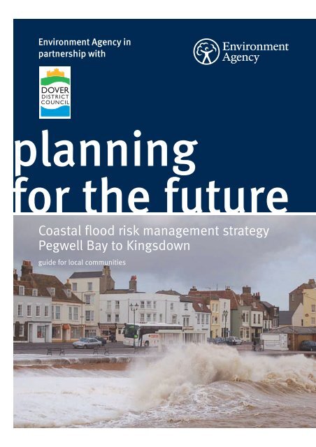
Coastal flood risk management strategy, Pegwell Bay to Kingsdown
Coastal flood risk management strategy, Pegwell Bay to Kingsdown
Coastal flood risk management strategy, Pegwell Bay to Kingsdown
- No tags were found...

Create successful ePaper yourself
Turn your PDF publications into a flip-book with our unique Google optimized e-Paper software.
Published by:Environment Agency in partnership withDover District CouncilEnvironment AgencyOrchard HouseEndeavour ParkLondon RoadAdding<strong>to</strong>nWest MallingKentME19 5SHwww.environment-agency.gov.uk/yourenv/consultations/current_consultations/© Environment Agency
introductionThe Environment Agency andDover District Council areworking <strong>to</strong>gether <strong>to</strong> develop a<strong>strategy</strong> <strong>to</strong> manage coastal<strong>flood</strong>ing and erosion between<strong>Pegwell</strong> <strong>Bay</strong> and the MoD RifleRange at Oldstairs <strong>Bay</strong>. The<strong>strategy</strong> will also look at tidal<strong>flood</strong>ing in the River S<strong>to</strong>urdownstream of Fordwich. Theresult will be the <strong>Pegwell</strong> <strong>Bay</strong> <strong>to</strong><strong>Kingsdown</strong> coastal <strong>strategy</strong>.This new <strong>strategy</strong> will developthe <strong>flood</strong> <strong>management</strong> policiesset out in the Isle of Grain <strong>to</strong>South Foreland shoreline<strong>management</strong> plan and theRiver S<strong>to</strong>ur catchment <strong>flood</strong><strong>management</strong> plan.With the climate changing, sealevels rising and increasedfrequency and intensity ofs<strong>to</strong>rms, our existing coastaldefences are under increasingthreat from the elements. Thisconsultation document sets outthe options for the <strong>strategy</strong> <strong>to</strong>manage the area’s coastal andtidal river defences over thenext 100 years.The Environment Agency andDover District Council havepowers <strong>to</strong> construct <strong>flood</strong>defences for the protection ofpeople and property wherethese are economically justifiedand government funds areavailable. The amount offunding available from centralgovernment is limited and thereis strong competition for thesefunds from around the country.The Environment Agency alsohas a legal obligation <strong>to</strong> protectendangered habitats such asinter-tidal salt marsh andmudflats that form part of anetwork of internationallydesignated sites. These areconsidered <strong>to</strong> be at <strong>risk</strong> fromrising sea levels and wheresections are lost compensa<strong>to</strong>ryareas will have <strong>to</strong> be provided.This document introduces thekey issues we need <strong>to</strong> addressin the <strong>strategy</strong> and outlines theleading options. It has beenprepared as part of the publicconsultation on the <strong>strategy</strong>and you are invited <strong>to</strong>comment. Details on how <strong>to</strong>contact us are provided on theinside back cover.Environment Agency <strong>Pegwell</strong> <strong>Bay</strong> <strong>to</strong> <strong>Kingsdown</strong> coastal <strong>strategy</strong> 3
the <strong>Pegwell</strong> <strong>Bay</strong> <strong>to</strong><strong>Kingsdown</strong> coastlineThe frontage of the <strong>Pegwell</strong> <strong>Bay</strong><strong>to</strong> <strong>Kingsdown</strong> coastline has twodistinct characters. To thenorth of Sandwich <strong>Bay</strong> Estatethe coast is characterised by anextensive dune system behinda sand and shingle beach. Thedunes narrow <strong>to</strong>wards Dealwith low-lying agricultural landbehind. Most of the dunes areincorporated in<strong>to</strong> three golfcourses, which attract a largenumber of visi<strong>to</strong>rs <strong>to</strong> the area.The residential area of northDeal is also low-lying.To the south of Deal the landbegins <strong>to</strong> rise <strong>to</strong> meet the cliffsat the southern end of the<strong>strategy</strong> frontage. This stretch ischaracterised by residentialareas, with agricultural landfurther back. The shinglebeach is reinforced with formaldefences <strong>to</strong>wards the south.The area’s close proximity <strong>to</strong>the Continent has led <strong>to</strong> a richhis<strong>to</strong>ry in trade. Its his<strong>to</strong>ricbuildings and the Cinque Por<strong>to</strong>f Sandwich has resulted in thearea becoming a populardestination for visi<strong>to</strong>rs, withnumerous facilities andrecreational activities both landand water based.The River S<strong>to</strong>ur is tidal up <strong>to</strong>Fordwich, approximately 17miles upstream. With itstributaries it drains aconsiderable part of the Kentcountryside, flowing throughthe urban areas of Canterburyand Sandwich.The area supports large areasof coastal habitats designatedwithin the Natura 2000network. These include sitesdesignated as SpecialProtection Areas (SPA), SpecialAreas of Conservation (SAC),Sites of Special ScientificInterest (SSSI) and NationalNature Reserves (NNR).4 Environment Agency <strong>Pegwell</strong> <strong>Bay</strong> <strong>to</strong> <strong>Kingsdown</strong> coastal <strong>strategy</strong>
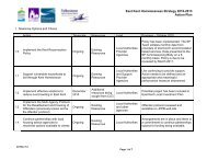
strategic options for managingthe <strong>strategy</strong> areaThe coastal and river frontageswithin the <strong>strategy</strong> area havebeen divided in<strong>to</strong> nine reachesreflecting the varying nature ofthe frontage and the specificissues affecting each reach.Reach 1: Cliffs End <strong>to</strong>S<strong>to</strong>nar CutGenerally low lying coast andriver frontage sheltered fromwave energy by the extensiveinter-tidal mudflat area inSandwich <strong>Bay</strong>.Reach 2: Shell Ness <strong>to</strong>Sandwich <strong>Bay</strong> EstateSand dunes fronted by a widesandy foreshore, which narrows<strong>to</strong>wards the southern end ofthis section. Shingle depositsoverlay the sand beach alongthe northern half of this unit.Reach 3: Sandwich <strong>Bay</strong> EstateThis residential area is locatedimmediately behind a concretebased revetment (bank)and thenatural shingle beach.Reach 4: Sandwich <strong>Bay</strong> Estate<strong>to</strong> Deal CastleBetween Sandwich <strong>Bay</strong> Estateand Deal <strong>flood</strong> protection isprovided by a colliery shaleembankment. Along the Dealfrontage this is replaced by aseawall and timber groynes. Ashingle beach providesadditional protection along thewhole of this frontage.Reach 5: Deal Castle <strong>to</strong>Walmer CastleThis frontage is characterisedby its wide and openshingle beach.Reach 6: Walmer Castle,<strong>Kingsdown</strong> and Oldstairs <strong>Bay</strong>The wide shingle beach atWalmer gradually reduces insize <strong>to</strong>wards the south. Aconcrete seawall, timbergroynes and the shingle beachprotect <strong>Kingsdown</strong>. A groynedshingle beach and rockrevetment provide erosionprotection <strong>to</strong> the exposed areaof Oldstairs <strong>Bay</strong>.Reach 7: MoD Rifle RangeThe former Rifle Range at thefoot of cliffs is protected by aconcrete seawall.Reach 8: Sandwich andS<strong>to</strong>nar LoopRiver frontage mainly protectedby earth embankments, with<strong>flood</strong> walls through Sandwich.Reach 9: S<strong>to</strong>ur ValleyRiver frontage predominantlyprotected by earthembankments with <strong>flood</strong>plainson both banks.Strategic optionsThe <strong>strategy</strong> will set out how weneed <strong>to</strong> manage coastal andtidal <strong>flood</strong> and erosion <strong>risk</strong> forthe next 100 years. To do thiswe will consider for each of thenine reaches a range of optionsdescribed in the table below.<strong>Coastal</strong> <strong>strategy</strong>Do nothing – no furthermaintenance or repair workis undertakenDo minimum – emergencyrepairs undertaken asrequiredMaintain – maintaining theexisting defences in theircurrent formSustain – defences areraised and strengthened <strong>to</strong>sustain the current standardof protectionImprove – defences areimproved <strong>to</strong> increase thestandard of protectionManaged realignment –moving defences inland in acontrolled way <strong>to</strong> a moresustainable positionEnvironment Agency <strong>Pegwell</strong> <strong>Bay</strong> <strong>to</strong> <strong>Kingsdown</strong> coastal <strong>strategy</strong> 5
what do these options mean for me?Nature can affect the coast and riverbanks in different ways. The level ofimpact depends on the current and future <strong>flood</strong>ing and erosion <strong>risk</strong>s in thedifferent reaches of the <strong>strategy</strong>. The condition of the existing <strong>flood</strong> defencesis also a fac<strong>to</strong>r in the impacts that can be expected as some are in bettercondition than others.The following identifies the impact on those reaches at <strong>risk</strong> of <strong>flood</strong>ing if noaction is taken. Reaches 2, 5, 7 and 9 require do nothing or do minimum asdescribed later.Reach 1: Cliffs End <strong>to</strong> S<strong>to</strong>nar CutIf nothing is done, 14 propertieswould be <strong>flood</strong>ed annually andtherefore lost by 2107. A further24 residential and commercialproperties would also beaffected by <strong>flood</strong>ing, althoughthe damage <strong>to</strong> individualproperties would vary.It is also likely <strong>to</strong> lead <strong>to</strong><strong>flood</strong>ing of large stretches ofthe low-lying land of theWantsum Channel, while <strong>flood</strong>damage <strong>to</strong> the A256 is alsoincreasingly likely.Reach 3: Sandwich <strong>Bay</strong> EstateAlthough the current defencesprovide sufficient protection <strong>to</strong>the properties in Sandwich <strong>Bay</strong>Estate now, if nothing is doneduring the next 100 years 38properties will be lost due <strong>to</strong>annual <strong>flood</strong>ing by 2107. Afurther 54 properties would beaffected by <strong>flood</strong>ing.Reach 4: Sandwich <strong>Bay</strong> Estate<strong>to</strong> Deal CastleAlmost 1,300 residential andcommercial properties arecurrently at <strong>risk</strong> of <strong>flood</strong>ingduring an extreme tidal event(1 in 100 chance of occurringeach year). This would rise <strong>to</strong>more than 4,000 by 2107 if noaction was taken, with many ofthose lost permanently.Along this reach the CinquePorts golf course is also likely <strong>to</strong>suffer significant damage, whilethe promenade and Pier at Dealwould also become increasinglyvulnerable <strong>to</strong> <strong>flood</strong> damage.Reach 6: Walmer, <strong>Kingsdown</strong>and Oldstairs <strong>Bay</strong>In this reach the main problemis erosion of the coastline,which will move landward if nomeasures are taken <strong>to</strong> s<strong>to</strong>p thisprocess. There would be asteady loss of property in thisreach and it is expected thatapproximately 177 propertieswould be lost by 2107.Reach 8: Sandwich and S<strong>to</strong>narLoopIn the current situation some<strong>flood</strong>ing already occursoccasionally, most markedly atSandwich Quay. To date, thishas not resulted in the loss ofproperties but there has beensome <strong>flood</strong> damage <strong>to</strong> propertyin Sandwich in the past – mostnotably in 1953 and 1983.Almost 500 properties arecurrently at <strong>risk</strong> of <strong>flood</strong>ingduring a tidal event with a 1 in 20chance of occurring each year.If no action was taken, by 2107some 1,400 properties would beaffected by <strong>flood</strong>ing <strong>to</strong> varyingdegrees during significant tidalevents, with nearly 600properties affected so badlythat they would be lost.6 Environment Agency <strong>Pegwell</strong> <strong>Bay</strong> <strong>to</strong> <strong>Kingsdown</strong> coastal <strong>strategy</strong>
shortlisted optionsFor each of the nine reaches a number of appropriate options were shortlistedfor further analysis. To determine the preferred option each of thereaches has been considered in terms of:• <strong>flood</strong> and erosion <strong>risk</strong> <strong>to</strong> people and property;• climate change and predicted sea level rise;• cost of the option and value of protected assets;• impact on the natural environment.The following paragraphs outline the characteristicsof all nine reaches <strong>to</strong>gether with the short-listedoptions for the relevant reach. The leading optionfor each reach has been highlighted in blue.<strong>Pegwell</strong> <strong>Bay</strong>, Reach 1Reach 1: Cliffs End <strong>to</strong> S<strong>to</strong>nar CutThe only reach combiningcoastal and river frontages,the reach between Cliffs Endand the S<strong>to</strong>nar Cut comprisesthe left bank of the RiverS<strong>to</strong>ur downstream of theS<strong>to</strong>nar Cut and the coastalfrontage of <strong>Pegwell</strong> <strong>Bay</strong>.<strong>Pegwell</strong> <strong>Bay</strong> Country Park hasa small embankment at itsperimeter boundary while theA256 provides furtherprotection <strong>to</strong> the land behind.There are no formal <strong>flood</strong>defence structures along theriver frontage as the groundlevel north of RichboroughPort provides the protectionagainst <strong>flood</strong>ing, while atRichborough Port itself, <strong>flood</strong>protection is provided by theland behind the quayside.The inter-tidal mudflats onthe coast and the rivercorridor itself are ofinternational environmentalvalue.The S<strong>to</strong>nelees Golf Club islocated behind the A256.Strategic optionDo nothingDo minimumSustainImproveActionsNo further work will be undertaken on the existing defencesRepair A256 road and rock revetment as and when damage occursThe existing defences currently offer sufficient protection. To sustain thisprotection in<strong>to</strong> the future the defences will need <strong>to</strong> be improved in about 50years, with a combination of walls and embankments adjacent <strong>to</strong> the A256Works are undertaken now <strong>to</strong> increase protection, with a combination of wallsand embankments adjacent <strong>to</strong> the A256Sustain has been selected because the existing level of protection is sufficient, although workswill be required in the future <strong>to</strong> allow for sea level rise. This option provides the best economicoption and will not have significant impact on the natural environment.Environment Agency <strong>Pegwell</strong> <strong>Bay</strong> <strong>to</strong> <strong>Kingsdown</strong> coastal <strong>strategy</strong> 7
Reach 2: Shell Ness <strong>to</strong> Sandwich <strong>Bay</strong> EstateThis reach comprises thecoastline between Shell Nessand Sandwich <strong>Bay</strong> Estate. It ischaracterised by a sandybeach backed by an extensivedune system. The groundlevels of the dune systemprovide protection from<strong>flood</strong>ing for the land behindthe dunes. The frontage has alarge area of inter-tidalmudflats on the seawardside, which narrows <strong>to</strong>wardsthe southern end of the reach.The entire frontage forms par<strong>to</strong>f an important internationalnature conservation area andthere is an RSPB naturereserve approximatelyhalfway along the reach. Thearea contains no residentialsettlements, but there are twomajor golf courses. Two longdistancefootpaths run alongthe length of the reachproviding access <strong>to</strong> the frontagefrom the centre of Sandwich.Strategic optionDo nothingDo minimumActionsNo further work will be undertaken on the existing defencesReactive maintenance onlyDo nothing has been selected because of the existing high level of protection provided by thebeach and works <strong>to</strong> the dunes would have a negative impact on the designated sites. In the even<strong>to</strong>f a major breach in the dune system during an extreme s<strong>to</strong>rm there is a possibility of emergencyrepairs, including re-profiling of dunes and breach repairs. Under the ‘do nothing’ option the <strong>risk</strong>of <strong>flood</strong>ing is acceptably low.Reach 3: Sandwich <strong>Bay</strong> EstateThe reach comprises ashingle beach backed by aconcrete revetment.The beach and defences inthis reach protect Sandwich<strong>Bay</strong> Estate, a residentialsettlement. To the southernend of the reach there is asailing club, which launchesits vessels directly fromthe beach.The land immediately <strong>to</strong> thenorth and south of Sandwich<strong>Bay</strong> Estate is subject <strong>to</strong>international environmentaldesignations, as are thebeach and foreshore.Strategic optionDo nothingDo minimumMaintainSustainActionsNo further work will be undertaken on the existing defencesExisting revetment is patch repaired when damage occursNo work on defences other than local maintenance in first 50 years.Replacement of the existing revetment in 2057No work on defences in first 50 years. Replacement of the existing revetmentin 2057 and beach nourishment undertaken <strong>to</strong> sustain the level of protectionMaintain has been selected because the existing level of protection is sufficient, but works will berequired in the future <strong>to</strong> ensure the integrity of the existing revetment. This option provides the besteconomic option and will not have significant impacts on the natural environment.8 Environment Agency <strong>Pegwell</strong> <strong>Bay</strong> <strong>to</strong> <strong>Kingsdown</strong> coastal <strong>strategy</strong>
Reach 4: Sandwich <strong>Bay</strong> Estate <strong>to</strong>Deal CastleNorth of Sandown Castle thefrontage consists of beachesbacked by a colliery shaleembankment and a narrowdune system. The beach anddunes are of importantinternational environmentalvalue. Further inland parts ofthe Lydden Valley are alsosubject <strong>to</strong> internationalenvironmental designations.A golf course is situatedamong the dunes and a longdistancefootpath follows thecoastline. The Lydden Valleycontains a dense network ofstreams and ditches and iscrossed by a mainline railway.From Sandown Castle <strong>to</strong> DealCastle the coast is protectedby a shingle beach withtimber groynes and aconcrete sea wall. The <strong>flood</strong>defences protect a large areaof Deal from <strong>flood</strong>ing.<strong>Coastal</strong> frontage north of Deal, Reach 4Both Deal and SandownCastles are scheduledmonuments, while the <strong>to</strong>wncontains several listedbuildings and conservationareas.Strategic optionDo nothingDo minimumMaintainImprove 1Improve 2Improve 3Improve 4ActionsNo further work will be undertaken on the existing defencesNo pro-active maintenance, but breaches or failures in the existing defenceswill be repaired if they occurThe existing defences will be actively maintained <strong>to</strong> reduce the <strong>risk</strong> ofbreaching or failure and keep them in a similar condition as they are <strong>to</strong>dayBeach <strong>management</strong> <strong>to</strong> increase the shingle volume of the beach throughout thereach. The existing timber groynes will remain in place until the end of theirremaining life. A rock revetment will be provided just north of Sandown Castle<strong>to</strong> protect the shale embankment. A low wave wall will be constructed in Deal<strong>to</strong> reduce the <strong>risk</strong> of waves over<strong>to</strong>pping on<strong>to</strong> the roadTimber groyne replacement and beach nourishment <strong>to</strong> increase the shinglevolume of the beach. Rock revetment will be provided just north of SandownCastle <strong>to</strong> protect the shale embankment. A wave wall will be constructed in DealRock groynes would replace the existing timber groynes with beachnourishment <strong>to</strong> increase the shingle volume of the beach. Rock revetment willbe provided just north of Sandown Castle <strong>to</strong> protect the shale embankment.A wave wall will be constructed in DealThree large rock headlands would replace the existing timber groynes withbeach nourishment <strong>to</strong> increase the shingle volume of the beach. Rockrevetment will be provided just north of Sandown Castle <strong>to</strong> protect the shaleembankment. A wave wall will be constructed in DealEnvironment Agency <strong>Pegwell</strong> <strong>Bay</strong> <strong>to</strong> <strong>Kingsdown</strong> coastal <strong>strategy</strong> 9
erosion <strong>risk</strong> andtidal <strong>flood</strong> <strong>risk</strong>10 Environment Agency <strong>Pegwell</strong> <strong>Bay</strong> <strong>to</strong> <strong>Kingsdown</strong> coastal <strong>strategy</strong>
Environment Agency <strong>Pegwell</strong> <strong>Bay</strong> <strong>to</strong> <strong>Kingsdown</strong> coastal <strong>strategy</strong> 11
Reach 4 ...continuedImprove 1 has been selectedbecause the existing level ofprotection just north ofSandown Castle is <strong>to</strong>o low,and north Deal would beexposed <strong>to</strong> <strong>flood</strong>ing if theembankment was damaged.In addition, a wave wall inDeal would mitigate againstfuture sea level rise, whichwould otherwise lead <strong>to</strong>increasing <strong>flood</strong> damage inDeal by waves over<strong>to</strong>ppingthe seawall. The beach<strong>management</strong> option wouldprovide a wider moreextensive shingle beach <strong>to</strong>protect Deal, and is theleading economic solution.Deal seafront, Reach 4Reach 5: Deal Castle <strong>to</strong> Walmer CastleThe frontage between DealCastle and Walmer Castleconsists of a shingle beachwith no formal <strong>flood</strong> defences.The beach widens from 50m inthe north <strong>to</strong> 100m <strong>to</strong>wards thesouthern end of the reach,providing sufficient <strong>flood</strong>defence for Walmer and thesouth of Deal. There are twoscheduled monuments locatedimmediately behind the beach,with Walmer Castle set in<strong>to</strong> ahis<strong>to</strong>ric park and garden.A long-distance footpath runsalong the entire length of thefrontage.Strategic optionDo nothingDo minimumActionsNo further work will be undertaken on the existing defencesNo active maintenance will be undertaken. However, some minor beach<strong>management</strong> work could be undertaken if these are beneficial <strong>to</strong> coastalprocesses for neighbouring frontagesDo minimum has been selected because the existing level of protection provided by the beach ishigh, and is expected <strong>to</strong> remain so with future sea level rise. No properties would be at <strong>risk</strong> if the ‘dominimum' option is adopted.12 Environment Agency <strong>Pegwell</strong> <strong>Bay</strong> <strong>to</strong> <strong>Kingsdown</strong> coastal <strong>strategy</strong>
Reach 6: Walmer Castle, <strong>Kingsdown</strong> and Oldstairs <strong>Bay</strong>This reach comprises thecoastal frontage betweenWalmer Castle and the MoDRifle Range. The frontageconsists of beaches with a seawall at <strong>Kingsdown</strong>,interspersed by timbergroynes.Behind the coastal defencesthe land rises relatively steeplyand consists predominantly oflow <strong>to</strong> medium densityresidential development, withagricultural land furtherinland.A long-distance footpath runsalong the northern frontagewithin the reach.Strategic optionDo nothingDo minimumMaintainSustainImproveActionsNo further work will be undertaken on the existing defencesNo pro-active maintenance, but breaches or failures in the existing defenceswill be repaired if they occurBeach recycling combined with replacement of existing timber groynes at the endof their remaining life (about 10 years). Supplemented by shingle when requiredSimilar <strong>to</strong> maintain option, but repairs <strong>to</strong> timber groynes will start early in the<strong>strategy</strong> and additional shingle will be brought on<strong>to</strong> the beachA range of improvement options have been considered, including constructionof rock headlands, replacement of existing groynes and beach with rockrevetment, construction of rock groynes and the refurbishment and upgrade ofthe existing seawall at <strong>Kingsdown</strong>Maintain has been selected since this option would prevent erosion and loss of property, and is themost cost-effective and environmentally acceptable solution.Reach 7: MoD Rifle RangeThe MoD Rifle Range consistsof an elevated plateau of fillmaterial in front of chalk cliffs,protected by a concreteseawall.The site and cliffs are subjectStrategic optionDo nothingDo minimumManagedrealignmentActions<strong>to</strong> national environmentaldesignations and a footpathruns along the base of the cliffs.There is some uncertaintyabout the nature of the fillmaterial for release in<strong>to</strong> theNo further work will be undertaken on the existing defencescoastal system. The sea wallhas collapsed at one sectionallowing some fill material <strong>to</strong>seep out.The site is owned by the MoD.Repair of failed sections of the seawall and reactive repairs <strong>to</strong> further failures.These repairs are likely <strong>to</strong> consist of steel sheet piled retaining walls or rockarmour infillFollowing a detailed investigation of fill material for contamination andappropriate remediation work, the existing seawall would be removed or left <strong>to</strong>collapse allowing the site <strong>to</strong> return <strong>to</strong> natural processesManaged realignment has been selected. This would provide the maximum environmental benefit,res<strong>to</strong>ring the coastline <strong>to</strong>wards a more natural process, which would benefit the beaches <strong>to</strong> thenorth. This option is dependent on further analysis of the site and the availability of funding andintentions of the land owner, who will be responsible for implementation of this option.Environment Agency <strong>Pegwell</strong> <strong>Bay</strong> <strong>to</strong> <strong>Kingsdown</strong> coastal <strong>strategy</strong> 13
Reach 8: Sandwich and S<strong>to</strong>nar LoopThe Sandwich and S<strong>to</strong>nar reachcomprises the downstreamsection of the tidal River S<strong>to</strong>uras it loops through the his<strong>to</strong>ric<strong>to</strong>wn of Sandwich.Industrial activity dominatesland inside the loop, withPfizer owning the majority.The area east of the river loopis predominantly high gradeagricultural land, with largesections subject <strong>to</strong>environmental designationssuch as SSSI, SAC, Ramsarsite and SPA.Sandwich is rich in culturalheritage, including scheduledmonuments, listed buildingsand conservation areas.Further upstream on the rightbank Richborough Castle isalso a scheduled monument.Long-distance footpaths arelocated along the banks ofthe river.The A256 crosses the RiverS<strong>to</strong>ur west of Sandwich andruns through the centre of theS<strong>to</strong>nar Loop <strong>to</strong> Thanet and theDeal <strong>to</strong> Canterbury railwayline runs through Sandwichand follows the westernsection of the river.Strategic optionDo nothingDo minimumSustainImprove 1Improve 2Improve 3ActionsNo further work will be undertaken on the existing defencesNo pro-active maintenance, but breaches or failures in the existing defenceswill be repaired if they occurTo continue the present standard of protection, the existing ‘on-line’ defences(such as the banks of the River S<strong>to</strong>ur) will be raised <strong>to</strong> allow for projected sealevel rises. They will need raising again in 50 years <strong>to</strong> keep pace with thecontinued sea level rises‘On-line’ defences – raising defences along the River S<strong>to</strong>ur <strong>to</strong> increase thestandard of protection. As under the ‘sustain’ option these defences will have<strong>to</strong> be raised again in 50 years <strong>to</strong> keep pace with sea level risesTidal s<strong>to</strong>rage and ‘on-line’ defences – Construction of a tidal s<strong>to</strong>rage facility inthe Broad Salts area. This includes the construction of a spillway,embankments and a drainage facility. The ‘on-line’ defences will also need <strong>to</strong>be raised, but not as much as if ‘on-line’ defences were the only protectionTidal barrier and ‘on-line’ defences – A tidal barrier would be constructed onthe River S<strong>to</strong>ur near Richborough Port. The existing embankments on theeastern bank of the River S<strong>to</strong>ur would be raised and strengthened andextended <strong>to</strong> the coast north of Sandwich <strong>Bay</strong> Estate. The ‘on-line’ defences willalso need <strong>to</strong> be raised, but not as much as for ‘on-line’ defences onlyAll improve options have been evaluated against economic andenvironmental criteria. Improve 2 has been selected becausethe existing level of protection is <strong>to</strong>o low, and significant areasof Sandwich and all of S<strong>to</strong>nar Loop are at <strong>risk</strong> of <strong>flood</strong>ing. Thetidal s<strong>to</strong>rage option keeps the raising of the ‘on-line’ defencesthrough Sandwich <strong>to</strong> a minimum. It also provides potential for a230 hectares wetland/nature reserve <strong>to</strong> be developed,enhancing the existing network of designated sites andproviding additional recreation opportunities. It is the leadingeconomic and environmental solution.Sandwich, Reach 814 Environment Agency <strong>Pegwell</strong> <strong>Bay</strong> <strong>to</strong> <strong>Kingsdown</strong> coastal <strong>strategy</strong>
Broad Salts, Reach 8Environment Agency <strong>Pegwell</strong> <strong>Bay</strong> <strong>to</strong> <strong>Kingsdown</strong> coastal <strong>strategy</strong> 15
Reach 9: S<strong>to</strong>ur ValleyAlong the River S<strong>to</strong>ur <strong>flood</strong>protection is predominantlyprovided by earthembankments, apart from thefrontage immediately north ofRichborough Castle whereground levels provideadequate protection againsttidal <strong>flood</strong>ing.The land on both banks isconsidered <strong>to</strong> be good <strong>to</strong> verygood grade agricultural land.Flooding in this reach isdominated by fluvial processes.Therefore the long-termstrategic <strong>management</strong> of thisarea will be determined in theforthcoming Lower S<strong>to</strong>ur River<strong>strategy</strong>. The option identifiedin this <strong>Pegwell</strong> <strong>Bay</strong> <strong>to</strong>Flooding 2001<strong>Kingsdown</strong> coastal <strong>strategy</strong> isa ‘holding’ option untilcompletion and adoption ofthe Lower S<strong>to</strong>ur River <strong>strategy</strong>.The preferred policy from theCatchment Flood ManagementPlan (CFMP) for this reach is<strong>to</strong> ‘Take action <strong>to</strong> increasefrequency of <strong>flood</strong>ing <strong>to</strong> bringbenefits elsewhere’.Strategic optionDo nothingDo minimumActionsNo further work will be undertaken on the existing defencesThe condition of the existing defences would be moni<strong>to</strong>red and any damagerepaired on a reactive basisDo minimum has been selected as a holding option until completion of the Lower S<strong>to</strong>ur River<strong>strategy</strong>. It is anticipated that managed realignment will be the preferred option in this reach <strong>to</strong>reduce <strong>flood</strong> <strong>risk</strong> <strong>to</strong> Canterbury. The viability and extent of this managed realignment will bedetermined by the Lower S<strong>to</strong>ur River Strategy.16 Environment Agency <strong>Pegwell</strong> <strong>Bay</strong> <strong>to</strong> <strong>Kingsdown</strong> coastal <strong>strategy</strong>
NotesEnvironment Agency <strong>Pegwell</strong> <strong>Bay</strong> <strong>to</strong> <strong>Kingsdown</strong> coastal <strong>strategy</strong> 17
Notes18 Environment Agency <strong>Pegwell</strong> <strong>Bay</strong> <strong>to</strong> <strong>Kingsdown</strong> coastal <strong>strategy</strong>
Have your sayThis document is a summary of the options developed in partnership with Dover District Council andin line with government guidelines.We want <strong>to</strong> know what you think. Your opinions on the leading options are important:• Do you support the leading options?• Do you have ideas for improvements?• Do you have any other comments?Please send us your comments before 12th Oc<strong>to</strong>ber 2007 <strong>to</strong> either of the following addresses.Please mark your envelope <strong>Pegwell</strong> <strong>Bay</strong> <strong>to</strong> <strong>Kingsdown</strong> <strong>Coastal</strong> Strategy.Environment AgencyOrchard HouseEndeavour ParkLondon RoadAdding<strong>to</strong>nWest MallingKent, ME19 5SHor email: pbk@environment-agency.gov.ukDover District CouncilWhite Cliff Business ParkDoverKentCT16 3PJFor additional copies please call 08708 506 506 (Mon - Fri 8-6). Or visit our websitewww.environment-agency.gov.uk/yourenv/consulation/current_consultations/What happens next?We will be holding public exhibitions in Sandwich and Deal.Dates and times will be advertised in advance in the local press.We will incorporate any comments that we receive in<strong>to</strong> the <strong>strategy</strong> report. This will define theconstruction, improvement or maintenance works that are required in the next five years between<strong>Pegwell</strong> <strong>Bay</strong> and <strong>Kingsdown</strong>, including up the River S<strong>to</strong>ur through Sandwich. The <strong>strategy</strong> report willalso define an overall <strong>flood</strong> <strong>risk</strong> <strong>management</strong> plan for the next 100 years.The <strong>strategy</strong> will then be issued <strong>to</strong> the Department for Environment Food and Rural Affairs (Defra) forreview and approval.Environment Agency <strong>Pegwell</strong> <strong>Bay</strong> <strong>to</strong> <strong>Kingsdown</strong> coastal <strong>strategy</strong> 19
Would you like <strong>to</strong> find out more about us,or about your environment?Then call us on08708 506 506 (Mon-Fri 8-6)emailenquiries@environment-agency.gov.ukor visit our websitewww.environment-agency.gov.ukincident hotline 0800 80 70 60 (24hrs)<strong>flood</strong>line 0845 988 1188Environment first: This publication is printed on paper madefrom 100 per cent previously used waste. By-products frommaking the pulp and paper are used for composting and fertiliser, formaking cement and for generating energy.GESO0707BMZU-E-P