Pelham Road/The Avenue - Gravesham Borough Council
Pelham Road/The Avenue - Gravesham Borough Council
Pelham Road/The Avenue - Gravesham Borough Council

You also want an ePaper? Increase the reach of your titles
YUMPU automatically turns print PDFs into web optimized ePapers that Google loves.
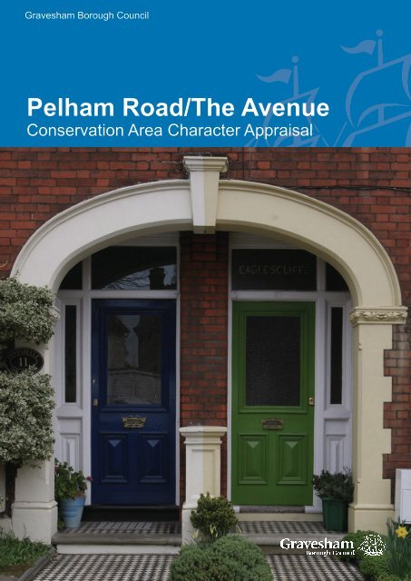
<strong>Gravesham</strong> <strong>Borough</strong> <strong>Council</strong><strong>Pelham</strong> <strong>Road</strong>/<strong>The</strong> <strong>Avenue</strong>Conservation Area Character Appraisal
Cover: <strong>The</strong> <strong>Avenue</strong>, <strong>Pelham</strong> <strong>Road</strong>/<strong>The</strong> <strong>Avenue</strong> Conservation Area, Northfleet
<strong>Pelham</strong> <strong>Road</strong>/<strong>The</strong> <strong>Avenue</strong> Conservation Area Appraisal 2009<strong>Pelham</strong> <strong>Road</strong>/<strong>The</strong> <strong>Avenue</strong>Conservation AreaCharacter AppraisalThis document was prepared on behalf of <strong>Gravesham</strong> <strong>Borough</strong> <strong>Council</strong> based on an extensivesurvey dated 2007 by:<strong>The</strong> Conservation Studio1 Querns LaneCirencesterGloucestershireGL7 1RLTel: 01285 642428Email: info@theconservationstudio.co.ukwww.theconservationstudio.co.ukPublished by <strong>Gravesham</strong> <strong>Borough</strong> <strong>Council</strong> 2009
<strong>Pelham</strong> <strong>Road</strong>/<strong>The</strong> <strong>Avenue</strong> Conservation Area 2009CONTENTS1 Statement of Special Interest of the Conservation Area 12 <strong>Pelham</strong> <strong>Road</strong>/ <strong>The</strong> <strong>Avenue</strong> Conservation Area 22.1 Background2.2 Purpose of the appraisal2.3 Planning policy context2.4 Community Involvement3 Location and Landscape Setting 53.1 Geographic location3.2 Activities and uses3.3 Topography3.4 Geology and Biodiversity3.5 Relationship of the Conservation Area to its surroundings4 Historical Development 74.1 Archaeology4.2 Historical development5 Spatial Analysis 115.1 Layout and spaces5.2 Relationship of buildings to spaces5.3 Landmarks, focal points and views5.4 Trees, boundaries and planting6 Streetscape 146.1 Public Realm7 <strong>The</strong> buildings of the conservation area 167.1 Building types7.2 Building form7.3 Listed buildings7.4 Locally listed buildings7.5 Key unlisted buildings7.6 Building Materials7.7 Local Details
<strong>Pelham</strong> <strong>Road</strong>/<strong>The</strong> <strong>Avenue</strong> Conservation Area 20098 Character Areas 198.1 Summary of Character Areas8.2 Character Area 1: <strong>Pelham</strong> <strong>Road</strong>8.3 Character Area 2: Bycliffe Terrace and <strong>Pelham</strong> Terrace8.4 Character Area 3: <strong>The</strong> <strong>Avenue</strong> and Lennox <strong>Road</strong> East9 Issues 259.1 Definition of issues9.2 Conservation area boundary review9.3 Education and information9.4 Uses/ vitality9.5 Enhancement potential9.6 Highways and traffic management9.7 Locally Listed buildings9.8 Trees and Landscape9.9 Archaeological PotentialAppendices 28Appendix 1Appendix 2BibliographyTownscape Appraisal MapAge of Buildings MapDesignations MapConservation Area Boundary Map 2009
<strong>Pelham</strong> <strong>Road</strong>/<strong>The</strong> <strong>Avenue</strong> Conservation Area Appraisal 200922. PELHAM ROAD/THE AVENUECONSERVATION AREA2.1 Background<strong>The</strong> <strong>Pelham</strong> <strong>Road</strong>/<strong>The</strong> <strong>Avenue</strong> ConservationArea was designated on 15 th February1995 by <strong>Gravesham</strong> <strong>Borough</strong> <strong>Council</strong> andwas extended on 14 th February 2001. <strong>The</strong>Conservation Area’s boundary includes thecentral part of <strong>Pelham</strong> <strong>Road</strong>, which is one ofthe connecting roads between Gravesendtown centre and the Old Dover <strong>Road</strong>. <strong>The</strong>adjacent roads of Bycliffe Terrace, <strong>Pelham</strong>Terrace, to the west, and <strong>The</strong> <strong>Avenue</strong> andLennox <strong>Road</strong> East to the east, are alsoincluded in the designation. <strong>The</strong> ConservationArea is part of the extensive 19 th centuryresidential suburbs to the south of Gravesendand is located close to the site of the Saxonsettlement of <strong>Gravesham</strong> and a former parishchurch.2.2 Purpose of the appraisalThis conservation area appraisal has beenwritten by <strong>The</strong> Conservation Studio on behalfof <strong>Gravesham</strong> <strong>Borough</strong> <strong>Council</strong>. It wasprepared in January 2008 and was followedby a process of community engagement,which informed the content of this document.This appraisal defines the special architecturaland historic interest for which <strong>Pelham</strong> <strong>Road</strong>/<strong>The</strong> <strong>Avenue</strong> Conservation Area meritsdesignation. It identifies the positive featuresthat should be protected and highlights thenegative factors that detract from its characterand appearance. It will be used by the<strong>Borough</strong> <strong>Council</strong> in considering proposalsfor demolition or alteration of buildings, aswell as for new developments. It will alsohelp property owners and developers totake account of the importance of buildings,features, spaces and landscape within andadjacent to the Conservation Area.This conservation area character appraisaland that of the two other 19 th centurysuburban Conservation Areas in Gravesend,i.e. Darnley <strong>Road</strong> and Windmill Hill, will leadto a management plan, setting out policiesand actions to conserve and enhance thespecial architectural and historic interest ofthe two conservation areas and to mitigate theeffects of negative features. <strong>The</strong> appraisalsand management plans are to be includedas background papers in the emerging LocalDevelopment Framework (LDF) and, as such,will be a due consideration in the planningprocess. In due course the appraisals andmanagement plans may also be adopted as aseparate Development Plan Document withinthe LDF.Preparation of the appraisal involved anextensive survey of the conservation areaundertaken in October 2007. <strong>The</strong> omission ofany particular feature does not imply that it isof no significance.2.3 Planning policy contextConservation Areas are defined as ‘areas ofarchitectural or historic interest the characteror appearance of which it is desirable topreserve or enhance’ in the Planning (ListedBuildings and Conservation Areas) Act1990 (<strong>The</strong> Act). Local Planning Authoritiesare required by the Act to identify the partsof their area that should be designated asconservation areas and to formulate andpublish proposals to preserve or enhancethem. Local authorities must submitproposals for the protection and enhancementof conservation areas for consideration at apublic meeting within the relevant area. <strong>The</strong>ymust also have regard to any views expressedby people attending the meeting.
<strong>Pelham</strong> <strong>Road</strong>/<strong>The</strong> <strong>Avenue</strong> Conservation Area Appraisal 2009new connection at nearby Ebbsfleet, nowcompleted) and several major road buildingschemes such as the widening of the A2 tothe south of the town.<strong>The</strong> policies included in the local and regionalguidance, as outlined above, seek to guidethis period of change and the specifiedpolicies all recognise the importance ofretaining <strong>Gravesham</strong>’s heritage. <strong>The</strong>management plan that accompanies thisdocument will propose how <strong>Gravesham</strong>’sspecial character can be preserved andenhanced while these large scale changestake place.documents were drafted. Subsequently, aperiod of full public consultation was heldafter which further revisions were madeto arrive at this final agreed document. APublic Consultation Report is attached to thisdocument as Appendix 3 for information.2.4 Community involvement<strong>The</strong> survey of the Conservation Area hasincluded a process of public consultation toidentify the following:• <strong>The</strong> special characteristics of the <strong>Pelham</strong><strong>Road</strong>/<strong>The</strong> <strong>Avenue</strong> Conservation Area;• <strong>The</strong> key negative features and issues;• A range of possible actions that wouldmitigate or offset these detractors.<strong>The</strong> consultation began with the notificationof key stakeholders in Gravesend at thebeginning of the appraisal process. It wasfollowed by the distribution to every propertyin the conservation areas of an invitation to apublic meeting held on 29 th November 2007.Leaflets were also displayed in public places.<strong>The</strong> meeting included a description of theprincipal and desired outcomes of appraisalsand management plans and led into a generaldiscussion. <strong>The</strong> meeting was attendedby various representatives of the <strong>Borough</strong><strong>Council</strong> and local interest groups.4Following the meeting, the outcomes werediscussed by <strong>Gravesham</strong> <strong>Borough</strong> <strong>Council</strong>and <strong>The</strong> Conservation Studio, and the
<strong>Pelham</strong> <strong>Road</strong>/<strong>The</strong> <strong>Avenue</strong> Conservation Area Appraisal 20093. LOCATION AND LANDSCAPESETTING3.1 LocationGravesend is the administrative capital of the<strong>Borough</strong> of <strong>Gravesham</strong> in north-west Kent.<strong>The</strong> <strong>Borough</strong> is generally rural in appearancewith a number of attractive historic villages,Northfleet and Gravesend forming the onlyurban areas in the locality.Gravesend is about 35 kilometres to theeast of central London, with Canterburyapproximately 65 kilometres to the south andeast. <strong>The</strong> A2 and M2 trunk roads link theselocations, and because of the proximity of theM25 and M20 motorways, and the rail link tothe Channel Tunnel, Gravesend is very wellconnected to other parts of the country andbeyond.<strong>The</strong> Oxford Archaeological Unit’s KentHistoric Landscape Characterisation (2001),commissioned by Kent County <strong>Council</strong> andEnglish Heritage, notes that: “<strong>The</strong> processof 19 th and 20 th century urbanisation isparticularly marked in the northern areas ofKent”. Within this study, the Dartford and<strong>Gravesham</strong> Conurbation is characterised as“a well defined urban conurbation with somelimited marshland and horticulture along itsedges”.<strong>The</strong> <strong>Pelham</strong> <strong>Road</strong>/<strong>The</strong> <strong>Avenue</strong> ConservationArea is approximately half a mile to the southwest of Gravesend town centre and includesthe 19 th century residential houses in <strong>Pelham</strong><strong>Road</strong>, Lennox <strong>Road</strong> East and <strong>The</strong> <strong>Avenue</strong> aswell as some later infill development.3.2 Activities and usespredominantly in residential use. Lennox<strong>Road</strong> East, <strong>The</strong> <strong>Avenue</strong>, Bycliffe Terrace and<strong>Pelham</strong> Terrace retain a strong residentialcharacter, whereas some of the largerproperties on <strong>Pelham</strong> <strong>Road</strong> have beenconverted. New uses introduced into thesebuildings include a doctor’s surgery in whatwas formerly Kent County <strong>Council</strong> offices,an education centre, a driving test centre,a nursery school and several residentialcare homes. Gravesend Grammar Schoolfor Girls lies immediately to the south of theConservation Area boundary, the schoolgenerating an intense amount of pedestrianand vehicle traffic in the surrounding roads atparticular times in the day.Whilst there is a reasonable amount ofpedestrian movement around the streets ofthe Conservation Area in the daytime, mostof the activity is related to the car, van andlorry traffic on <strong>Pelham</strong> <strong>Road</strong>, which is usuallypassing through the area. <strong>The</strong> <strong>Avenue</strong> isgenerally relatively quiet.3.3 TopographyThis part of Gravesend has a leveltopography, and a flat landscape thereforecharacterises both <strong>Pelham</strong> <strong>Road</strong> and <strong>The</strong><strong>Avenue</strong>. To the north of the ConservationArea, the land eventually descends to theriver Thames, and to the south-east it rises upto the peak of Windmill Hill. To the south, theground level falls away slightly from the WhitePost Public House, and descends gradually tothe junction with Old <strong>Road</strong>.<strong>The</strong> main routes within the Conservation Areaare generally very straight and wide, althoughthe connecting road of Lennox <strong>Road</strong> East hasa noticeable kink towards its west end.5<strong>The</strong> buildings in the Conservation Area are
<strong>Pelham</strong> <strong>Road</strong>/<strong>The</strong> <strong>Avenue</strong> Conservation Area Appraisal 20093.4 Geology and BiodiversityGravesend lies on a thick belt of chalk that isthe most significant geological trademark ofthis part of Kent. Otherwise, the geology ofKent is varied and lies on a “crumpled dome”of sedimentary rock which also lies underSussex and Surrey. <strong>The</strong> dome’s peak haseroded, exposing the rocks below, while thechalk along the edge has been more resilientto erosion and has created the North Downsin Kent and the South Downs in Sussex <strong>The</strong>area between the two is the Weald, notablefor its heavy clays and sandstone outcrops.<strong>The</strong> abundant availability of chalk inGravesend and Northfleet has had aconsiderable effect on the area as it hasbeen excavated for many centuries andused for various activities associated withthe construction of buildings. While chalkitself is too soft to be used for building largestructures, it supplied the raw materials forlime and, later, for cement. Other naturaldeposits, such as flint, have been utilised inconstruction, notably in the Conservation Areafor the cottages and boundary walls in BycliffeTerrace.and mainly rows of 19 th century terracedhousing and shops along Old <strong>Road</strong> andDover <strong>Road</strong>, with occasional churchesand other community buildings;• To the west: Further residential roads, adisused chalk pit and the mainline railwaytracks;• To the north: More spaciously arrangedbuildings, including ‘Mayfield’ (nowBronte School), built in 1875 and one ofthe earliest concrete houses. <strong>The</strong> areaalso includes Increasingly commercialpremises such as a modern car showroomat the junction of Darnley <strong>Road</strong>, where thehighway leads across the railway tracksinto the Transport Quarter of Gravesendtown centre. Most of the area to the northand east is included in the Darnley <strong>Road</strong>Conservation Area;th• To the east: 19 and 20 th centuryresidential buildings lining the roads, andthe open space of the Bat and Ball CricketGround leading to the slopes of WindmillHill.<strong>The</strong> settlement lies close to good sourcesof sand and these, which together withthe London Clay found on the nearby HooPeninsula to the east, provided the rawmaterials for brick making.3.5 Relationship of the Conservation Area toits surroundings<strong>The</strong> immediate surroundings of theConservation Area are suburban townscape.<strong>The</strong> following features form the immediatesetting of the Conservation Area:6• To the south: <strong>The</strong> grounds of theGravesend Grammar School for Girls
<strong>Pelham</strong> <strong>Road</strong>/<strong>The</strong> <strong>Avenue</strong> Conservation Area Appraisal 200974. HISTORICAL DEVELOPMENT4.1 ArchaeologyEvidence of prehistoric activity in and aroundGravesend and Northfleet is rich. Many findsfrom the lower Palaeolithic period havingbeen made in the Ebbsfleet valley includingthe richest Levallois site in Britain (containingdistinctive knapped flints), and there havebeen prehistoric finds of flint axes andpottery sherds. <strong>The</strong> remains of a substantialRoman villa complex has been discovered inNorthfleet and a Roman road found close tothe river in Gravesend. <strong>The</strong> most importantand extensive local excavation in recentyears, at nearby Springhead on the pathof the new Channel Tunnel Rail Link, hasuncovered the Roman town of Vagniacae, aformer Iron Age settlement that the Romansoccupied in 43 AD. A hoard of 552 Saxoncoins and a silver cross were found in 1838 tothe south of the Conservation Area.Archaeological evidence points to theexistence of a Saxon settlement a shortdistance to the south of the ConservationArea, and Bycliffe Terrace is the site of theformer Parish Church of St Mary. <strong>The</strong> areaincluding Bycliffe Terrace and the southernpart of <strong>Pelham</strong> <strong>Road</strong> is within one of KentCounty <strong>Council</strong>’s designated Areas ofArchaeological Potential.4.2 Historical development<strong>Pelham</strong> <strong>Road</strong> and the surrounding areadeveloped as part of the suburban expansionof Gravesend. Earlier phases of suburbandevelopment had occurred on land to theeast in the early 19 th century, such as alongDarnley <strong>Road</strong>, but the development of <strong>Pelham</strong><strong>Road</strong> did not occur until the end of the 19 thcentury. <strong>The</strong> road was originally a meanderinglane traversing open countryside andconnecting through to the Dover to Londonstagecoach route which ran along Old <strong>Road</strong>.This was maintained by the Turnpike Trusteesfrom 1711-1801, when the New <strong>Road</strong> wasopened and the milestones were moved there.<strong>Pelham</strong> <strong>Road</strong> was not named as such untilthe mid 19 th century. It was earlier calledManor <strong>Road</strong> (as on the First Edition OrdnanceSurvey map of 1870), after Gravesend ManorFarm which lay at the junction of <strong>Pelham</strong><strong>Road</strong> and Darnley <strong>Road</strong>. Sometimes it wascalled Style’s Lane after the farmer, and alsoWhite Post Lane after the white posts whichsurrounded the glebe lands in this part of thesettlement. <strong>The</strong> <strong>Pelham</strong> <strong>Road</strong>/ <strong>The</strong> <strong>Avenue</strong>Conservation Area forms part of the southwesternsuburbs of Gravesend; the historicaldevelopment has been covered in detail ina variety of publications, details of which areincluded in the bibliography at the end of thisdocument.<strong>The</strong> name “Gravesend” is derived from<strong>Gravesham</strong>, itself meaning “graaf-ham”, thehome of the reeve or bailiff of the Lord of theManor. <strong>The</strong> earliest written recording of thesettlement is a reference to <strong>Gravesham</strong> in<strong>The</strong> Domesday Book of 1086, which attributesownership of this agricultural estate to Odo,Bishop of Bayeux (the brother of William I). Itnoted that the Manor had been split under theownership of three Saxon thanes (or lords)before 1066. <strong>The</strong> Saxon settlement had grownaround the Old Dover <strong>Road</strong> where the ParishChurch of St Mary was built. It is thought thatthis Parish Church lay to the rear of the WhitePost Public House, as this was the site of anumber of churches until the 16 th century. <strong>The</strong>settlement surrounding the church remainedrural through the centuries. With the grantingof the first market charter in 1356, a marketwas located on the corner of High Street and
<strong>Pelham</strong> <strong>Road</strong>/<strong>The</strong> <strong>Avenue</strong> Conservation Area Appraisal 2009West Street, providing a new focus for thetown closer to the river and away from theParish Church inland. This development ledto the redundancy of the church and insteada chapel was built behind High Street in 1544;the chapel was located on the present daysite of the Parish Church of St George. StMary’s fell into ruin during the 16 th century andin 1797 the ruins and the churchyard wallswere removed by a tenant of Manor Farm.<strong>The</strong> land to either side of <strong>Pelham</strong> <strong>Road</strong>remained undeveloped until the second halfof the 19 th century. <strong>The</strong> first buildings to beerected were the White Post Public Houseand the cottages to the rear (White PostTerrace, now <strong>Pelham</strong> Terace), which werebuilt in 1844 following the sale of the land ofthe site of the former parish church, St Mary’s.<strong>The</strong> White Post became fully licensed in 1846,when an extensive fire in the High Streetnecessitated the removal of the licensee fromthe Black Horse. This group of buildings areclearly visible on the First Edition OrdnanceSurvey map of 1870, with only open fieldssurrounding them.<strong>The</strong> majority of the buildings within theConservation Area were constructed assingle family dwellings, however a number ofthe largest buildings on <strong>Pelham</strong> <strong>Road</strong> havesubsequently been subdivided. It is likely thatthis subdivision began to occur in the early20 th century, as there were fewer domesticstaff available to serve such large premises.Within the Conservation Area there are also anumber of small houses which were erectedpost-war, as infill on plots not previouslydeveloped, or on which properties had beenbomb damaged.<strong>The</strong> next phase of development occurredalong the western side of <strong>Pelham</strong> <strong>Road</strong> in the1870s. A number of large houses and BycliffeTerrace had been constructed by the 1897edition of the Ordnance Survey map. <strong>The</strong>last roads within the Conservation Area tobe laid out were Lennox <strong>Road</strong> East and <strong>The</strong><strong>Avenue</strong>. <strong>The</strong>se two roads are visible on the1907 Ordnance Survey map, which showsthat <strong>The</strong> <strong>Avenue</strong> had been almost completelydeveloped on either side, but that Lennox<strong>Road</strong> East was only developed on the southside. In the early 20 th century the loop of theelectric tramway ran south along <strong>Pelham</strong><strong>Road</strong>, continuing onto Old <strong>Road</strong> West.8
<strong>Pelham</strong> <strong>Road</strong>/<strong>The</strong> <strong>Avenue</strong> Conservation Area Appraisal 2009<strong>Pelham</strong> Rd/<strong>The</strong> <strong>Avenue</strong> - 1843-18931843 - 1893<strong>Pelham</strong> Rd/<strong>The</strong> <strong>Avenue</strong> - 1891-191291891 - 1912
<strong>Pelham</strong> <strong>Road</strong>/<strong>The</strong> <strong>Avenue</strong> Conservation Area Appraisal 2009<strong>Pelham</strong> Rd/<strong>The</strong> <strong>Avenue</strong> - 1904-1904<strong>Pelham</strong> Rd/<strong>The</strong> <strong>Avenue</strong> - 1919-1943101919 - 1943
<strong>Pelham</strong> <strong>Road</strong>/<strong>The</strong> <strong>Avenue</strong> Conservation Area Appraisal 2009115. SPATIAL ANALYSIS5.1 Layout and spaces<strong>The</strong> residential roads that make up thisConservation Area are former country lanes orcompletely new routes that were laid throughfields and glebe land in the 19 th century.<strong>Pelham</strong> <strong>Road</strong> did not receive its present nameuntil the mid 19 th century. Prior to this date itwas known variously as: Manor Lane, fromthe Manor Farm extending along its southeastside; Style’s Lane, after the farmer whoworked the land; and later White Post Lane,possibly after the white posts which used todemarcate this former glebe land. Lennox<strong>Road</strong> East and <strong>The</strong> <strong>Avenue</strong> were built on anextensive area of pasture between ArthurStreet West and Old <strong>Road</strong> West.<strong>The</strong> principal route through the ConservationArea is formed by a section of <strong>Pelham</strong> <strong>Road</strong>.This route is orientated in a south westerlydirection, until turning directly southwards bythe White Post Public House at the southernend of the Conservation Area. <strong>The</strong> roadwayis broad, with houses arranged on either sideand set back from the pavements behindgenerously sized front gardens. Buildings aretypically detached or semi-detached. No. 25<strong>Pelham</strong> <strong>Road</strong> is particularly distinctive, beingset on a very large plot, and recessed backfrom what is otherwise a near-continuousbuilding line along <strong>Pelham</strong> <strong>Road</strong>. <strong>The</strong> scaleof the plot provides an appropriate setting forthis imposing building.At the northern end of the ConservationArea, the junction of <strong>Pelham</strong> <strong>Road</strong>, ArthurStreet West and <strong>The</strong> <strong>Avenue</strong> creates agenerously scaled open area. This sense ofspaciousness is enhanced through the largecorner plots surrounding the intersection, withhouses which are set back from the junctionwithin large gardens. Nos. 17, 19 and 34<strong>Pelham</strong> <strong>Road</strong> stand on particularly large plots.<strong>The</strong> <strong>Avenue</strong> is a wide, straight road whichdiverges from the junction with <strong>Pelham</strong> <strong>Road</strong>.Lennox <strong>Road</strong> East and Arthur Street West,run mainly east-west, connecting between theprincipal arterial routes from Old <strong>Road</strong> intoGravesend, such as <strong>Pelham</strong> <strong>Road</strong> and, to theeast of the Conservation Area, Darnley <strong>Road</strong>.Bycliffe Terrace and <strong>Pelham</strong> Terrace predatethe suburbanisation of Manor Lane into<strong>Pelham</strong> <strong>Road</strong>. <strong>The</strong>y are short, narrowlanes containing tightly-knit small-scaledevelopment. <strong>Pelham</strong> Terrace is a narrowfootpath onto which nos. 3-16 face. <strong>The</strong>southern side of the path is tightly enclosedby the rear boundary wall of buildings onGranville <strong>Road</strong>, outside the Conservation Areaboundary. Bycliffe Terrace is a wider lane, buta cul-de-sac. Nos. 1-9 also face directly ontothe lane.<strong>The</strong>re are no significant public open spaces inthe Conservation Area. <strong>The</strong> extensive playingfields of the Gravesend Grammar Schoolfor Girls lies immediately to the south of theConservation Area, but are generally hiddenfrom view within the Conservation Area by theresidential buildings which line the streets.5.2 Relationship of Buildings to Spaces<strong>The</strong> buildings in the Conservation Area arepredominantly set back behind front gardenswhich lie to either side of the wide roads andgenerously sized pavements. This distinctiverelationship of buildings to spaces reflects thesuburban character of this part of Gravesend.<strong>The</strong> groups of houses on the two principalthoroughfares, <strong>Pelham</strong> <strong>Road</strong> and <strong>The</strong><strong>Avenue</strong>, are interrupted by the junctions withthe side roads, with roads from the south east(Grange <strong>Road</strong>/ Arthur Street West) and north
<strong>Pelham</strong> <strong>Road</strong>/<strong>The</strong> <strong>Avenue</strong> Conservation Area Appraisal 200912west (Lennox <strong>Road</strong>/ Lennox <strong>Road</strong> East).Some of the widest plots were originally laidout along the west side of <strong>Pelham</strong> <strong>Road</strong>,although some of these important gapsbetween the buildings have been infilled withfurther houses. Two examples of such infilldevelopment are to be seen in the terracescomprising nos. 23-23c and 29a-29c. <strong>The</strong>east side of <strong>Pelham</strong> <strong>Road</strong>, Lennox <strong>Road</strong>East and <strong>The</strong> <strong>Avenue</strong>, were laid out moreintensively in the late 19 th century and thespaces between the detached houses andsemi-detached pairs are much smaller. In thispart of the Conservation Area the relationshipof buildings to spaces is characterised bythe regularity and fairly close proximityof the pairs of houses. Late 20 th centuryinfill development, including side and rearextensions, has removed some of the originalopenness between and behind the properties,and is most noticeable at the northern end of<strong>The</strong> <strong>Avenue</strong> where the rear elevations of the<strong>Pelham</strong> <strong>Road</strong> properties are clearly in view.In Bycliffe Terrace and <strong>Pelham</strong> Terrace thetwo terraced rows of 1840s artisans’ cottagesare in clear contrast to the large family housesin the rest of the Conservation Area. <strong>The</strong>setightly-knit terraces do not have front gardensand instead access directly onto the lane,creating a strong sense of enclosure withinthese areas.5.3 Landmarks, focal points and views<strong>The</strong> special interest in the <strong>Pelham</strong> <strong>Road</strong>/<strong>The</strong> <strong>Avenue</strong> Conservation Area is largelycreated by the group value of its buildings andtheir architectural features including turrets,castellated towers, porches, prominent gablesand Arts and Crafts detailing, rather than bythe landmark qualities of specific buildings.However, some individual buildings do make asignificant impact on the streetscene and lendthemselves to be called landmarks:• Nos. 17, 25, 34, and the group of nos. 41-43, 45-47 and 49 <strong>Pelham</strong> <strong>Road</strong>;• <strong>The</strong> White Post (former) Public House;• No.1 <strong>The</strong> <strong>Avenue</strong>.<strong>The</strong>se landmark buildings provide focal pointswithin the Conservation Area through theirposition as individual or corner buildings.<strong>The</strong>re are important long views along thestraight, broad roads of <strong>Pelham</strong> <strong>Road</strong> and<strong>The</strong> <strong>Avenue</strong>, and these are framed by the finemid to late-19 th century houses which line bothsides of the road.Due to the relatively close proximity ofbuildings to one another, and also to the flattopography, the views into and out of theConservation Area are generally limited to thevistas along roads and across the main roadjunction. <strong>The</strong> principal positive views are:• Along <strong>Pelham</strong> <strong>Road</strong> and <strong>The</strong> <strong>Avenue</strong> inboth directions;• Along Bycliffe Terrace;• Along Lennox <strong>Road</strong> East to Darnley <strong>Road</strong>;• From the north of <strong>Pelham</strong> <strong>Road</strong> to thegable of No. 34;• From the south of <strong>Pelham</strong> <strong>Road</strong> to theturret of no. 49;• From Grange <strong>Road</strong> to the castellatedtower of no.1 <strong>The</strong> <strong>Avenue</strong>.5.4 Trees, boundaries and plantingTrees make a significant contribution to theleafy suburban character of the ConservationArea. Trees in front gardens are particularlynoticeable on the west side of <strong>Pelham</strong> <strong>Road</strong>and help to frame views along the street.Street trees line <strong>The</strong> <strong>Avenue</strong> and Lennox<strong>Road</strong> East, and despite the fact that they
<strong>Pelham</strong> <strong>Road</strong>/<strong>The</strong> <strong>Avenue</strong> Conservation Area Appraisal 2009have been severely lopped, they continue tomake an important impact on the attractiveappearance of the streets. Important trees aremarked on the Townscape Appraisal map. <strong>The</strong>only significant planting in the area can beseen in the many private gardens within theConservation Area.Most of the buildings in the ConservationArea stand behind front gardens which areenclosed by a variety of boundary treatments,such as brick walls, railings and trees orhedging. Historically, these boundaries wereusually created using brick; some of themwere low walls topped with ornamental castiron railings. A number of boundaries displaythe use of stone copings for the walls andcaps for gate piers, such as no. 33 <strong>Pelham</strong><strong>Road</strong>. Important stretches of historic flintwalling still remain along Bycliffe Terrace andjust outside the Conservation Area in Granville<strong>Road</strong>. A number of the boundary treatmentshave altered or replaced, or have beenremoved altogether to allow for vehicle accessto hardstandings.13
<strong>Pelham</strong> <strong>Road</strong>/<strong>The</strong> <strong>Avenue</strong> Conservation Area Appraisal 2009146. STREETSCAPE6.1 Public realmPavements<strong>The</strong> pavements in the <strong>Pelham</strong> <strong>Road</strong>/<strong>The</strong> <strong>Avenue</strong> Conservation Area featuremodern materials (concrete slabs, tarmac orpoured concrete with concrete kerbs). <strong>The</strong>pavements are fairly wide along <strong>Pelham</strong> <strong>Road</strong>and <strong>The</strong> <strong>Avenue</strong>, although the connectingroads of Lennox <strong>Road</strong> East and Arthur StreetWest are slightly narrower. Bycliffe Terraceand <strong>Pelham</strong> Terrace have no pavements andtheir roadways and footpaths are covered inconcrete block paving, concrete paviours orpoured concrete.Wherever there are pavements, the traditionalrelationship of raised pavement to roadsurface has been maintained. Generally, thepavements are fairly well maintained althoughthere is a patchwork effect along most of theroads due to the replacement of specific areaswith differing materials.Street furniture, signage and other features<strong>The</strong>re are a few surviving historic streetsigns within the Conservation Area and thesemake an important contribution to the specialhistoric interest of the area. Signs can befound for: ‘Arthur Street’ attached to the gablewall of no. 32 <strong>Pelham</strong> <strong>Road</strong>; ‘<strong>The</strong> <strong>Avenue</strong>’;‘Lennox <strong>Road</strong>’; and ‘<strong>Pelham</strong> Terrace’ attachedto no. 63 <strong>Pelham</strong> <strong>Road</strong>.Highway signage is mainly limited to smalltriangular warning signs fixed to lamp posts,although there are some modern signsfixed to buildings and boundary walls in<strong>Pelham</strong> <strong>Road</strong> related to businesses andservices. <strong>The</strong>se are most prominent on thepharmacy at no.17 <strong>Pelham</strong> <strong>Road</strong> and on otherbusiness forecourts located to the north ofthe Conservation Area. Overall the area isrelatively free from the clutter of extraneousvisual signage which would be detrimental toits suburban appearance.Street lightingStreet lighting in the Conservation Area is allmodern, featuring hockey-stick style streetlights on tall steel columns in <strong>Pelham</strong> <strong>Road</strong>,and on shorter columns in the other roads inthe Conservation Area. Bycliffe Terrace is unlitand <strong>Pelham</strong> Terrace has two lamp postsfeaturing semi-circular lamps on steelcolumns.Pedestrian movement and footpathsPedestrian access throughout theConservation Area is generally good and azebra crossing in busy <strong>Pelham</strong> <strong>Road</strong> is auseful facility. Generally, the pavements arelevel and straight, which makes pedestrianmovement easy.Traffic and parking<strong>The</strong> traffic through <strong>Pelham</strong> <strong>Road</strong> isintermittently heavy due to its location on aroute into and out of Gravesend. On-streetparking is not permitted, which has led toa large number of the front gardens beingpaved over and the loss of many boundarytreatments. Such works are detrimental to theappearance of the Conservation Area.<strong>The</strong> <strong>Avenue</strong> and connecting streets havelow volumes of traffic due to their residentialstatus away from the major road and thisgives them a quieter residential character.Parking is generally limited to traditionalkerbside parking although many of the houses
<strong>Pelham</strong> <strong>Road</strong>/<strong>The</strong> <strong>Avenue</strong> Conservation Area Appraisal 2009in <strong>The</strong> <strong>Avenue</strong> have also converted their frontgardens to hardstandings. <strong>The</strong>re are somelimited parking spaces in Bycliffe Terrace andsome of the modern Bycliffe Mews houseshave garages.15
<strong>Pelham</strong> <strong>Road</strong>/<strong>The</strong> <strong>Avenue</strong> Conservation Area Appraisal 2009167. THE BUILDINGS OF THECONSERVATION AREA7.1 Building typesMost of the buildings in the Conservation Areaare substantial family houses of 19 th centurydate, typically arranged in semi-detachedpairs. One of the key characteristics of theConservation Area are the small groupsof houses built to an identical design, withclusters of theses different style buildingsrunning along a street. <strong>The</strong> east side of <strong>The</strong><strong>Avenue</strong> is notable for this – for example, nos.11-29 form a group as do nos. 31-37. <strong>The</strong>houses on <strong>Pelham</strong> <strong>Road</strong> are some of the mostsubstantial buildings in the Conservation Areaand a number of them have been convertedto alternative uses, such as residential carehomes. No.36 <strong>Pelham</strong> <strong>Road</strong>, now used by theRed Cross, has been considerably extendedto the rear but has retained its original detailson the front elevation, confirming its originalresidential use. Other houses along <strong>Pelham</strong><strong>Road</strong> which have been converted to businessuses include no.17, which once served asKent County <strong>Council</strong> offices and is now usedas a surgery and pharmacy. <strong>The</strong> largest mid19 th century house within the ConservationArea, no.25 <strong>Pelham</strong> <strong>Road</strong>, is currently in useas an educational facility and Driving TestCentre.<strong>The</strong>re are other residential buildings in theConservation Area which have less historicinterest, including a number of houses fromthe 1930s (no.31 <strong>Pelham</strong> <strong>Road</strong>) as well assome later infill development. <strong>The</strong>se Post-Warhouses are mostly rows of four or five narrowterraced houses built in an unassumingmodern style. Bycliffe Mews is a more recentinfill development, and is arranged as a clusterof connected houses incorporating garages atthe end of Bycliffe Terrace.<strong>The</strong> White Post Public House of 1844 iscurrently vacant, and the Church of the LatterDay Saints at no.21 <strong>Pelham</strong> <strong>Road</strong>, designedby architects Butler and Robinson in the 19 thcentury, is now a nursery school.7.2 Building form<strong>The</strong> buildings in the <strong>Pelham</strong> <strong>Road</strong>/<strong>The</strong> <strong>Avenue</strong>Conservation Area are arranged in short rowsof terraced, paired or detached houses thatare predominantly two or three storeys inheight.<strong>Pelham</strong> <strong>Road</strong> has a mixture of semi-detachedand detached houses. <strong>The</strong>se are set backfrom the public realm behind generousfront gardens, and together create a nearcontinuous building line. <strong>The</strong> houses aregenerally two storeys high, although somehave attic floors, and range from two to fivewindows wide, faced with brick, with pitchedtiled or slated roofs. <strong>The</strong> large detachedhouses, nos. 17 and 25, stand in extensivegrounds and are set slightly further back fromthe road than the neighbouring buildings.<strong>The</strong> east side of <strong>Pelham</strong> <strong>Road</strong>, Lennox <strong>Road</strong>East and <strong>The</strong> <strong>Avenue</strong> contain pairs of moremodestly proportioned semi-detached housesthan those on the west side of <strong>Pelham</strong> <strong>Road</strong>.<strong>The</strong>y are set back behind slightly smaller frontgardens and maintain a also common buildingline.Tightly packed terraces line the north side of<strong>Pelham</strong> Terrace and the south side of BycliffeTerrace. <strong>The</strong>se terraces are narrow one-baycottages, two storeys high with a low eavesheight. <strong>The</strong> historic row of flint cottages onBycliffe Terrace date from around 1844, andimmediately to the west of them lie a late 20 thcentury development (Bycliffe Mews) which
<strong>Pelham</strong> <strong>Road</strong>/<strong>The</strong> <strong>Avenue</strong> Conservation Area Appraisal 200917has been built around a small courtyard.7.3 Listed buildings<strong>The</strong>re are no listed buildings on theConservation Area.7.4 Locally listed buildingsGovernment advice is that the preparationof a List of Locally Significant Buildings is auseful planning tool. “Locally Listed’ buildingsare valued for their contribution to the localscene, or for their local historic associations,but are not considered to be of nationalimportance, so they are usually not eligiblefor statutory listing. Policies to control themcan be included in the Local DevelopmentFramework.<strong>Gravesham</strong> <strong>Council</strong> does not currentlymaintain a formal list of locally significantbuildings (usually called the ‘Local List’)either in Gravesend or elsewhere, althoughall buildings that were identified in the 1974Listed Buildings Survey for their architecturalor historic interest, but were not awardeda listing status, have been treated as‘Buildings of Local Interest’ ever since whenconsidering planning applications. Followingthe importance the Government places inits Heritage White Paper on the compilationof Lists of Buildings of Local Interest,<strong>Gravesham</strong> <strong>Borough</strong> <strong>Council</strong>’s list is due to bereviewed soon.<strong>The</strong> Management Proposals for theGravesend and Northfleet Conservation Areascontain a list of buildings which might beconsidered for inclusion in a Local List, oncethe <strong>Council</strong> have approved the criteria to beused for selection. All of them are consideredto be key unlisted buildings.7.5 Key unlisted buildingsA number of unlisted buildings have beenidentified as being buildings of townscapemerit. Buildings identified as having‘townscape merit’ will vary, but commonlythey will be good examples of relativelyunaltered historic buildings where their style,detailing and building materials provides thestreetscape with interest and variety. Mostimportantly, they make a positive contributionto the special interest of the ConservationArea. Where a building has been heavilyaltered, and restoration would be impractical,they are excluded. Key unlisted buildingsinclude:• <strong>Pelham</strong> <strong>Road</strong>: nos. 20-40, 48-64, 70-92,17-19a, 21, 25, 27, 33-53, 57-59 and <strong>The</strong>White Post Public House;• <strong>The</strong> <strong>Avenue</strong>: nos. 1-43, 2 -18, 51;• Lennox <strong>Road</strong> East: nos. 1-7 and 2 -16;• Bycliffe Terrace: nos. 1-6;• <strong>Pelham</strong> Terrace: nos. 3-16.Government guidance in PPG15 ‘Planningand the historic environment’ advises thata general presumption exists in favour ofretaining those buildings which make apositive contribution to the character orappearance of a conservation area (paragraph4.27). <strong>The</strong> guidance note states thatproposals to demolish such buildings shouldbe assessed against the same broad criteriaas proposals to demolish listed buildings.7.6 Building MaterialsMost of the buildings in the Conservation Areaare built using local materials, particularlyred and yellow stock brick, although theslate which is commonly used to cover roofswas imported from elsewhere in the country,usually Wales. No. 25 <strong>Pelham</strong> <strong>Road</strong> also
<strong>Pelham</strong> <strong>Road</strong>/<strong>The</strong> <strong>Avenue</strong> Conservation Area Appraisal 2009has a porch decorated with ornamentalterracotta. A local material that is used in theConservation Area is flint and some remaining19 th century flint boundary walls stand inBycliffe Terrace.Many of the buildings, particularly the late19 th century properties, have projecting baywindows and other architectural featureswhich utilise a cement render which wouldhave been produced in the factories closeby in Northfleet. This part of Kent was at thecentre of some innovation in constructiontechniques in the 19 th century, including theinvention of Roman and Portland cements.Many cement works and chalk pits wereestablished in the area, so it is not surprisingthat the Conservation Area retains buildingswhich use these materials.• Corner turrets;• Ridge tiles;• Tile hanging;• Bishops chimney pots;• Tiled front pathways;• Flint boundary walls and flint facedbuildings (Bycliffe Terrace).7.7 Local details<strong>The</strong> buildings in the Conservation Area displaya number of varied details typical of the late19 th century. <strong>The</strong>se include:18• <strong>The</strong> use of red, yellow and brown stockbrick;• Decorative terracotta ornament;• <strong>The</strong> use of cement render for details suchas castellated bays;• Slate roofs;• Canted or square bays;• Shaped gables on some properties;• Rendered window dressings replicatingstone;• Recessed porches or timber fret-cutprojecting porches (e.g. <strong>The</strong> <strong>Avenue</strong>);• Applied timber-framing;• Projecting porches to the older propertiesin <strong>Pelham</strong> <strong>Road</strong>;• Brick chimney stacks;• Small dormer windows;• Vertically sliding timber sash windows;
<strong>Pelham</strong> <strong>Road</strong>/<strong>The</strong> <strong>Avenue</strong> Conservation Area Appraisal 2009198. CHARACTER AREAS8.1 Summary of Character AreasWithin the present boundaries the <strong>Pelham</strong><strong>Road</strong> Conservation Area can be divided intothree Character Areas according to landscape,topography, historical development, layout,building type, and uses.. Positive featuresthat contribute to the character of each area,or negative features that detract from it, aresummarised at end of each section. <strong>The</strong><strong>Pelham</strong> <strong>Road</strong>/ <strong>The</strong> <strong>Avenue</strong> Conservation Areacan be divided into three Character Areasaccording to historical development, layout,building type, and uses. <strong>The</strong>se are:Character Area 1: <strong>Pelham</strong> <strong>Road</strong>Character Area 2: Bycliffe Terrace and<strong>Pelham</strong> TerraceCharacter Area 3: <strong>The</strong> <strong>Avenue</strong> and Lennox<strong>Road</strong> East8.2 Character Area 1: <strong>Pelham</strong> <strong>Road</strong><strong>The</strong> buildings of <strong>Pelham</strong> <strong>Road</strong> have a variedappearance although consistency in thestreetscene is provided by their commonbuilding line behind front gardens on thisrelatively broad suburban highway. <strong>The</strong>buildings were constructed from the 1870s toa variety of different designs. <strong>The</strong>re are smallgroups of buildings which share a designand type of architectural detailing and thisdemonstrates the phased development alongthe road.<strong>The</strong> first <strong>Pelham</strong> <strong>Road</strong> properties were builtin distinct groups, mainly on the west side ofthe road, and many of these survive today. Sixhouses of the earliest phase of developmentstand to the south of the junction with Lennox<strong>Road</strong>, another group is around no.25 <strong>Pelham</strong><strong>Road</strong>, and a final group in the north whichhas largely been redeveloped and lies outsidethe Conservation Area boundary (exceptno.17 <strong>Pelham</strong> <strong>Road</strong>). <strong>The</strong>se properties arethe grandest properties in the Character Areaand feature lavish decorative features. Forexample no. 25 <strong>Pelham</strong> <strong>Road</strong> is designedin the French Renaissance style, featuring atower with a distinctive French mansard roof,and gables with elaborate scrolled decoration.<strong>The</strong> design features and the materials usedto build the houses vary greatly within thesesmall groups. Common details shared by nos.41-43, 45-47 and 49, suggest that they werebuilt together by the same builder. <strong>The</strong>seare three storey paired red brick houseswith yellow brick banding, while to the north,nos. 37 and 39 are more squat brown brickhouses, with red banding and shaped gables.Along the western side of <strong>Pelham</strong> <strong>Road</strong>the variety in the building styles, which isreflected in the eclectic range of architecturaldetailing, makes an important contributionto the special interest of the character area.Small groups or pairs of fine late 19 th centurybuildings are punctuated by lavish individualbuildings such as no. 25. In some cases,such as with nos. 23 to 23c <strong>Pelham</strong> <strong>Road</strong>, theunsympathetic design of the infill buildings,featuring uncharacteristic details such as bullseye windows and mansard roofs, does notblend in well with the historic character of theadjacent buildings. Also, their harsh modernmaterials contrast insensitively with the softertones of the historic bricks and slate roofs ofneighbouring historic buildings. Hidden behindno. 33 <strong>Pelham</strong> <strong>Road</strong>, a well preserved 19 thcentury brown brick coach house is a raresurvival which should be preserved.<strong>The</strong> east side of <strong>Pelham</strong> <strong>Road</strong> has morecontinuity in building styles, although thereare a number of variations on the theme of
<strong>Pelham</strong> <strong>Road</strong>/<strong>The</strong> <strong>Avenue</strong> Conservation Area Appraisal 2009the paired group. At the northern end of theConservation Area, nos. 20 to 32 provide animportant group of historic buildings featuringcanted bays, attractive doorcases and originaldormer windows. South of these buildings thestreet opens out significantly at the junctionwith Grange <strong>Road</strong> and <strong>The</strong> <strong>Avenue</strong>. Extensiveviews across the long garden of no. 34 stretchsouthwards and the tall mature trees in thegarden of no. 19 enhance the vista.<strong>The</strong> building line is continued by no. 34, alater 19 th century house constructed using adark red brick, which borrows details suchas the turrets used on the earlier properties.This is followed by wider, two bay detachedhouses, set close to one another in a row.<strong>The</strong>y have full height canted or squarebays and rendered dressings that displaya variety of Arts and Crafts decoration. <strong>The</strong>row is interrupted by nos. 42 and 44a to44c, modern houses which are set well backfrom the building line. Nos. 44a-44c have nodiscernible architectural link to the existinghistoric buildings in <strong>Pelham</strong> <strong>Road</strong> and theirmassing and unassuming design creates anegative feature within the Conservation Area.At the southern end of the Character Areathree three-storey houses, nos. 41-49,introduce another new style to the streetsceneand provide a solid gateway to theConservation Area. <strong>The</strong> scale and elaboratearchitectural detailing of these buildings makethem key focal buildings within the area.However the removal of boundary treatments,such as at nos. 41-43, and the paving overof the front garden has been detrimental tothe character of this group and is an endemicissue across the character area.<strong>The</strong> principal positive features of CharacterArea 1: <strong>Pelham</strong> <strong>Road</strong> are:th• Good example of a mainly late 19 centurysuburb;• A variety of building form, style, scale,materials and age;• <strong>The</strong> arrangement of historic buildingswhich face each other across the road;• Nos. 17, 25, 34, 41-43, 45-47 and 49 arelandmark buildings;• <strong>The</strong> buildings are arranged with a commonbuilding line behind the front gardens;• <strong>The</strong> buildings are mainly of a domesticscale;• Attractive pitched or hipped roofs coveredin slate or tiles, sometimes includingdecorative ridge tiles;• <strong>The</strong> use of yellow stock and red brick,enlivened by patterning, banding and theoccasional addition of blue brick detailing;• <strong>The</strong> use of rendered window and doordetails, to replicate stone;• Some use of terracotta for decoration(nos. 41-49 <strong>Pelham</strong> <strong>Road</strong>);• Shaped gables, turrets and (sometimescastellated) full height canted and squarebays;• Arts and Crafts details on some buildings,particularly the east side of <strong>Pelham</strong> <strong>Road</strong>,such as terracotta detail and appliedtimber-framing;• Original well detailed dormer windows;• Sash windows, retaining their originalglazing pattern and divided into smallpanes, giving a predominantly verticalemphasis.<strong>The</strong> principal negative features of CharacterArea 1: <strong>Pelham</strong> <strong>Road</strong> are:20• <strong>The</strong> poor choice of materials for theconstruction of some modern buildingswith the use of unsuitable materials (nos.
<strong>Pelham</strong> <strong>Road</strong>/<strong>The</strong> <strong>Avenue</strong> Conservation Area Appraisal 20092123 to 23c <strong>Pelham</strong> <strong>Road</strong>);• Some modern infilling (nos. 44a to 44c<strong>Pelham</strong> <strong>Road</strong>) with the newer buildingsproviding a more horizontal emphasis,contrasting with the vertical emphasis ofthe historic buildings.• Some loss of original architecturalfeatures, notably timber sash windowsand their unsympathetic replacement withuPVC;• Inappropriate CCTV and signage on no.17<strong>Pelham</strong> <strong>Road</strong>;• <strong>The</strong> loss of original boundary treatmentsto create car parking, or their replacementwith unsympathetic modern materials(for example the red brick wall andcloseboarded fence around the garden ofno.19 <strong>Pelham</strong> <strong>Road</strong>);th• <strong>The</strong> loss of front gardens and late 19century tiled front paths due to buildingowners creating off-street car parking;• A lack of continuity in the pavementmaterials;• <strong>The</strong> speed and volume of the traffic.8.3 Character Area 2: Bycliffe Terrace and<strong>Pelham</strong> TerraceThis Character Area includes the oldestbuildings in the Conservation Area (BycliffeTerrace dates to around 1844) and isclose to one of the oldest religious sitesin the <strong>Borough</strong>, the site of a Saxon andlater medieval church of St Mary’s. <strong>The</strong>appearance and position of the buildings inBycliffe Terrace and <strong>Pelham</strong> Terrace confirmstheir existence before <strong>Pelham</strong> <strong>Road</strong> wasdeveloped into a suburban street in the laterpart of the 19 th century. <strong>The</strong> White PostPublic House, along with the pair of housesto the north of it, is more modest in terms ofscale and details than the later 19 th centurybuildings further along <strong>Pelham</strong> <strong>Road</strong>, thebuilding retaining the appearance of a smallrural inn facing what was once just a countrylane.Bycliffe Terrace and <strong>Pelham</strong> Terrace aremodestly sized and are densely packed, withminimal garden space. <strong>The</strong> flint cottagesof Bycliffe Terrace are the most attractivestructures in the group, and the flint wallswhich line the narrow lane contribute to thecharacter and setting of the group. <strong>The</strong> useof this traditional material contrasts with themodern roadway of brick paviors and the brickgarden walls of nos. 7-8, a pair of 20 th centuryproperties. <strong>The</strong> end cottage in the terrace hasbeen refaced with timber weatherboarding,a traditional Kentish building material whichhas been copied as a facing material forBycliffe Mews, a more recent addition to theConservation Area.Nearly all of the <strong>Pelham</strong> Terrace houses sufferfrom a loss of historic character through theapplication of render or paint to the originalbrickwork, and most have also had theiroriginal timber windows replaced with modernalternatives. <strong>The</strong> significance of the terracetherefore lies in its historic interest as anexample of mid-19 th century artisan cottages,together with the narrow alleyway whichconnects it to Granville <strong>Road</strong>.<strong>The</strong> principal positive features of CharacterArea 2: Bycliffe Terrace and <strong>Pelham</strong> Terraceare:• Semi-rural character despite laterdevelopment;• <strong>The</strong> flint cottages in Bycliffe Terrace withred brick window arches;• Flint boundary walls;• <strong>The</strong> historic interest of <strong>Pelham</strong> Terrace;th• A surviving mid-19 century inn;th• A pair of mid-19 century houses facing<strong>Pelham</strong> <strong>Road</strong>.
<strong>Pelham</strong> <strong>Road</strong>/<strong>The</strong> <strong>Avenue</strong> Conservation Area Appraisal 2009<strong>The</strong> principal negative features of CharacterArea 2: Bycliffe Terrace and <strong>Pelham</strong> Terraceare:• <strong>The</strong> poor condition of the former WhitePost Public House, currently boarded upand vacant;• <strong>The</strong> graffiti on <strong>Pelham</strong> Terrace walls;• Modern road surfaces;• Unsympathetic modern infill developmentclose by;• Inappropriate alterations to the <strong>Pelham</strong>Terrace properties, reducing theirarchitectural interest;• Poor quality street lighting.22
<strong>Pelham</strong> <strong>Road</strong>/<strong>The</strong> <strong>Avenue</strong> Conservation Area Appraisal 2009238.4 Character Area 3: <strong>The</strong> <strong>Avenue</strong> andLennox <strong>Road</strong> EastThis character area lies directly to the eastof <strong>Pelham</strong> <strong>Road</strong>. <strong>The</strong> northern end of theroad connects with <strong>Pelham</strong> <strong>Road</strong> and ArthurStreet West at a wide junction. A well detailedhouse (no.1), with a castellated tower, is animportant landmark building.<strong>The</strong> <strong>Avenue</strong> has a more peaceful characterbecause most of the car traffic passes alongneighbouring <strong>Pelham</strong> <strong>Road</strong>. However, thereis noticeable activity in the street at thebeginning and end of each day during termtime, due to the pedestrian entrance to theGrammar School in Lennox <strong>Road</strong> East.<strong>The</strong> <strong>Avenue</strong> was laid out in the first yearsof the 20 th century and is characterised byfine semi-detached late 19 th century housesthat line some sections of the road. <strong>The</strong>Conservation Area boundary extends to justbeyond the Lennox <strong>Road</strong> East junction, wheremore houses were added in the Inter-Warperiod.<strong>The</strong> <strong>Avenue</strong> features a series of small groupsof houses that share a similar built form andbuilding line, but have varying styles andbuilding details. Nos. 1-9 face the backgardens of properties on the east side of<strong>Pelham</strong> <strong>Road</strong> which stretch across to <strong>The</strong><strong>Avenue</strong>. <strong>The</strong>se gardens lend a great sense ofspaciousness to the street, which is furtheredby the wide tree-lined pavements. <strong>The</strong>houses are two storeys plus attic high, andare constructed from red brick with attractivewhite painted render detailing on the cantedbays and porches.Next to them, nos. 11 to 29 are larger, twostorey plus attic semi-detached houses,with attic windows set in the gables of thehalf hipped slate roofs. Nos. 11-21 alsoface the back gardens of houses fronting<strong>Pelham</strong> <strong>Road</strong>, whilst nos. 23-29 face moremodern development of no special historicinterest. <strong>The</strong>y whole group features cantedbays but with more elaborate render detailsand are very similar in style to nos. 82 to92 <strong>Pelham</strong> <strong>Road</strong>. Further south, Inter-Warand 21 st century infill development emulatessome of the typical historic features found inthe Conservation Area, such as full heightbay windows and turrets in semi-detachedred brick houses. No. 51 is an interestinginterpretation of the Arts and Crafts style.Eight early 20 th century houses (nos. 2-16)line the west side of <strong>The</strong> <strong>Avenue</strong>, leadingnorth from the corner of Lennox <strong>Road</strong>. Similarpairs of houses line either side of Lennox<strong>Road</strong> East. <strong>The</strong>y feature canted bays andprojecting timber fret-cut porches. <strong>The</strong>y areplainer in detail than many of the houses thatstand opposite them, but introduce an historicintegrity to this side of the street. Nos. 2a-2dadjoining to the north are unsympathetic Post-War infill development that together with thehard surfacing of the front curtilage create anegative feature within the area.This character area displays an abundance ofmature street trees planted at regular intervalsalong both <strong>The</strong> <strong>Avenue</strong> and Lennox <strong>Road</strong>East. However, during the time of survey thetrees had been severely lopped and theirstunted trunks did not enhance the CharacterArea.<strong>The</strong> principal positive features of CharacterArea 3: <strong>The</strong> <strong>Avenue</strong> are:th• Good example of a mainly early 20century suburb;• No. 1 <strong>The</strong> <strong>Avenue</strong> is a local landmark;th• Semi-detached early 20 century houses
<strong>Pelham</strong> <strong>Road</strong>/<strong>The</strong> <strong>Avenue</strong> Conservation Area Appraisal 2009with attractive details;• <strong>The</strong> use of red and brown brick;• Render details emulating stone;• Square or canted bays;th• A variety of interesting early 20 centuryporches;• Tiled paths (black and white or black andred chequerboard) up to the front doors;• Brick boundary walls, particularly inLennox <strong>Road</strong> East;• Buildings set back from the road with acommon building line and front gardens;• A domestic scale of building;• Pitched and half hipped roofs covered inslate or plain tiles;• Tall brick chimney stacks;• Sash windows, retaining their originalglazing pattern and divided into smallpanes, giving a predominantly verticalemphasis;<strong>The</strong> principal negative features of CharacterArea 3: <strong>The</strong> <strong>Avenue</strong> are:24• Some front gardens have been pavedover to create car parking spaces;• <strong>The</strong> poor maintenance or the totalreplacement or loss of some frontboundaries;• <strong>The</strong> negative appearance of the rearelevations of some of the <strong>Pelham</strong> <strong>Road</strong>properties which back onto <strong>The</strong> <strong>Avenue</strong>;• <strong>The</strong> appearance of the low quality fencingaround pedestrian entrance to the schoolin Lennox <strong>Road</strong> East;• Some inappropriate modern infill (nos. 2ato 2e <strong>The</strong> <strong>Avenue</strong> and the garages behindno.60 <strong>Pelham</strong> <strong>Road</strong>).• Loss of original architectural features,such as windows, doors and roof tiles, andtheir unsympathetic replacement;• Tress trees have been severely lopped,leaving ugly stumps (though these willsoften with time).
<strong>Pelham</strong> <strong>Road</strong>/<strong>The</strong> <strong>Avenue</strong> Conservation Area Appraisal 2009259. ISSUES9.1 Definition of Issues<strong>The</strong> following ‘Issues’ have been identified bythe appraisal process (via extensive surveywork) and have been modified to include theviews of the local community as part of thepublic consultation exercise. <strong>The</strong>y providethe basis for the Site Specific Actions in theManagement Proposals. <strong>The</strong>se issues willbe subject to regular review by the <strong>Council</strong>and new ones may be added in the future.9.2 Conservation area boundary reviewIt is suggested that there is some scope foralterations to the boundary of the <strong>Pelham</strong><strong>Road</strong>/<strong>The</strong> <strong>Avenue</strong> Conservation Areaeven though the designated area alreadyincludes most of the best preserved andarchitecturally most cohesive remainingparts of the 19 th and early 20 th centurydevelopment in <strong>Pelham</strong> <strong>Road</strong> and <strong>The</strong><strong>Avenue</strong>. <strong>The</strong> remaining late 19 th centuryhouses in the north of <strong>Pelham</strong> <strong>Road</strong> (nos. 2to 14) belong historically and architecturallyto this Conservation Area should beincluded despite the need to also includethe Post-War houses at nos. 16 and 18.<strong>The</strong>ir inclusion would allow the boundary tobe extended to include the grade II listedBronte School (Mayfield), one of the earliestconcrete buildings dating to 1875. It wouldalso allow the inclusion of important survivinglarge detached houses on the west side of<strong>Pelham</strong> <strong>Road</strong>.Furthermore, the transfer of nos. 2 to 6<strong>Pelham</strong> <strong>Road</strong> from the Darnley <strong>Road</strong>Conservation Area should be considered.<strong>The</strong> properties relate more to the <strong>Pelham</strong><strong>Road</strong>/<strong>The</strong> <strong>Avenue</strong> Conservation Area interms of their orientation and architecture.Another option would be to combine theDarnley <strong>Road</strong> Conservation Area and the<strong>Pelham</strong> <strong>Road</strong>/ <strong>The</strong> <strong>Avenue</strong> ConservationArea, a designation that would be justifiableon the grounds of the common appearanceand development stages of the two areas. Anew Conservation Area that encompassedall of these roads would remove the need tomake arbitrary decisions on where boundariesshould be drawn along connecting roads suchas Lennox <strong>Road</strong> East.9.3 Education and informationActive measures for promoting betterunderstanding of Gravesend and Northfleetand their places in history underpin theregeneration of the towns by drawing inexternal interest and resources. <strong>Gravesham</strong><strong>Borough</strong> <strong>Council</strong> has recently published anumber of guides in order to help promotethis understanding and to encourage animprovement in standards in the borough’sconservation areas. <strong>The</strong>se include guidanceon shopfronts, windows and doors.9.4 Uses/ vitality<strong>The</strong> late 19 th century residential character ofthe Conservation Area suffers from the use of<strong>Pelham</strong> <strong>Road</strong> as a through route between Old<strong>Road</strong> and Gravesend town centre, as well asfrom some of the business uses of propertiesin the same street. For instance, the DrivingTest Centre in no.25 <strong>Pelham</strong> <strong>Road</strong> generatesmore traffic in the Conservation Area, and hasresulted in the hard surfacing of the entireformer garden in front of the buildings.Other non-residential uses have also led tothe use of modern signage which can begarish and unsightly (e.g. no. 17 <strong>Pelham</strong><strong>Road</strong>) or lead to the overdevelopment ofplots (e.g. no.36 <strong>Pelham</strong> <strong>Road</strong>). However, themixed use of the area also brings a welcome
<strong>Pelham</strong> <strong>Road</strong>/<strong>The</strong> <strong>Avenue</strong> Conservation Area Appraisal 200926vibrancy to this part of the Conservation Area.9.5 Enhancement potentialDespite the fact that the buildings and spacesof <strong>Pelham</strong> <strong>Road</strong>/<strong>The</strong> <strong>Avenue</strong> ConservationArea are generally in a good repair, there issome scope for their enhancement.<strong>The</strong> character of the area would be improvedby the removal or appropriate replacement ofthe following features:• Caravan to the front no. 36 <strong>Pelham</strong> <strong>Road</strong>;• Extension to the back of No. 36 <strong>Pelham</strong><strong>Road</strong>.<strong>The</strong> following buildings would benefit fromimprovement or repair:• <strong>The</strong> White Post Public House, currentlyboarded-up and vacant;• Nos. 2a -2c <strong>The</strong> <strong>Avenue</strong> and 44a to 44c<strong>Pelham</strong> <strong>Road</strong>;• No. 55 <strong>Pelham</strong> <strong>Road</strong> (removeunsympathetic alterations to gables andencourage re-instatement of timber sashwindows);• <strong>The</strong> garages to the rear of no. 60 <strong>Pelham</strong><strong>Road</strong>.Other elements in the Conservation Arearequire enhancement or increased planningcontrol:• Many of the boundary treatments wouldbenefit from a more sympathetic use ofmaterials, particularly around <strong>The</strong> WhitePost Public House and no.19 <strong>Pelham</strong><strong>Road</strong>;• <strong>The</strong> loss of front gardens to vehicularhardstandings.• <strong>The</strong> general appearance and condition ofthe pavements across the ConservationArea;• <strong>The</strong> prominent siting of satellite dishes;• <strong>The</strong> control of obtrusive signage oncommercial and civic properties;• <strong>The</strong> poor appearance of the tall wire fenceat the pedestrian entrance to the school inLennox <strong>Road</strong> East.9.6 Highways and traffic managementTraffic management is an important, ifalready well regulated, issue in the <strong>Pelham</strong><strong>Road</strong>/<strong>The</strong> <strong>Avenue</strong> Conservation Area. <strong>The</strong>busy traffic along <strong>Pelham</strong> <strong>Road</strong> can detractfrom the character and amenity of the area,although as it is a relatively minor road theConservation Area does not suffer as greatlyas some other parts of Gravesend. <strong>The</strong> zebracrossing on <strong>Pelham</strong> <strong>Road</strong> aids pedestrianmovement and the wide junction of the fiveroads is not so busy that it requires anycrossing facilities. In the future, highwaysignage should be kept to the minimumrequired, to maintain the historic appearanceof the Conservation Area.9.7 Locally Listed buildings<strong>The</strong>re is no adopted comprehensive Local Listfor Gravesend (nor indeed, for <strong>Gravesham</strong><strong>Borough</strong> generally) and the identificationof buildings or structures for a Local List isconsidered to be a priority, once the criteriahave been agreed. Any Local List should bedrawn up with the full consultation of the localcommunity.9.8 Trees and LandscapingTrees make an important contribution to thecharacter of the Conservation Area. Maturespecimens stand along the west side of<strong>Pelham</strong> <strong>Road</strong>, <strong>The</strong> <strong>Avenue</strong> and Lennox <strong>Road</strong>East, and a Tree Management Strategy, that
<strong>Pelham</strong> <strong>Road</strong>/<strong>The</strong> <strong>Avenue</strong> Conservation Area Appraisal 2009considered issues of amenity, practicality and,importantly, sensitive lopping and successionplanning, would reduce the need to take adhoc decisions on a case-by-case basis.9.8 Archaeological potentialPart of the Conservation Area, mainlycontained with Character Area 2: Bycliffeand <strong>Pelham</strong> Terrace, falls within one ofKent County <strong>Council</strong>’s designated Areas ofArchaeological Potential. Any development inthe area should be carried out following a fullarchaeological evaluation and investigation ofthis archaeological potential and would add tothe understanding of Gravesend’s past.27
<strong>Pelham</strong> <strong>Road</strong>/<strong>The</strong> <strong>Avenue</strong> Conservation Area Appraisal 2009APPENDICESAppendix 1Appendix 2History of GravesendTownscape Appraisal MapAge of buildings MapCharacter Areas Map Designations MapConservation Area Boundary Map 200928
<strong>Pelham</strong> <strong>Road</strong>/<strong>The</strong> <strong>Avenue</strong> Conservation Area Appraisal 200929Appendix 2History of Gravesend<strong>The</strong> earliest written recording of a settlementhere is a reference to <strong>Gravesham</strong> in <strong>The</strong>Domesday Book of 1086. <strong>The</strong> name mostlikely means “graaf-ham”, the home of thereeve or bailiff of the Lord of the Manor.<strong>The</strong> Book refers to <strong>Gravesham</strong> being in theownership of Odo, Bishop of Bayeux (thebrother of William I) although it notes that theManor had been split into three under theownership of three Saxon thanes (or lords)before 1066. <strong>The</strong> Saxon settlement had grownaround the Old Dover <strong>Road</strong> where the SaxonParish Church of St Mary was built. <strong>The</strong>re wasalso a small community to the north centredon a landing place (“hithe”) close to thelocation of the Town Pier, at the head of whatwas to become High Street.In the 11th century <strong>Gravesham</strong> was anagricultural estate but by the 14th century ithad grown into a small market town. By theend of the 13th century it had adopted thename Gravesend and the Bishop of Londonwas Richard de Gravesende at this time.<strong>The</strong> oldest building in Gravesend, MiltonChantry, dates from the 14th centuryand stands in the Gravesend RiversideConservation Area next to the fort. It was areligious institution that owned considerableland in the area, on the outskirts of thefledgling town.<strong>The</strong> course of High Street had beenestablished by the middle of the 14th century.It stood at the centre of a network of streetsand created a direct route from the riverlanding stage southwards out of the towntowards the old Parish Church. It seems thatat the time of the town’s first market charter,in 1356, the town re-established itself in anew position closer to the river and it is likelythat the market itself was sited on the cornerof High Street and West Street next to thelanding stage. This development led to theredundancy of the church and a chapel wasbuilt behind High Street on the present daysite of the Parish Church of St George.<strong>The</strong> town grew under various lordshipsincluding the crown, nobility and the CistercianAbbey of the St Mary Graces in London.Although the location of the manor house hasnever been discovered, it would have beenclose to the church and possibly within oradjacent to the boundary of the ConservationArea.In the medieval period most of the buildingswere constructed of timber and thereforesusceptible to fire damage. Although thehouses and shops that lined the risinggradient of High Street would not have beenas densely packed or as tall as they are today,the threat from the spread of fire was stillgreat. Towards the end of the 14th centurythe town was almost completely destroyed bya combined French and Spanish force thatsailed as far as Gravesend before retreatingfrom an attack aimed at London. <strong>The</strong> resultantdestruction led to the first rebuilding of thetown.In recompense for the attack, Richard IIgranted the people of Gravesend sole rights toferry passengers to London and this gave riseto Gravesend’s growth as a maritime centreand trading port. <strong>The</strong> suitability of Gravesendin this regard was supported by its location asthe first settlement after the estuary, the deepanchorage in the area and the relatively shortcrossing to the north bank at this location.Open barges transported passengers to andfrom the Pool of London and larger, oceangoingvessels continued out along the estuary
<strong>Pelham</strong> <strong>Road</strong>/<strong>The</strong> <strong>Avenue</strong> Conservation Area Appraisal 200930to the international destinations beyond.By the end of the medieval period Gravesendwas a sizeable town centred on HighStreet, with a variety of wharves and quaysestablished around the landing stage. Riverrelated occupations, including, ferrying,victualling, rope and sail making and boatbuilding and repairing, occupied the majorityof the town’s inhabitants. Many inns, stablesand shops were established in the town,although none of these remain due to theregular outbreak of fires, which continued intothe 18th and 19th centuries. Gravesend wassurrounded by agricultural land, the produceof which continued to sustain those withinthe town, as it had done for many centuriesbefore.<strong>The</strong> important strategic position of Gravesendat the entry point to the river from the estuaryled to Henry VIII constructing defences in thearea. Five blockhouses were built between1539 and 1540: two on the north banknear Tilbury and three on the south bank atGravesend, Milton and Higham. <strong>The</strong> remainsof the Gravesend Blockhouse stand on theeastern perimeter of the Conservation Area.In 1562 a Charter of Incorporation unitedthe two parishes of Milton and Gravesend,although the parish boundary runs down thecentre of High Street, dividing it in terms ofreligious jurisdiction. Early maps thereforetend to show one side of High Street or theother, depending on which parish they relateto. <strong>The</strong> inhabitants of the newly unified areaswere required to meet to transact municipalbusiness and the first Town Hall was built in1573. <strong>The</strong> Charter also required a CommonMarket to be held once a week and this wasestablished behind the Town Hall next toQueen Street (at one time known as MiltonBackside) and this arrangement still existsin the 21st century. <strong>The</strong> market and fairswere confirmed in various Royal Chartersby subsequent reigning monarchs and thecommercial life of the town grew.National and international trade also grew andGravesend became a busy port. <strong>The</strong> LongFerry was established by the 17th century,which took passengers who had disembarkedfrom ocean voyages from Gravesend toBillingsgate. It also brought outward boundpassengers including colonial settlers, twicea day. Pocahontas, the famous daughter ofa Native American chief, died at Gravesend,and was buried in the crypt of the Church ofSt Mary.<strong>The</strong> Great Fire of 1727 destroyed most ofthe High Street, surrounding streets andthe 15th century parish church. <strong>The</strong> townwas rebuilt and a new church (St George’s)was erected by the Corporation. Gravesendwas prosperous enough to recover from thisand many other subsequent fires. Later inthe century the town’s standing was furtherboosted when the Duke of York, later KingJames II, built a Lord High Admiral’s residencehere. <strong>The</strong> house was on the site of the currentClarendon Royal Hotel, next to GravesendBlockhouse, in the eastern corner of theConservation Area.Although the river remained the easiest routeto trade and ferry passengers to and fromLondon, the roads in England improved in the18th century with the advent of the turnpikes.At the southern end of High Street, New <strong>Road</strong>and King Street were part of the stagecoachroute from London to Rochester. <strong>The</strong> stagingpoint at the New Inn would have encouragedfurther trade and activity at this southern endof High Street.<strong>The</strong> 18th century saw the town grow into abustling centre that mixed commercial and
<strong>Pelham</strong> <strong>Road</strong>/<strong>The</strong> <strong>Avenue</strong> Conservation Area Appraisal 200931residential uses, and the adjoining streetscatered for the varying needs of residents.A Congregational chapel opened in PrincesStreet in 1717.In response to increased international tensionat the end of the 18th century, the defencesat Gravesend were strengthened with theconstruction of the New Town Fort to the eastof Gravesend Blockhouse, and new tallerstone walls were built, connecting the twofortifications. <strong>The</strong> fort remained in use andwas substantially rebuilt in the 19th century byGravesend resident General Charles Gordon,whose famous deeds in China and Africaepitomise the image of the heroic Victorianmilitary commander. His connection withGravesend reinforces the town’s link with themaritime military, and the riverside area evenretains the Mission House in which Gordononce taught.<strong>The</strong> 19th century also saw the developmentof the town in other ways. Gravesend becamea destination for day trippers from Londonand visitors would arrive by steam boat andwould then walk up Windmill Hill to take inthe views and enjoy the entertainment. In the1840s Rosherville Gardens were also opened.<strong>The</strong>se pleasure grounds were created to theeast of the town, ran up to the river’s edgeand wound up the cliffside to give impressiveviews across the river to Tilbury. In its heyday20,000 visitors came to Gravesend everyyear, many of whom would have to pass fromthe newly built Town Pier through the TownQuay (now Town Pier Square). Engravingsfrom the time show visitors on the promenadealong the riverfront, and many would havecontinued to walk up High Street to WindmillHill.By the end of the 19th century, fashions hadchanged and the improved railway networktook day trippers to further afield resortssuch as Margate and Ramsgate. Gravesendbecame more industrial as chalk pits andbrickworks were opened in the surroundingareas, particularly Northfleet. EventuallyRosherville Gardens was closed andtransformed into a cement works (utilising thelocal chalk). <strong>The</strong> marine industries, such asfishing and shrimping, which had supportedthe community in earlier centuries, came backto the fore, although modern advancements inshipbuilding meant that many ancillary tradeswere no longer required.<strong>The</strong> opening of the Tilbury docks in 1886provided some alternative means ofemployment. Travel to work was madepossible by the ferry service between the twoports, which was converted to steam power in1855. <strong>The</strong> industrialisation of the north shoreof the Thames continued into the 20th centuryand in the 1950s a large power station wasconstructed at Tilbury. This giant structure andits smoking towers has dominated the viewout of Gravesend ever since.In the 20th century Gravesend continuedto grow as a small market town with areasof light industry. Much of the industry wasoccupied with producing building materialswhich were often used to build houses innearby London. As transport links to the cityimproved, Gravesend became a commutersettlement and with the addition of largeretail parks close by, commercial trade haswaned in the town. However, there has alsobeen much development in the town, mostlyresidential. <strong>The</strong> majority of construction hasbeen beyond the boundary of the QueenStreet Conservation Area, although somehistoric buildings have been lost and replacedwithin the Conservation Area in the late20th century. <strong>The</strong> Town Pier closed in 1969when the car ferry was discontinued and
<strong>Pelham</strong> <strong>Road</strong>/<strong>The</strong> <strong>Avenue</strong> Conservation Area Appraisal 2009the passenger service was moved to WestStreet Pier. Many of the wharves and houses,especially those between the river and StAndrew’s Chapel were cleared when the innerring road was created. Other residential roadswere also removed to make way for the StGeorge’s Shopping Centre.In the 21st century the town is the focus oflarge residential building projects to meet theneeds of the people in the area, althoughthe historic commercial centre of High Streethas been retained and seeks to attractshoppers that have more specialist, individualrequirements.32
VE ESFIEL44636149585456110111824CliffFF14d 14d1616a16d1826362537194945<strong>Pelham</strong> <strong>Road</strong>/<strong>The</strong> <strong>Avenue</strong> Conservation Area Appraisal 2009COVESFIELD64 to 72 79 to 8752 to 605273 to 7846 to 513537 to 4530KENDALL GARDENS88Conservation area boundaryPositive buildingsPositive open spacePositive viewsNeutral open spaceNeutral views1214Underpass1925Negative buildingsNegative open spaceand negative townscapeNegative viewsWard Bdy36c36b1616a36dFW36a21.2mLENNOX ROADMP 23.5SLFFCR49Ward dB BdyBM 21.65m386120.7m4448321018265NORMANS CLOSE151147212732ST JAMES'S AVENUE29Allotment GardensAllotment Gardens26394125PostsFBGRANGE ROAD483823d1 to 25Grange House514853 to 71 73ACF CentreeAcaciaChurch ofJesus Christ ofLatter-Day Saints2323aL TwrL TwrL TwrGames CourtL TwrL TwrL TwrPostsElSub Sta21PELHAM ROADCourt20.7m19a19Gravesend Grammar School ol for Girls5034Isaac Newton Blockck521721.3m132BM 22.12mTankLBARTHUR STREET ETWEST222ElSub Sta21.3m74Bronte SchoololPosts12726221.0mPW21.3m52DARNLEY ROAD694267BM 21.59m2323 121.0m5535a431 to 7353420.7mLB3731a3335DarnleyCourt392931312211103161342Significant Chalk Pit trees/tree(disused)groupsFocal buildingsCAMPBELL ROAD59 693838a40El Sub Sta49 81395062729350CAMPBELLROAD767420.5m5241Ward Bd BdyBdyLENNOXROAD3320.1m73LB6231 29BM 20.90m6029a29d27120.7m46744c44a2d2a 2c22fTHE AVENUE4137257620.4m10710587957981 to 85444223 5TRAFALGAR ARROAD91 3917151125NINE NE ELMS GROVE21.0m20121018222428264 2216141 to 4686272647233535245226124041403514.1m2162625271619BycliffeMews151416GRANVILLE ROAD2614132061941514106<strong>Pelham</strong> Terrace22178Bycliffe Terrace199182191389BM 16.0m59PELHAM ROADTCB126114PELHAMAMROAD<strong>The</strong> White Post(PH)<strong>The</strong> White Post (PH)71637314210019.4m9894Gravesend vesend eG Grammar r School for Girls88 82 7216LENNOX ROAD EAST1645a45b1Ward BdyGravesend Grammar marSchool for GirlsBM 19.03mSD17.6mGravesend Grammar School for Girls67Surgery241851575554525347124Surgery112981009290LB18.9m129127127c 2127c127a177e117117a1WEAVERS CLOSE12183445173TennisCourtTennisCourtBowling Green19.5m1 1 27aPavilionPavilionBowling Green24Bowling Green e FS<strong>Gravesham</strong> <strong>Borough</strong> <strong>Council</strong><strong>Pelham</strong> <strong>Road</strong>/<strong>The</strong> <strong>Avenue</strong>Conservation AreaTownscape Appraisal Map(Not to scale)In terms of the current Conservation Area boundary please consult the Designated Boundary Map dated 09.02.09 included in this document35ESSEX ROAD202512FS10a
<strong>Pelham</strong> <strong>Road</strong>/<strong>The</strong> <strong>Avenue</strong> Conservation Area Appraisal 200935 In terms of the current Conservation Area boundary please consult the Designated Boundary Map dated 09.02.09 included in this document
<strong>Pelham</strong> <strong>Road</strong>/<strong>The</strong> <strong>Avenue</strong> Conservation Area Appraisal 2009Designated Boundary Map 09.02.09<strong>Pelham</strong> <strong>Road</strong>/<strong>The</strong> <strong>Avenue</strong> ConservationArea Gravesend at 09.02.09Current Conservation AreaboundaryExtension to the Conservation Area09.02.09Extension to the Conservation Areatransferred from Darnley <strong>Road</strong>Conservation Area 09.02.09Adjoining conservation AreaDesignation Date: 15.02.95(extended 14.02.01 and 09.02.09)Appraisal Date: 2007Article 4(2): yes, except extensions(see colour codes in legend above)Area: 7.85ha©Crown Copyright. All rights reserved. <strong>Gravesham</strong> <strong>Borough</strong> <strong>Council</strong> Licence 100019166/09NDarnley <strong>Road</strong>Conservation Area37