caldwell county regional water and wastewater planning study
caldwell county regional water and wastewater planning study caldwell county regional water and wastewater planning study
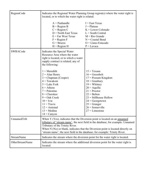
RegionCodeIndicates the Regional Water Planning Group region(s) where the water right islocated, or to which the water right is related.SWRACodeA = PanhandleB = Region BC = Region CD = North East TexasE = Far West TexasF = Region FG = BrazosH = Region HIndicates the Special WaterResource Area where the waterright is located, or to which a watersupply contract is related; any ofthe following:I = East TexasJ = PlateauK = Lower ColoradoL = South CentralM = Rio GrandeN = Coastal BendO = Llano-EstacadoP = LavacaUnnamedTribStreamNameOtherStreamName1 = Meredith2 = Alan Henry3 = Chapman (Cooper)4 = Tawakoni5 = Lake Fork6 = Athens7 = Palestine8 = Cherokee9 = Oak Creek10 = Ivie11 = Travis12 = Amistad13 = Medina14 = Canyon15 = Texana16 = Greenbelt17 = Possum Kingdom18 = Granbury19 = Whitney20 = Aquilla21 = Proctor22 = Belton23 = Stillhouse Hollow24 = Georgetown25 = Granger26 = Somerville27 = LimestoneWhen Y (Yes), indicates that the Diversion point is located on an unnamedtributary of ‘stream name’, the next field in the database; for example: UnnamedTributary of the Trinity River.When N (No) or blank, indicates that the Diversion point is located directly on‘stream name’, the next field in the database; for example: Trinity River.Indicates the stream where the diversion point for the water right is located.Indicates the stream where the additional diversion point for the water right islocated.
CountyName1 = Anderson 52 = Crane 103 = Hartley 154 = McCulloch 205 = San Patricio2 = Andrews 53 = Crockett 104 = Haskell 155 = McLennan 206 = San Saba3 = Angelina 54 = Crosby 105 = Hays 156 = McMullen 207 = Schleicher4 = Aransas 55 = Culberson 106 = Hemphill 157 = Madison 208 = Scurry5 = Archer 56 = Dallam 107 = Henderson 158 = Marion 209 = Shackelford6 = Armstrong 57 = Dallas 108 = Hidalgo 159 = Martin 210 = Shelby7 = Atascosa 58 = Dawson 109 = Hill 160 = Mason 211 = Sherman8 = Austin 59 = Deaf Smith 110 = Hockley 161 = Matagorda 212 = Smith9 = Bailey 60 = Delta 111 = Hood 162 = Maverick 213 = Somervell10 = Bandera 61 = Denton 112 = Hopkins 163 = Medina 214 = Starr11 = Bastrop 62 = De Witt 113 = Houston 164 = Menard 215 = Stephens12 = Baylor 63 = Dickens 114 = Howard 165 = Midland 216 = Sterling13 = Bee 64 = Dimmit 115 = Hudspeth 166 = Milam 217 = Stonewall14 = Bell 65 = Donley 116 = Hunt 167 = Mills 218 = Sutton15 = Bexar 66 = Duval 117 = Hutchinson 168 = Mitchell 219 = Swisher16 = Blanco 67 = Eastland 118 = Irion 169 = Montague 220 = Tarrant17 = Borden 68 = Ector 119 = Jack 170 = Montgomery 221 = Taylor18 = Bosque 69 = Edwards 120 = Jackson 171 = Moore 222 = Terrell19 = Bowie 70 = Ellis 121 = Jasper 172 = Morris 223 = Terry20 = Brazoria 71 = El Paso 122 = Jeff Davis 173 = Motley 224 = Throckmorton21 = Brazos 72 = Erath 123 = Jefferson 174 = Nacogdoches 225 = Titus22 = Brewster 73 = Falls 124 = Jim Hogg 175 = Navarro 226 = Tom Green23 = Briscoe 74 = Fannin 125 = Jim Wells 176 = Newton 227 = Travis24 = Brooks 75 = Fayette 126 = Johnson 177 = Nolan 228 = Trinity25 = Brown 76 = Fisher 127 = Jones 178 = Nueces 229 = Tyler26 = Burleson 77 = Floyd 128 = Karnes 179 = Ochiltree 230 = Upshur27 = Burnet 78 = Foard 129 = Kaufman 180 = Oldham 231 = Upton28 = Caldwell 79 = Fort Bend 130 = Kendall 181 = Orange 232 = Uvalde29 = Calhoun 80 = Franklin 131 = Kenedy 182 = Palo Pinto 233 = Val Verde30 = Callahan 81 = Freestone 132 = Kent 183 = Panola 234 = Van Zandt31 = Cameron 82 = Frio 133 = Kerr 184 = Parker 235 = Victoria32 = Camp 83 = Gaines 134 = Kimble 185 = Parmer 236 = Walker33 = Carson 84 = Galveston 135 = King 186 = Pecos 237 = Waller34 = Cass 85 = Garza 136 = Kinney 187 = Polk 238 = Ward35 = Castro 86 = Gillespie 137 = Kleberg 188 = Potter 239 = Washington36 = Chambers 87 = Glasscock 138 = Knox 189 = Presidio 240 = Webb37 = Cherokee 88 = Goliad 139 = Lamar 190 = Rains 241 = Wharton38 = Childress 89 = Gonzales 140 = Lamb 191 = Randall 242 = Wheeler39 = Clay 90 = Gray 141 = Lampasas 192 = Reagan 243 = Wichita40 = Cochran 91 = Grayson 142 = La Salle 193 = Real 244 = Wilbarger41 = Coke 92 = Gregg 143 = Lavaca 194 = Red River 245 = Willacy42 = Coleman 93 = Grimes 144 = Lee 195 = Reeves 246 = Williamson43 = Collin 94 = Guadalupe 145 = Leon 196 = Refugio 247 = Wilson44 = Collingsworth 95 = Hale 146 = Liberty 197 = Roberts 248 = Winkler45 = Colorado 96 = Hall 147 = Limestone 198 = Robertson 249 = Wise46 = Comal 97 = Hamilton 148 = Lipscomb 199 = Rockwall 250 = Wood47 = Comanche 98 = Hansford 149 = Live Oak 200 = Runnels 251 = Yoakum48 = Concho 99 = Hardeman 150 = Llano 201 = Rusk 252 = Young49 = Cooke 100 =Hardin 151 = Loving 202 = Sabine 253 = Zapata50 = Coryell 101 = Harris 152 = Lubbock 203 = San Augustine 254 = Zavala51 = Cottle 102 = Harrison 153 = Lynn 204 = San JacintoRemarksBaseWRNo and Type(two fields)Indicates any additional information necessary to explain or define the waterright. Once used for displaying amendment dates. SC=Special Condition,SCs=Special Conditions. SCS SITE=Soil Conservation Service Site.For a Contract (type 9), indicates the supplier’s water right number and type.Example: For Contract No. 000088-9, City of San Angelo, the Base Water Rightand Type is 001008-6, Colorado River MWD.
- Page 191 and 192: APPENDIX B
- Page 193 and 194: APPENDIX B0 / ?% '(0 ;6 ) , 6
- Page 195 and 196: APPENDIX B ) ) ) B C * (
- Page 197 and 198: APPENDIX B &# ! % 44' # (0 5#
- Page 199 and 200: APPENDIX B # %# '(=. )1. )@. )
- Page 201 and 202: C O N S U L T I N G E N G I N E E R
- Page 203 and 204: C O N S U L T I N G E N G I N E E R
- Page 205 and 206: State WellNumber6702902670290567029
- Page 207 and 208: State WellNumber6703804670380567038
- Page 209 and 210: State WellNumber6705702670570367058
- Page 211 and 212: State WellNumber6711701671170267117
- Page 213 and 214: State WellNumber6712414671241567124
- Page 215 and 216: State WellNumber6713603671360567136
- Page 217 and 218: State WellNumber6719606671960767196
- Page 219 and 220: State WellNumber6720802672110467212
- Page 221 and 222: APPENDIX EThe tables presented in t
- Page 223 and 224: APPENDIX EWaterUserGroupTABLE 7PROJ
- Page 225 and 226: APPENDIX ERules of the Gonzales Cou
- Page 227 and 228: APPENDIX EAVERAGE QUEEN CITY OR SPA
- Page 229 and 230: Historical Water Use Summary by Cou
- Page 231 and 232: Historical Water Use Summary by Gro
- Page 233 and 234: C O N S U L T I N G E N G I N E E R
- Page 235: UseCodePriority DatePriority Month,
- Page 239 and 240: WRNoWRTypeWRSeqAPPENDIX GTCEQ SURFA
- Page 241 and 242: APPENDIX HWATER CONSERVATION MEASUR
- Page 243 and 244: APPENDIX HWater Rate StructureAn in
- Page 245 and 246: APPENDIX HLeak Detection and Repair
- Page 247 and 248: C O N S U L T I N G E N G I N E E R
- Page 249 and 250: APPENDIX I• The cities of Kyle, L
- Page 251 and 252: C O N S U L T I N G E N G I N E E R
- Page 253 and 254: Management MeasureSeptic System Ins
- Page 255 and 256: Outreach ActivityAgricultural Progr
- Page 257 and 258: APPENDIX KWhereas the parties to th
- Page 259: C O N S U L T I N G E N G I N E E R
- Page 265 and 266: RESPONSE TO WRITTEN COMMENT BY JOHN
- Page 267 and 268: APPENDIX MCaldwell County Regional
- Page 269 and 270: APPENDIX MCaldwell County Regional
- Page 271 and 272: APPENDIX MCaldwell County Regional
- Page 273 and 274: APPENDIX MCaldwell County Regional
- Page 275 and 276: APPENDIX MCaldwell County Regional
- Page 277: APPENDIX NTEXAS WATER DEVELOPMENT B
- Page 282 and 283: APPENDIX NKlotz Associates, Inc.Res
- Page 284 and 285: APPENDIX NKlotz Associates Response
RegionCodeIndicates the Regional Water Planning Group region(s) where the <strong>water</strong> right islocated, or to which the <strong>water</strong> right is related.SWRACodeA = Panh<strong>and</strong>leB = Region BC = Region CD = North East TexasE = Far West TexasF = Region FG = BrazosH = Region HIndicates the Special WaterResource Area where the <strong>water</strong>right is located, or to which a <strong>water</strong>supply contract is related; any ofthe following:I = East TexasJ = PlateauK = Lower ColoradoL = South CentralM = Rio Gr<strong>and</strong>eN = Coastal BendO = Llano-EstacadoP = LavacaUnnamedTribStreamNameOtherStreamName1 = Meredith2 = Alan Henry3 = Chapman (Cooper)4 = Tawakoni5 = Lake Fork6 = Athens7 = Palestine8 = Cherokee9 = Oak Creek10 = Ivie11 = Travis12 = Amistad13 = Medina14 = Canyon15 = Texana16 = Greenbelt17 = Possum Kingdom18 = Granbury19 = Whitney20 = Aquilla21 = Proctor22 = Belton23 = Stillhouse Hollow24 = Georgetown25 = Granger26 = Somerville27 = LimestoneWhen Y (Yes), indicates that the Diversion point is located on an unnamedtributary of ‘stream name’, the next field in the database; for example: UnnamedTributary of the Trinity River.When N (No) or blank, indicates that the Diversion point is located directly on‘stream name’, the next field in the database; for example: Trinity River.Indicates the stream where the diversion point for the <strong>water</strong> right is located.Indicates the stream where the additional diversion point for the <strong>water</strong> right islocated.


