THE GREAT OUTDOORSBIKING TRAILS, continuedEast Central17. MARINERS TRAIL920/684-0828www.marinerstrail.net/Six miles <strong>of</strong> paved lakeshore trail joinManitowoc and Two Rivers passing gardens,sculptures, telescopes, and picnicareas with restroom facilities.18. OLD PLANK ROAD TRAIL800/457-9497www.visitsheboygancounty.comWhat was once a primitive, all plankroad back in pioneer days is now 17miles <strong>of</strong> asphalt paralleling Highway 23between Sheboygan and the historic village<strong>of</strong> Greenbush.19. TRESTLE-FRIENDSHIP &WIOWASH TRAILdnr.wi.gov/topic/parks/name/wiouwash/With a surface <strong>of</strong> crushed stone, thenorthern segment <strong>of</strong> the trail travels 19miles between Birnamwood and SplitRock; the southern segment is open for22 miles from Hortonville to Oshkosh,connecting to the Friendship Trail atState Highway 10 where riders canbranch <strong>of</strong>f to the town <strong>of</strong> Menasha.20. WILD GOOSE STATE TRAIL920/929-3135 or 386-3700, Ext 1dnr.wi.gov/topic/parks/name/wildgoose/This 34-mile crushed stone rail trailskirts the western edge <strong>of</strong> HoriconMarsh National Wildlife Refuge andState Wildlife Area, home to over 250bird species. The trail runs from thetrailhead at State Highway 60 in ClymanJunction to the city <strong>of</strong> Fond du Lac.Central21. MOUNTAIN-BAY STATE TRAIL920/448-4466 or 715/526-5216dnr.wi.gov/topic/parks/name/mountainbay/Named for the two geological features itconnects (Rib Mountain and GreenBay), this crushed stone trail travels for83 miles from Weston on the west toHoward Memorial Park on the east.22. OMAHA TRAIL888/606-2453www.trailsfromrails.com/el_Omaha_trail.htmHighlights <strong>of</strong> this 13 mile paved trailbetween Elroy and Camp Douglasinclude a 300 foot long tunnel andspectacular rock outcroppings not foundanywhere else in the Midwest. In Elroy,excellent biking continues as the OmahaTrail meets the popular “400” andElroy -Sparta State Trails.23. SCHMEEKLE RESERVE/ GREENCIRCLE TRAIL715/346-4992dnr.wi.gov/topic/parks/name/greencircle/Starting at the <strong>Wisconsin</strong> ConservationHall <strong>of</strong> Fame on the UW-Stevens Point’sSchmeeckle Reserve, this 5-mile trailmeanders through wetlands, prairies,and forests on its way to join the GreenCircle Trail. The 31-mile Green CircleTrail follows the scenic Plover and<strong>Wisconsin</strong> Rivers and passes throughthe towns <strong>of</strong> Whiting and Plover.24. TOMORROW RIVER STATETRAIL715/346-1433 or 715/258-6243dnr.wi.gov/topic/parks/name/tomorrowriv/Heading west from Plover to Manawa,this 29-mile paved trail travels throughpeaceful farms nestled amid glacial terrain.A one mile gap in AmherstJunction requires users to follow localroads for the trail route.South East25. BUGLINE TRAIL262/548-7801www.traillink.com/trail/bugline-trail.aspxThis unique 12-mile trail connectsMenomonee Falls with the Village <strong>of</strong>Merton. The trail features a close-upview <strong>of</strong> the cavernous Lannon Quarrywhich mines the very limestone used topave the trail.26. EISENBAHN STATE TRAIL888/338-8666dnr.wi.gov/topic/parks/name/eisenbahn/This “rail-trail” occupying the formerChicago and North Western Railroadcorridor between West Bend and Edenis named for the German “iron road.”Half <strong>of</strong> the 25 mile route is asphalt; theother half is crushed stone.27. GLACIAL DRUMLIN STATETRAIL920/648-8774 or 262/646-3025dnr.wi.gov/topic/parks/name/glacialdrumlin/This trail stretches through 52 miles <strong>of</strong>beautiful glacial drumlin topography andten small towns. One <strong>of</strong> the longest <strong>of</strong>the state’s trails, it includes 13 miles <strong>of</strong>asphalt and 39 <strong>of</strong> crushed stone.28. HANK AARON STATE TRAIL414/263-8559dnr.wi.gov/topic/parks/name/hankaaron/Named for baseball’s legendary HankAaron, this 8-mile asphalt trail providesa continuous link between Milwaukee’sMiller Park Stadium and the LakeMichigan lakefront.29. INTERURBAN TRAIL800/403-9898www.interurbantrail.us/This trail boasts nearly 30 miles <strong>of</strong>paved trail passes throughThiensville/Mequon, Cedarburg, Grafton,Port Washington and Belgium to theSheboygan County line.30. LAKE COUNTRY RECREATIONTRAIL262/548-7801www.traillink.com/trail/lake-countryrecreation-trail.aspxThis 13-mile asphalt and crushed stonetrail stretches between Roosevelt FieldPark in downtown Oconomowoc andCushing Park in downtown Delafield.31. NEW BERLIN RECREATIONTRAIL262/548-7801www.traillink.com/trail/new-berlinrecreation-trail.aspxSeven paved miles from South 124thStreet at the Milwaukee/ WaukeshaCounty line to Lincoln Avenue in30 Find more fun at travelwisconsin.com or call 1-800/432-8747.Waukesha connect to the Oak Leaf Trailin Greenfield and the Glacial DrumlinState Trail in Waukesha.32. WHITE RIVER STATE TRAIL262/741-3114dnr.wi.gov/topic/parks/name/whiteriver/Twelve miles <strong>of</strong> crushed limestone passover bridges and through scenic vistasfrom Elkhorn east to Burlington.South Central33. BADGER STATE TRAIL608/ 527-2335 or 888/222-9111dnr.wi.gov/topic/parks/name/badger/This 40-mile trail features the 1,200 footlong Stewart Tunnel. The Badger Trailconnects to the Capital City, MilitaryRidge, and Sugar River State Trails andthe Madison bikeway system as itmakes its way from Madison to the<strong>Wisconsin</strong>- Illinois border. About 6miles <strong>of</strong> the trail is asphalt; the rest iscrushed stone.34. “400” STATE TRAIL800/844-3507dnr.wi.gov/topic/parks/name/400/The old Chicago-Northwestern passengertrain on this corridor traveled the400 miles between Chicago andMinneapolis in just 400 minutes. Take aslower pace as you traverse sandstonebluffs and rolling croplands, repeatedlycrisscrossing the Baraboo River on this22-mile crushed limestone trail.35. GLACIAL RIVER STATE TRAIL888/733-3678dnr.wi.gov/topic/parks/name/greatriver/A beautiful metal archway in downtownFort Atkinson marks the trailhead forthis 8.6-mile, mostly paved trail endingat the Jefferson/ Rock County line.Highlights include rest areas, fountains,and Indian Mounds Park, a collection <strong>of</strong>11 large animal shaped earthworks withreligious ceremonial origins dating backover 1,500 years.36. JANESVILLE-SPRING BROOKTRAIL608/755-3030www.traillink.com/trail/spring-brooktrail.aspxPart <strong>of</strong> the Ice Age Corridor, this 6-milepaved trail begins at a central trail hubjust north <strong>of</strong> the railroad bridge spanningthe Rock River and connectsdowntown Janesville with the beautifulRotary Botanical Gardens, Palmer Park,and the Youth Sports Complex, endingon the north at Highway 14.37. MILITARY RIDGE STATE TRAIL608/437-7393dnr.wi.gov/topic/parks/name/militaryridge/The 1855 military route between Veronaand Dodgeville is now a 40-milecrushed stone (2.5 miles are asphalt)trail. Skirting the southern edges <strong>of</strong>Governor Dodge and Blue Mounds StateParks, there are observation platformsadjacent to the trail for viewing wildlifeand other natural features. Park at thetrailhead at County Highway PB/ StateHighway 151 and at the western end <strong>of</strong>the trail at the DNR center in Dodgeville.38. CAPITAL CITY STATE TRAIL608/224-3730dnr.wi.gov/topic/parks/name/capcity/Winding around and through the city <strong>of</strong>Madison, these 17 miles <strong>of</strong> paved trailgo past some spectacular city sitesbefore passing through the scenicCapital Springs State Recreation Areabefore linking with the Military Ridge,Badger, and Glacial Drumlin State Trails.39. SUGAR RIVER STATE TRAIL608/527-2334dnr.wi.gov/topic/parks/name/sugarriver/Designated a National Recreational Trail,these 24 miles <strong>of</strong> crushed stone tracean old railroad route between the picturesquevillage <strong>of</strong> New Glarus and the railroadtown <strong>of</strong> Brodhead. Along the way,the trail crosses 14 trestle bridges and acovered bridge over the Sugar River.South West40. ELROY-SPARTA STATE TRAIL608/463-7109 or 608/269-4123dnr.wi.gov/topic/parks/name/elroysparta/With three rock tunnels and five smalltowns along its 32.5-mile crushed limestoneroute, this first rail-to-trail in theUS remains one <strong>of</strong> the most popularbike trails in the country. Travellingbetween Sparta and Elroy, riders shouldcarry a flashlight and be prepared towalk their bikes through the tunnels.41. GREAT RIVER STATE TRAIL608/534-6409dnr.wi.gov/topic/parks/name/greatriver/Riders will enjoy the changing wetlands<strong>of</strong> the Mississippi River backwaters,500-foot bluffs, hardwood forests, sandprairies, and oak savannahs on this 24-mile, crushed limestone trail which runsfrom Trempealeau to Onalaska.42. HILLSBORO STATE TRAIL608/489-2521 or 608/637-5485dnr.wi.gov/topic/parks/name/hillsboro/Four miles <strong>of</strong> crushed stone trail connectthe towns <strong>of</strong> Hillsboro and UnionCenter, while crossing wooded and agriculturallands, winding streams, and thebucolic Baraboo River. The trail connectsto the 400 State Trail and theElroy-Sparta State Trail.43. LA CROSSE RIVER STATE TRAIL800/354-2453 or 608/269-4123dnr.wi.gov/topic/parks/name/lacrosseriv/Packed limestone screenings provide asmooth biking surface on this 22-miletrail connecting the Elroy-Sparta Trail inSparta on the east end and the GreatRiver state Trail in La Crosse on the westend. Along the route, West Salem <strong>of</strong>ferssome interesting sites to see includingthe home <strong>of</strong> famed author HamlinGarland and the unique Palmer-Gullickson Octagon Home.44. PINE RIVER TRAIL608/647-6205www.richlandchamber.com/recreation.htmlThis 14-mile, crushed stone trail, runningfrom Lone Rock to Richland Centeris closed during gun deer hunting season.Travel Green <strong>Wisconsin</strong> Certified
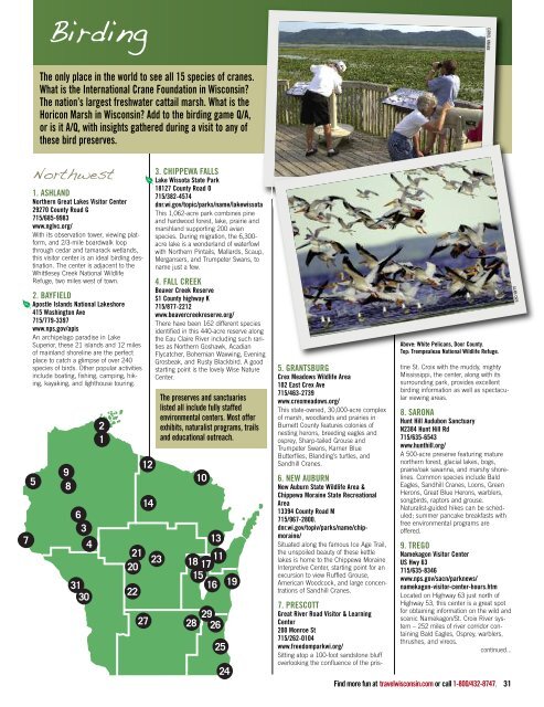
BirdingCAROL KNABEThe only place in the world to see all 15 species <strong>of</strong> cranes.What is the International Crane Foundation in <strong>Wisconsin</strong>?The nation’s largest freshwater cattail marsh. What is theHoricon Marsh in <strong>Wisconsin</strong>? Add to the birding game Q/A,or is it A/Q, with insights gathered during a visit to any <strong>of</strong>these bird preserves.7Northwest1. ASHLANDNorthern Great Lakes Visitor Center29270 County Road G715/685-9983www.nglvc.org/With its observation tower, viewing platform,and 2/3-mile boardwalk loopthrough cedar and tamarack wetlands,this visitor center is an ideal birding destination.The center is adjacent to theWhittlesey Creek National WildlifeRefuge, two miles west <strong>of</strong> town.2. BAYFIELDApostle Islands National Lakeshore415 Washington Ave715/779-3397www.nps.gov/apisAn archipelago paradise in LakeSuperior, these 21 islands and 12 miles<strong>of</strong> mainland shoreline are the perfectplace to catch a glimpse <strong>of</strong> over 240species <strong>of</strong> birds. Other popular activitiesinclude boating, fishing, camping, hiking,kayaking, and lighthouse touring.59863431302121202212143. CHIPPEWA FALLSLake Wissota State Park18127 County Road O715/382-4574dnr.wi.gov/topic/parks/name/lakewissotaThis 1,062-acre park combines pineand hardwood forest, lake, prairie andmarshland supporting 200 avianspecies. During migration, the 6,300-acre lake is a wonderland <strong>of</strong> waterfowlwith Northern Pintails, Mallards, Scaup,Mergansers, and Trumpeter Swans, toname just a few.4. FALL CREEKBeaver Creek ReserveS1 County highway K715/877-2212www.beavercreekreserve.org/There have been 162 different speciesidentified in this 440-acre reserve alongthe Eau Claire River including such raritiesas Northern Goshawk, AcadianFlycatcher, Bohemian Waxwing, EveningGrosbeak, and Rusty Blackbird. A goodstarting point is the lovely Wise NatureCenter.23The preserves and sanctuarieslisted all include fully staffedenvironmental centers. Most <strong>of</strong>ferexhibits, naturalist programs, trailsand educational outreach.10131118 171516 1927 28 29 2625245. GRANTSBURGCrex Meadows Wildlife Area102 East Crex Ave715/463-2739www.crexmeadows.org/This state-owned, 30,000-acre complex<strong>of</strong> marsh, woodlands and prairies inBurnett County features colonies <strong>of</strong>nesting herons, breeding eagles andosprey, Sharp-tailed Grouse andTrumpeter Swans, Karner BlueButterflies, Blanding’s turtles, andSandhill Cranes.6. NEW AUBURNNew Auburn State Wildlife Area &Chippewa Moraine State RecreationalArea13394 County Road M715/967-2800.dnr.wi.gov/topiv/parks/name/chipmoraine/Situated along the famous Ice Age Trail,the unspoiled beauty <strong>of</strong> these kettlelakes is home to the Chippewa MoraineInterpretive Center, starting point for anexcursion to view Ruffled Grouse,American Woodcock, and large concentrations<strong>of</strong> Sandhill Cranes.Above: White Pelicans, Door County.Top: Trempealeau National Wildlife Refuge.7. PRESCOTTGreat River Road Visitor & LearningCenter200 Monroe St715/262-0104www.freedomparkwi.org/Sitting atop a 100-foot sandstone bluffoverlooking the confluence <strong>of</strong> the pristineSt. Croix with the muddy, mightyMississippi, the center, along with itssurrounding park, provides excellentbirding information as well as spectacularviewing areas.8. SARONAHunt Hill Audubon SanctuaryN2384 Hunt Hill Rd715/635-6543www.hunthill.org/A 500-acre preserve featuring maturenorthern forest, glacial lakes, bogs,prairie/oak savanna, and marshy shorelines.Common species include BaldEagles, Sandhill Cranes, Loons, GreenHerons, Great Blue Herons, warblers,songbirds, raptors and grouse.Naturalist-guided hikes can be scheduled;summer pancake breakfasts withfree environmental programs are<strong>of</strong>fered.9. TREGONamekagon Visitor CenterUS Hwy 63715/635-8346www.nps.gov/sacn/parknews/namekagon-visitor-center-hours.htmLocated on Highway 63 just north <strong>of</strong>Highway 53, this center is a great spotfor obtaining information on the wild andscenic Namekagon/St. Croix River system– 252 miles <strong>of</strong> river corridor containingBald Eagles, Osprey, warblers,thrushes, and vireos.continued...Find more fun at travelwisconsin.com or call 1-800/432-8747. 31ALAN ORR