
You also want an ePaper? Increase the reach of your titles
YUMPU automatically turns print PDFs into web optimized ePapers that Google loves.
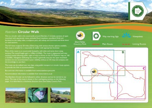
<strong>Aberdare</strong> <strong>Circular</strong> <strong>Walk</strong><br />
This is a circular walk in the countryside around <strong>Aberdare</strong>. It includes sections of open<br />
moorland with spectacular views, secluded flood meadows, woodland, ffridd and<br />
farmland on the valley sides, a sculpture park, old railway and tramroad, and three short<br />
on road sections.<br />
The full route is approx 20 miles (32km) long, with various shorter options available.<br />
The route is suitable for a reasonably fit walker with appropriate footwear.<br />
Most of the route is on countryside footpaths, with stiles and some short steep<br />
sections. The overall height gain is 1,096m (3,596ft). The route is signposted and waymarked,<br />
mostly following public rights of way, as shown on the OS Explorer map no. 166<br />
(1:25,000). Navigation (following the route) is generally easy, but the open moorland<br />
sections are not recommended in poor visibility, without an OS map and compass, and<br />
the knowledge to use them.<br />
The route can be walked over two days, using public transport or circular route options<br />
to provide the links to accommodation.<br />
Bus and train information is available from www.traveline-cymru.info<br />
Accommodation information is available from www.visitrct.co.uk<br />
The <strong>Aberdare</strong> <strong>Circular</strong> can be followed in either direction and can be started at any<br />
point. The map of the route is shown in four overlapping sections on the following<br />
pages. It is described in a clockwise direction from Dare Valley Country Park.<br />
A<br />
B<br />
C<br />
D
A<br />
Hirwaun<br />
NW section: Dare Valley Country Park to Hirwaun<br />
(5.5 miles / 9 kms, 1200ft / 370m height gain)<br />
From the Visitor Centre at Dare Valley follow the main path and turn off to<br />
the left up the hill to Craig Penrhiw-llech and Taren y Bwllfa. Follow the path<br />
around the top of the Cwm and continue along the ridge to Cefn-y-gyngon.<br />
The path zigzags down steeply to cross reclaimed fields to the A4059 (buses<br />
to <strong>Aberdare</strong>), across the road a footpath leads to the Penywaun Tramroad,<br />
under the A465 and into the village of Hirwaun (buses to <strong>Aberdare</strong>).<br />
A circular walk from <strong>Aberdare</strong> town centre can be followed using the<br />
community route from <strong>Aberdare</strong> Library to Dare Valley, this section<br />
of route and returning via the Penywaun tramroad to Tesco’s<br />
and the Cynon Valley Museum in <strong>Aberdare</strong>.<br />
(9miles / 15km, 1600ft / 470m)<br />
© Crown copyright and database rights 2013<br />
Ordnance Survey LA 100023458
B<br />
Hirwaun<br />
NE section: Hirwaun to Abernant:<br />
(4 miles / 6.5 kms, 330ft / 100m height gain)<br />
From Hirwaun follow Swansea Road and turn right on to the footpath under the A465. The<br />
path follows an old canal or feeder route through floodplain meadows and woodland to<br />
the outskirts of Llwydcoed, turn left on the road for a short distance then right<br />
onto the disused railway from Llwydcoed to Cwmbach.<br />
A circular walk from <strong>Aberdare</strong> town centre can be followed using<br />
the Penywaun Tramroad from Tescos/ Cynon Valley Museum to<br />
Hirwaun and the Abernant road from the disused railway<br />
(by the Rhos Wenallt Hotel) back to the town centre.<br />
(9 miles / 14 km, 750ft / 225m height gain)<br />
Abernant<br />
© Crown copyright and database rights 2013<br />
Ordnance Survey LA 100023458
C<br />
Abernant<br />
SE Section: Abernant to Fernhill<br />
(4.5 miles / 7km, 980ft / 300m height gain)<br />
Continue on the disused railway to Cwmbach follow the footpath to<br />
Blaennantygroes Road, and after a short section down the road take the<br />
footpath on the left through the fields. The path climbs up the hillside into<br />
forest to Cefn Pennar Uchaf and then up again on an old walled lane.<br />
Skirting around the enclosed fields and then downhill across an old colliery<br />
tip, the view opens out. In Cwmpennar cross the road, continue<br />
downhill to the New Road A4059, cross on the footbridge and<br />
through Peace Park across the railway (take care) and stream<br />
to the <strong>Aberdare</strong> Road B4275 (Fernhill station for trains<br />
north to <strong>Aberdare</strong> or south to Mountain<br />
Ash/Pontypridd/Cardiff and buses in both<br />
directions on B4275).<br />
Fernhill<br />
© Crown copyright and database rights 2013<br />
Ordnance Survey LA 100023458
D<br />
SW section: Fernhill to Dare Valley<br />
(5 miles / 9km, 1100ft / 330m height gain)<br />
Follow the pavement along the B4275 for a short distance, cross the road and go left up the hill and right<br />
on to the path behind Abercwmboi. Follow this route along the valley side into Cwm Aman. Cross<br />
Llanwonno Road, through the sculpture Park by St Joseph’s Church and Environment Centre<br />
into the village of Cwmaman (buses to <strong>Aberdare</strong>). Turn left on to Mountain Road and<br />
then left on to the old miners track leading out of the valley and over the hill<br />
(Rhos-gwawr). Skirting the edge of the hairpin on the A4233, follow the<br />
path downhill through Dumfries Park to cross the A4233 (take care!)<br />
and down again to join the Dare Valley entrance road.<br />
A circular walk from Cwmaman or Dare Valley Country<br />
Park uses the Rhos-gwawr / Dumfries Park section<br />
combined with the Dare Aman community<br />
route on the former railway line between<br />
Dare Valley and Cwmaman. (6miles /<br />
10km, 900ft / 270m height gain)<br />
© Crown copyright and database rights 2013<br />
Ordnance Survey LA 100023458<br />
Fernhill