Buzzard Roost Trail - Indiana Outfitters
Buzzard Roost Trail - Indiana Outfitters
Buzzard Roost Trail - Indiana Outfitters

You also want an ePaper? Increase the reach of your titles
YUMPU automatically turns print PDFs into web optimized ePapers that Google loves.
<strong>Buzzard</strong> <strong>Roost</strong> <strong>Trail</strong><br />
USDA Forest Service Hoosier National Forest 7/2010<br />
Description<br />
Approximate Length: 0.8 mile<br />
Type: Hiking. The loop trail begins on the bluff<br />
overlooking the Ohio River and descends to the<br />
river adjacent to a creek. The trail is marked with<br />
white diamonds.<br />
Special Features: Sandstone rock outcrops,<br />
bluffs, hardwood forest, cool shade, waterfalls,<br />
view of the Ohio River and Kentucky.<br />
Etiquette and Rules<br />
Motorized vehicles, horses, and bicycles are not<br />
permitted on this trail.<br />
Pack out your trash.<br />
Safety<br />
Use caution during hunting seasons. Blaze orange<br />
clothing is recommended (do not wear white)<br />
during deer season.<br />
If a parking lot is not available where you wish<br />
access, be sure your vehicle is well off the road.<br />
Many trails intersect roadways. If you choose to<br />
use a road as part of your trip, be mindful of traffic.<br />
Ticks and chiggers are prevalent in southern <strong>Indiana</strong>.<br />
Take necessary precautions including avoiding<br />
tall grass and thick brushy areas.<br />
Loose limbs and hazard trees can fall on the trail<br />
at anytime, especially on windy days.<br />
Emergencies<br />
• Nearest public phone is located in Sulphur, IN.<br />
• The nearest hospital is located in Tell City, IN.<br />
• Crawford County Sheriff: 812-338-2802 or 911.<br />
• <strong>Indiana</strong> Conservation Officers: 812-837-9536.<br />
Facilities<br />
Parking is available in two parking areas along the<br />
entrance road and at the first trail access, parking<br />
is also available in the camping/picnic loop.<br />
Benches are located on the bluffs overlooking the<br />
Ohio River and on the bluff where the trail meets<br />
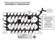
the river. See map on reverse.<br />
An overlook area provides a beautiful view of the<br />
Directions<br />
Location Map<br />
!( 62 !( 66<br />
Oriole !(<br />
From I-64: Take the IN 237/66 exit for English/<br />
Sulphur south toward Sulphur. At Sulphur, there is<br />
a 3-way intersection, to get to <strong>Buzzard</strong> <strong>Roost</strong> continue<br />
south on IN 66 through the community of Oriole.<br />
Turn off State Highway 66, 1.5 miles south<br />
of Oriole onto the first road east (Onido Road) and<br />
follow it bearing to the right at the intersection of<br />
Onido and Orchard Roads. Continue on Onido<br />
Road to the marked entrance of <strong>Buzzard</strong> <strong>Roost</strong>.<br />
Turn left at the entrance sign.<br />
For More Information<br />
Hoosier National Forest<br />
248 15th Street<br />
Tell City, IN 47586<br />
(812) 547-7051<br />
Toll Free: 1-866-302-4173<br />
www.fs.fed.us/r9/hoosier<br />
!(<br />
Sulphur<br />
Federal Relay Number for the deaf and<br />
hearing impaired is: 1-800-877-8339<br />
USDA is an equal opportunity employer<br />
and provider<br />
!(<br />
!(<br />
§¨¦ 64<br />
!( 37 !( 70 !( 62 Alton<br />
Derby<br />
Oni<br />
do<br />
<strong>Trail</strong><br />
Location<br />
Rd<br />
Magnet<br />
O H I O<br />
!(<br />
±<br />
R I V E R<br />
0 1 2 3 4<br />
Miles<br />
Ohio River. A primitive camping/picnic area with<br />
tables and grills is available. No toilets or water.
<strong>Buzzard</strong> <strong>Roost</strong> <strong>Trail</strong><br />
Dexter<br />
Magnet Rd<br />
!j<br />
.5<br />
O H I O R I V E R<br />
Large Print Copies Available on Request<br />
Look for these symbols to be sure you are on an<br />
official trail:<br />
(<br />
Y<br />
Colored<br />
Dot or<br />
Diamond<br />
!F<br />
!G<br />
!È<br />
Post<br />
with decals<br />
<strong>Trail</strong>s may be color coded to indicate use type:<br />
Blue - Hiking, Mountain Bike, and Horse Riding<br />
Yellow - Hiking and Mountain Biking Only<br />
White - Hiking Only<br />
0 0.125 0.25 0.5<br />
Mile<br />
Legend<br />
<strong>Trail</strong><br />
Road<br />
Stream<br />
Contour Line<br />
±<br />
Water<br />
Forest Service<br />
Miles Between<br />
.5<br />
Intersections<br />
!j Parking