SCOP++ - Norconsult
SCOP++ - Norconsult
SCOP++ - Norconsult

You also want an ePaper? Increase the reach of your titles
YUMPU automatically turns print PDFs into web optimized ePapers that Google loves.
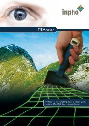
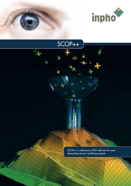
<strong>SCOP++</strong><br />
<strong>SCOP++</strong> is well-proven DTM software for most<br />
demanding terrain modeling projects.
<strong>SCOP++</strong> – Well-proven performance<br />
for terrain modeling.<br />
Merging different DTM views<br />
(contours, hill-shading and Z-coding)<br />
with a raster map<br />
<strong>SCOP++</strong> is designed for efficient handling of DTM projects of any size,<br />
with data coming from LIDAR, photogrammetry or any other source.<br />
<strong>SCOP++</strong> provides unsurpassed quality of DTM interpolation, filtering,<br />
management, application and visualization.<br />
All modules of <strong>SCOP++</strong> are made for<br />
processing many millions of DTM points.<br />
With its integrated database system<br />
<strong>SCOP++</strong> is especially well-suited for very<br />
large DTM projects, up to nation-wide<br />
DTMs.<br />
A complete solution for powerful filtering,<br />
classification, quality control and editing<br />
of LIDAR data is offered with LIDAR Box,<br />
consisting of <strong>SCOP++</strong> Kernel, <strong>SCOP++</strong><br />
LIDAR and inpho’s DTM editing station<br />
DTMaster.<br />
<strong>SCOP++</strong> works with a very efficient hybrid<br />
DTM data structure and flexible, advanced<br />
interpolation methods. This guarantees<br />
for rigorous consideration of break lines<br />
and qualified data filtering.<br />
Image Capture<br />
Aerial Triangulation<br />
Data Capture<br />
Terrain Modeling<br />
Orthophoto Processing<br />
<strong>SCOP++</strong> LIDAR filtering with<br />
classification for terrain points<br />
and off-terrain points.
<strong>SCOP++</strong>’s flexible architecture allows<br />
for a variety of DTM operations and<br />
visualizations.<br />
Features<br />
• With its task-oriented modular structure,<br />
<strong>SCOP++</strong> can be easily adapted to<br />
customers’ needs. <strong>SCOP++</strong> Kernel is<br />
mandatory. All other modules are<br />
optional extensions.<br />
• <strong>SCOP++</strong> Kernel<br />
· Precise DTM interpolation with or without<br />
filtering<br />
· Generation of DTMs consisting of up to<br />
one billion (10 9 ) points<br />
· Data densification and data reduction<br />
· Contouring with cartographic quality<br />
· Basic profiling<br />
· Flexible Z-coding and hill-shading<br />
· Integrated raster and vector graphics<br />
· Combination of geo-referenced raster<br />
graphics (e.g. digital map) with DTM<br />
views like hill-shading or contours<br />
· Supported formats:<br />
· Data: Winput, DXF, XYZ, ArcInfo Generate,<br />
LAS (ASPRS Lidar data exchange format)<br />
· Graphics: DXF, HPGL, TIFF, JPEG, PDF<br />
· DTM: SCOP DTM, ArcInfo Grid, XYZ,<br />
DTED, VRML, Winput, DXF<br />
• <strong>SCOP++</strong> Analyzer<br />
· DTM algebra (including difference DTMs)<br />
· Volume computation<br />
· Profiling, cross-sections<br />
· Digital slope models and slope maps<br />
· Mosaicking and feathering of overlapping<br />
DTMs<br />
• <strong>SCOP++</strong> LIDAR<br />
· Filtering of air-borne laser scanning data<br />
for automatic classification of the raw point<br />
cloud into terrain and off-terrain points,<br />
i. e. for extracting the true ground points<br />
for further DTM processing<br />
· Efficient robust interpolation techniques with<br />
flexible adaption to terrain type and terrain<br />
coverage<br />
· User-controlled hierarchical process using<br />
point cloud pyramids<br />
· Elimination of gross errors in any DTM data<br />
• <strong>SCOP++</strong> TopDM<br />
· Topographic Data Management designed<br />
for storing, managing and archiving<br />
nationwide digital elevation information<br />
· Geocoded relational data base<br />
· Georeferencing (map projections and<br />
coordinate transformations, geodetic datum<br />
transformations)<br />
· Management of DTM data: DTM selection<br />
and export; merging DTMs; extracting parts<br />
from DTMs; DTM resampling<br />
· On request: interfacing with ORACLE databases<br />
• Additional functionality coming soon:<br />
· DTM quality layer and derivation of quality<br />
measures from DTM data<br />
· TIN generation and export<br />
Benefits<br />
• Well-proven, advanced DTM technology.<br />
• Advanced modules available for preand<br />
post-processing of DTM data.<br />
• Easy integration into any third-party workflow.<br />
Recommendations<br />
• High-end PC workstation<br />
• 2 Gbyte RAM<br />
• Windows XP/2000<br />
• To complete the workflow of DTM processing,<br />
in addition to <strong>SCOP++</strong>, inpho’s<br />
product DTMaster is recommended for<br />
quality control and editing of DTM data.<br />
<strong>SCOP++</strong> is a joint trademark of inpho GmbH<br />
and Institute of Photogrammetry and Remote<br />
Sensing, Technical University Vienna. All other<br />
brands and product names are trademarks of<br />
their respective owners.<br />
• <strong>SCOP++</strong> Visualizer<br />
· Perspective DTM views in form of raster<br />
graphics generated by <strong>SCOP++</strong> Kernel,<br />
or of wire-frame models<br />
· Panoramic views with annotation<br />
of geographic names<br />
· Silhouette views<br />
• High productivity through effective,<br />
high capacity data processing and batch<br />
processing capabilities.<br />
• Suited for seamless management of<br />
nation-wide DTMs.<br />
• Unsurpassed DTM quality through<br />
precise interpolation and filtering.<br />
inpho’s development partner for<br />
<strong>SCOP++</strong> is the Institute of<br />
Photogrammetry and Remote<br />
Sensing of the Technical University<br />
Vienna, www.ipf.tuwien.ac.at
Image Capture<br />
Aerial Triangulation<br />
Data Capture<br />
Terrain Modeling<br />
Orthophoto Processing<br />
For further information,<br />
please contact:<br />
inpho GmbH<br />
Smaragdweg 1<br />
70174 Stuttgart<br />
Germany<br />
Tel.: +49-711-228810<br />
Fax: +49- 7 11 - 22 88 111<br />
E-mail: sales@inpho.de<br />
www.inpho.de<br />
Information is subject to change without notice.