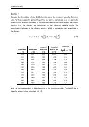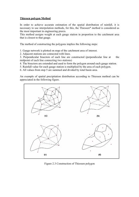
Thiessen polygon Method In order to achieve accurate estimation of ...
Thiessen polygon Method In order to achieve accurate estimation of ...
Thiessen polygon Method In order to achieve accurate estimation of ...

Create successful ePaper yourself
Turn your PDF publications into a flip-book with our unique Google optimized e-Paper software.
<strong>Thiessen</strong> <strong>polygon</strong> <strong>Method</strong><br />
<strong>In</strong> <strong>order</strong> <strong>to</strong> <strong>achieve</strong> <strong>accurate</strong> <strong>estimation</strong> <strong>of</strong> the spatial distribution <strong>of</strong> rainfall, it is<br />
necessary <strong>to</strong> use interpolation methods, for this, the <strong>Thiessen</strong>* method is considered as<br />
the most important in engineering praxis.<br />
This method assigns weight at each gauge station in proportion <strong>to</strong> the catchment area<br />
that is closest <strong>to</strong> that gauge.<br />
The method <strong>of</strong> constructing the <strong>polygon</strong>s implies the following steps:<br />
1. Gauge network is plotted on map <strong>of</strong> the catchment area <strong>of</strong> interest.<br />
2. Adjacent stations are connected with lines.<br />
3. Perpendicular bisec<strong>to</strong>rs <strong>of</strong> each line are constructed (perpendicular line at the<br />
midpoint <strong>of</strong> each line connecting two stations)<br />
4. The bisec<strong>to</strong>rs are extended and used <strong>to</strong> form the <strong>polygon</strong> around each gauge station.<br />
5. Rainfall value for each gauge station is multiplied by the area <strong>of</strong> each <strong>polygon</strong>.<br />
6. All values from step 5 are summed and divided by <strong>to</strong>tal basin area.<br />
An example <strong>of</strong> spatial precipitation distribution according <strong>to</strong> <strong>Thiessen</strong> method can be<br />
appreciated in the following figure.<br />
Figure 2.3 Construction <strong>of</strong> <strong>Thiessen</strong> <strong>polygon</strong>
Although it is widely used in engineering praxis, this method has its shortcomings. For<br />
example, in mountainous areas, an irregular spatial distribution <strong>of</strong> precipitation can be<br />
formed over small distances, and for such circumstances the <strong>Thiessen</strong> method can yield<br />
erroneous results. <strong>In</strong> <strong>order</strong> <strong>to</strong> overcome these problems, more <strong>accurate</strong> methods are<br />
used, in which the whole area is “rastered” and each <strong>of</strong> those rasters are calculated<br />
according <strong>to</strong> the quadrant method.