


You also want an ePaper? Increase the reach of your titles
YUMPU automatically turns print PDFs into web optimized ePapers that Google loves.
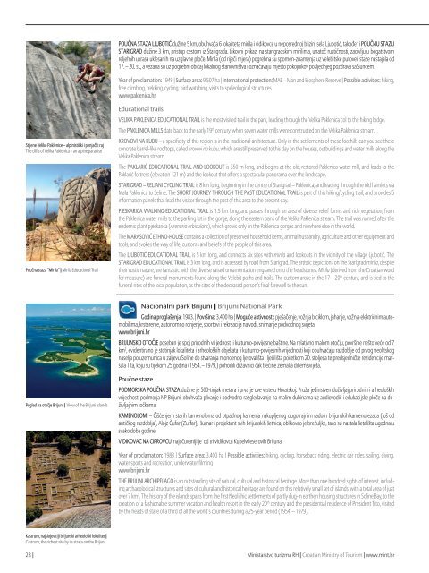
POUČNA STAZA LJUBOTIĆ dužine 5 km, obuhvaća 6 lokaliteta mirila i vidikovce u neposrednoj blizini sela Ljubotić, također i POUČNU STAZU<br />
STARIGRAD dužine 3 km, pristup cestom iz Starigrada. Likovni prikazi na starigradskim mirilima, unatoč rustičnosti, zadivljuju bogatstvom<br />
reljefnih ukrasa uklesanih na uzglavne ploče. Mirila (od riječi mjera) pogrebna su spomen-znamenja uz velebitske putove i staze nastajala od<br />
17. – 20. st., a vezana su uz pogrebni običaj lokalnog stanovništva i označavaju mjesto pokojnikov posljednjeg pozdrava sa Suncem.<br />
Year of proclamation: 1949 | Surface area: 9,507 ha | International protection: MAB – Man and Biosphere Reserve | Possible activities: hiking,<br />
free climbing, trekking, cycling, bird watching, visits to speleological structures<br />
www.paklenica.hr<br />
Stijene Velike Paklenice – alpinistički i penjački raj |<br />
The cliffs of Velika Paklenica – an alpine paradise<br />
Poučna staza “Mirila” | Mirila Educational Trail<br />
Educational trails<br />
VELIKA PAKLENICA EDUCATIONAL TRAIL is the most visited trail in the park, leading through the Velika Paklenica col to the hiking lodge.<br />
The PAKLENICA MILLS date back to the early 19 th century, when seven water mills were constructed on the Velika Paklenica stream.<br />
KROVOVI NA KUBU – a specificity of this region is in the traditional architecture. Only in the settlements of these foothills can you see these<br />
concrete barrel-like rooftops, called krovovi na kubu, which are still preserved to this day on the houses, outbuildings and water mills along the<br />
Velika Paklenica stream.<br />
The PAKLARIĆ EDUCATIONAL TRAIL AND LOOKOUT is 550 m long, and begins at the old, restored Paklenica water mill, and leads to the<br />
Paklarić fortress (elevation 121 m) and the lookout that offers a spectacular panorama over the landscape.<br />
STARIGRAD – RELJANI CYCLING TRAIL is 8 km long, beginning in the centre of Starigrad – Paklenica, and leading through the old hamlets via<br />
Mala Paklenica to Seline. The SHORT JOURNEY THROUGH THE PAST EDUCATIONAL TRAIL is part of this hiking/cycling trail, and provides 5<br />
information panels that lead the visitor through the past of this area to the present day.<br />
PJESKARICA WALKING-EDUCATIONAL TRAIL is 1.5 km long, and passes through an area of diverse relief forms and rich vegetation, from<br />
the Paklenica water mills to the parking lot in the gorge, along the eastern bank of the Velika Paklenica stream. The trail was named after the<br />
endemic plant pjeskarica (Arenaria orbicularis), which grows only in the Paklenica gorges and nowhere else in the world.<br />
The MARASOVIĆ ETHNO-HOUSE contains a collection of preserved household items, animal husbandry, agriculture and other equipment and<br />
tools, and evokes the way of life, customs and beliefs of the people of this area.<br />
The LJUBOTIĆ EDUCATIONAL TRAIL is 5 km long, and connects six sites with mirila and lookouts in the vicinity of the village Ljubotić. The<br />
STARIGRAD EDUCATIONAL TRAIL is 3 km long, and is accessed by road from Starigrad. The artistic depictions on the Starigrad mirila, despite<br />
their rustic nature, are fantastic with the diverse raised ornamentation engraved onto the headstones. Mirila (derived from the Croatian word<br />
for measure) are funeral monuments found along the Velebit paths and trails. The custom arose in the 17 – 20 th century, and is tied to the<br />
funeral rites of the local population, as the sites of the deceased person’s final farewell to the sun.<br />
Nacionalni park Brijuni | Brijuni National Park<br />
Godina proglašenja: 1983. | Površina: 3.400 ha | Moguće aktivnosti: pješačenje, vožnja biciklom, jahanje, vožnja električnim automobilima,<br />
krstarenje, autonomno ronjenje, sportovi i rekreacija na vodi, snimanje podvodnog svijeta<br />
www.brijuni.hr<br />
BRIJUNSKO OTOČJE poseban je spoj prirodnih vrijednosti i kulturno-povijesne baštine. Na relativno malom otočju, površine nešto veće od 7<br />
km 2 , evidentirano je stotinjak lokaliteta i arheoloških objekata i kulturno-povijesnih vrijednosti koji obuhvaćaju razdoblje od prvog neolitskog<br />
naselja poluzemunica u zaljevu Soline do stvaranja mondenog ljetovališta i lječilišta početkom 20. stoljeća te predsjedničke rezidencije maršala<br />
Tita, koju su tijekom 25 godina (1954. – 1979.) pohodili državnici čak trećine zemalja diljem svijeta.<br />
Pogled na otočje Brijuni | View of the Brijuni islands<br />
Poučne staze<br />
PODMORSKA POUČNA STAZA dužine je 500-tinjak metara i prva je ove vrste u Hrvatskoj. Pruža jedinstven doživljaj prirodnih i arheoloških<br />
vrijednosti podmorja NP Brijuni, obuhvaća plivanje i podvodno razgledavanje na malim dubinama uz audiovodič i edukacijske ploče na doživljajnim<br />
točkama.<br />
KAMENOLOMI – Čišćenjem starih kamenoloma od otpadnog kamenja nakupljenog dugotrajnim radom brijunskih kamenorezaca (još od<br />
antičkog razdoblja), Alojz Čufar (Zuffar), šumar i projektant svih brijunskih šetnica, oblikovao je brežuljke, tako su nastala šetališta ugodna u<br />
svako doba godine.<br />
VIDIKOVAC NA CIPROVCU, najočuvaniji je od tri vidikovca Kupelwieserovih Brijuna.<br />
Year of proclamation: 1983 | Surface area: 3,400 ha | Possible activities: hiking, cycling, horseback riding, electric car rides, sailing, diving,<br />
water sports and recreation, underwater filming<br />
www.brijuni.hr<br />
THE BRIJUNI ARCHIPELAGO is an outstanding site of natural, cultural and historical heritage. More than one hundred sights of interest, including<br />
archaeological structures and sites of cultural and historical heritage are found on this relatively small set of islands, with a total area of just<br />
over 7 km 2 . The history of the islands spans from the first Neolithic settlements of partly dug-in earthen housing structures in Soline Bay, to the<br />
creation of a fashionable summer vacation and health resort in the early 20 th century and the presidential residence of President Tito, visited<br />
by the heads of state of a third of all the world’s countries during a 25-year period (1954 – 1979).<br />
Kastrum, najslojevitiji brijunski arheološki lokalitet |<br />
Castrum, the richest site by its strata on the Brijuni<br />
28 | Ministarstvo turizma RH | Croatian Ministry of Tourism | www.mint.hr