Lakes and Watercourses
Lakes and Watercourses
Lakes and Watercourses

Create successful ePaper yourself
Turn your PDF publications into a flip-book with our unique Google optimized e-Paper software.
Class 1. No or insignificant impact caused by anthropogenic sources.<br />
Class 2 – 4. These include waters that are increasingly becoming<br />
contaminated by local or non-point sources.<br />
Class 5. A clear impact from local sources. The boundary between<br />
classes 4 <strong>and</strong> 5 is based on the 95th percentile for lakes <strong>and</strong> watercourses<br />
not affected by local sources.<br />
Reference values comprise estimates of original, natural concentrations.<br />
Values specific to a given locality should be used as far as possible. If<br />
no such values are available, the st<strong>and</strong>ard values given in Table 24 may be<br />
used. If additional, higher class limits are required, those used in Environmental<br />
Quality Criteria for Contaminated Sites can be used. If so, the<br />
factor in class 5 is multiplied by 5 <strong>and</strong> 25, respectively. These classes are<br />
to be shaded purple <strong>and</strong> black, respectively, on maps, for example.<br />
It should be noted that the dividing lines between the classes for deviation<br />
from the reference value differ between, on the one h<strong>and</strong>, sediment<br />
in lakes <strong>and</strong> watercourses <strong>and</strong>, on the other, coasts <strong>and</strong> seas. The factors<br />
are generally higher in freshwater sediment than in marine environments.<br />
One of the main reasons for this is that freshwater sediment generally<br />
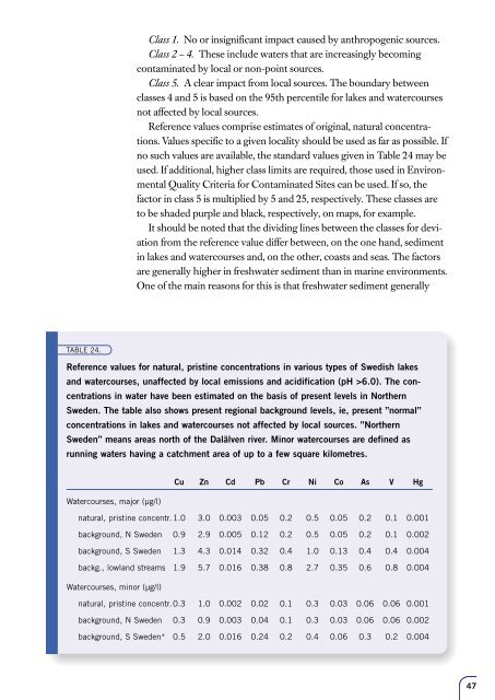
TABLE 24.<br />
Reference values for natural, pristine concentrations in various types of Swedish lakes<br />
<strong>and</strong> watercourses, unaffected by local emissions <strong>and</strong> acidification (pH >6.0). The concentrations<br />
in water have been estimated on the basis of present levels in Northern<br />
Sweden. The table also shows present regional background levels, ie, present ”normal”<br />
concentrations in lakes <strong>and</strong> watercourses not affected by local sources. ”Northern<br />
Sweden” means areas north of the Dalälven river. Minor watercourses are defined as<br />
running waters having a catchment area of up to a few square kilometres.<br />
Cu Zn Cd Pb Cr Ni Co As V Hg<br />
<strong>Watercourses</strong>, major (µg/l)<br />
natural, pristine concentr. 1.0 3.0 0.003 0.05 0.2 0.5 0.05 0.2 0.1 0.001<br />
background, N Sweden 0.9 2.9 0.005 0.12 0.2 0.5 0.05 0.2 0.1 0.002<br />
background, S Sweden 1.3 4.3 0.014 0.32 0.4 1.0 0.13 0.4 0.4 0.004<br />
backg., lowl<strong>and</strong> streams 1.9 5.7 0.016 0.38 0.8 2.7 0.35 0.6 0.8 0.004<br />
<strong>Watercourses</strong>, minor (µg/l)<br />
natural, pristine concentr. 0.3 1.0 0.002 0.02 0.1 0.3 0.03 0.06 0.06 0.001<br />
background, N Sweden 0.3 0.9 0.003 0.04 0.1 0.3 0.03 0.06 0.06 0.002<br />
background, S Sweden* 0.5 2.0 0.016 0.24 0.2 0.4 0.06 0.3 0.2 0.004<br />
47


![Accommodation booking form [PDF]](https://img.yumpu.com/39471785/1/184x260/accommodation-booking-form-pdf.jpg?quality=85)