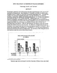
Vol. 54â2000 - NorthEastern Weed Science Society
Vol. 54â2000 - NorthEastern Weed Science Society
Vol. 54â2000 - NorthEastern Weed Science Society

Create successful ePaper yourself
Turn your PDF publications into a flip-book with our unique Google optimized e-Paper software.
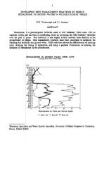
AUTOMATING MONITORING OF ROADSIDE WEEDS<br />
N.P. Cam', K. McKague\<br />
L. Kingston', and S. Struger'<br />
ABSTRACT<br />
An integrated system was evaluated for monitoring of roadside weed locations and related<br />
features, incorporating global positioning systems (GPS) for locating the sites in the field and<br />
geographic information systems (GIS) for storing, managing, manipulating and displaying the<br />
data. <strong>Weed</strong> areas, desirable vegetation, water features, culverts and sensitive adjacent land use<br />
were recorded. Methods of recording various roadside features as polygon, linear or point data<br />
were explored. Two systems of collecting the information were compared - a polygon, fieldbased<br />
collection system and a linear, vehicle-based collection system. Data collected can be used<br />
for planning of roadside vegetation management operations, contract management, quality<br />
control, and for communication of vegetation features to staff involved in planning, design and<br />
construction.<br />
'Cain Vegetation Inc., 5 Kingham Road, Acton, ON L7J 1S3<br />
'Ecologistics Limited, 490 Dutton Drive, Suite A-I, Waterloo, ON N2L 6H7; current address:<br />
Ontario Ministry of Agriculture and Rural Affairs, 1 Stone Road W., 3rd Floor, Guelph, ON,<br />
NIG4Y2<br />
'Roadside Vegetation Management Section and Geomatics Office, respectively; Ontario Ministry<br />
of Transportation, 301 St. Paul Street, St.Catharines, ON, L2R 7R4<br />
75