ICELANDIC TIMES - Land og saga
ICELANDIC TIMES - Land og saga
ICELANDIC TIMES - Land og saga

You also want an ePaper? Increase the reach of your titles
YUMPU automatically turns print PDFs into web optimized ePapers that Google loves.
Life Goes on Around Eyjafjallajökull<br />
„The people in the district are learning to live with the plume of ash hovering above them.“<br />
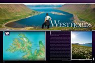
Iceland has been quite prominent<br />
in the world media these last<br />
months because of an eruption<br />
in the volcano Eyjafjallajökull,<br />
the ash emitted from the volcano<br />
causing immense flight delays<br />
in Europe. Although the volcano<br />
caused a lot of damage for the<br />
farmers in the area because<br />
of floods and ash fallout, life<br />
goes on in the region while the<br />
volcano continues to be active.<br />
Eyjafjallajökull is located in the<br />
district of East Rangárþing, which<br />
has a great number of natural<br />
treasures. These days the most<br />
interesting place to visit in Iceland<br />
is undoubtedly Rangárþing as you<br />
are able to see a volcano in action<br />
and also experience all the other<br />
treasures of the region.<br />
Eventful weeks after the<br />
eruption<br />
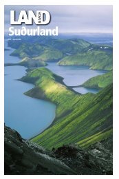
East Rangárþing is a vast district in<br />
the South of Iceland, which ranges<br />
from the highlands to the sea. It has a<br />
great number of geol<strong>og</strong>ical wonders,<br />
a fact which has pushed the district,<br />
according to Þuríður Halldóra<br />
Aradóttir, the district’s representative<br />
for public relations, to seek to<br />
become a member of the European<br />
Geopark Network along with two<br />
other districts; Mýrdalshreppur and<br />
Kirkjubæjarklaustur. Hvolsvöllur<br />
is the region’s biggest town and all<br />
operations relating to the eruption<br />
have been organized from there.<br />
The main industries in the area<br />
are agriculture and tourism and<br />
Hvolsvöllur is in fact the only town<br />
in Iceland which has not been<br />
established by the sea or a river, but<br />
entirely as a center of service for the<br />
area.<br />
“We Icelanders have, of course,<br />
grown up living in a volcanically<br />
active country so one could say it<br />
was in our blood to deal with this<br />
strong force and therefore we have<br />
a great civil defense operation for<br />
that purpose,” says Þuríður. “As soon<br />
as a lot of earthquakes began to be<br />
detected around the volcano, an<br />
operation was set into motion to<br />
„The surreal thing about all this is the fact that the damage caused was<br />
much more in Europe than here.“<br />
monitor Eyjafjallajökull and prepare<br />
to the utmost for a possible eruption.<br />
“The most dangerous issue concerning<br />
an eruption like this is perhaps in<br />
relation to the floods. Fortunately, our<br />
levees have been proven to be efficient.<br />
It has actually been said that they<br />
could hold four times more water than<br />
originally was believed. In fact, we are<br />
celebrating the levees’ centennial, as<br />
it’s a hundred years ago this year since<br />
the farmers started to load the original<br />
part of those we have today, using only<br />
wheelbarrows to transfer the gravel,”<br />
says Þuríður.<br />
According to Þuríður, people in the<br />
areas closest to the volcano were<br />
well informed about the clearance<br />
procedure. Because of the good cooperation<br />
between the inhabitants,<br />
rescue teams and local authorities,<br />
everything has been going according<br />
to plan. Right now, there is a great<br />
magnitude of water in the river<br />
Markarfljót which runs from under<br />
the glacier, although it is mainly caused<br />
by the yearly spring thaw.<br />
“The eruption and the tremendous<br />
ash fall in the first days was of course<br />
a horrible experience, especially for<br />
the farmers. But right now, the ash has<br />
become more or less harmless. Most<br />
of the farmers will be able to make hay<br />
this summer, but those who live next<br />
to the volcano will need to till their<br />
fields next summer and make use of<br />
the ash as a fertilizer. Right now, we are<br />
working on finding enough hay and<br />
fields for those farmers, so they can<br />
continue their farming successfully,”<br />
says Þuríður.<br />
Most of the animals remained in the<br />
area, although some horses, which<br />
were grazing near the volcano, were<br />
moved away. “We still had some horses<br />
outdoors when the ash fall was at its<br />
maximum, but it has not caused them<br />
any damage. The vets are amazed by<br />
how well they are holding out,” says<br />
Hildur.<br />
Many volunteers have been helping<br />
with the cleansing of the farms that<br />
were hit worst by the ash fall. “We’ve<br />
been getting more than enough help<br />
from people from all over the country.<br />
The houses and the roofs need to be<br />
cleaned as well as the surrounding<br />
area. The cleaning is still ongoing, but<br />
right now it’s at a temporary standstill<br />
as we’ve just been hit with a new wave<br />
of ashfall.”<br />
Misguiding media coverage<br />
It seems that people outside of Iceland<br />
have been receiving a rather misguiding<br />
image of what is actually going on as<br />
the coverage has been rather dramatic<br />
on the whole, suggesting that it is<br />
actually dangerous to be anywhere in<br />
Iceland. That is not the case as Þuríður<br />
explains: “The surreal thing about all<br />
this is the fact that the damage caused<br />
was much more in Europe than here,<br />
because of all the flight delays. The<br />
only restricted area or danger area<br />
right now is the Eyjafjallajökull glacier<br />
itself. Mýrdalsjökull, which is just east<br />
of Eyjafjallajökull, is open and people<br />
are going there on jeep excursions.<br />
“I think, in fact, that this eruption created<br />
more possibilities than hindrances for<br />
those wanting to experience Iceland. It<br />
is a very special opportunity to get to<br />
experience a volcanic eruption and yet<br />
be completely safe at the same time.”<br />
People have also been concerned<br />
that Katla, the volcano situated in<br />
Mýrdalsjökull, would follow this<br />
eruption. “They have been speculating<br />
about an eruption in Katla since I was<br />
a little girl, but you can’t stop living<br />
because of mere speculations,” says<br />
Þuríður. According to scientists, this<br />
eruption in Eyjafjallajökull is like an<br />
average eruption in Katla. Furthermore,<br />
there is nothing that suggests Katla is<br />
going to erupt any time soon, with no<br />
earthquakes under the glacier.<br />
Travelers always need to be careful<br />
when they travel around Iceland,<br />
though, especially in the higlands. A big<br />
information center has been opened<br />
in Hvolsvöllur, where tourists can get<br />
all the necessary information about<br />
the volcano, where in the highlands it<br />
is safe to go and where it is not, both<br />
concerning hiking and driving and<br />
where to get the service needed. The<br />
information center is right by the<br />
highway when entering the town from<br />
the direction of Reykjavík.<br />
Various opportunities<br />
The volcano is nevertheless not the<br />
only sight to see in East Rangárþing.<br />
The district contains many natural<br />
treasures as well as being the scene of<br />
one of the renowned Icelandic Sagas,<br />
the Saga of the burning of Njáll.<br />
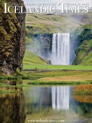
Some of the more famous places<br />
are for example Skógar, with its<br />
amazingly picturesque Skógarfoss<br />
waterfall; Seljalandsfoss waterfall,<br />
behind which it is possible to walk;<br />
and the Þórsmörk, which is a beautiful<br />
and fertile mountain ridge north of<br />
Eyjafjallajökull with various trekking<br />
routes in the area and so is very<br />
popular among hikers. “Then we also<br />
have less known natural wonders, like<br />
an abundance of caves, some of which<br />
have been made into outhouses with<br />
man-made extensions. We also have<br />
this great ring of mountains and if you<br />
drive around it you will find plenty of<br />
waterfalls,” Þuríður explains.<br />
A new harbour will be taken into use<br />
this summer called <strong>Land</strong>eyjarhöfn, in<br />
a distance of only 30 minutes from<br />
Hvolsvöllur. There you will get to the<br />
Westmanna Islands in half an hour,<br />
which is a new and quicker way to<br />
reach the islands. “You can also go see<br />
the vast, black coast there, it is quite<br />
amazing,” says Þuríður.<br />
There are plenty of options for<br />
accommodation in the area, ranging<br />
from camp-sites and hostels to high<br />
budget possibilities and then you<br />
will also find plenty of farmhouse<br />
accommodation in the area. “ says<br />
Þuríður.<br />
The people of East Rangárþing<br />
have gone through a lot lately, the<br />
ash fallout and floods causing a lot<br />
of extra work to be done as well as<br />
general uncertainties.<br />
Despite everything, daily life goes on<br />
and at this moment the people in the<br />
district are learning to live with the<br />
plume of ash hovering above them,<br />
being constantly a part of the horizon.<br />
In all other ways, people continue<br />
doing whatever they were doing<br />
before. But to witness the geol<strong>og</strong>ical<br />
wonders as well as hearing people’s<br />
stories about the eruption, ash and<br />
floods, is a treasure for anyone<br />
yearning to take in new experiences,<br />
culture and nature.<br />
60 61