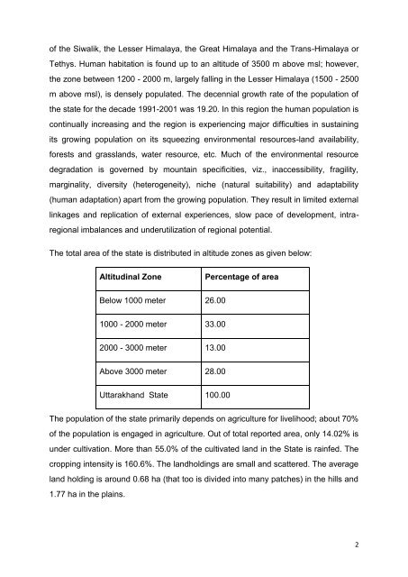
- Page 1 and 2: Uttarakhand State Perspective and S
- Page 3 and 4: Chapter-3 - Status of Rainfed Areas
- Page 5 and 6: UTTARAKHAND STATE PERSPECTIVE AND S
- Page 7 and 8: 2. Enhancing Livelihood Opportuniti
- Page 9 and 10: LIST OF ABBREVIATIONS AWP APMC BPL
- Page 11: CHAPTER 1 INTRODUCTION Uttarakhand
- Page 15 and 16: 1. Participatory Watershed Developm
- Page 17 and 18: ii. Almora iii. Pithoragarh iv. Cha
- Page 19 and 20: iv. Trans-Himalayas: Also known as
- Page 21 and 22: LAND USE Like most other hill econo
- Page 23 and 24: kharak and Satopanth glaciers. The
- Page 25 and 26: 5 Tehri 134 4,14,588 6 Rudraprayag
- Page 27 and 28: IRRIGATION STATUS As mentioned earl
- Page 29 and 30: AGRICULTURAL GROWTH AND DEVELOPMENT
- Page 31 and 32: As per (Annexure Table 2.8) the cro
- Page 33 and 34: Herbal and Medicinal plants : Uttar
- Page 35 and 36: Major forest types occurring in the
- Page 37 and 38: alance study has been conducted in
- Page 39 and 40: Uttarakhand. The Company targets a
- Page 41 and 42: Payment for ecosystem services: The
- Page 43 and 44: consumption. Sheep are held in larg
- Page 45 and 46: Natural lakes: Uttarakhand is havin
- Page 47 and 48: selling of agricultural produce and
- Page 49 and 50: Micro Credit : The State of Uttarak
- Page 51 and 52: Champawat, Dehradun, Pauri Garhwal,
- Page 53 and 54: The district which are having high
- Page 55 and 56: Uttarakhand has about 13 percent of
- Page 57 and 58: star if developed. The Delhi market
- Page 59 and 60: Weakness: Lack of sub-reg
- Page 61 and 62: products can be prepared from these
- Page 63 and 64:
4. Irrigation facilities are poor -
- Page 65 and 66:
ANALYSIS OF ISSUES IN LIVESTOCK MAN
- Page 67 and 68:
The forests cover 63.44 percent of
- Page 69 and 70:
parts of the state. So there is a n
- Page 71 and 72:
staples. Traditionally in the Himal
- Page 73 and 74:
culture of carps in the plain distr
- Page 75 and 76:
Cooperatives: The objective of orga
- Page 77 and 78:
Rating of SHGs is an important requ
- Page 79 and 80:
For planning of marketing strategie
- Page 81 and 82:
Exhibit-3-VI- Focus issues in Agri
- Page 83 and 84:
7. Developing of farm equipment /ma
- Page 85 and 86:
Exhibit 3-VII Agriculture Extension
- Page 87 and 88:
Even though such an infrastructure
- Page 89 and 90:
The maintenance of roads as per the
- Page 91 and 92:
the agricultural sector. Profession
- Page 93 and 94:
CHAPTER - 4 MAJOR PROGRAMS / SCHEME
- Page 95 and 96:
watershed basis are being sanctione
- Page 97 and 98:
ANALYSIS OF VARIOUS PROGRAMS/ SCHEM
- Page 99 and 100:
people. Not all focus group members
- Page 101 and 102:
The overall aims and objectives of
- Page 103 and 104:
Project objective of regenerating e
- Page 105 and 106:
conservation. Similarly, analysis o
- Page 107 and 108:
5. The number of people provided la
- Page 109 and 110:
CHAPTER - 5 ISSUES AND CHALLENGES T
- Page 111 and 112:
Thus the main issues which need to
- Page 113 and 114:
possible impacts on natural resourc
- Page 115 and 116:
The fact is that the fodder crisis
- Page 117 and 118:
already constrained due to mountain
- Page 119 and 120:
strategies has to be shifted toward
- Page 121 and 122:
CHAPTER - 6 VISION AND MISSION Utta
- Page 123 and 124:
CHAPTER -7 PERSPECTIVE NEED FOR PER
- Page 125 and 126:
Out of the 537 untreated MWS, 409 m
- Page 127 and 128:
financial autonomy in implementing
- Page 129 and 130:
Drainage line treatment is essentia
- Page 131 and 132:
Integrated pest & disease managemen
- Page 133 and 134:
If reduces the application of pesti
- Page 135 and 136:
source of the people. The project h
- Page 137 and 138:
stall-fed goats consume any fodder,
- Page 139 and 140:
opportunities for vulnerable famili
- Page 141 and 142:
encouraged, enabled and augmented w
- Page 143 and 144:
holder of the community. The follow
- Page 145 and 146:
Step Activity Purpose Finding an o
- Page 147 and 148:
(Table 7- g) - MITIGATION MEASURES
- Page 149 and 150:
AGRICULTURE 1. High Yielding Variet
- Page 151 and 152:
HORTICULTURE 1. Fruit Crops 2. Medi
- Page 153:
Social Mobilization / Formation of
- Page 157 and 158:
The SLNA consists of one representa
- Page 159 and 160:
The arrangements for setting up/ st
- Page 161 and 162:
Should be a registered legal entity
- Page 163 and 164:
Roles and responsibilities of WDT:
- Page 165 and 166:
Signing the cheques jointly with th
- Page 167 and 168:
S. No. 4. Van Panchayat Institution
- Page 169 and 170:
S. No. Institution Composition Role
- Page 171 and 172:
Garhwal University; Kumaon Universi
- Page 173 and 174:
IV Development of Village Watershed
- Page 175 and 176:
The WC shall make sure that the GPW
- Page 177 and 178:
Income generating activities for vu
- Page 179 and 180:
Take stock of the needs of the comm
- Page 181 and 182:
‣ Quality and marketability of th
- Page 183 and 184:
XV Review and appraisal of GPWDP: W
- Page 185 and 186:
Reimbursement of Cost of Works: Dur
- Page 187 and 188:
‣ In case of special technical re
- Page 189 and 190:
Particulars (Table 8-e.)- Fund flow
- Page 191 and 192:
Target Group Transhumant communitie
- Page 193 and 194:
CHAPTER -9 OUTPUT AND OUTCOME INDIC
- Page 195 and 196:
Objective Outcome Indicators Use of
- Page 197 and 198:
Target Values Target Values Outcome
- Page 199 and 200:
Target Values Target Values Outcome
- Page 201 and 202:
189
- Page 203 and 204:
Annexure Table 2.1: General Informa
- Page 205 and 206:
Annexure Table 2.3: Normal rainfall
- Page 207 and 208:
Annexure Table 2.5: Extent of Soil
- Page 209 and 210:
Annexure Table 2.7: Source wise Inc
- Page 211 and 212:
Annexure Table 2.9: Land holdings (
- Page 213 and 214:
Annexure Table 2.11: Area, Producti
- Page 215 and 216:
Sl.no Districts Crops Area (ha.) Pr
- Page 217 and 218:
Annexure Table 2.14: Source wise Ar
- Page 219 and 220:
Annexure Table 2.15 (b): Details of
- Page 221 and 222:
Annexure Table 2.17: Milk Populatio
- Page 223 and 224:
Annexure Table 2.19: Detials of Cre
- Page 225 and 226:
Annexure Table 2.21: Basic Marketin
- Page 227 and 228:
Annexure Table 4.1: Watershed Devel
- Page 229 and 230:
Table 8.1: Agro-Climatic zone wise
- Page 231 and 232:
Table 8.2(b): Annual Plan /Cost Tab
- Page 233 and 234:
Sl.no District Annexure Table 8.3:
- Page 235 and 236:
Criteria for exclusion of sub-proje
- Page 237 and 238:
ENVIRONMENTAL AND SOCIAL ASSESSMENT
- Page 239 and 240:
Sl. No 30 Project activities Small
- Page 241 and 242:
APPENDIX -4 Format for Gram panchay
- Page 243 and 244:
FORMAT FOR PREPARATION OF ESTIMATES
- Page 247 and 248:
MWS of Almora district with its wei
- Page 249 and 250:
MWS of Chamoli district with its we
- Page 251 and 252:
MWS of Champawat district with its
- Page 253 and 254:
MWS of Nainital district with its w
- Page 255 and 256:
Sl. No. DISTRI CT SWS MWS Clust App
- Page 257 and 258:
MWS of Pithoragarh district with it
- Page 259 and 260:
MWS of Tehri Garhwal district with
- Page 261 and 262:
MWS of Udham Singh Nagar district w
- Page 263 and 264:
Sl. No. DISTRICT SWS MWS Clust Appr
- Page 265:
LIST OF MAPS MAP-1- Map showing Dis
- Page 288:
WATERSHED MANAGEMENT DIRECTORATE UT