

2008 Annual Monitoring Report (pdf 10.9MB) - Bolsa Chica ...
2008 Annual Monitoring Report (pdf 10.9MB) - Bolsa Chica ...
2008 Annual Monitoring Report (pdf 10.9MB) - Bolsa Chica ...

You also want an ePaper? Increase the reach of your titles
YUMPU automatically turns print PDFs into web optimized ePapers that Google loves.
<strong>Bolsa</strong> <strong>Chica</strong> Lowlands Restoration <strong>Monitoring</strong><br />
<strong>2008</strong> <strong>Annual</strong> <strong>Report</strong><br />
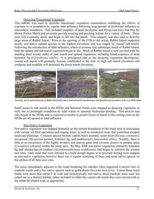
Decaying/Transitional Vegetation<br />
This habitat was used to describe transitional vegetation communities exhibiting the effects of<br />
exposure to or inundation by regular tidal influence following long periods of freshwater influence or<br />
intermittent inundation. This included rampikes of dead eucalyptus and Myoporum trees that ring the<br />
Muted Pocket Marsh and presently provide roosting and perching habitat for a variety of birds. These<br />
trees will eventually decay and begin to fall into the marsh. This category was also used to describe<br />
large areas of Rabbit Island. Prior to the opening of the FTB to the ocean, Rabbit Island supported<br />
mostly non-native upland species at the highest elevations and was ringed by coastal salt marsh.<br />
Following the introduction of tidal influence, which at extreme tide submerges much of Rabbit Island,<br />
both the upland and salt marsh vegetation began to die. Much of Rabbit Island is now covered with the<br />
standing dead woody stalks of past marsh and upland vegetation, including broad expanses of dead<br />
hottentot fig (Carpobrotus edulis). It is anticipated that as the decaying vegetation decomposes,<br />
coastal salt marsh will gradually become established at the mid- to high salt marsh elevations and<br />
cordgrass and mudflats will dominate the lower marsh elevations.<br />
Decaying marsh and hottentot fig on Rabbit Island (left/center), dead salt marsh transitioning to mud flat following inundation of the west MTB (right).<br />
Small losses to salt marsh in the MTBs and Seasonal Ponds were mapped as decaying vegetation as<br />
well, due to prolonged inundation by tidal waters or seasonal freshwater ponding. This process had<br />
only begun in the MTBs and is expected to results in greater losses of marsh in the coming years as the<br />
MTBs are all opened to tidal influence.<br />
Non-Native Vegetation<br />
Non-native vegetation was mapped primarily on the eastern boundaries of the study area in association<br />
with various oil filed operations and staging areas, as well as residential areas that contribute escaped<br />
landscape plantings. Common species include: radish, black mustard, castor-bean (Ricinus communis),<br />
myoporum (Myoporum laetum), hottentot fig, and tumbleweed (Amaranthus albus). Notably, there is<br />
little to no occurrence of the highly invasive non-natives giant reed (Arundo donax) or pampas grass<br />
(Cortaderia selloana) within the study area. By May <strong>2008</strong> non-native vegetation, primarily hottentot<br />
fig and slender-leaved iceplant (Mesembryanthemum nodiflorum), had begun to colonize the created<br />
nest sites. Only areas that were infested to a high enough degree as to preclude nesting were mapped<br />
as non-native vegetation, however there was a regular scattering of these and some native species on<br />
the surface of all three nest sites.<br />
The areas immediately adjacent to the roads bordering the marshes often supported a narrow mix of<br />
roadside weeds and a few native species such as goldenbush (Isocoma menziesii). Unless these weed<br />
bands were more than about 3 m wide and monotypically non-native, these roadside areas were not<br />
called out as a distinct habitat, rather included in either the coastal salt marsh they were mixed with or<br />
the urban/developed road, as appropriate.<br />
Merkel & Associates, Inc. 27


