2008 Annual Monitoring Report (pdf 10.9MB) - Bolsa Chica ...
2008 Annual Monitoring Report (pdf 10.9MB) - Bolsa Chica ... 2008 Annual Monitoring Report (pdf 10.9MB) - Bolsa Chica ...
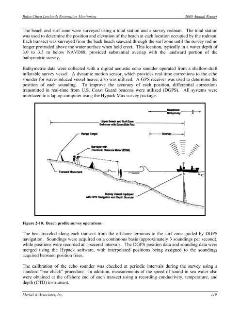
Bolsa Chica Lowlands Restoration Monitoring 2008 Annual Report The beach and surf zone were surveyed using a total station and a survey rodman. The total station was used to determine the position and elevation of the beach at each location occupied by the rodman. Each transect was surveyed from the back beach seaward through the surf zone until the survey rod no longer protruded above the water surface when held erect. This location, typically in a water depth of 3.0 to 3.5 m below NAVD88, provided substantial overlap with the landward portion of the bathymetric survey. Bathymetric data were collected with a digital acoustic echo sounder operated from a shallow-draft inflatable survey vessel. A dynamic motion sensor, which provides real-time corrections to the echo sounder for wave-induced vessel heave, also was utilized. A GPS receiver was used to determine the position of each sounding. To improve the accuracy of each position, differential corrections transmitted in real-time from U.S. Coast Guard beacons were utilized (DGPS). All systems were interfaced to a laptop computer using the Hypack Max survey package. Figure 2-10. Beach profile survey operations The boat traveled along each transect from the offshore terminus to the surf zone guided by DGPS navigation. Soundings were acquired on a continuous basis (approximately 3 soundings per second), while positions were recorded at 1-second intervals. The DGPS position data and sounding data were merged using the Hypack software, with interpolated positions being assigned to the soundings acquired between position fixes. The calibration of the echo sounder was checked at periodic intervals during the survey using a standard “bar check” procedure. In addition, measurements of the speed of sound in sea water also were obtained at the offshore end of each transect using a recording conductivity, temperature, and depth (CTD) instrument. Merkel & Associates, Inc. 119
Bolsa Chica Lowlands Restoration Monitoring 2008 Annual Report The data from the wading portion of each survey were processed using software developed by Trimble. The software read the raw total station data, and the coordinates and elevation of each data point were calculated and inserted into a CAD drawing. The raw data from the bathymetric portion of each survey consisted of Hypack files containing the position data and heave-compensated soundings. These data were edited for outliers using the Hypack Single-Beam Processing Module. The dynamic motion sensor utilized during the survey removed the majority of the wave contamination from the record in real time. To further minimize the influence of wave-induced vessel motion on several transects, however, a smooth line was faired through the echo sounder record prior to digitizing it with the Hypack software package. Corrections for the draft of the transducer and the measured speed of sound in sea water then were applied to the measured depths. The speed-of-sound profiles were confirmed using the results of the “bar check” calibration procedure. Finally, the corrected soundings were adjusted to NAVD88 datum using tide measurements made by the U.S. Department of Commerce, NOAA, at Los Angeles Harbor. To provide a more accurate representation of local tide conditions, the water levels recorded at Los Angeles Harbor were adjusted to the project site using the time and height differences published by NOAA (NOS, 2008). The adjusted soundings were thinned to a nominal horizontal interval of 3 m to produce a file size suitable for developing beach profile plots. The resulting x, y, z data (easting, northing, and elevation) were inserted into the CAD drawing containing the wading data. As indicated above, the fieldwork was conducted in such a manner as to provide substantial overlap between the wading and bathymetric portions of the survey. The processed data were examined in this region to insure that the two data sets were compatible. Once this confirmatory inspection had been completed, only the more detailed data in the region of overlap were retained (typically the bathymetric data). The less detailed data were purged, after which the wading and bathymetric data were merged to create a single digital file. Based on past experience, the vertical accuracy of the processed soundings is approximately ±15 cm. According to the Hemisphere GPS equipment specifications, the accuracy of horizontal positions obtained in the manner described above is less than 1.0 m. The electronic total station used to conduct the survey is capable of measuring ranges to within ±15 cm and elevation differences to within ±3 cm. Because the swimmer encountered waves and currents in the surf zone, however, the horizontal accuracy perpendicular to each transect (parallel to the shoreline) varied from minimal at short ranges to approximately ±5 m at the offshore end. Beach Width Measurement Program Monthly beach width measurements were acquired at each of the seven profile sites, commencing in January 2007 and continuing throughout 2008. The measurements were collected at tide heights ranging from -0.62 m to 1.96 m, NAVD. The beach width was recorded as the distance from a permanent point at the back beach to the approximate intersection of the still water line and the beach face. The foreshore slope also was measured and recorded along with the date and time of the observation. The measurements then were adjusted to approximate the MSL beach width using the foreshore slope and NOAA tide elevations. In addition, the distance from the back beach to the berm was measured. Although inherently less accurate than Merkel & Associates, Inc. 120
- Page 74 and 75: 22 Temperature 20 Temperature (C) 1
- Page 76 and 77: Bolsa Chica Lowlands Restoration Mo
- Page 78 and 79: PM 50 66 47 Full Tidal Basin Future
- Page 80 and 81: Bolsa Chica Lowlands Restoration Mo
- Page 82 and 83: Bolsa Chica Lowlands Restoration Mo
- Page 84 and 85: Bolsa Chica Lowlands Restoration Mo
- Page 86 and 87: Bolsa Chica Lowlands Restoration Mo
- Page 88 and 89: Bolsa Chica Lowlands Restoration Mo
- Page 90 and 91: Bolsa Chica Lowlands Restoration Mo
- Page 92 and 93: Bolsa Chica Lowlands Restoration Mo
- Page 94 and 95: Zone PM 2 9 10 11 12 13 14 19 20 21
- Page 96 and 97: Bolsa Chica Lowlands Restoration Mo
- Page 98 and 99: Bolsa Chica Lowlands Restoration Mo
- Page 100 and 101: Bolsa Chica Lowlands Restoration Mo
- Page 102 and 103: Bolsa Chica Lowlands Restoration Mo
- Page 104 and 105: Bolsa Chica Lowlands Restoration Mo
- Page 106 and 107: Bolsa Chica Lowlands Restoration Mo
- Page 108 and 109: Aug06 to Jan07 Jan07 to Jun07 assum
- Page 110 and 111: Bolsa Chica Lowlands Restoration Mo
- Page 112 and 113: Bolsa Chica Lowlands Restoration Mo
- Page 114 and 115: Bolsa Chica Lowlands Restoration Mo
- Page 116 and 117: Bolsa Chica Lowlands Restoration Mo
- Page 118 and 119: Bolsa Chica Lowlands Restoration Mo
- Page 120 and 121: Bolsa Chica Lowlands Restoration Mo
- Page 122 and 123: Bolsa Chica Lowlands Restoration Mo
- Page 126 and 127: Bolsa Chica Lowlands Restoration Mo
- Page 128 and 129: Bolsa Chica Lowlands Restoration Mo
- Page 130 and 131: Bolsa Chica Lowlands Restoration Mo
- Page 132 and 133: Bolsa Chica Lowlands Restoration Mo
- Page 134 and 135: Bolsa Chica Lowlands Restoration Mo
- Page 136 and 137: Bolsa Chica Lowlands Restoration Mo
- Page 138 and 139: Bolsa Chica Lowlands Restoration Mo
- Page 140 and 141: Bolsa Chica Lowlands Restoration Mo
- Page 142 and 143: Bolsa Chica Lowlands Restoration Mo
- Page 144 and 145: Bolsa Chica Lowlands Restoration Mo
- Page 146 and 147: Bolsa Chica Lowlands Restoration Mo
- Page 148 and 149: Bolsa Chica Lowlands Restoration Mo
- Page 150 and 151: Bolsa Chica Lowlands Restoration Mo
- Page 152 and 153: Bolsa Chica Lowlands Restoration Mo
- Page 154 and 155: Bolsa Chica Lowlands Restoration Mo
- Page 156 and 157: Bolsa Chica Lowlands Restoration Mo
- Page 158 and 159: Bolsa Chica Lowlands Restoration Mo
- Page 160 and 161: Bolsa Chica Lowlands Restoration Mo
- Page 162 and 163: Bolsa Chica Lowlands Restoration Mo
- Page 164 and 165: Bolsa Chica Lowlands Restoration Mo
- Page 166 and 167: Bolsa Chica Lowlands Restoration Mo
- Page 168 and 169: Total Future Full Tidal Basin FFTB
- Page 170 and 171: Bolsa Chica Lowlands Restoration Mo
- Page 172 and 173: Western Snowy Plover Nesting at Bol
<strong>Bolsa</strong> <strong>Chica</strong> Lowlands Restoration <strong>Monitoring</strong><br />
<strong>2008</strong> <strong>Annual</strong> <strong>Report</strong><br />
The beach and surf zone were surveyed using a total station and a survey rodman. The total station<br />
was used to determine the position and elevation of the beach at each location occupied by the rodman.<br />
Each transect was surveyed from the back beach seaward through the surf zone until the survey rod no<br />
longer protruded above the water surface when held erect. This location, typically in a water depth of<br />
3.0 to 3.5 m below NAVD88, provided substantial overlap with the landward portion of the<br />
bathymetric survey.<br />
Bathymetric data were collected with a digital acoustic echo sounder operated from a shallow-draft<br />
inflatable survey vessel. A dynamic motion sensor, which provides real-time corrections to the echo<br />
sounder for wave-induced vessel heave, also was utilized. A GPS receiver was used to determine the<br />
position of each sounding. To improve the accuracy of each position, differential corrections<br />
transmitted in real-time from U.S. Coast Guard beacons were utilized (DGPS). All systems were<br />
interfaced to a laptop computer using the Hypack Max survey package.<br />
Figure 2-10. Beach profile survey operations<br />
The boat traveled along each transect from the offshore terminus to the surf zone guided by DGPS<br />
navigation. Soundings were acquired on a continuous basis (approximately 3 soundings per second),<br />
while positions were recorded at 1-second intervals. The DGPS position data and sounding data were<br />
merged using the Hypack software, with interpolated positions being assigned to the soundings<br />
acquired between position fixes.<br />
The calibration of the echo sounder was checked at periodic intervals during the survey using a<br />
standard “bar check” procedure. In addition, measurements of the speed of sound in sea water also<br />
were obtained at the offshore end of each transect using a recording conductivity, temperature, and<br />
depth (CTD) instrument.<br />
Merkel & Associates, Inc. 119


