

Dufferin_Avenue_Study-Final_Report
Dufferin_Avenue_Study-Final_Report
Dufferin_Avenue_Study-Final_Report

Create successful ePaper yourself
Turn your PDF publications into a flip-book with our unique Google optimized e-Paper software.
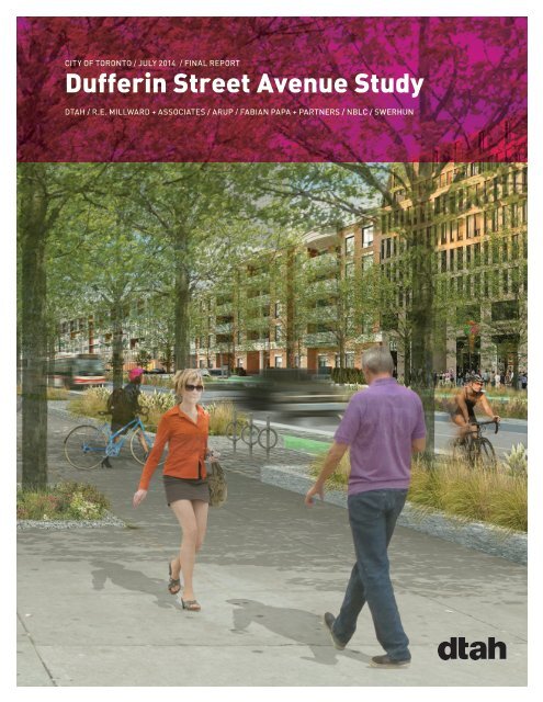
CITY OF TORONTO / JULY 2014 / FINAL REPORT<br />
<strong>Dufferin</strong> Street <strong>Avenue</strong> <strong>Study</strong><br />
DTAH / R.E. MILLWARD + ASSOCIATES / ARUP / FABIAN PAPA + PARTNERS / NBLC / SWERHUN
PROJECT CREDITS<br />
CITY OF TORONTO<br />
ANDRIA SALLESE, COLIN RAMDIAL, AL REZOSKI<br />
VICTORIA WITOWSKI, ANDREW AU, DEWAN KARIM<br />
LEO DESORCEY, DAWN HAMILTON, SASHA TERRY<br />
MARIO GIAMBATTISTA, LORA MAZZOCCA, BRIAN WORSLEY<br />
DTAH BRENT RAYMOND, ROBERT ALLSOPP, RENÉ BIBERSTEIN<br />
R.E. MILLWARD + ASSOCIATES LTD MELANIE MELNYK, ROBERT MILLWARD, JOHN BURKE<br />
ARUP CANADA HILARY HOLDEN, GARY HSEUH, AARSHABH MISRA, MARC-PAUL GAUTHIER<br />
FABIAN PAPA + PARTNERS FABIAN PAPA, JASON JENKINS<br />
N. BARRY LYON CONSULTING MARK CONWAY<br />
SWERHUN BIANCA WYLIE, NICOLE SWERHUN, YULIA PAK, ALEX HEATH
CITY OF TORONTO / JULY 2014 FINAL REPORT<br />
<strong>Dufferin</strong> Street <strong>Avenue</strong> <strong>Study</strong><br />
PREPARED FOR<br />
THE CITY OF TORONTO<br />
PREPARED BY<br />
DTAH PROJECT LEAD, URBAN DESIGN AND LANDSCAPE ARCHITECTURE<br />
R.E. MILLWARD + ASSOCIATES LTD. LAND USE PLANNING<br />
ARUP TRANSPORTATION<br />
FABIAN PAPA & PARTNERS SERVICING INFRASTRUCTURE<br />
N. BARRY LYON CONSULTING REAL ESTATE AND MARKETING<br />
SWERHUN ENGAGEMENT AND DECISION SUPPORT
CONTENTS<br />
Executive Summary<br />
I<br />
1. Introduction 1<br />
2. <strong>Study</strong> Process 3<br />
3. Policy Context 7<br />
3.1 Provincial Policy 7<br />
3.2 City Of Toronto Policy 7<br />
4. Existing Conditions 13<br />
4.1 Character 13<br />
4.2 Demographic Profile 16<br />
4.3 Parks And Open Spaces 17<br />
4.4 Community Services And Facilities (Cs&F) 18<br />
4.5 Transportation Infrastructure 19<br />
4.6 Servicing Infrastructure 26<br />
5. Guiding Principles 29<br />
6. Option Development And Evaluation 34<br />
7. Recommended Guidelines + Standards 36<br />
7.1 Introduction 36<br />
7.2 Planning And Design Framework Recommendations 37<br />
7.3 Specific Recommendations For The Typical <strong>Avenue</strong> Blocks 58<br />
7.4 Specific Recommendations For The Larger Blocks 61<br />
7.5 Mobility Strategies 74<br />
7.6 Sustainability 79<br />
8. Recommended Streetscape Improvements 81<br />
8.1 Planning And Policy Context 81<br />
8.2 Examination Of Right-Of-Way Expansion 82<br />
8.3 Recommended Streetscape Improvements 82<br />
9. Demonstration Plan 94<br />
10. Community Services & Facilities Strategy Summary 96<br />
11. Transportation Master Plan Summary 103<br />
12. Infrastructure Master Plan Summary 107<br />
13. Implementation 108<br />
13.1 Recommended Actions 108<br />
13.2 Directions For Future <strong>Study</strong> 113<br />
14. Conclusion 116<br />
Appendices 117<br />
Community Services And Facilities Strategy<br />
Community And Stakeholder Consultation Summaries
List of Figures<br />
Fig. 1. Aerial Photograph, Existing <strong>Study</strong> Area 2<br />
Fig. 2. <strong>Study</strong> Process 3<br />
Fig. 3. <strong>Dufferin</strong> Street in the Urban Structure Plan 7<br />
Fig. 4. Existing Consolidated Land Use Zones 9<br />
Fig. 5. Existing Consolidated Height Zones 11<br />
Fig. 6. Existing Land Use 13<br />
Fig. 7. Community Services and<br />
Facilities (CS&F) Areas 16<br />
Fig. 8. Existing Parks and Publicly<br />
Accessible Open Spaces 17<br />
Fig. 9. Existing Vehicular Network 20<br />
Fig. 10. Existing Pedestrian Network 22<br />
Fig. 11. Planned Cycling Network - Wider Context 24<br />
Fig. 12. Existing Transit Network - Wider Context 25<br />
Fig. 13. Existing Servicing Infrastructure 26<br />
Fig. 14. Process for Testing and Confirming Ideas<br />
to Define the Preferred Option 35<br />
Fig. 15. Structure Plan 37<br />
Fig. 16. Streets and Blocks Framework Plan 38<br />
Fig. 17. Parks and Open Space Framework Plan 43<br />
Fig. 18. Grade Related Uses 45<br />
Fig. 19. Recommended Mandatory<br />
Minimum Setbacks 48<br />
Fig. 20. Angular Planes Applied<br />
Across <strong>Dufferin</strong> Street 50<br />
Fig. 21. Special Angular Planes in<br />
Blocks 6, 7 and 8 50<br />
Fig. 22. Transition from adjacent Neighbourhood<br />
Special Angular Planes in Block 1 51<br />
Fig. 23. Transition from Employment Areas, Typical 51<br />
Fig. 24. Transition from Employment Areas,<br />
Blocks 1 and 8 51<br />
Fig. 26. Maximum Building Height<br />
(excluding Tall Buildings) 53<br />
Fig. 25. Permitted Locations for Tall Buildings 53<br />
Fig. 27. Recommended Maximum Densities 56<br />
Fig. 28. Typical <strong>Avenue</strong> Blocks in<br />
the <strong>Study</strong> Area (in orange) 58<br />
Fig. 29. Typical <strong>Avenue</strong> Blocks<br />
Demonstration Model View 59<br />
Fig. 30. Larger Blocks in the <strong>Study</strong> Area (in orange) 61<br />
Fig. 31. Block 1 - Demonstration Model View<br />
looking northwest 62<br />
Fig. 32. Block 6 - Demonstration Model View<br />
looking northwest, illustrating mid-rise<br />
development throughout. 64<br />
Fig. 33. Block 7 - Demonstration Model View<br />
looking northwest, illustrating mid-rise towards<br />
<strong>Dufferin</strong> and townhouse buildings to the west of the block 66<br />
Fig. 34. Block 8 - Demonstration Model View 68<br />
Fig. 35. Block 14 - Demonstration Model View 71<br />
Fig. 36. Recommended Vehicular Strategy 75<br />
Fig. 37. Recommended Transit Strategy 76<br />
Fig. 38. Recommended Pedestrian Strategy 77<br />
Fig. 39. Recommended Cycling Strategy 78<br />
Fig. 41. <strong>Dufferin</strong> Streetscape - Existing Condition<br />
Typical Section 84<br />
Fig. 42. <strong>Dufferin</strong> Streetscape -<br />
Recommended Improvements Typical Section 85<br />
Fig. 43. <strong>Dufferin</strong> Streetscape -<br />
Green Setback, Typical Section<br />
Residential Frontage at Grade Typical Section 85<br />
Fig. 44. <strong>Dufferin</strong> Streetscape -<br />
Green Setback, Typical Section<br />
Retail Frontage at Grade 85<br />
Fig. 45. <strong>Dufferin</strong> Streetscape - Typical Section<br />
Potential Short Term Improvements 90<br />
Fig. 46. Orfus Road Streetscape - Typical Section 91<br />
Fig. 47. Existing Local Street Streetscape - Typical Section<br />
New Local Street Streetscape - Typical Section (Option 1) 92<br />
Fig. 48. New Local Street Streetscape<br />
Typical Section (Option 2) 93<br />
Fig. 49. Regional travel patterns 103<br />
Fig. 50. Daily variation in northbound traffic<br />
on <strong>Dufferin</strong> Street (2012). 105<br />
Fig. 51. Daily variation in southbound traffic<br />
on <strong>Dufferin</strong> Street (2012). 105<br />
Fig. 52. Directions for Future <strong>Study</strong> 113
A VISION FOR DUFFERIN STREET<br />
The vision for <strong>Dufferin</strong> Street is the result of extensive<br />
public consultation and follows the policy direction<br />
for intensification along the <strong>Avenue</strong>s. New<br />
development in the form of mid-rise buildings will<br />
address <strong>Dufferin</strong> Street and frame the pedestrian<br />
realm. A new streetscape will transform this vehicledominated<br />
road into a place with large, healthy trees<br />
additional opportunities for greening, revitalized<br />
retail and residential uses, and generous space for<br />
pedestrians and cyclists.
EXECUTIVE SUMMARY<br />
BACKGROUND<br />
<strong>Study</strong> Area<br />
This <strong>Avenue</strong> <strong>Study</strong> includes <strong>Dufferin</strong> Street and all<br />
properties with a Mixed Use Official Plan designation<br />
fronting onto it, between Highway 401 and just south<br />
of Lawrence <strong>Avenue</strong> West. In the case of Yorkdale<br />
Shopping Centre and the southern corners of the<br />
intersection of <strong>Dufferin</strong> Street and Lawrence <strong>Avenue</strong><br />
West, only a part of the properties are included.<br />
Bounded by Neighbourhoods and Employment<br />
Areas, the <strong>Study</strong> Area consists mostly of commercial<br />
or mixed-use buildings, including a number of car<br />
dealerships, gas stations and strip malls.<br />
Lots on the west side of <strong>Dufferin</strong> Street are generally<br />
deep and wide, while those on the east side tend to<br />
be shallow and narrow.<br />
Purpose<br />
Recent redevelopment interest has challenged<br />
<strong>Dufferin</strong> Street’s built form and public realm<br />
character, both of which have changed little since the<br />
1960s.<br />
In response to this, the <strong>Avenue</strong> <strong>Study</strong> was<br />
commissioned by the City to examine mixed land<br />
use and built form potential, to develop a planning<br />
framework and make recommendations to implement<br />
the vision.<br />
This <strong>Avenue</strong> <strong>Study</strong> seeks to take advantage of this<br />
crucial opportunity to build a livable, attractive urban<br />
community on <strong>Dufferin</strong> Street.<br />
Create a Green, Safe<br />
and Attractive Place<br />
Improve Mobility and<br />
Balance Movement Priorities<br />
Create Quality<br />
Public Spaces<br />
and Parks<br />
<strong>Dufferin</strong> Respecting the Street<br />
Adjoining Neighbourhoods<br />
Guiding and Employment Principles<br />
Lands<br />
Improve Community Services<br />
and Facilities through<br />
Redevelopment<br />
Make <strong>Dufferin</strong> Street a Place<br />
Protect the<br />
Adjoining Neighbourhoods<br />
and Employment Lands<br />
Encourage a Rich and<br />
Varied Urban Built Form<br />
Integrate Land Use and<br />
Redevelopment with<br />
Supporting Infrastructure<br />
Redevelop with<br />
Appropriate Land Uses<br />
and Densities<br />
The vision for this segment of <strong>Dufferin</strong> Street is best summarized in the Guiding Principles, which<br />
were developed in consultation with the public and informed the process and recommendations.<br />
i<br />
DUFFERIN STREET AVENUE STUDY
STUDY PROCESS<br />
OPTIONS<br />
The overall project was conducted in four Phases:<br />
1. The first Phase was to introduce the project to<br />
the community, understand the local context and<br />
issues, and develop a vision for the <strong>Study</strong> Area.<br />
2. In the second Phase, a range of alternative<br />
options were explored.<br />
3. The third Phase was to test and confirm these<br />
options.<br />
4. In the fourth and final Phase, the input received<br />
through the entire process was synthesized.<br />
Community and Stakeholder Consultation<br />
Stakeholders and the community were involved in all<br />
Phases of the <strong>Avenue</strong> <strong>Study</strong> process, which included:<br />
• Four Local Advisory Committee meetings<br />
• Three public open houses<br />
• A community design charrette<br />
• Individual meetings with selected stakeholders<br />
• Two presentations to the Design Review Panel<br />
POLICY CONTEXT<br />
The <strong>Study</strong> Team considered a range of existing City<br />
and Provincial policy in making its recommendations.<br />
The City of Toronto Official Plan provides an Urban<br />
Structure, in which <strong>Dufferin</strong> Street is described as<br />
an <strong>Avenue</strong>. The lands within the <strong>Study</strong> Area are<br />
designated as Mixed Use Areas in its Land Use Plan.<br />
Zoning in the <strong>Study</strong> Area is split between the current<br />
Toronto and former North York bylaw regimes, with<br />
the latter covering Yorkdale Shopping Centre and the<br />
large lots on the west side of the street. The <strong>Study</strong><br />
Area is also governed by Schedule ‘D’ of North York<br />
Bylaw 7625, which limits height based on proximity to<br />
the Downsview Airport.<br />
Informed in part by the community design charrette,<br />
the <strong>Study</strong> Team first developed a general planning<br />
framework, which laid out a pattern of streets,<br />
blocks, and open spaces.<br />
Within that framework, five design options were<br />
explored. Each of the options was then demonstrated<br />
in a digital massing model, which was used to<br />
generate population estimates.<br />
All of the options were evaluated and compared<br />
using a comprehensive matrix of criteria that<br />
included land use, density, built form, transportation,<br />
servicing and impacts on the public realm. The<br />
preferred design was influenced by several of the<br />
options explored during the evaluation process, the<br />
project guiding principles, existing policy, the <strong>Study</strong><br />
Team’s professional expertise and community and<br />
stakeholder consultation.<br />
GUIDELINES AND STANDARDS<br />
The Recommended Guidelines and Standards are<br />
divided into two parts: those that apply to the entire<br />
<strong>Study</strong> Area, and those specific to particular blocks.<br />
They cover the following:<br />
Streets and Blocks<br />
The deep blocks within the <strong>Study</strong> Area should be<br />
subdivided by a network of new local streets to<br />
facilitate movement and accessibility. Those streets<br />
are identified as either Fixed or Flexible in location.<br />
Additionally, rear laneways are recommended for<br />
most of the shallow blocks.<br />
Parks and Open Spaces<br />
New parks should be included as part of future<br />
redevelopment of all the deep blocks in the <strong>Study</strong><br />
Area with the exception of Yorkdale Shopping Centre.<br />
The McAdam turning loop should be converted to a<br />
public park, and a landmark landscape gateway area<br />
should be constructed at Highway 401.<br />
ii<br />
DUFFERIN STREET AVENUE STUDY
Smaller privately-owned, publicly accessible urban<br />
plazas should be added at specific locations.<br />
Courtyard spaces are recommended, where feasible<br />
or desirable.<br />
Land Use<br />
Residential Mixed Use is promoted for the <strong>Study</strong><br />
Area, with the exception of Yorkdale Shopping<br />
Centre. This is expected to result in primarily<br />
residential development, with street-related retail at<br />
grade. However, retail at grade will only be mandatory<br />
at key nodes.<br />
Built Form<br />
Mid-rise built form is appropriate for all parts of<br />
the <strong>Study</strong> Area, with the exception of the Yorkdale<br />
Shopping Centre property. Tall buildings will be<br />
permitted at only two nodes: the northwest block at<br />
Highway 401, and on the northwest corner of <strong>Dufferin</strong><br />
Street and Lawrence <strong>Avenue</strong> West. They should be<br />
seen as forming gateways to the <strong>Study</strong> Area.<br />
Setbacks<br />
A system of mandatory setbacks is proposed<br />
for all blocks within the <strong>Study</strong> Area to permit<br />
wider sidewalks, retail amenity spaces, or green<br />
landscaping in front of ground-level residential uses.<br />
Angular Planes and Transition<br />
Angular planes will be applied to all sites within the<br />
<strong>Study</strong> Area, in keeping with the standards developed<br />
in the <strong>Avenue</strong>s and Mid-rise Buildings <strong>Study</strong> and<br />
Tall Building Guidelines. These will form a transition<br />
between existing Neighbourhoods and any new<br />
development. Angular planes will also be used to<br />
identify the locations where tall or mid-rise buildings<br />
will be located on particular blocks.<br />
A minimum separation distance of 20m will be<br />
applied between the Employment Areas and any new<br />
Residential uses.<br />
Height<br />
Height restrictions are informed by local context and<br />
policy direction for the <strong>Avenue</strong>s. Mid-rise buildings<br />
will be limited to a height equivalent to the width of<br />
the right-of-way onto which they front. That height<br />
may be further limited by angular planes (reflecting<br />
lot depth). Tall buildings will be limited in height<br />
by Schedule ‘D’ of North York Bylaw 7625, or any<br />
subsequent airport hazard area height regulations.<br />
Stepbacks<br />
A stepback will be required for all mid-rise buildings.<br />
This is intended to give a consistent appearance to<br />
the streetscape and allow for light penetration and<br />
sky views.<br />
Density<br />
An average gross density of 2.5 times site area<br />
is recommended for the <strong>Study</strong> Area, apportioned<br />
distinctly by block. This density target is an keeping<br />
with intensification corridors with similar conditions.<br />
Mobility<br />
The <strong>Study</strong> identifies a number of approaches for<br />
improving vehicle, transit, pedestrian and bicycle<br />
linkages including:<br />
• New public street connections and access lanes;<br />
• New signalized intersections;<br />
• A southbound transit priority lane, north of<br />
Cartwright <strong>Avenue</strong>; and<br />
• New cycle tracks, bike lanes and signed cycling<br />
routes.<br />
STREETSCAPE<br />
The <strong>Study</strong> Team developed recommended<br />
streetscape sections for <strong>Dufferin</strong> Street, new local<br />
side streets, and the segments of Orfus, Samor and<br />
Apex Roads within the <strong>Study</strong> Area. Without widening<br />
the right-of-way, all of these include a substantially<br />
improved pedestrian realm that features broader<br />
sidewalks, street tree plantings, a landscaped median<br />
and bicycle lanes where possible.<br />
iii<br />
DUFFERIN STREET AVENUE STUDY
COMMUNITY SERVICES AND<br />
FACILITIES STRATEGY<br />
The <strong>Study</strong> Team undertook a detailed survey of City<br />
Divisions and community agencies with follow-up<br />
interviews as necessary. Questionnaires were<br />
designed to seek input on priorities for improving<br />
existing and future community services and facilities<br />
to serve the <strong>Study</strong> Area.<br />
The findings recommend a number of specific<br />
improvements to be implemented as development<br />
proceeds, ensuring adequate Parks and Open<br />
Spaces, Community Recreation Centres,<br />
Libraries, Child Care, Schools, Human Services,<br />
and Community Agencies to serve the growing<br />
population. Ongoing monitoring of CS&F needs and<br />
priorities is also recommended.<br />
TRANSPORTATION MASTER PLAN<br />
INFRASTRUCTURE MASTER PLAN<br />
In order to enhance the performance of the City’s<br />
storm drainage infrastructure, particularly in light<br />
of the basement flooding concerns in and near<br />
the <strong>Study</strong> Area, the City’s Wet Weather Flow<br />
Management Guidelines (WWFMG) will be generally<br />
implemented for all developments, although the peak<br />
allowable release rate from each site will be reduced<br />
substantially from the WWFMG.<br />
In terms of sanitary sewer infrastructure, several<br />
upgrades have been identified which include<br />
in-line storage elements to attenuate peak wet<br />
weather flows, as well as increased pipe sizes in<br />
selected locations. It is noted that the existing water<br />
distribution system is sufficient to provide for future<br />
needs without upgrades.<br />
IMPLEMENTATION<br />
Informed by the problem statement and guiding<br />
principles, four Transportation Alternative Planning<br />
Solutions, differing in their components, were<br />
developed in response to the selection of the<br />
preferred design. They were evaluated in a matrix<br />
using a number of criteria.<br />
Ultimately, a solution that continues to utilize the 30m<br />
right-of-way and five lane cross-section was selected<br />
as the preferred choice. It converts the turning lane<br />
to a median in midblock areas. The median improves<br />
reliability by preventing disruptive left turns and<br />
u-turns, while greening the street. Other streetscape<br />
improvements include street trees, generous<br />
boulevards and cycling infrastructure.<br />
The following actions should be undertaken in order<br />
for this <strong>Avenue</strong> <strong>Study</strong>’s recommendations to be<br />
implemented:<br />
• Amend the Official Plan to create Site and Area-<br />
Specific Policies guiding future development for<br />
this portion of <strong>Dufferin</strong> Street.<br />
• Amend the former North York and current Toronto<br />
Zoning By-laws, including a consolidation of<br />
all properties into the current City-wide Zoning<br />
By-law.<br />
• Enable Holding (‘H’) provisions in the Site and<br />
Area Specific Policies and Site-Specific Zoning<br />
By-laws to ensure coordinated development and<br />
timely delivery of infrastructure.<br />
• Continue ongoing monitoring of community<br />
services and facilities needs, as development<br />
proceeds throughout the corridor.<br />
• Establish a phasing of streetscape improvements<br />
and a suggested phasing of block consolidation.<br />
iv<br />
DUFFERIN STREET AVENUE STUDY
HOW TO READ THIS REPORT<br />
This report loosely follows the chronological format<br />
that the <strong>Study</strong> itself took, and should be read in<br />
order. It begins with an outline of the Process,<br />
including the key messages received from public<br />
consultation. The analysis of Policy Context and<br />
Existing Conditions follow. The Guiding Principles<br />
broadly describe the <strong>Study</strong> Team’s vision for <strong>Dufferin</strong><br />
Street, while Option Development and Evaluation<br />
explains how a preferred design concept was<br />
reached.<br />
The key design recommendations are described in<br />
Recommended Guidelines and Standards, which<br />
are divided into two parts: those that apply to the<br />
entire <strong>Study</strong> Area, and those specific to particular<br />
blocks. Each individual recommendation is itemized<br />
and numbered for reference. Where necessary to<br />
explain and communicate the recommendations,<br />
diagrams and views of the Demonstration Model are<br />
included.<br />
To implement the recommendations, the <strong>Study</strong> Team<br />
has also suggested a series of approaches that are<br />
outlined in Implementation, alongside a list of items<br />
for future study.<br />
The Appendices of this report include the full<br />
Community Services and Facilities Strategy<br />
<strong>Report</strong> and detailed reports on the public<br />
consultation events.<br />
SUBSEQUENT DOCUMENTS<br />
In addition to its other parts, this <strong>Study</strong> will<br />
include the first two phases of an Environmental<br />
Assessment (Municipal Engineers’ Association<br />
Class EA Schedule B) for recommended road and<br />
servicing improvements. The reports that detail these<br />
recommendations–the Transportation Master Plan<br />
and Infrastructure Master Plan–will be submitted<br />
separately as stand-alone documents.<br />
Recommended Streetscape Improvements offers<br />
similarly itemized proposals for the future design of<br />
<strong>Dufferin</strong> Street and those side streets falling within<br />
the <strong>Study</strong> Area. It also includes several artistic<br />
renditions, illustrating what <strong>Dufferin</strong> Street may look<br />
like it future, if the recommendations are applied.<br />
The Demonstration Model also presents<br />
an illustration of built form along <strong>Dufferin</strong><br />
Street, showing one possible outcome of the<br />
recommendations. The Guidelines and Standards are<br />
sufficiently open-ended, however, that the eventual<br />
result may differ, while still following their intent.<br />
Summaries of the Community Services and<br />
Facilities Strategy, Transportation Master Plan<br />
and Infrastructure Master Plan are included for the<br />
convenience of readers.<br />
v<br />
DUFFERIN STREET AVENUE STUDY
1955: <strong>Dufferin</strong> Street facing south from Highway 401, 1955 1954: <strong>Dufferin</strong> at Lawrence Ave. West<br />
Treviso: Lanterra Development<br />
Lawrence-Allen Revitalization<br />
Dream Yorkdale<br />
Eglinton-Scarborough Crosstown<br />
Downsview Park<br />
vi<br />
DUFFERIN STREET AVENUE STUDY
1. INTRODUCTION<br />
1.1 PURPOSE<br />
Immediately following the Second World War, this<br />
segment of <strong>Dufferin</strong> Street was little more than<br />
farmland. A small airport, Barker Field, existed at the<br />
northwest corner of <strong>Dufferin</strong> Street and Lawrence<br />
<strong>Avenue</strong> West, while the early inklings of residential<br />
development could be seen along Ranee <strong>Avenue</strong>.<br />
Things changed radically in the 1960’s, with the<br />
opening of Yorkdale Shopping Centre and the rapid<br />
construction of neighbourhoods, Employment Areas<br />
and low density commercial strips, all stimulated<br />
by the presence of Highway 401. The arrangement<br />
of streets and land uses was often uncoordinated,<br />
mostly reflecting the position of the original farm lots.<br />
Today, <strong>Dufferin</strong> Street faces what may be its second<br />
major building boom. Two proposals for mixed use<br />
development are under construction–the Treviso<br />
complex at Lawrence <strong>Avenue</strong> West, and the Dream<br />
Condos at McAdam <strong>Avenue</strong>–and other applications<br />
have been submitted.<br />
The <strong>Study</strong> Area sits on the urban-suburban frontier.<br />
Much of it is immediately surrounded by older, low<br />
density neighbourhoods, yet the Eglinton <strong>Avenue</strong><br />
West and North York Centre main streets are not far<br />
away. Most users of the street continue to drive, yet<br />
it has the City’s busiest bus line, and is only a short<br />
distance away from the subway.<br />
With redevelopment in its early stages, we now<br />
have a crucial opportunity to define <strong>Dufferin</strong><br />
Street’s future. It can follow a path that is urban,<br />
mixed use, friendly to pedestrians and cyclists, that<br />
includes parks and open spaces and has improved<br />
transportation and infrastructure systems. Most<br />
importantly, <strong>Dufferin</strong> Street should become a place in<br />
its own right–not simply a movement corridor.<br />
With these factors in mind, this <strong>Avenue</strong> <strong>Study</strong><br />
was commissioned by the City to examine mixed<br />
land use and built form potential along <strong>Dufferin</strong><br />
Street, to develop a planning framework and make<br />
recommendations to implement the vision. It seeks<br />
to resolve confusion and present a coherent direction<br />
forward.<br />
This study provides an overall planning framework,<br />
built form and public realm guidelines, and strategies<br />
for mobility and community services and facilities,<br />
and serves as a blueprint for future actions.<br />
<strong>Study</strong> Area<br />
The <strong>Study</strong> Area includes <strong>Dufferin</strong> Street and all<br />
properties fronting onto it, between Highway 401 and<br />
just south of Lawrence <strong>Avenue</strong> West. In the case of<br />
Yorkdale Shopping Centre and the southern corners<br />
of the intersection of <strong>Dufferin</strong> Street and Lawrence<br />
<strong>Avenue</strong> West, only part of the properties are included<br />
in the <strong>Study</strong> Area.<br />
1<br />
DUFFERIN STREET AVENUE STUDY
DUFFLAW ROAD<br />
ASTRAL STREET<br />
GROTON STREET<br />
HIGHWAY 401<br />
YORKDALE ROAD<br />
BRIDGELAND AVENUE<br />
JANE OSLER BOULEVARD<br />
CARTWRIGHT AVENUE<br />
PAUL DAVID STREET<br />
YORKDALE ROAD<br />
McADAM AVENUE<br />
GLEN BELLE CRESCENT<br />
ALCESTER STREET<br />
BENTWORTH AVENUE<br />
BENTWORTH AVENUE<br />
RANEE AVENUE<br />
SPARROW AVENUE<br />
ORFUS ROAD<br />
FLEMINGTON ROAD<br />
DUFFERIN STREET<br />
KRIEGER CRESCENT<br />
STOCKTON ROAD<br />
SAMOR ROAD<br />
CRESTON ROAD<br />
CELT AVENUE<br />
APEX ROAD<br />
MULHOLLAND AVENUE<br />
CONLAND AVENUE<br />
BENALTO ROAD<br />
HIGHLAND HILL<br />
DANE AVENUE<br />
BLOSSUMFIELD DRIVE<br />
LAWRENCE AVENUE WEST<br />
EUPHRASIA DRIVE<br />
CONVENT COURT<br />
Fig. 1. Aerial Photograph, Existing <strong>Study</strong> Area<br />
GOOD SHEPHERD COURT<br />
CORK AVENUE<br />
CLAVER AVENUE<br />
CORONA STREET<br />
BOLINGBROKE ROAD<br />
FAIRHOLME AVENUE<br />
DELL PARK AVENUE<br />
2<br />
PLAYFAIR AVENUE<br />
DUFFERIN STREET AVENUE STUDY<br />
HAVEN ROAD<br />
ENNERDALE STREET<br />
WENDERLY DRIVE<br />
CAROUSEL COURT<br />
MAJESTIC COURT<br />
MARLEE AVENUE<br />
ELWAY COURT<br />
LOIS AVENUE<br />
GLEN LONG AVENUE<br />
GLENBROOK AVENUE<br />
COLDSTREAM AVENUE
2. STUDY PROCESS<br />
This study began in September of 2013 and will<br />
conclude with the submission of the Transportation<br />
and Infrastructure Master Plans, later in 2014.<br />
Extensive and well attended public consultation<br />
activities were key aspects of this study. Stakeholders<br />
and the community-at-large contributed to the overall<br />
vision and helped to inform the outcome.<br />
The overall project was conducted in four phases.<br />
The first phase was to introduce the project to the<br />
community, understand the local context and issues,<br />
and develop a vision for the <strong>Study</strong> Area. In the<br />
second phase, a range of alternative options were<br />
explored. The third phase was to test and confirm<br />
these options, while in the fourth and final phase<br />
the input received through the entire process was<br />
synthesized.<br />
1<br />
Understand<br />
<strong>Dufferin</strong> Street /<br />
Establish a Vision<br />
2<br />
Generate<br />
Ideas<br />
3<br />
Test and<br />
Confirm Ideas<br />
4<br />
Synthesis<br />
and <strong>Report</strong><br />
Sept. to Nov. 2013<br />
Nov. 2013 to Dec. 2013<br />
Dec. 2013 to March 2014 March to May 2014<br />
Project Purpose and<br />
Schedule<br />
Local Advisory<br />
Committee Meeting #2<br />
November 20<br />
Local Advisory<br />
Committee Meeting #´3<br />
February 05 2014<br />
Prepare Draft <strong>Report</strong><br />
Understand Context<br />
and Existing Conditions<br />
Design Charrette<br />
December 11<br />
Public Meeting #2<br />
Potential Options<br />
February 26 2014<br />
Local Advisory<br />
Committee Meeting #4<br />
March 26, 2014<br />
Local Advisory<br />
Committee Meeting #1<br />
October 23<br />
Public Meeting #3<br />
Draft Recommendations<br />
April 23, 2014<br />
Public Meeting #1<br />
Establish the<br />
Community Vision<br />
November 6<br />
Confirm Actions<br />
to Follow<br />
Fig. 2. <strong>Study</strong> Process<br />
3<br />
DUFFERIN STREET AVENUE STUDY
2.1 COMMUNITY AND<br />
STAKEHOLDER CONSULTATION<br />
KEY MESSAGES: LAC AND<br />
PUBLIC OPEN HOUSE MEETINGS<br />
Stakeholders and the community were involved in all<br />
Phases of the <strong>Avenue</strong> <strong>Study</strong> process, which included:<br />
• Four Local Advisory Committee (LAC) meetings<br />
• Three public open houses<br />
• A community design charrette<br />
• Individual meetings with selected stakeholders<br />
• Two presentations to the Design Review Panel<br />
The consultation program was designed to ensure<br />
a meaningful process where all participants saw<br />
a strong rationale to be involved, understood their<br />
role, and contributed throughout. At the end of each<br />
phase, the <strong>Study</strong> Team meet with the Local Advisory<br />
Committee and the public to present the purpose<br />
and scope of the study, discuss the key findings, and<br />
solicit feedback from participants.<br />
A full account of all public engagement events and<br />
the messages received are contained within the<br />
Appendices of this <strong>Report</strong>.<br />
Key messages the <strong>Study</strong> Team received from the<br />
public included:<br />
Transportation and Streetscape:<br />
• Congestion is by far the biggest issue in the<br />
community, and managing it is key. There was<br />
concern that new development in the area would<br />
increase traffic congestion, on both <strong>Dufferin</strong><br />
Street and the side streets.<br />
• Create a right of way on <strong>Dufferin</strong> Street with two<br />
general traffic lanes and a peak-period bus-only<br />
lane in each direction. Include left turn lanes<br />
combined with a landscaped median.<br />
• Consider wide sidewalks, with slightly wider<br />
sidewalks on the west side of <strong>Dufferin</strong> Street.<br />
• Create new streets; break the blocks into smaller<br />
ones on the west side of <strong>Dufferin</strong> Street.<br />
• Manage/prioritize higher-order transit.<br />
• Improve access to Yorkdale Shopping Centre.<br />
• Use setbacks on <strong>Dufferin</strong> Street to create open<br />
space.<br />
Exploring Options with the Physical Model at the Charrette<br />
Design Charrette Explorations<br />
4 DUFFERIN STREET AVENUE STUDY
• Create northbound priority lanes for transit<br />
(buses) on <strong>Dufferin</strong> Street.<br />
• Add additional pedestrian crossings.<br />
• Do not prioritize cycling on <strong>Dufferin</strong> Street at the<br />
expense of transit or pedestrian improvements.<br />
• Consider on-street parking, or other parking<br />
strategies to support retail.<br />
Built Form:<br />
• Concentrate height on the west side of <strong>Dufferin</strong><br />
Street, where development parcels are larger and<br />
not directly adjacent to low-rise residential areas<br />
(at least south of Orfus Road).<br />
• Concentrate the density at the north and south<br />
ends of the <strong>Study</strong> Area.<br />
• Building heights on the west and east sides of<br />
<strong>Dufferin</strong> Street do not have to be symmetrical.<br />
• Concentrate density on the west side of <strong>Dufferin</strong><br />
Street, with some suggesting at the back of the<br />
land parcels.<br />
• Use mid-rise heights for buildings that front onto<br />
<strong>Dufferin</strong> Street.<br />
• Balance increases in density with respect for<br />
the traditional character of the surrounding<br />
neighbourhoods.<br />
Neighbourhood Structure, Parks and Open Spaces:<br />
• Support mixed uses for the neighbourhood.<br />
• Use setbacks on the west side of <strong>Dufferin</strong> Street<br />
to increase and develop the public realm.<br />
• Strong support for new parks or open spaces.<br />
• Some preferred that parks be located in the<br />
middle or rear of large blocks, to avoid the noise<br />
and danger of traffic. If parks did front directly<br />
on <strong>Dufferin</strong> Street, the suggestion was that they<br />
should have a more ‘urban’ character.<br />
• Suggested locations for urban plazas were in the<br />
vicinity of Yorkdale Shopping Centre and at Orfus<br />
Road. Some proposed that they be staggered<br />
through the <strong>Study</strong> Area to stimulate commercial<br />
activity.<br />
STAKEHOLDER MEETINGS<br />
The <strong>Study</strong> Team met with key stakeholders as part<br />
of Phase 1 to introduce the project and discuss<br />
their operations and future plans. Three meetings<br />
took place over a 5-week period. Two of the<br />
meetings were with landowners who have current<br />
redevelopment plans or applications before the City.<br />
A meeting with Employment Areas businesses was<br />
held to better understand their needs and operations,<br />
but was poorly attended.<br />
DESIGN REVIEW PANEL<br />
The <strong>Avenue</strong> <strong>Study</strong> was presented to the City of<br />
Toronto Design Review Panel twice during the<br />
process. The first presentation was in November<br />
2013, following the first public meeting, and was<br />
aimed at introducing the project and seeking<br />
feedback regarding the potential directions the study<br />
might take. The second presentation was in March<br />
2014. It sought input regarding the alternative options<br />
and the recommended preferred option. Feedback<br />
was highly positive and assisted the team in refining<br />
the overall outcome.<br />
In summary, the key messages from the first<br />
presentation were:<br />
• Create a Green Character for <strong>Dufferin</strong>. The<br />
Panel agreed that this project provides a great<br />
opportunity to dramatically shift the <strong>Study</strong> Area<br />
from a primarily hard grey environment to a green<br />
and pleasant urban place.<br />
5<br />
DUFFERIN STREET AVENUE STUDY
• Consider East/West Context and<br />
Connections, not just North/South. The Panel<br />
commented on the necessity for movement in<br />
all directions, and that the study should seek to<br />
find ways to improve the east-west connections<br />
and relate the larger blocks to the existing<br />
Neighbourhood to the east, bridging the divide<br />
that is <strong>Dufferin</strong> Street.<br />
• New Arrangement of Built Form and Open<br />
Spaces. The Panel suggested that given the<br />
unique opportunity that the large blocks bring<br />
to this <strong>Avenue</strong> <strong>Study</strong>, perhaps a different<br />
arrangement of buildings and location for park<br />
spaces is possible.<br />
• Streetwall Urbanism May Not be Best Model<br />
for this Part of <strong>Dufferin</strong>. The Panel suggested<br />
that buildings that line up along a street, as is<br />
typically recommended along <strong>Avenue</strong>s, may not<br />
be best model for this part of <strong>Dufferin</strong> Street.<br />
• The 30m Right-of-Way is Not that Large. One<br />
Panel member in particular cautioned against<br />
trying to accommodate too much in the planned<br />
right-of-way, and suggested that the approach<br />
should be balanced against the other ambitions<br />
for <strong>Dufferin</strong> Street.<br />
• Understand and Connect to Broader Context.<br />
The Panel recognized that a great deal of change<br />
is happening in the broader context and that the<br />
study should consider how to best build upon<br />
and reinforce planned improvements beyond its<br />
boundary.<br />
• Explore/ Embrace Asymmetry. The Panel<br />
emphatically suggested that the unique condition<br />
of larger blocks on one side of the street offers<br />
a special opportunity to make more of the <strong>Study</strong><br />
Area than a typical <strong>Avenue</strong>.<br />
The key messages from the second presentation<br />
were:<br />
• Build on Traditional Urban Placemaking. The<br />
focus on creating mixed residential/employment<br />
use built on neighbourhood traditions was<br />
identified as a strong concept.<br />
• Continue to improve the transition between<br />
areas to east and west of <strong>Study</strong> Area. The<br />
Panel commented on the transition with areas<br />
east and west of the <strong>Study</strong> Area, and transition<br />
of existing employment over time. It was also<br />
suggested that perhaps a linear green space<br />
would be an appropriate buffer between new<br />
development and the Employment Area.<br />
• High Quality Public Space is Essential. Ensure<br />
that high quality community parks, squares and<br />
other open spaces are included along <strong>Dufferin</strong><br />
Street and throughout the <strong>Study</strong> Area.<br />
• Reduce the Quantity of Retail. The Panel<br />
suggested that given the regional draw of<br />
Yorkdale Shopping Centre and the length of the<br />
corridor, perhaps mandatory retail for the entire<br />
<strong>Study</strong> Area was not necessary. This would permit<br />
other grade-related uses to occur.<br />
6 DUFFERIN STREET AVENUE STUDY
3. POLICY CONTEXT<br />
3.1 PROVINCIAL POLICY<br />
3.2 CITY OF TORONTO POLICY<br />
The Planning Act, R.S.O. 1990<br />
The Planning Act gives the City of Toronto the<br />
responsibility to ensure that provincial interests<br />
are met. Carrying out <strong>Avenue</strong> Studies, such as the<br />
<strong>Dufferin</strong> Street <strong>Avenue</strong> <strong>Study</strong>, and developing and<br />
implementing Official Plan Policies, such as those<br />
that will result from this <strong>Avenue</strong> <strong>Study</strong>, are two of the<br />
tools the City uses to ensure the above matters are<br />
adequately addressed.<br />
The Provincial Policy Statement (PPS)<br />
Section 3 of the Planning Act requires that decisions<br />
affecting planning matters “shall be consistent with”<br />
the PPS. Therefore the <strong>Dufferin</strong> Street <strong>Avenue</strong> <strong>Study</strong><br />
is required to be consistent with, and to implement,<br />
the broad policies of the PPS relating to the efficient<br />
use and management of land and infrastructure;<br />
the protection of environment and resources;<br />
and the provision of appropriate opportunities for<br />
employment and residential development.<br />
What is an <strong>Avenue</strong>?<br />
The Growth Plan for the Greater Golden<br />
Horseshoe<br />
The Growth Plan for the Greater Golden Horseshoe<br />
(GGH) is a framework for implementing the<br />
Government of Ontario’s vision for building stronger,<br />
prosperous communities by better managing growth<br />
in this region to the year 2031.<br />
City of Toronto Official Plan<br />
Urban Structure<br />
• <strong>Dufferin</strong> - “<strong>Avenue</strong>s” - Areas of<br />
Intensification (brown)<br />
The principles expressed in the GGH were used to<br />
guide the <strong>Dufferin</strong> Street <strong>Avenue</strong> <strong>Study</strong>.<br />
• Employment District (blue)<br />
Official Plan<br />
Toronto’s Official Plan provides a clear vision for a<br />
successful city, by directing growth into strategic<br />
areas, setting infrastructure priorities, and identifying<br />
implementation strategies. The Plan strives to create<br />
complete communities that include affordable<br />
housing, attractive streetscapes, comprehensive<br />
and affordable transit, green spaces, recreational<br />
opportunities, and cultural amenities. Through<br />
the Official Plan, the City expresses its goals and<br />
objectives through specific policies, which are then<br />
carried out in more prescriptive documents, such as<br />
the Zoning By-law and Secondary Plans.<br />
Urban Structure<br />
<strong>Dufferin</strong> Street is designated as an <strong>Avenue</strong> between<br />
Wilson <strong>Avenue</strong> and Eglinton <strong>Avenue</strong>, which includes<br />
the <strong>Study</strong> Area, on Map 2 of the Official Plan<br />
(see below). The <strong>Avenue</strong>s designation recognizes<br />
opportunities to intensify and reurbanize existing<br />
arterial corridors as a means to manage the City’s<br />
growth. Not all <strong>Avenue</strong>s are expected to develop in<br />
the same way; each <strong>Avenue</strong> has a unique character,<br />
• Entire study area is designated<br />
Mixed Use in the Official Plan<br />
• Not all <strong>Avenue</strong>s or parts of<br />
<strong>Avenue</strong>s need be the same<br />
Fig. 3. <strong>Dufferin</strong> Street in the Urban Structure Plan<br />
7<br />
DUFFERIN STREET AVENUE STUDY
physical context and geography, and under the<br />
Official Plan requires individual study to determine<br />
appropriate urban design, land use, transit and<br />
service delivery. <strong>Avenue</strong> Studies also help to<br />
determine appropriate scale transition to adjacent<br />
areas and land uses. Once complete, <strong>Avenue</strong> studies<br />
are tools to guide the development of the <strong>Avenue</strong>s as<br />
‘main streets’ that serve their adjacent communities,<br />
and also become destinations within the City.<br />
Official Plan Land Use Designations<br />
The entire <strong>Study</strong> Area is designated Mixed Use Areas<br />
on Map 17 in the City’s Official Plan. Within Mixed<br />
Use Areas a broad range of uses are encouraged,<br />
providing opportunities to live, work and shop within<br />
the same area. Mixed Use Areas are anticipated to<br />
accommodate growth, with new service, employment<br />
and residential uses all locating within these diverse<br />
areas in a manner that is appropriate to their<br />
surrounding contexts, with adequate transportation<br />
and infrastructure servicing.<br />
On either side of the <strong>Study</strong> Area, there are<br />
significantly different land uses. To the east<br />
of <strong>Dufferin</strong> Street are stable residential areas<br />
designated Neighbourhoods, while to the west is a<br />
significant parcel of Employment Areas as well as<br />
a smaller Neighbourhood pocket. Neighbourhoods<br />
contain low scale residential buildings, schools,<br />
parks and a limited number of shops and services<br />
which serve the local community. Development within<br />
Neighbourhoods is intended to preserve and enhance<br />
the existing built form and land use character.<br />
West of the <strong>Study</strong> Area, between <strong>Dufferin</strong> Street and<br />
the CN Rail Line, is a significant Employment Area.<br />
Employment Areas are the focus of business and<br />
economic activity within the City, and consist of a<br />
variety of office, commercial, and industrial uses. The<br />
Employment Areas designation is meant to preserve<br />
and expand jobs in the area and allow for ongoing<br />
economic growth. Any development of <strong>Dufferin</strong><br />
Street near Employment Areas will need to consider<br />
adjacent businesses and mitigate any potential<br />
impact on their operations and viability.<br />
The City is currently undertaking a Five-Year Review<br />
of its Official Plan, which includes a review of<br />
Toronto’s designated Employment Areas. Key to the<br />
City’s updated Official Plan goals are the growth of<br />
new and expanded office space near rapid transit,<br />
the preservation of the City’s Employment Areas<br />
for business and economic activities and creating<br />
opportunities for retail and institutional sector growth<br />
to serve the needs of a growing population. The<br />
Employment Areas adjacent to <strong>Dufferin</strong> Street are<br />
proposed to be designated General Employment<br />
Areas (fronting onto Orfus Road) and Core<br />
Employment Areas (throughout the remainder of the<br />
employment area). Core Employment Areas are to be<br />
used for business and economic activities including<br />
offices, manufacturing, warehousing, transportation<br />
facilities, research and development, utilities, media<br />
facilities, industrial trade schools and vertical<br />
agriculture. Within General Employment Areas retail<br />
uses of all forms, fitness centres, and ice arenas<br />
are permitted in addition to all those uses permitted<br />
in Core Employment Areas, to provide amenities to<br />
these areas and serve the employment population.<br />
Other key Official Plan Policies relevant to the <strong>Study</strong><br />
Area include the following:<br />
• Transportation policies to maintain and develop<br />
the City’s transportation network to help<br />
manage growth. These include increasing transit<br />
priority; supporting Travel Demand Management<br />
measures to reduce auto dependency in targeted<br />
growth areas; ensuring the safe and efficient<br />
movement of goods and services; and creating<br />
an urban environment that encourages and<br />
supports walking and cycling.<br />
• Municipal infrastructure policies to maintain<br />
and develop water, wastewater and stormwater<br />
management infrastructure, providing adequate<br />
facilities to support new development. They also<br />
seek to reduce water consumption, wastewater<br />
and stormwater flows and improve water quality.<br />
8 DUFFERIN STREET AVENUE STUDY
DUFFLAW ROAD<br />
ASTRAL STREET<br />
GROTON STREET<br />
• Public Realm policies to enhance the design<br />
quality, safety and comfort of the urban<br />
environment, in particular by designing city<br />
streets to provide connections with adjacent<br />
neighbourhoods, divide larger sites into smaller<br />
development blocks, and create adequate<br />
space for all users and functions. The Plan also<br />
encourages the creation of plaza walkways and<br />
mid-block connections to improve pedestrian<br />
amenity, as well as new parks and open spaces<br />
fronting onto streets for visibility, access and<br />
safety.<br />
PAUL DAVID STREET<br />
BRIDGELAND AVENUE<br />
JANE OSLER BOULEVARD<br />
CARTWRIGHT AVENUE<br />
McADAM AVENUE<br />
HIGHWAY 401<br />
YORKDALE ROAD<br />
YORKDALE ROAD<br />
GLEN BELLE CRESCENT<br />
ALCESTER STREET<br />
BENTWORTH AVENUE<br />
• Parks and Open Space Areas policies to call for<br />
a system of community parks that are distributed<br />
throughout the City’s neighbourhoods. Such<br />
parks should provide linkages to create<br />
recreational corridors, and be maintained or<br />
expanded in size to improve usability.<br />
• Community Services and Facilities policies<br />
to address the City’s goals and objectives for<br />
providing adequate and equitable access to a<br />
full range of community services and facilities in<br />
established and growing neighbourhoods. These<br />
functions should be included in all significant<br />
private sector development, through incentives<br />
and public initiatives. Strategies for providing<br />
new social infrastructure or improving existing<br />
community service facilities should be developed<br />
in areas experiencing major growth or change.<br />
ORFUS ROAD<br />
SAMOR ROAD<br />
APEX ROAD<br />
BENTWORTH AVENUE<br />
DUFFERIN STREET<br />
MULHOLLAND AVENUE<br />
DANE AVENUE<br />
KRIEGER CRESCENT<br />
CRESTON ROAD<br />
CELT AVENUE<br />
CONLAND AVENUE<br />
RANEE AVENUE<br />
SPARROW AVENUE<br />
BENALTO ROAD<br />
LAWRENCE AVENUE WEST<br />
HIGHLAND HILL<br />
BLOSSUMFIELD DRIVE<br />
STOCKTON ROAD<br />
FLEMINGTON ROAD<br />
• Building New Neighbourhoods policies requiring<br />
comprehensive planning frameworks help to<br />
inform the development of areas where new<br />
infrastructure, streets, parks and local services<br />
are required to support new development. Such<br />
neighbourhoods are to be viable communities,<br />
which integrate with the City’s surrounding fabric,<br />
such as the existing land uses adjacent to the<br />
area of the <strong>Dufferin</strong> Street <strong>Avenue</strong> <strong>Study</strong>.<br />
EUPHRASIA DRIVE<br />
HAVEN ROAD<br />
CONVENT COURT<br />
PLAYFAIR AVENUE<br />
GLEN LONG AVENUE<br />
GOOD SHEPHERD COURT<br />
CORK AVENUE<br />
CLAVER AVENUE<br />
Fig. 4. Existing Consolidated Land Use Zones<br />
Zoning<br />
ENNERDALE STREET<br />
Residential<br />
Apartment Residential<br />
Mixed-Use<br />
Commercial<br />
WENDERLY DRIVE<br />
GLENBROOK AVENUE<br />
CORONA STREET<br />
CAROUSEL COURT<br />
LOIS AVENUE<br />
BOLINGBROKE ROAD<br />
MAJESTIC COURT<br />
MARLEE AVENUE<br />
FAIRHOLME AVENUE<br />
DELL PARK AVENUE<br />
ELWAY COURT<br />
COLDSTREAM AVENU<br />
Industrial/Commercial<br />
Parks<br />
Other Open Space<br />
Covered Under Former<br />
North York Zoning Bylaw<br />
<strong>Study</strong> Area Boundary<br />
9<br />
DUFFERIN STREET AVENUE STUDY
Lawrence Allen Secondary Plan<br />
City Council adopted the Lawrence-Allen Secondary<br />
Plan in December 2011, following a three-year major<br />
study exploring opportunities to revitalize the area<br />
bounded by Lawrence <strong>Avenue</strong> West on the south,<br />
Highway 401 on the north, Bathurst Street on the<br />
east and <strong>Dufferin</strong> Street on the west. The main goal<br />
of the plan is to showcase an “innovative approach”<br />
to revitalization, “that prioritizes the development of<br />
a complete community through coordinated public<br />
and private investment in housing, infrastructure and<br />
the public realm.” This includes the revitalization of<br />
social housing stock as well as private development<br />
to complement a range of employment, social and<br />
recreational options.<br />
Beyond the centrally located Focus Area for<br />
redevelopment and intensification, additional areas<br />
for growth are anticipated in the designated Mixed<br />
Use Areas, Institutional Areas and <strong>Avenue</strong>s within the<br />
Secondary Plan area. The plan includes provisions<br />
in the event of new development on the Yorkdale<br />
Shopping Centre lands to improve servicing and<br />
infrastructure related to the site. All new development<br />
is encouraged to contribute to an environmentally<br />
sustainable community, such as through the use of<br />
green building technologies and alternative energy<br />
generation.<br />
Zoning<br />
The lands in the <strong>Study</strong> Area fall within two different<br />
zoning regimes that are currently in force for this<br />
segment: the former City of North York By-law 7625<br />
and the new Toronto Zoning By-law 569-2013 (see<br />
Consolidated Land Use Zones figure). On the east<br />
side, all of the properties with the exception of<br />
Yorkdale Shopping Centre have mixed commercialresidential<br />
zoning under the new Toronto By-law.<br />
On the west side, only the seven properties from<br />
Jane Osler Boulevard, up to and including the<br />
southwest corner of Bentworth <strong>Avenue</strong>, are within<br />
the new Toronto By-law: five of these are zoned for<br />
mixed commercial and residential uses; and the two<br />
properties between Cartwright and McAdam <strong>Avenue</strong>s<br />
are zoned for residential uses. The remaining<br />
parcels along the east side are zoned in the North<br />
York by-law for a broad range of light industrial,<br />
commercial and institutional uses.<br />
Current Permitted Height (As of Right)<br />
Similarly, height permissions within the <strong>Study</strong><br />
Area are drawn from both the Toronto By-law 569-<br />
2013 and the former North York By-law 7625 (see<br />
Consolidated Maximum Height Zones figure). On the<br />
east side south of Yorkdale Road, height permissions<br />
range from 10.5m to 14m, with the exception of the<br />
northeast corner of <strong>Dufferin</strong> Street and Lawrence<br />
<strong>Avenue</strong> West, where a site specific by-law permits<br />
three towers with heights ranging from 15 to 26<br />
storeys. On the west side of <strong>Dufferin</strong> Street, from<br />
Jane Osler Boulevard to Bentworth <strong>Avenue</strong>, height<br />
permissions range from 10m to 14m, with the<br />
exception of 16 McAdam <strong>Avenue</strong> where there is a<br />
site specific zoning permission allowing a 27.5m,<br />
nine-storey building fronting <strong>Dufferin</strong> Street. At the<br />
southwest corner of <strong>Dufferin</strong> Street and Lawrence<br />
<strong>Avenue</strong> West, a 10m height permission increases to<br />
24m further south.<br />
The employment zone on the west side of <strong>Dufferin</strong><br />
Street carries height restrictions that relate to<br />
residential proximity. These restrictions stipulate<br />
that within 20m of an abutting residential zone the<br />
maximum permitted height is 8.8m, and between 20<br />
and 70m of an abutting residential zone on the same<br />
side of the street, the maximum permitted height is<br />
15m. There is otherwise no maximum building height.<br />
By-law 7625’s “Schedule D” is an Airport Hazard Map<br />
relating to the Downsview Airport, restricting height<br />
based on flight paths and airport proximity. This<br />
additional overlay limits height in the <strong>Study</strong> Area to<br />
either 45.72m or 60.96m, and also limits the height of<br />
Yorkdale Shopping Centre to 15.24m.<br />
10 DUFFERIN STREET AVENUE STUDY
DUFFLAW ROAD<br />
ASTRAL STREET<br />
GROTON STREET<br />
HIGHWAY 401<br />
City of Toronto Guidelines<br />
BRIDGELAND AVENUE<br />
YORKDALE ROAD<br />
<strong>Avenue</strong>s and Mid-Rise Buildings <strong>Study</strong><br />
BENTWORTH AVENUE<br />
PAUL DAVID STREET<br />
ORFUS ROAD<br />
SAMOR ROAD<br />
JANE OSLER BOULEVARD<br />
CARTWRIGHT AVENUE<br />
McADAM AVENUE<br />
BENTWORTH AVENUE<br />
DUFFERIN STREET<br />
YORKDALE ROAD<br />
GLEN BELLE CRESCENT<br />
RANEE AVENUE<br />
SPARROW AVENUE<br />
KRIEGER CRESCENT<br />
CRESTON ROAD<br />
STOCKTON ROAD<br />
The <strong>Avenue</strong>s and Mid-Rise Buildings <strong>Study</strong> was<br />
undertaken to determine an appropriate form of<br />
intensification along the OP’s designated <strong>Avenue</strong>s in<br />
support of the creation of a main street environment<br />
that is compatible with adjacent Neighbourhoods.<br />
The resulting performance standards inform the<br />
review of development applications for properties<br />
within an <strong>Avenue</strong> that have an underlying Mixed<br />
ALCESTER Use STREETAreas designation. The general premise of the<br />
guidelines is that maximum building heights should<br />
be relative to the width of the adjacent road rightof-way.<br />
On most parts of <strong>Dufferin</strong> Street within the<br />
<strong>Study</strong> Area, where the right-of-way is 30 metres in<br />
width, the guidelines would permit a maximum height<br />
of 30m (approximately nine storeys) where made<br />
possible by sufficient lot depth and specific site<br />
conditions.<br />
FLEMINGTON ROAD<br />
CELT AVENUE<br />
City of Toronto Tall Building Design Guidelines<br />
EUPHRASIA DRIVE<br />
HAVEN ROAD<br />
CONVENT COURT<br />
PLAYFAIR AVENUE<br />
GLEN LONG AVENUE<br />
GOOD SHEPHERD COURT<br />
Fig. 5. Existing Consolidated Height Zones<br />
Zoning: Maximum Height<br />
ENNERDALE STREET<br />
APEX ROAD<br />
2-3 Storeys<br />
4-5 Storeys<br />
8-9 Storeys<br />
Up to 26 Storeys<br />
Height Subject to<br />
Special Permissions<br />
Covered Under Former<br />
North York Zoning Bylaw<br />
<strong>Study</strong> Area Boundary<br />
CORK AVENUE<br />
CLAVER AVENUE<br />
WENDERLY DRIVE<br />
GLENBROOK AVENUE<br />
MULHOLLAND AVENUE<br />
DANE AVENUE<br />
CORONA STREET<br />
CONLAND AVENUE<br />
BENALTO ROAD<br />
LAWRENCE AVENUE WEST<br />
CAROUSEL COURT<br />
LOIS AVENUE<br />
BOLINGBROKE ROAD<br />
HIGHLAND HILL<br />
BLOSSUMFIELD DRIVE<br />
MAJESTIC COURT<br />
Tall Buildings are defined as those with a height<br />
greater than the width of the right-of-way on which<br />
they are located. The guidelines promote design<br />
excellence in buildings that respect the existing and<br />
planned context, and provide a high-quality public<br />
realm. As <strong>Dufferin</strong> Street has a 30m right of way,<br />
buildings exceeding 30m in height will be subject to<br />
review under the Tall Building Guidelines.<br />
FAIRHOLME AVENUE<br />
City of Toronto Infill Townhouse Design Guidelines<br />
DELL PARK AVENUE<br />
Townhouses are defined as low-rise, grade-related,<br />
attached residential units which are constructed<br />
in rows or blocks. Such developments offer the<br />
opportunity to provide infill housing at densities<br />
ELWAY COURT<br />
appropriate for existing stable neighbourhoods, and<br />
offer COLDSTREAM the AVENUE opportunity to develop new neighbourhoods<br />
which provide a strong relationship between new<br />
housing and public streets and open spaces. The<br />
Infill Townhouse Design Guidelines are applicable<br />
City-wide and will be considered in relation to any<br />
new townhouse development within the <strong>Dufferin</strong><br />
Street <strong>Avenue</strong> <strong>Study</strong>.<br />
MARLEE AVENUE<br />
11<br />
DUFFERIN STREET AVENUE STUDY
<strong>Dufferin</strong> Street north by Highway 401<br />
Long time local businesses<br />
Regional destination<br />
New mixed-use development<br />
Auto-dominated streetscape<br />
Early development on <strong>Dufferin</strong> Street<br />
Existing Neigbourhoods<br />
12 DUFFERIN STREET AVENUE STUDY
4. EXISTING CONDITIONS<br />
This segment of <strong>Dufferin</strong> Street is<br />
undergoing a process of evolution,<br />
from a rural road, to an autodominated<br />
retail environment to a<br />
future urban place.<br />
4.1 CHARACTER<br />
Built form along this portion of <strong>Dufferin</strong> Street mostly<br />
dates from the 1950s, 60s and 70s.<br />
The <strong>Study</strong> Area is overwhelmingly auto-oriented,<br />
including shopping plazas, strip malls, car<br />
dealerships and commercial buildings, all set well<br />
back from the road and typically limited to two<br />
storeys in height. Several house form structures also<br />
appear on <strong>Dufferin</strong> Street between Sparrow and Celt<br />
<strong>Avenue</strong>s (some now converted to commercial uses).<br />
The few taller buildings in the <strong>Study</strong> Area are the<br />
Holiday Inn at Bridgeland <strong>Avenue</strong>, the small office<br />
building at Samor Road and residential slab towers<br />
around the Columbus Centre.<br />
Immediately outside of the <strong>Study</strong> Area, house<br />
form and large single-storey industrial buildings<br />
predominate.<br />
Built form is shaped in part by lot size, and is<br />
affected by the radically differing lot depths on each<br />
side of <strong>Dufferin</strong> Street. For example, on the east<br />
side, where lots are relatively narrow and shallow,<br />
house forms, older strip malls and commercial pads<br />
predominate. On the west side, wide and deep lots<br />
allow for substantial setbacks and large front parking<br />
lots, and have produced warehouse and medium to<br />
large format retail structures.<br />
Current land uses along <strong>Dufferin</strong> Street are varied<br />
throughout the <strong>Study</strong> Area, ranging from small retail<br />
stores to larger commercial centres, offices, autorelated<br />
uses and a hotel. There are a number of<br />
low-scale residential properties, as well as two higher<br />
density, primarily residential buildings permitted or<br />
under construction.<br />
Fig. 6. Existing Land Use<br />
Existing Land Use<br />
Residential<br />
Mixed-Use<br />
Commercial<br />
Community/Institituonal<br />
Vacant/Other<br />
<strong>Study</strong> Area Boundary<br />
13<br />
DUFFERIN STREET AVENUE STUDY
<strong>Dufferin</strong> Street is primarily commercial in nature, with<br />
approximately 80 per cent of properties including<br />
some form of retail, commercial, service or office<br />
use. Of this total, 38 per cent of the properties along<br />
<strong>Dufferin</strong> Street are comprised of a mix of uses, most<br />
commonly grade-related retail or office uses with<br />
residential units above. Only 15 per cent of properties<br />
in the <strong>Study</strong> Area are purely residential. Auto-related<br />
uses comprise 12 per cent of properties including<br />
dealerships, gas stations and service centres. Only 3<br />
per cent contain office uses exclusively.<br />
The City of Toronto Official Plan identifies this<br />
segment of <strong>Dufferin</strong> Street as a 30m public rightof-way<br />
(27m south of Lawrence <strong>Avenue</strong> West). In<br />
fact, it currently varies from 25 to 31m, getting wider<br />
at the Lawrence <strong>Avenue</strong> West intersection and<br />
towards Yorkdale Road and Highway 401. A series of<br />
widenings, already planned, will increase the rightof-way<br />
up to a minimum of 30m, north of Lawrence<br />
<strong>Avenue</strong> West.<br />
The sidewalks are currently quite narrow (1.5 to<br />
2.0m) with paved boulevards between the curb and<br />
sidewalk. For a 30m road like <strong>Dufferin</strong> Street, the<br />
<strong>Avenue</strong>s overlay anticipates a minimum boulevard<br />
dimension ranging from 4.8 to 6.0m. The current<br />
boulevard dimension on <strong>Dufferin</strong> Street is 7m on<br />
average, although this is often partly occupied by<br />
private parking within the right-of-way.<br />
Some paved portions of the boulevard are coloured<br />
and stamped, particularly in the southern half of the<br />
site, but their patterns are inconsistent and add little<br />
to the pedestrian experience.<br />
There are only three street trees within the <strong>Study</strong><br />
Area, apparently recently planted. Some bus stops<br />
provide shelters and benches. However, away from<br />
bus stops, only one bench and one bicycle ring exist<br />
within the entire site. The street lights are standard<br />
roadway quality, and power lines are above grade on<br />
the entire east side and part of the west side.<br />
Setback<br />
Boulevard<br />
Boulevard<br />
+/-7m<br />
Setback<br />
Back of<br />
Sidewalk<br />
Travel Lanes<br />
Travel Lanes<br />
Shared Turning Lane<br />
<strong>Dufferin</strong> Street Existing Streetscape Character<br />
14 DUFFERIN STREET AVENUE STUDY
Highway 401<br />
<strong>Dufferin</strong> Street<br />
Lawrence <strong>Avenue</strong><br />
Digital model of the <strong>Study</strong> Area, showing existing and currently approved built form.<br />
Physical model of the existing and planned <strong>Study</strong> Area used at public meetings and the design charrette.<br />
15<br />
DUFFERIN STREET AVENUE STUDY
4.2 DEMOGRAPHIC PROFILE<br />
A Community Services and Facilities (CS&F) <strong>Study</strong><br />
Area and Context Area have been identified to<br />
encompass the broader neighbourhood, which<br />
includes the Lawrence-Allen Secondary Plan (see Fig.<br />
7 below).<br />
The following excerpt from the 2013 CS&F Profile<br />
highlights the <strong>Study</strong>’s main findings from its<br />
demographic analysis. A more detailed Demographic<br />
Profile is found in the 2013 CS&F Profile.<br />
The existing demographic profile shows the following<br />
trends for the <strong>Study</strong> Area, as compared to the City of<br />
Toronto as a whole:<br />
• higher proportion of seniors;<br />
• fewer couple families;<br />
• more single-family and multiple-family<br />
households;<br />
• more families with children 25 years of age and<br />
over at home;<br />
• more lone-parent families with 3 or more children;<br />
• more private households with 4 or more persons;<br />
• more single detached homes and row houses;<br />
• lower levels of education;<br />
• lower incomes; and<br />
• higher levels of unemployment.<br />
BATHURST ST.<br />
HIGHWAY 401<br />
LAWRENCE AVE. W.<br />
ALLEN RD.<br />
CNR RAIL LINE<br />
WINGOLD AVE.<br />
STAYNER AVE.<br />
Fig. 7. Community Services and Facilities (CS&F) Areas<br />
<strong>Dufferin</strong> Street <strong>Avenue</strong> <strong>Study</strong> Area<br />
<strong>Dufferin</strong> Street CS&F <strong>Study</strong> Area<br />
Context Area<br />
16 DUFFERIN STREET AVENUE STUDY
DUFFLAW ROAD<br />
ASTRAL STREET<br />
GROTON STREET<br />
4.3 PARKS AND OPEN SPACES<br />
HIGHWAY 401<br />
YORKDALE ROAD<br />
There are no public open spaces within the <strong>Study</strong><br />
Area. The small Ranee, Conlands and Dane parks<br />
are located immediately to the east. Caledonia and<br />
Glen Long parks, further to the west and south, offer<br />
more substantial recreational facilities. The closest<br />
naturalized open spaces are North Park, west of the<br />
railway tracks, and Downsview Dells (as well as parts<br />
of Downsview Park in future), north of Highway 401.<br />
The Sterling<br />
Hall School<br />
Dane Park is being significantly reconfigured and<br />
BENTWORTH AVENUE<br />
expanded, as part of the Treviso development.<br />
Similarly, a new child care facility will be constructed<br />
on Dane <strong>Avenue</strong> at the intersection with the proposed<br />
road Via Bagnato.<br />
PAUL DAVID STREET<br />
BRIDGELAND AVENUE<br />
Yorkdale Adult<br />
Learning Centre<br />
ORFUS ROAD<br />
JANE OSLER BOULEVARD<br />
CARTWRIGHT AVENUE<br />
McADAM AVENUE<br />
BENTWORTH AVENUE<br />
Bethany<br />
Chapel<br />
Yorkdale<br />
Shopping Centre<br />
YORKDALE ROAD<br />
GLEN BELLE CRESCENT<br />
Ranee Park<br />
RANEE AVENUE<br />
SPARROW AVENUE<br />
ALCESTER STREET<br />
Congregation<br />
Melech Yisrael<br />
In support of the CS&F Profile, the City of Toronto<br />
Parks, Forestry and Recreation Division provided<br />
an inventory of parks and open space within the<br />
CS&F <strong>Study</strong> Area. Staff identified approximately 26.7<br />
hectares of parkland spread over 22 parkettes, local<br />
parks, City parks and beltline parks.<br />
SAMOR ROAD<br />
DUFFERIN STREET<br />
CRESTON ROAD<br />
CELT AVENUE<br />
KRIEGER CRESCENT<br />
Lawrence Heights<br />
Middle School<br />
STOCKTON ROAD<br />
FLEMINGTON ROAD<br />
The <strong>Study</strong> Area is identified in the City of Toronto<br />
Official Plan as being within a Parkland Acquisition<br />
Priority Area. Within these priority areas development<br />
is subject to an Alternative Parkland Dedication Rate<br />
which is higher than the dedication rate in nonpriority<br />
areas, and requires the contribution of new<br />
parkland, or cash-in-lieu of parkland. Cash-in-lieu<br />
may be used for the acquisition new parkland of<br />
or for the improvement of existing parks within the<br />
vicinity of the development. No parks are located<br />
within the <strong>Dufferin</strong> Street <strong>Avenue</strong> <strong>Study</strong> Area.<br />
EUPHRASIA DRIVE<br />
HAVEN ROAD<br />
CONVENT COURT<br />
PLAYFAIR AVENUE<br />
GLEN LONG AVENUE<br />
GOOD SHEPHERD COURT<br />
Convent of the<br />
Good Shepherd<br />
Regina Mundi Dante Alighieri<br />
Catholic School Academy<br />
ENNERDALE STREET<br />
Villa Colombo<br />
APEX ROAD<br />
Columbus Centre<br />
St. Charles<br />
Borromeo<br />
Church<br />
CORK AVENUE<br />
CLAVER AVENUE<br />
WENDERLY DRIVE<br />
MULHOLLAND AVENUE<br />
DANE AVENUE<br />
Dane<br />
Parkette<br />
Expansion<br />
San Lorenzo<br />
Church<br />
San Lorenzo Latin American<br />
Community Centre<br />
CORONA STREET<br />
CONLAND AVENUE<br />
Conland<br />
Parkette<br />
LAWRENCE AVENUE WEST<br />
St. Charles<br />
Catholic School<br />
Fig. Parks 8. and Existing Parks and Publicly Fieldstone Accessible Open Spaces<br />
Day School<br />
Publicly Accessible Open Spaces<br />
Public Park<br />
Other Open Space<br />
<strong>Study</strong> Area Boundary<br />
CAROUSEL COURT<br />
BENALTO ROAD<br />
LOIS AVENUE<br />
BOLINGBROKE ROAD<br />
HIGHLAND HILL<br />
BLOSSUMFIELD DRIVE<br />
MAJESTIC COURT<br />
Wenderly Park<br />
Lawrence Square<br />
Shopping Centre<br />
MARLEE AVENUE<br />
FAIRHOLME AVENUE<br />
DELL PARK AVENUE<br />
ELWAY COURT<br />
Glen Long Park and Rink<br />
GLENBROOK AVENUE<br />
Beth Torah<br />
Congregation<br />
COLDSTREAM AVENUE<br />
17<br />
DUFFERIN STREET AVENUE STUDY
4.4 COMMUNITY SERVICES AND<br />
FACILITIES (CS&F)<br />
Community Recreation Facilities<br />
There are a variety of facilities which offer<br />
recreational opportunities for local residents in the<br />
<strong>Study</strong> Area. A 3.2 km radius was applied around<br />
the <strong>Dufferin</strong> Street <strong>Avenue</strong> <strong>Study</strong> Area, as this is the<br />
distance that people are typically willing to travel to<br />
utilize such facilities. Within this radius, there are 40<br />
locations where the Parks, Forestry and Recreation<br />
Division have offered programming at some time,<br />
30 of which were utilized in 2012. The three primary<br />
recreation facilities, which are owned by the City<br />
and where programming is available year round,<br />
are the Barbara Frum Recreation Centre, Glen<br />
Long Community Centre and the Lawrence Heights<br />
Community Centre. No recreation facilities are<br />
located within the <strong>Dufferin</strong> Street <strong>Avenue</strong> <strong>Study</strong> Area<br />
itself.<br />
Libraries<br />
There is only one branch of the Toronto Public Library<br />
located within the CS&F <strong>Study</strong> Area, which is the<br />
Barbara Frum District Branch; however, the Maria<br />
A. Shchuka District Branch and the Evelyn Gregory<br />
Neighbourhood Branch also fall within the Context<br />
Area boundaries. District Branches such as Barbara<br />
Frum and Maria A. Shchuka have 2.5km service<br />
areas and are of suitable size to serve areas with<br />
populations over 100,000. The service area of the<br />
Barbara Frum District Branch includes the entirety<br />
of the <strong>Dufferin</strong> Street <strong>Avenue</strong> <strong>Study</strong> Area and is<br />
currently serving a population of 62,000. The Evelyn<br />
Gregory Library serves only the southwest corner<br />
of the Context Area, and has been identified as<br />
being undersized. No libraries are located within the<br />
<strong>Dufferin</strong> Street <strong>Avenue</strong> <strong>Study</strong> Area.<br />
Child Care<br />
The <strong>Dufferin</strong> Street CS&F <strong>Study</strong> Area contains 10<br />
child care centres, eight of which are non-profit and<br />
two of which are commercial. As compared to the<br />
City of Toronto as a whole, the CS&F <strong>Study</strong> Area<br />
is not receiving an equitable amount of child care<br />
fee subsidy. This is particularly problematic in the<br />
south and east parts of the CS&F <strong>Study</strong> Area, as<br />
these areas also have high rates of child poverty. In<br />
January 2014, there were over 450 children on the<br />
waiting list for fee subsidy child care within the CS&F<br />
<strong>Study</strong> Area. The ongoing implementation of Full-Day<br />
Kindergarten is expected to curb the demand for<br />
licensed child care, opening up more of the current<br />
spaces for four and five year olds to younger children.<br />
Schools<br />
The Toronto District School Board (TDSB) is currently<br />
operating five schools within the Context Area, two of<br />
which fall within the CS&F <strong>Study</strong> Area – the Lawrence<br />
Heights Middle School, and the John Polanyi<br />
Collegiate Institute/Bathurst Heights Learning Centre.<br />
The four elementary schools have a total capacity<br />
of 1,229 students, and as of January 2014, had a<br />
utilization rate of only 58 percent (943 students).<br />
Likewise, the lone TDSB secondary school in the<br />
area, with a capacity of 1,302 students, had a 48<br />
percent utilization rate (621 students) in 2014.<br />
While the TDSB is under capacity, Toronto Catholic<br />
District School Board (TCDSB) is over capacity.<br />
The TCDSB is operating four schools within the<br />
Context Area, three elementary schools and one<br />
secondary school. The three elementary schools<br />
have a combined pupil capacity of 1,078, and with<br />
1,083 students enrolled are currently over capacity<br />
at 101 per cent. The secondary school, Dante<br />
Alighieri Academy, had 1100 students enrolled in<br />
2014. With a capacity of 651 students the school has<br />
18 DUFFERIN STREET AVENUE STUDY
a utilization rate of 169 percent. There are currently<br />
plans underway to increase the TCDSB capacity in<br />
the area, with a new elementary school planned east<br />
of the Allen Expressway, and a replacement facility<br />
with a capacity of 1,300 students for Dante Alighieri<br />
Academy. No schools are located within the <strong>Dufferin</strong><br />
Street <strong>Avenue</strong> <strong>Study</strong> Area.<br />
Human Services/Community Agencies<br />
There are 42 Human Services Agencies within the<br />
CS&F <strong>Study</strong> Area, which provide a range of support<br />
services to individuals and families. Services<br />
provided include community health, self-employment<br />
training for youths and immigrants, language<br />
interpretation, immigrant settlement services and<br />
legal services. Employment support programs are<br />
deemed to be of particular importance to residents<br />
in the CS&F <strong>Study</strong> Area because of its concentration<br />
of new immigrants and higher than average poverty<br />
rates. Also, the Lawrence-Allen CS&F <strong>Study</strong> cited<br />
a need for additional sharable program space for<br />
increased service provision.<br />
4.5 TRANSPORTATION<br />
INFRASTRUCTURE<br />
Both transit and vehicular travel along <strong>Dufferin</strong> Street<br />
are subject to frequent congestion. There are limited<br />
east-west connections across the street and the<br />
network does not operate as efficiently as it could.<br />
The transportation use of <strong>Dufferin</strong> Street is highly<br />
diverse. Trips of all modes that utilise the <strong>Dufferin</strong><br />
Street study corridor originate from and end in all<br />
parts of the Greater Toronto Area. In the southbound<br />
morning peak period, it is estimated that almost half<br />
(47 percent) of all trips using the <strong>Dufferin</strong> Street study<br />
corridor originate or end in travel analysis zones<br />
beyond the study corridor.<br />
Following is a discussion of the existing condition for<br />
the various component transportation networks.<br />
See the Chapter 4 of the Transportation Master Plan<br />
for a more detailed analysis of existing transportation<br />
infrastructure.<br />
19<br />
DUFFERIN STREET AVENUE STUDY
Dufflaw Road<br />
Astral Street<br />
Groton Street<br />
VEHICULAR NETWORK<br />
Highway 401<br />
<strong>Dufferin</strong> Street is a major arterial that facilitates<br />
access to the Yorkdale Shopping Centre with<br />
dedicated ramps and right turns. The Lawrence<br />
<strong>Avenue</strong> West and Bridgeland <strong>Avenue</strong>-Yorkdale Road<br />
intersections with <strong>Dufferin</strong> Street experience the<br />
highest traffic volumes in the <strong>Study</strong> Area, with 40,000<br />
and 35,000 vehicles passing through in a weekday<br />
8-hour period, respectively. Intersection performance<br />
is largely influenced by traffic from Highway 401.<br />
Paul David Street<br />
Bridgeland <strong>Avenue</strong><br />
Jane Osler Boulevard<br />
Cartwright <strong>Avenue</strong><br />
Mcadam <strong>Avenue</strong><br />
B<br />
D<br />
Jane Osler<br />
Yorkdale Road<br />
Yorkdale Road<br />
Bridgeland/Yorkdale<br />
<strong>Dufferin</strong> Street generally has two lanes in each<br />
direction and an alternating centre turn lane. In<br />
the southern portion of the <strong>Study</strong> Area, <strong>Dufferin</strong><br />
Street is narrower with two lanes in each direction<br />
and occasional bus bays. There are few turning<br />
restrictions along <strong>Dufferin</strong> Street.<br />
Bentworth <strong>Avenue</strong><br />
Parking is not allowed on <strong>Dufferin</strong> Street, nor is it on<br />
most side streets. There is a significant amount of<br />
off-street private parking throughout the corridor.<br />
Samor Road<br />
Orfus Road<br />
Bentworth <strong>Avenue</strong><br />
Samor<br />
Orfus<br />
<strong>Dufferin</strong> Street<br />
A<br />
E<br />
B<br />
Glen Belle Crescent<br />
Bentworth/Ranee<br />
Ranee <strong>Avenue</strong><br />
Sparrow <strong>Avenue</strong><br />
Krieger Crescent<br />
Creston Road<br />
Stockton Road<br />
Alcester Street<br />
Flemington Road<br />
Celt <strong>Avenue</strong><br />
The entrance and exit ramps to Yorkdale Shopping<br />
Centre lack marked crossings along <strong>Dufferin</strong><br />
Street. While sidewalks exist along the length of the<br />
street, they are missing on some side streets. The<br />
areas with the highest current pedestrian demand<br />
include the neighbourhood east of <strong>Dufferin</strong> Street,<br />
between Ranee <strong>Avenue</strong> and Dane <strong>Avenue</strong>, and the<br />
neighbourhood west of <strong>Dufferin</strong> Street, south of<br />
Lawrence <strong>Avenue</strong> West.<br />
Planned Improvements<br />
The provincial Ministry of Transportation intends to<br />
replace and modify the Highway 401 access ramp<br />
and flyover, but not substantially reconfigure it.<br />
Euphrasia Drive<br />
Haven Road<br />
Convent Court<br />
Playfair <strong>Avenue</strong><br />
Glen Long <strong>Avenue</strong><br />
Fig. 9. Existing Vehicular Network<br />
Level of Service (LOS) and<br />
Control Delay per Vehicle:<br />
Weekday PM Peak Hour<br />
A<br />
B<br />
Good Shepherd Court<br />
Ennerdale Street<br />
Apex Road<br />
> 10 seconds<br />
> 10 to 20 seconds<br />
D<br />
A<br />
Lawrence West B<br />
Cork <strong>Avenue</strong><br />
Claver <strong>Avenue</strong><br />
Wenderly Drive<br />
Glenbrook <strong>Avenue</strong><br />
Dane <strong>Avenue</strong><br />
Level of Service (LOS) and<br />
Control Delay per Vehicle:<br />
Weekday PM Peak Hour<br />
Mulholland <strong>Avenue</strong><br />
Corona Street<br />
C<br />
D<br />
E<br />
F<br />
Conland <strong>Avenue</strong><br />
> 10 seconds<br />
> 10 to 20 seconds<br />
> 20 to 35 seconds<br />
Lawrence <strong>Avenue</strong> West<br />
Carousel Court<br />
> 35 to 55 seconds<br />
> 55 to 80 seconds<br />
> 80 seconds<br />
Street Classification<br />
Benalto Road<br />
Arterial: Major<br />
Arterial: Minor<br />
Collector<br />
Lois <strong>Avenue</strong><br />
Bolingbroke Road<br />
Highland Hill<br />
Blossumfield Drive<br />
Majestic Court<br />
Marlee <strong>Avenue</strong><br />
Fairholme <strong>Avenue</strong><br />
Dell Park <strong>Avenue</strong><br />
Elway Court<br />
Coldstream <strong>Avenue</strong><br />
C<br />
D<br />
E<br />
F<br />
> 20 to 35 seconds<br />
> 35 to 55 seconds<br />
> 55 to 80 seconds<br />
> 80 seconds<br />
<strong>Study</strong> Area Boundary<br />
20 DUFFERIN STREET AVENUE STUDY<br />
Street Classification<br />
Arterial: Major<br />
Arterial: Minor<br />
Collector
Traffic congestion north of Lawrence<br />
Passengers waiting for the TTC<br />
Pedestrian and northbound queues<br />
TTC Route 29: <strong>Dufferin</strong> Bus<br />
Northbound queues between Ranee and Jane Osler<br />
Queues on Orfus Road<br />
21<br />
DUFFERIN STREET AVENUE STUDY
PEDESTRIAN NETWORK<br />
Orfus Road and Lawrence <strong>Avenue</strong> West are the<br />
busiest intersections for pedestrians in the <strong>Study</strong><br />
Area.<br />
The highest one-day pedestrian count on record was<br />
2,300 pedestrians at the Lawrence <strong>Avenue</strong> West and<br />
<strong>Dufferin</strong> Street intersection (February weekday) which<br />
indicates a fairly busy level of pedestrian activity.<br />
There are six signalized crossings on <strong>Dufferin</strong><br />
Street with large distances between intersections<br />
(see Pedestrian Movement figure). The average<br />
distance is 300m, with the longest being the 500m<br />
between Lawrence <strong>Avenue</strong> West and Samor Road,<br />
and the shortest the 150m between Orfus Road and<br />
Bentworth <strong>Avenue</strong>-Ranee <strong>Avenue</strong>. Entrance and exit<br />
ramps to Yorkdale Shopping Centre lack marked<br />
crossings along <strong>Dufferin</strong> Street. Walking through the<br />
Bridgeland <strong>Avenue</strong>/Yorkdale Road intersections is<br />
uncomfortable.<br />
Sidewalks exist along the length of <strong>Dufferin</strong> Street,<br />
but are missing on some side streets (both sides of<br />
Jane Osler Boulevard; one side of McAdam <strong>Avenue</strong>,<br />
Glen Belle Crescent, Bentworth <strong>Avenue</strong>, Sparrow<br />
<strong>Avenue</strong>, Samor Road, Celt <strong>Avenue</strong>, Dane <strong>Avenue</strong><br />
and Cork <strong>Avenue</strong>) and in some cases are in poor<br />
condition.<br />
Samor<br />
822 pedestrians<br />
Orfus<br />
1329 pedestrians<br />
500m 240m<br />
150m 350m 250m<br />
Bentworth/Ranee<br />
791 pedestrians<br />
Bridgeland/Yorkdale<br />
691 pedestrians<br />
Jane Osler<br />
no counts available<br />
The McAdam Turning Loop has a negative physical<br />
and visual impact on the pedestrian realm, and<br />
represents a substantial barrier to cross.<br />
Lawrence<br />
1327 pedestrians<br />
Fig. Existing 10. Existing Pedestrian Pedestrian Facilities Network +<br />
Average Pedestrian Volumes Per Day<br />
Signalized Pedestrian<br />
Crossing at Intersection<br />
Intersection Spacing<br />
<strong>Study</strong> Area Boundary<br />
22 DUFFERIN STREET AVENUE STUDY
Encroachment on the pedestrian boulevard<br />
Inadequate pedestrian environment for an <strong>Avenue</strong><br />
Few amenities along the street from pedestrians<br />
<strong>Dufferin</strong> Street and Orfus Road: High pedestrian intersection<br />
with ladder markings<br />
Some of the local streets have discontinuous or no sidewalks<br />
23<br />
DUFFERIN STREET AVENUE STUDY
CYCLING NETWORK<br />
Currently, there is no bike network in the immediate<br />
<strong>Study</strong> Area. The only existing nearby lanes are<br />
located on Marlee <strong>Avenue</strong> south of Lawrence <strong>Avenue</strong><br />
West.<br />
Downview Dells<br />
Earl<br />
Bales<br />
Park<br />
The City of Toronto Bike Plan and Lawrence Allen<br />
Secondary Plan propose a network of on-street and<br />
off-street cycling facilities in the greater area (see<br />
Planning Cycling Network figure). <strong>Dufferin</strong> Street,<br />
Lawrence <strong>Avenue</strong> West, Ranee <strong>Avenue</strong>/Samor and<br />
Bentworth <strong>Avenue</strong>/Yorkdale Road are identified in the<br />
Lawrence Allen Secondary Plan as Major On-Street<br />
Cycle Routes (bike lanes), with proposed signed<br />
routes along Sparrow <strong>Avenue</strong>/Orfus Road and Dane<br />
<strong>Avenue</strong>. <strong>Dufferin</strong> Street, Lawrence <strong>Avenue</strong> West,<br />
Ranee <strong>Avenue</strong>/Samor Road and Bentworth <strong>Avenue</strong>/<br />
Yorkdale Road are identified in the Lawrence Allen<br />
Secondary Plan as Major On-Street Cycle Routes<br />
(bike lanes), with proposed signed routes along<br />
Sparrow <strong>Avenue</strong>/Orfus Road and Dane <strong>Avenue</strong>.<br />
Rustic<br />
North<br />
Park<br />
Queen’s<br />
Greenbelt<br />
Rail Corridor<br />
Bentworth<br />
Plewes<br />
<strong>Dufferin</strong><br />
Ranee<br />
Marlee<br />
Wilson<br />
Englemount<br />
Ridgevale<br />
Glencairn<br />
Roselawn<br />
York Beltline Trail<br />
Kay Gardner Beltline Trail<br />
Cyclist on <strong>Dufferin</strong> Street<br />
Proposed<br />
Fig. 11. Planned<br />
Bike Network<br />
Cycling Network - Wider Context<br />
Structure Plan<br />
Existing Bike Lane<br />
Possible Building Edge<br />
Proposed Bike Lane<br />
New Public Streets<br />
Existing Signed Route<br />
Public Park<br />
Proposed Signed Route<br />
Urban Plazas<br />
Existing Off-Road<br />
<strong>Dufferin</strong> Gateway<br />
Proposed Off-Road<br />
<strong>Dufferin</strong> Promenade<br />
<strong>Study</strong> Area Boundary<br />
Development Block<br />
Property Line<br />
<strong>Study</strong> Boundary<br />
24 DUFFERIN STREET AVENUE STUDY
Marlee<br />
TRANSIT NETWORK<br />
Downsview Station<br />
The <strong>Dufferin</strong> Bus (TTC Route 29) carries around<br />
40,000 bus passengers per day, and continues to be<br />
one of the busiest and most crowded in the entire<br />
city.<br />
The TTC has increased service frequency (every 2<br />
minutes during peak hours) and upgraded to the new<br />
higher occupancy 18.0m articulated bus.<br />
Wilson<br />
Wilson Station<br />
The most used stops in the <strong>Study</strong> Area are at<br />
Yorkdale Shopping Centre, Orfus Road and Lawrence<br />
<strong>Avenue</strong> West. TTC bus routes that travel through<br />
the <strong>Study</strong> Area provide connections to the Yonge-<br />
University-Spadina subway line.<br />
Barrie GO Line<br />
Bridgeland<br />
10,000-20,000 riders<br />
<strong>Dufferin</strong><br />
40,000+ riders<br />
Ranee<br />
Yorkdale Station<br />
and GO Bus Terminal<br />
Orfus<br />
10,000-20,000 riders<br />
Flemingdon<br />
Caledonia<br />
Lawrence<br />
40,000+ riders<br />
Lawrence West Station<br />
Glencairn<br />
Glencairn Station<br />
Spadina Subway<br />
Eglinton LRT<br />
Eglinton Station<br />
Fig. 12. Existing Transit Network - Wider Context<br />
Transit<br />
TTC: Subway<br />
TTC: Bus Routes<br />
GO Transit Rail Corridor<br />
Area with Elevated<br />
Transit Passenger Activity<br />
<strong>Study</strong> Area Boundary<br />
Southbound TTC bus on <strong>Dufferin</strong> Street<br />
Levels of Service on TTC Routes<br />
25<br />
DUFFERIN STREET AVENUE STUDY<br />
Route<br />
Wkday Peak Wkday Mid Sat Mid<br />
29 <strong>Dufferin</strong> 5 min***<br />
3 min<br />
4 min<br />
47 Lansdowne B**** 15-25 min 15 min 18 min<br />
47 Lansdowne C**** 20-26 min none<br />
none<br />
52 Lawrence West 5 min<br />
7.5 min 7-10 min<br />
58 Malton 6 min<br />
7.5 min 11 min<br />
59 Maple Leaf 12.5-14 min 30 min 30 min<br />
**** In 2014, TTC plans to carry out detailed evaluations to potentially<br />
increase service on 29 <strong>Dufferin</strong> to 2.5 minutes during peak hours, and<br />
collapsing 47 Lansdowne branches B and C into one route, possibly<br />
increasing service on <strong>Dufferin</strong> between Yorkdale Road and Bridgeland<br />
Ave.
DUFFLAW ROAD<br />
ASTRAL STREET<br />
GROTON STREET<br />
4.6 SERVICING INFRASTRUCTURE<br />
HIGHWAY 401<br />
YORKDALE ROAD<br />
See the Infrastructure Master Plan for a more detailed<br />
analysis of existing sewer and water infrastructure.<br />
BRIDGELAND AVENUE<br />
Sanitary Servicing<br />
Sanitary sewers located in the municipal roadways<br />
collect domestic wastewater from the existing<br />
developments and convey them to downstream<br />
trunk sewers and ultimately to treatment plants prior<br />
to discharge back into the environment. There is a<br />
stretch of <strong>Dufferin</strong> Street, between Highway 401 and<br />
BENTWORTH AVENUE<br />
McAdam <strong>Avenue</strong>, where existing buildings discharge<br />
wastewater to sewers located in the side streets.<br />
Existing developments on the west side of <strong>Dufferin</strong><br />
Street within the <strong>Study</strong> Area discharge wastewater to<br />
sanitary sewers located on Bridgeland <strong>Avenue</strong>, Jane<br />
Osler Boulevard and Cartwright <strong>Avenue</strong>.<br />
PAUL DAVID STREET<br />
ORFUS ROAD<br />
JANE OSLER BOULEVARD<br />
CARTWRIGHT AVENUE<br />
McADAM AVENUE<br />
BENTWORTH AVENUE<br />
YORKDALE ROAD<br />
GLEN BELLE CRESCENT<br />
RANEE AVENUE<br />
SPARROW AVENUE<br />
KRIEGER CRESCENT<br />
STOCKTON ROAD<br />
ALCESTER STREET<br />
FLEMINGTON ROAD<br />
Basement Flooding <strong>Study</strong><br />
The <strong>Study</strong> Area straddles two of the City’s Basement<br />
Flooding <strong>Study</strong> Areas (numbers 16 and 17). The<br />
Environmental Assessment for Area 16 has been<br />
completed while that for Area 17 is ongoing. The final<br />
results of the former and interim results of the latter<br />
will assist in the assessment of existing infrastructure<br />
capacities and any needs for improvements in order<br />
to support the planned redevelopment within the<br />
<strong>Dufferin</strong> Street <strong>Avenue</strong> <strong>Study</strong> Area.<br />
SAMOR ROAD<br />
APEX ROAD<br />
DUFFERIN STREET<br />
MULHOLLAND AVENUE<br />
DANE AVENUE<br />
CRESTON ROAD<br />
CELT AVENUE<br />
CONLAND AVENUE<br />
BENALTO ROAD<br />
HIGHLAND HILL<br />
BLOSSUMFIELD DRIVE<br />
Storm Servicing<br />
The storm drainage system is comprised of sewers<br />
ranging in size from 600 mm to 1350 mm in diameter.<br />
The existing developments were generally established<br />
in an era prior to when the implementation of any<br />
stormwater management controls became customary<br />
or mandated, accordingly, opportunities to improve<br />
this condition exist and will be explored.<br />
As noted above, the <strong>Study</strong> Area is located within<br />
two Basement Flooding <strong>Study</strong> Areas whose<br />
Environmental Assessments are either underway or<br />
complete and, accordingly, the work for this project<br />
will be guided by the interim or final results of those<br />
exercises, as the case may be. Within the <strong>Study</strong> Area,<br />
EUPHRASIA DRIVE<br />
HAVEN ROAD<br />
CONVENT COURT<br />
PLAYFAIR AVENUE<br />
GLEN LONG AVENUE<br />
GOOD SHEPHERD COURT<br />
ENNERDALE STREET<br />
CORK AVENUE<br />
CLAVER AVENUE<br />
Fig. 13. Existing Servicing Infrastructure<br />
Servicing Infrastructure<br />
Storm Sewer<br />
Sanitary Sewer<br />
Watermain<br />
<strong>Study</strong> Area Boundary<br />
WENDERLY DRIVE<br />
GLENBROOK AVENUE<br />
CORONA STREET<br />
LAWRENCE AVENUE WEST<br />
CAROUSEL COURT<br />
LOIS AVENUE<br />
BOLINGBROKE ROAD<br />
MAJESTIC COURT<br />
MARLEE AVENUE<br />
FAIRHOL;ME AVENUE<br />
DELL PARK AVENUE<br />
ELWAY COURT<br />
COLDSTREAM AVENU<br />
26 DUFFERIN STREET AVENUE STUDY / FINAL REPORT / DTAH
a planned upgrade to a storm sewer on Jane Osler<br />
Boulevard is scheduled to occur in 2014, being one<br />
of the recommendations of the Basement Flooding<br />
<strong>Study</strong> Area 16 work.<br />
Water Distribution<br />
The water supply and distribution system is<br />
composed of a network of watermains located in<br />
each of the municipal roads within the <strong>Study</strong> Area<br />
and ranging in diameter from 150 mm to 300 mm.<br />
Local pressures generally lie in the 55 to 70 psi<br />
range, depending on elevation.<br />
The City of Toronto has identified several upgrades to<br />
the local water distribution system:<br />
• Cork <strong>Avenue</strong> – Watermain Replacement in 2014<br />
• Glen Belle Crescent – Watermain Replacement in<br />
2014<br />
• Orfus Road – Watermain Replacement in 2014<br />
• Apex Road – Watermain Cathodic Protection in<br />
2017<br />
• Samor Road – Watermain Structural Relining in<br />
2018<br />
The upgrades involving watermain replacement and<br />
structural relining are expected to improve hydraulic<br />
performance of the system. Cathodic protection and<br />
structural relining efforts will extend the service life of<br />
the existing infrastructure.<br />
27<br />
DUFFERIN STREET AVENUE STUDY
Making <strong>Dufferin</strong> Street a place will require many different components<br />
28 DUFFERIN STREET AVENUE STUDY
5. GUIDING PRINCIPLES<br />
The following nine principles<br />
were developed based on public<br />
consultation, planning policy and the<br />
research conducted during Phase 1.<br />
The Guiding Principles significantly<br />
informed all of the <strong>Avenue</strong> <strong>Study</strong>’s<br />
recommendations.<br />
1. Make <strong>Dufferin</strong> Street a Place<br />
Principle: The components of city building should<br />
together compose a physical environment that<br />
supports an active, healthy, vibrant, and dynamic<br />
community.<br />
Beyond their utilitarian purpose as corridors for<br />
movement, streets can have many other, equally<br />
important, qualities. They are highly valued civic<br />
spaces as settings for public social life and activity.<br />
This segment of <strong>Dufferin</strong> Street should develop its<br />
own identity as a neighbourhood—an identity initially<br />
shaped by built form and public realm elements, but<br />
filled out by the particular character of its residents<br />
and businesses.<br />
The best urban main streets are where there are<br />
narrow-fronted shops, with transparent display<br />
windows and entrances, set back sufficiently from<br />
the roadway to allow for canopies, street trees and<br />
furniture, and room for boulevard window shopping,<br />
outdoor eating and merchandising, as well as the<br />
circulation of passing pedestrians.<br />
Where residential uses meet the ground floor, and<br />
street activity is less intensive, the condition should<br />
become greener and park-like, buffering homes from<br />
the noise of traffic. Bicycle facilities would further<br />
promote a healthy lifestyle.<br />
The best residential streets are more intimate in scale<br />
and detail, allowing residents to live at a slower pace.<br />
Buildings are appropriately designed and set back<br />
further from the roadway with lushly planted and wellmaintained<br />
front yards.<br />
Streets can be destinations and communities in their own right.<br />
29<br />
DUFFERIN STREET AVENUE STUDY
Surrounding Neighbourhoods.<br />
The entire <strong>Study</strong> Area is designated Mixed Use, but retail uses<br />
may only be essential at grade in certain areas.<br />
2. Protect the Adjoining Neighbourhoods<br />
and Employment Areas<br />
Principle: The interface between the<br />
redevelopment sites and the adjoining<br />
Neighbourhoods and Employment Areas<br />
should minimize adverse impact by creating a<br />
comfortable transition.<br />
Built-form and public realm design guidelines are<br />
required to minimize the visual and traffic impacts of<br />
higher density development on the adjacent lowdensity<br />
residential Neighbourhoods and Employment<br />
Areas.<br />
Specifically, negative visual and shadow impacts of<br />
tall buildings on Neighbourhoods should be avoided.<br />
Building heights should be stepped down towards<br />
the side of the properties furthest away from <strong>Dufferin</strong><br />
Street. Any new tall buildings in the <strong>Study</strong> Area<br />
should be sited away from Neighbourhoods.<br />
3. Redevelop with Appropriate Land Uses<br />
and Densities<br />
Principle: Land uses and densities in the <strong>Study</strong><br />
Area should be part of a coherent strategy, while<br />
responding appropriately to existing conditions.<br />
Although the entire <strong>Study</strong> Area is designated Mixed<br />
Use in the Official Plan, intensive ground level retail<br />
uses may be more appropriate for some parts of it<br />
than others.<br />
Density controls are required to help guide the<br />
intensity and location of redevelopment within the<br />
<strong>Study</strong> Area. These controls will work in concert with<br />
the built form guidelines to minimize stress on the<br />
local transportation capacity and achieve appropriate<br />
transition to the surrounding context.<br />
On the west side of <strong>Dufferin</strong> Street the existing<br />
context includes an established Employment Area<br />
which should be protected and appropriately<br />
buffered from any new sensitive uses such as<br />
residential development.<br />
30 DUFFERIN STREET AVENUE STUDY
New side streets should divide the larger blocks.<br />
The local street network should expand and accomodate all<br />
users in a safe and efficient manner.<br />
4. Integrate Land Use and Redevelopment<br />
with Supporting Infrastructure<br />
Principle: Redevelopment provides an opportunity<br />
to improve transportation and servicing<br />
infrastructure to support the existing and future<br />
community.<br />
Grid patterns allow municipalities to guide future<br />
growth in a manner that supports incremental<br />
development of varied scales and facilitates<br />
connectivity for all modes. The grid permits the<br />
distribution of traffic, and provides a variety of routes<br />
to all parts of the community for all users.<br />
In the large parcels, where the frontage on <strong>Dufferin</strong><br />
Street is much greater than the traditional urban<br />
block, publicly accessible streets should be<br />
introduced, both in north-south and east-west<br />
directions. These streets will segment the block to<br />
better relate to the surrounding context, improve<br />
pedestrian connectivity, and provide a street address<br />
for development internal to the super-block.<br />
Servicing infrastructure may also need to be<br />
upgraded to meet the needs of new development.<br />
This should be coordinated with the installation of<br />
streetscape upgrades and permeable surfaces of the<br />
aforementioned new streets.<br />
5. Improve Mobility and<br />
Balance Movement Priorities<br />
Principle: Enhance movement through the <strong>Study</strong><br />
Area by providing greater access to walking,<br />
cycling and public transit use, as well as<br />
creating new streets and connections through<br />
redevelopment parcels.<br />
Existing street uses and community input points to<br />
heavy traffic as one of the most significant problems<br />
in the <strong>Study</strong> Area.<br />
With intensification, a finer mix of land uses that<br />
places residents closer to their work and transitoriented<br />
redevelopment comes with the opportunity<br />
to provide rebalanced modes of transportation and<br />
create a shift in mobility. Improvement to the quality<br />
of sidewalks, and the addition of bicycle facilities will<br />
encourage walking and cycling in the community.<br />
Priority treatments, where possible, will improve the<br />
speed and attractiveness of public transit.<br />
A network of local streets, to be introduced into<br />
larger redevelopment parcels, will provide better<br />
connectivity, while safer access control measures–<br />
such as medians–will be considered to facilitate<br />
turning vehicles and improve overall flow.<br />
See the Transportation Master Plan for more details.<br />
31<br />
DUFFERIN STREET AVENUE STUDY
New public spaces can be green or hardscape in character,<br />
fully public or semi-public in ownership.<br />
A vibrant public realm includes both buffered and interactive<br />
ground level uses.<br />
6. Create Quality Public Spaces and Parks<br />
Principle: New public parks, promenades,<br />
streetscape improvements and privately owned<br />
open spaces should create a connected and<br />
coherent system that enhances and provides an<br />
identify for the <strong>Study</strong> Area.<br />
The <strong>Study</strong> Area is located within a parkland<br />
acquisition priority area and is subject to the<br />
City’s Alternative Parkland Dedication By-law.<br />
Redevelopment and intensification to Residential and<br />
Mixed Use presents an opportunity to create new<br />
public parks that are safe, visible and accessible and<br />
that can be enjoyed year-round.<br />
7. Create a Green, Safe and Attractive Place<br />
Principle: A vibrant and actively used public realm<br />
should be established, framed by redevelopment.<br />
Streets, parks and publicly accessible open<br />
spaces will support a range of local social and<br />
recreation activities.<br />
The pedestrian realm is the primary setting for<br />
public life in cities. Pedestrian space that is well<br />
proportioned, connected, comfortable, safe and<br />
attractive contributes to the quality of life of all<br />
citizens. Improvements for pedestrians should focus<br />
on increasing space to support social and retail<br />
activities, providing visual relief in an urban setting,<br />
and elevating environmental quality. Streets, the<br />
foremost open spaces in the <strong>Study</strong> Area, should be<br />
the primary address for all new buildings.<br />
There are two approaches to treating the transition<br />
space between the private and public realms. The<br />
first promotes interaction between the ground floor<br />
uses and the public sidewalk, which has a primarily<br />
paved character to accommodate commercial/<br />
pedestrian activities. The second approach provides<br />
privacy for the ground floor uses and usually has a<br />
soft planted character for residential activities.<br />
32 DUFFERIN STREET AVENUE STUDY
Tall buildings and townhouses may both be appropriate in<br />
particular locations.<br />
Redevelopment should bring with it new schools, community<br />
centres and other facilities, if necessary to meet demands.<br />
8. Encourage a Rich and Varied Urban Form<br />
Principle: Redevelopment should include a mix of<br />
residential and commercial uses at various scales,<br />
with mid-rise buildings as the dominant built form.<br />
With redevelopment comes the opportunity to define<br />
a vibrant, mixed use, high-quality, transit-oriented<br />
built form—and to create places where people will<br />
want to live, work, recreate, shop and spend time.<br />
Redevelopment should incorporate mixed-use<br />
projects, new housing, neighbourhood and cityserving<br />
retail, as well as schools, parks and other<br />
amenities to serve the local community.<br />
Mid-rise buildings should predominate, in keeping<br />
with the recommendations of the <strong>Avenue</strong>s and Midrise<br />
Buildings <strong>Study</strong>. However, taller buildings may<br />
be appropriate in certain sites and townhouses may<br />
provide a transition to adjacent neighbourhoods and<br />
employment areas. All buildings should be green,<br />
accessible and safe.<br />
Setbacks can enhance the public realm experience or<br />
buffer ground level uses from the street. Stepbacks at<br />
a particular height can be used to define a consistent<br />
streetwall.<br />
9. Improve Community Services and Facilities<br />
through Redevelopment<br />
Principle: The City should support redevelopment<br />
and improve the quality and supply of community<br />
services and facilities within the <strong>Study</strong> Area.<br />
One of the aspects most impacted by an increase<br />
in population is the provision of community services<br />
and facilities. As redevelopment occurs, the City and<br />
school boards are required to maintain an adequate<br />
level of service provision, as outlined in Section 3.2.2<br />
in the Official Plan.<br />
While <strong>Dufferin</strong> Street is already served by a strong<br />
and growing network of community services and<br />
facilities, additional investment may be required.<br />
Potential priorities for planning a livable and<br />
complete community could include the acquisition<br />
of land for parks and the enhancement of existing<br />
libraries, community centres, schools, child care<br />
facilities, human agency space and streetscape<br />
improvements.<br />
Development should play a role in funding any new<br />
facilities needed to serve the future population.<br />
33<br />
DUFFERIN STREET AVENUE STUDY
6. OPTION DEVELOPMENT AND EVALUATION<br />
Treviso condominium, which inspired<br />
Option 1.<br />
Dream condominium at McAdam<br />
<strong>Avenue</strong>, which inspired Option 2.<br />
Queen and Portland complex, which<br />
inspired Option 3.<br />
6.1 OPTION DEVELOPMENT<br />
Planning Framework<br />
Informed in part by the community design charrette,<br />
the <strong>Study</strong> Team first developed a general planning<br />
framework, which would be applied to all land use<br />
and built form options. This framework laid out a<br />
pattern of streets, blocks, and open spaces.<br />
Initial Land Use and Built Form Options<br />
Within this framework, three initial design options<br />
were proposed:<br />
1. The ‘Treviso’ Option used the precedent of the<br />
Treviso high-rise mixed use development at the<br />
corner of <strong>Dufferin</strong> Street and Lawrence <strong>Avenue</strong><br />
West.<br />
2. The ‘McAdam’ Option was based on the recently<br />
approved mid-rise development at the corner of<br />
<strong>Dufferin</strong> Street and McAdam <strong>Avenue</strong>.<br />
3. The ‘Queen and Portland’ Option placed greater<br />
emphasis on commercial uses. It mixed mid-rise<br />
buildings with urban-format big box retail, similar<br />
to the complex at the corner of Queen Street<br />
West and Portland Street.<br />
Demonstration<br />
Each of the options was then demonstrated in a<br />
digital massing model. From the digital models the<br />
gross floor area was calculated, the land use mix was<br />
determined, and the potential future population and<br />
number of jobs was calculated.<br />
6.2 EVALUATION<br />
The options were evaluated using a comprehensive<br />
matrix of qualitative criteria that included:<br />
• Land use and density<br />
• Building new neighbourhoods<br />
• Built form<br />
• Public realm<br />
• Public art<br />
• Transportation<br />
• Servicing<br />
• Community services and facilities<br />
In terms of mobility, residential land uses generate<br />
fewer trips per unit area compared to other uses,<br />
while retail generates few morning peak trips, but<br />
many more afternoon peak trips. This understanding<br />
led the <strong>Study</strong> Team to favour residential mixed use,<br />
a conclusion that reinforces existing Official Plan<br />
34 DUFFERIN STREET AVENUE STUDY
Phase 3 - Test and Confirm Ideas Phase 4<br />
Develop<br />
Planning<br />
Framework<br />
Develop<br />
Land Use<br />
Options<br />
Demonstrate<br />
Built Form<br />
Evaluate<br />
and Test<br />
Options<br />
Define<br />
Preferred<br />
Option<br />
Refine and Further Explore Alternative Designs<br />
Fig. 14. Process for Testing and Confirming Ideas to<br />
Define the Preferred Option<br />
Ideas Informed by Guiding Principles and Charrette Input<br />
More Detailed Analysis of Transportation, Servicing, and<br />
policy. Community A detailed Services analysis and of Facilities the transportation<br />
Infrastructure will Continue The <strong>Study</strong> Team gained considerable insight<br />
implications with Preferred of the Option options is included in Chapter 8 of through the iterative process of identifying and<br />
the Transportation Master Plan.<br />
evaluating options. The preferred design described<br />
in the Recommended Guidelines and Standards<br />
Refining and Further Exploring Alternative<br />
ultimately represents a more advanced and detailed<br />
Designs<br />
development of the options, but is particularly<br />
Two additional options were later added, to test<br />
influenced by the mid-rise mixed use character<br />
issues raised during the evaluation of the initial<br />
of ‘McAdam’ and ‘McAdam Reduced.’ Like these<br />
options. These reflect the highly iterative and broadly<br />
options, it also limits tall buildings to the north and<br />
explorative process that the <strong>Study</strong> Team engaged in.<br />
south gateways to the <strong>Study</strong> Area.<br />
4. The ‘McAdam Reduced’ Option responded to<br />
concerns about the intensity of built form in the<br />
initial ‘McAdam’ model.<br />
5. The ‘Mid-rise or Big Box’ Option investigated<br />
development that was more varied in form, a<br />
possibility raised at the design charrette.<br />
Defining the Preferred Option<br />
In the initial round of three options, the ‘McAdam’<br />
Option appeared to fare best. In this second round of<br />
evaluation, which included Options 4 and 5, ‘McAdam<br />
Reduced’ and ‘Mid-rise or Big Box’ at least partially<br />
met all the criteria, including those in the area of<br />
Transportation. The ‘McAdam Reduced’ Option<br />
ultimately fared best.<br />
Arriving at Recommendations<br />
Recommended Guidelines and Standards that the<br />
<strong>Study</strong> Team arrived at reflect the following:<br />
• The <strong>Study</strong> Team’s analysis of existing conditions<br />
and policies.<br />
• Suggestions and feedback obtained during the<br />
public and stakeholder consultations, including<br />
public open houses, meetings with a local<br />
advisory committee, interviews with individual<br />
stakeholders, the community design charrette<br />
session and the design review panel.<br />
• Ongoing reference to the Guiding Principles.<br />
• The testing, evaluation and iterative development<br />
of the options, as outlined in this chapter.<br />
35<br />
DUFFERIN STREET AVENUE STUDY
7. RECOMMENDED GUIDELINES + STANDARDS<br />
<strong>Dufferin</strong> Street has begun a process to<br />
transform from an auto-oriented retail focused<br />
environment to an urban setting. The intent<br />
of this <strong>Study</strong> is to ensure that all development<br />
contributes to making a special place.<br />
7.1 INTRODUCTION<br />
The <strong>Study</strong> seeks to capitalize on current development<br />
interest and ensure that proposed higher density<br />
forms provide the qualities and amenities that will<br />
create an attractive, liveable community with a mix of<br />
uses, walkable streets, distinctive neighbourhoods,<br />
and access to open spaces.<br />
These goals were strongly articulated by the<br />
community and stakeholders during the public<br />
consultation process. Implementation of the<br />
recommendations will take place concurrently<br />
with the actions outlined in the Transportation and<br />
Infrastructure Master Plans.<br />
The Planning and Design Framework<br />
Recommendations in this Chapter provide a clear<br />
pattern of development blocks connected by a<br />
system of public streets, parks and open spaces<br />
that are scaled to pedestrian activity and movement.<br />
Together with the built form, mobility and streetscape<br />
guidelines, the framework will support ongoing<br />
implementation, provide a broad perspective for<br />
incremental change and present the metrics for<br />
assessing development proposals as they come<br />
forward. The Planning and Design Framework<br />
Recommendations illustrate, at the <strong>Study</strong> Area scale,<br />
the essential elements and important relationships<br />
that will shape the emerging community.<br />
Where appropriate, a demonstration model view is<br />
provided for each block to illustrate one possible<br />
outcome when the framework, guidelines and<br />
standards are implemented.<br />
The recommended development scenario of primarily<br />
residential mixed use was modelled based on a<br />
land use mix of 95% residential uses and 5% nonresidential<br />
uses for each of the blocks, with the<br />
exception of Block 1 (which assumes the retention<br />
of the hotel use) and Block 14 (Yorkdale Mall). This<br />
assumes the primarily residential redevelopment of<br />
each site with some residential-related gross floor<br />
area (e.g. lobby, amenity space) and retail use at<br />
grade level.<br />
This <strong>Study</strong> provides a planning and design framework<br />
to guide and direct development towards a coherent<br />
collective future. It will give City staff, decisionmakers,<br />
and private interests a common basis for the<br />
evaluation of design and development issues during<br />
the design review and approval process for individual<br />
private development proposals.<br />
In the following sections, each of the blocks is<br />
described in more specific detail, with guidelines and<br />
standards for streets and blocks, parks and open<br />
space, land use, built form and height, and density.<br />
36 DUFFERIN STREET AVENUE STUDY
7.2 PLANNING AND DESIGN<br />
FRAMEWORK RECOMMENDATIONS<br />
The following recommendations describe the intent<br />
of the planning and design framework, including the<br />
overall vision for the physical form and character of<br />
the entire <strong>Study</strong> Area.<br />
Fig. 15. Structure Plan<br />
Structure Plan<br />
Possible Building Edge<br />
New Public Streets<br />
Public Park<br />
Urban Plazas<br />
<strong>Dufferin</strong> Gateway<br />
<strong>Dufferin</strong> Promenade<br />
Development Block<br />
Property Line<br />
<strong>Study</strong> Boundary<br />
37<br />
DUFFERIN STREET AVENUE STUDY
STREETS AND BLOCKS<br />
Background<br />
The <strong>Study</strong> Area contains a number of large blocks<br />
that will require new local streets to facilitate<br />
redevelopment and improve permeability, especially<br />
for pedestrians. A finer grid-form network of streets<br />
is desirable for a number of reasons, including<br />
safety, visibility, legibility, and better street access to<br />
individual buildings. These goals were articulated by<br />
the public during the consultation process.<br />
Currently, <strong>Dufferin</strong> Street is interrupted with frequent<br />
curb cuts, which provide direct vehicle access to<br />
individual properties. This system results in traffic<br />
delays due to turning vehicles, and is unfriendly and<br />
unsafe for pedestrians, who must contend with cars<br />
moving across their path. Future redevelopment,<br />
likely to increase the number of cars accessing these<br />
properties, will make the situation untenable.<br />
6<br />
1<br />
14<br />
2<br />
3<br />
14a<br />
4 13<br />
5 12<br />
11<br />
A truly pedestrian place will only come to fruition<br />
through a commitment to a more fine-grained<br />
network of streets and pedestrian routes that are<br />
lined with richly varied building frontages that<br />
support and are supported by active public spaces.<br />
The proposed Streets and Blocks framework plan<br />
is scaled to achieve this pedestrian purpose. Its<br />
impacts are documented in the Transportation Master<br />
Plan.<br />
7<br />
8<br />
10<br />
9a<br />
9<br />
The need to impose a finer grid onto large<br />
redevelopment blocks is indicated in Official Plan<br />
Policy 3.1.1 (14). The desire to extend the laneway<br />
network to provide better access to off-street parking<br />
is indicated in Official Plan Policy 2.4 (5b).<br />
For the larger blocks that front <strong>Dufferin</strong> Street, the<br />
block size model is similar to the recent Treviso<br />
development at <strong>Dufferin</strong> Street and Lawrence<br />
<strong>Avenue</strong> West. Treviso’s blocks of approximately 75m<br />
by 75m align to the width of those in the adjacent<br />
Neighbourhoods and so can be considered “typical”<br />
development blocks for this area.<br />
Fig. 16. Streets and Blocks Framework Plan<br />
Streets and Blocks Strategy<br />
New Public Street:<br />
Fixed Location<br />
New Public Street:<br />
Flexible Location<br />
Development Block<br />
<strong>Study</strong> Boundary<br />
38 DUFFERIN STREET AVENUE STUDY
Guidelines and Standards<br />
R1<br />
R2<br />
R3<br />
R4<br />
Divide large land parcels with street rights-ofway<br />
to ensure a high level of permeability for<br />
public circulation and to encourage a scale of<br />
redevelopment similar to that of traditionally<br />
sized blocks.<br />
A system of public or publicly accessible<br />
laneways and mews should be introduced to<br />
ensure service vehicle and parking access,<br />
and to facilitate internal block circulation for<br />
vehicles and pedestrians.<br />
New streets and laneways should be in public<br />
ownership with 20m and 7.5m right-of-way<br />
widths, respectively. A standard street width of<br />
20m provides maximum flexibility for present<br />
and future streetscape configurations. The<br />
7.5m lane width permits two directional traffic<br />
and a minimal sidewalk space. In special<br />
circumstances where public dedication is not<br />
feasible, private streets and lanes may be<br />
permitted if full public access is guaranteed<br />
and design standards match those of public<br />
streets.<br />
The City should adopt the Streets and Blocks<br />
Framework Plan that illustrates the pattern of<br />
streets that is recommended as development<br />
proceeds. The Streets and Blocks Framework<br />
Plan includes Fixed Location Streets,<br />
Flexible Location Streets, and Laneways.<br />
Fixed Locations Streets are those which, for<br />
particular reasons, must be placed in a specific<br />
location. Flexible Location Streets are required<br />
to be oriented in a particular direction, but the<br />
exact locations of which can be determined<br />
through the development approval process.<br />
A network of varied streets, lanes and mews to<br />
support a wide range of uses and activities<br />
39<br />
DUFFERIN STREET AVENUE STUDY
PARKS AND OPEN SPACES<br />
Background<br />
Projects shall include urban open space wherever<br />
possible as part of a larger functional and animated<br />
pedestrian environment, and exhibit a positive sense<br />
of place, not to simply serve as the setting for a<br />
building.<br />
There are currently no parks or open spaces within<br />
the <strong>Study</strong> Area. Redevelopment and intensification<br />
presents the opportunity to contribute to a range of<br />
high-quality parks and public spaces that contribute<br />
to an intense urban setting.<br />
New public parks, promenades, streetscapes, and<br />
other publicly accessible open spaces should be<br />
combined to form a coherent and accessible green<br />
space system. New public spaces should have<br />
individual identities but contribute to the whole. New<br />
public spaces should be high quality environments<br />
that support a wide range of roles, allow for a variety<br />
of pedestrian uses, and are distinct yet visually<br />
connected through the use of contemporary materials<br />
and details.<br />
The greening strategy and overall parks and<br />
open space framework includes the following key<br />
components:<br />
Landscape Gateway. <strong>Dufferin</strong> Street is one of the<br />
major exits from Highway 401, and is the first urban<br />
experience of the City that many motorists have<br />
as they head toward Yorkdale Shopping Centre<br />
or downtown destinations. As such, it should be<br />
considered as a ‘higher order’ gateway and given an<br />
appropriate landscape treatment in recognition of<br />
this. The landscape gateway will occupy the lands<br />
between the ramps and required setbacks for the<br />
blocks at the northern end of the <strong>Study</strong> Area. The<br />
gateway could include special planted features,<br />
landmark signage or large public art installations.<br />
• Streetscape Greening. The <strong>Study</strong> Area is almost<br />
entirely absent of street trees. While finding room<br />
for healthy tree growth is challenging on some<br />
city streets, <strong>Dufferin</strong> Street’s planned 30.0m<br />
right-of-way and the scope of redevelopment<br />
potential mean that ample space can be made<br />
available for streetscape improvements. More<br />
detail regarding Streetscape follows later in this<br />
chapter.<br />
• Parks and Urban Plazas. The entire <strong>Study</strong><br />
Area falls into a Parkland Acquisition Priority<br />
Area, as identified in the Official Plan, in which<br />
a greater parkland dedication requirement is in<br />
place for higher density residential and mixeduse<br />
redevelopments. Parks and/or urban plazas<br />
are required in each of the larger blocks. For a<br />
more detailed discussion on rates of parkland<br />
dedication and recommended programming, see<br />
the Community Services and Facilities Strategy<br />
appended to this <strong>Report</strong>. Urban Plazas are small,<br />
privately-owned, publicly-accessible areas with<br />
a predominantly hardscape character. This study<br />
recommends that they be located at key nodes<br />
where pedestrian and retail activity is anticipated<br />
to be the most intense.<br />
• Courtyards. Through this study’s explorations<br />
and input from the public and Design Review<br />
Panel, it was discussed that a different<br />
arrangement of built form and open space is<br />
both possible and welcome. Courtyard buildings,<br />
where a u-shaped building is open to a street,<br />
are recommended as a means to introduce more<br />
greening and provide relief along <strong>Dufferin</strong> Street<br />
from the typical “street-wall urbanism” promoted<br />
along the <strong>Avenue</strong>s. The courtyards would<br />
be privately owned and in most cases semipublicly<br />
accessible. This study recommends that<br />
courtyards be further explored as part of new<br />
development, particularly in the larger blocks.<br />
40 DUFFERIN STREET AVENUE STUDY
Landscape Gateway<br />
Landscape Gateway<br />
Urban Plazas<br />
Parks and Parkettes<br />
Urban Plazas<br />
Courtyards<br />
Parks and Parkettes<br />
41<br />
DUFFERIN STREET AVENUE STUDY
Guidelines and Standards<br />
R5<br />
R6<br />
R7<br />
R8<br />
R9<br />
The <strong>Dufferin</strong> Landscape Gateway shall<br />
establish a green vegetated entrance to the<br />
City from Highway 401 and as one approaches<br />
from the north. The gateway shall occupy<br />
the lands between the Highway 401 ramps,<br />
the minimum mandatory 14.0m setback from<br />
the <strong>Dufferin</strong> off-ramp, and the minimum 7.0m<br />
setback for the portions of Blocks 1 and 14 as<br />
identified.<br />
Parks should be located on each of the<br />
larger blocks (with the exception of Yorkdale<br />
Shopping Centre), and at the present site of the<br />
McAdam turning loop.<br />
On smaller lots, where the size or configuration<br />
of the required parkland conveyance would<br />
prove unusable or undesirable, developments<br />
should provide cash-in-lieu funds, as directed<br />
by the Toronto Municipal Code - Development<br />
of Land, Chapter 415, Article IV, to contribute<br />
toward the development of parks in the <strong>Study</strong><br />
Area.<br />
Parks should provide a high quality design, be<br />
sustainable and provide a sense of place for<br />
residents.<br />
Public parks and open spaces should be<br />
considered as a network, always front onto<br />
public streets, provide appropriate space for<br />
recreational needs and ensure good visibility,<br />
access and safety.<br />
R10 Parks should be visible and accessible from<br />
adjacent public streets, and be of a usable<br />
shape, topography and size that reflect their<br />
intended use (Official Plan 3.2.3 (8 b-c)).<br />
R11 All parks shall front onto public streets (Official<br />
Plan 3.1.1 (18)).<br />
R12 Prior to the redevelopment of any parcel on a<br />
larger block (blocks 1,6,7,8,14) the proponent<br />
must submit a conceptual Block Plan for the<br />
comprehensive redevelopment of the entire<br />
block. Proposed parkland provided through<br />
dedication requirements should be located at<br />
the mutual property line, in order to permit its<br />
eventual expansion to the second parcel.<br />
R13 Urban plazas are required at the following<br />
locations: <strong>Dufferin</strong> Street and Orfus Road,<br />
southwest corner (Block 6); <strong>Dufferin</strong> Street<br />
and Lawrence <strong>Avenue</strong> West, northwest corner<br />
(Block 8); Yorkdale Mall.<br />
R14 Urban plazas and publicly accessible privately<br />
owned public spaces are subject to the City<br />
of Toronto’s guidelines for Privately-Owned<br />
Publicly-Accessible Space.<br />
R15 New buildings should be positioned to<br />
positively define the shape and function of<br />
open space.<br />
R16 Projects should contribute to a hierarchy of<br />
open spaces and outdoor environments in a<br />
range of publicly accessible, communal, and<br />
private open space types.<br />
R17 New parks and open space should provide for a<br />
range of uses and amenities.<br />
R18 Avoid ambiguous, un-programmed or residual<br />
orphaned spaces.<br />
42 DUFFERIN STREET AVENUE STUDY
DUFFLAW ROAD<br />
ASTRAL STREET<br />
GROTON STREET<br />
R19 Encourage courtyard building arrangements<br />
facing <strong>Dufferin</strong> Street. Where private courtyards<br />
and outdoor spaces are visible from the public<br />
realm, they should enrich the pedestrian<br />
experience.<br />
BRIDGELAND AVENUE<br />
1<br />
HIGHWAY 401<br />
YORKDALE ROAD<br />
R20 Encourage the development of publiclyaccessible<br />
open spaces at ground level. Where<br />
feasible, design these open spaces in relation<br />
to local serving retail uses such as cafes and to<br />
the public open space network.<br />
R21 Integrate outdoor amenity spaces such as<br />
roof gardens, terraces or balconies into the<br />
architecture of the building.<br />
BENTWORTH AVENUE<br />
R22 A 5.0m boulevard setback is required for the<br />
larger blocks to allow for the recommended<br />
<strong>Dufferin</strong> Promenade streetscape improvements.<br />
See R5 for areas of broader setbacks in Blocks<br />
1 and 14. No below grade uses or structures<br />
are permitted within the setback.<br />
PAUL DAVID STREET<br />
ORFUS ROAD<br />
SAMOR ROAD<br />
JANE OSLER BOULEVARD<br />
CARTWRIGHT AVENUE<br />
McADAM AVENUE<br />
BENTWORTH AVENUE<br />
6<br />
2<br />
3<br />
4<br />
5 12<br />
DUFFERIN STREET<br />
11<br />
14<br />
14a<br />
13<br />
YORKDALE ROAD<br />
GLEN BELLE CRESCENT<br />
RANEE AVENUE<br />
SPARROW AVENUE<br />
KRIEGER CRESCENT<br />
CRESTON ROAD<br />
STOCKTON ROAD<br />
ALCESTER STREET<br />
FLEMINGTON ROAD<br />
R23 Street trees should be planted on both sides<br />
of all streets in the <strong>Study</strong> Area, existing or<br />
proposed, wherever possible.<br />
APEX ROAD<br />
7<br />
10<br />
MULHOLLAND AVENUE<br />
CELT AVENUE<br />
CONLAND AVENUE<br />
BENALTO ROAD<br />
HIGHLAND HILL<br />
R24 Public art is encouraged for, open spaces, and<br />
boulevards.<br />
8<br />
9<br />
9a<br />
DANE AVENUE<br />
BLOSSUMFIELD DRIVE<br />
LAWRENCE AVENUE WEST<br />
EUPHRASIA DRIVE<br />
CONVENT COURT<br />
CORK AVENUE<br />
GOOD SHEPHERD COURT<br />
CLAVER AVENUE<br />
Greening Strategy<br />
Fig. 17. Parks and Open Space Framework Plan<br />
CORONA STREET<br />
BOLINGBROKE ROAD<br />
FAIRHOLME AVENUE<br />
DELL PARK AVENUE<br />
PLAYFAIR AVENUE<br />
Conceptual Location<br />
for Potential New Public Park<br />
CAROUSEL COURT<br />
MAJESTIC COURT<br />
MARLEE AVENUE<br />
HAVEN ROAD<br />
ENNERDALE STREET<br />
Urban Plaza<br />
WENDERLY DRIVE<br />
ELWAY COURT<br />
LOIS AVENUE<br />
GLEN LONG AVENUE<br />
Street Greening<br />
GLENBROOK AVENUE<br />
COLDSTREAM AVENUE<br />
<strong>Dufferin</strong> Landscape Gateway<br />
Public Park - New or Existing<br />
Other Open Space - Existing<br />
<strong>Study</strong> Boundary<br />
43<br />
DUFFERIN STREET AVENUE STUDY
LAND USE<br />
Background<br />
Grade-Related Uses<br />
The Official Plan encourages pedestrian-oriented<br />
retail uses at grade along <strong>Avenue</strong>s (see Section<br />
3.5.3). This <strong>Avenue</strong> <strong>Study</strong> supports this policy, but<br />
also acknowledges that the <strong>Study</strong> Area presently<br />
lacks a pedestrian-oriented retail character and is<br />
adjacent to an existing regional shopping centre,<br />
which may generate competition and challenge<br />
the health of retail along <strong>Dufferin</strong> Street. For these<br />
reasons, the <strong>Study</strong> Team recommends mandatory<br />
retail at grade only at key nodes.<br />
The setbacks proposed in the Built Form and Height<br />
section are designed to provide the option for retail<br />
and pedestrian amenity space (e.g. café seating,<br />
open-air display of goods) where needed. In areas<br />
where residential uses occur at grade, the setbacks<br />
will allow the street to take on a ‘green’ character,<br />
with additional landscape space to provide the<br />
appropriate transition from the public sidewalk to<br />
private space.<br />
Mixed Use Areas<br />
The entire <strong>Study</strong> Area is designated Mixed Use Areas<br />
on Map 17 in the City’s Official Plan. Within Mixed<br />
Use Areas a broad range of uses are encouraged,<br />
providing opportunities to live, work and shop within<br />
the same area. Mixed Use Areas are anticipated to<br />
accommodate growth, with new service, employment<br />
and residential uses all locating within these diverse<br />
areas in a manner that is appropriate to their<br />
surrounding contexts, with adequate transportation<br />
and infrastructure servicing. The recommended<br />
redevelopment scheme meets the goals of the Mixed<br />
Use Areas designation.<br />
Employment Uses<br />
Toronto City Council has recently adopted clear<br />
policy directions which prioritize the conservation<br />
of existing Employment Areas, in support of<br />
existing businesses and in order to incubate and<br />
welcome new businesses which will provide longterm<br />
employment prospects. This objective may<br />
be compromised when sensitive land uses are<br />
introduced within, or in proximity to, designated<br />
Employment Areas, as such uses may affect<br />
environmental certificates under which industries<br />
operate, or complaints may be filed about adverse<br />
effects from industrial operations. Sensitive uses,<br />
including residences, parks, and community facilities,<br />
are anticipated to result from the redevelopment<br />
of the <strong>Study</strong> Area, and as such are required to be<br />
designed and constructed to prevent residents or<br />
users from being affected by noise, traffic, odours or<br />
other contaminants from nearby industry.<br />
Auto-oriented and large format retail uses are<br />
discouraged, in keeping with the Official Plan policy<br />
for <strong>Avenue</strong>s and with consideration for mitigating<br />
negative transportation impacts. Compatibility<br />
with adjacent land uses has also been considered,<br />
including the provision of appropriate separation<br />
distances from Employment Areas, as outlined in<br />
the Ontario Ministry of the Environment’s Land Use<br />
Compatibility Guidelines. A review of permitted<br />
uses allowed in the current underlying zoning for<br />
the adjacent Employment Areas indicates that they<br />
would be categorized as Class I industries, where<br />
a minimum 20m separation distance from sensitive<br />
uses is recommended. That distance is reflected in<br />
this <strong>Study</strong>’s recommendations (see Transition, under<br />
Built Form and Height). In addition, the City’s new<br />
policy directions which support the maintenance of<br />
existing, and the development of new, office space<br />
have been considered through this study.<br />
City policies specifically direct the development and/<br />
or replacement of office space to the Downtown<br />
and Central Waterfront, the Centres, and locations<br />
within 500 metres of existing or approved and funded<br />
subway, light rapid transit or GO transit stations. As<br />
properties within the <strong>Study</strong> Area do not meet these<br />
locational criteria, they are not prioritized for office<br />
development, though they would not be precluded<br />
from developing with office uses as contemplated by<br />
the Mixed Use Areas designation.<br />
44 DUFFERIN STREET AVENUE STUDY
Guidelines and Standards<br />
R25 No changes are recommended to City of<br />
Toronto Official Plan Map 17 (Land Use), on<br />
which the Mixed Use Areas designation is<br />
currently applied to all properties within the<br />
<strong>Study</strong> Area.<br />
R26 A mixed use condition is recommended for<br />
the <strong>Study</strong> Area, in which residential uses<br />
predominate.<br />
R27 A policy of mandatory retail at grade<br />
is recommended, to be applied only to<br />
selective sites within the <strong>Study</strong> Area through<br />
implementing zoning. At all other sites, retail<br />
will be encouraged at grade, but not required.<br />
1<br />
2<br />
3<br />
4<br />
5<br />
14<br />
14a<br />
13<br />
12<br />
R28 In order to satisfy the Ministry of the<br />
Environment’s Land Use Compatibility<br />
Guidelines, a minimum 20m separation<br />
distance is required for uses that abut<br />
Employment Areas to ensure that the proposed<br />
development of sensitive uses does not<br />
compromise the ongoing vitality of their<br />
operations.<br />
7<br />
8<br />
6<br />
11<br />
10<br />
9a<br />
9<br />
Fig. 18. Grade Related Uses<br />
Grade Related Uses<br />
Retail at Grade: Mandatory<br />
Retail at Grade:<br />
Encouraged but not Requried<br />
Park Frontage<br />
<strong>Study</strong> Area Boundary<br />
45<br />
DUFFERIN STREET AVENUE STUDY
BUILT FORM<br />
Background<br />
Good urban places are composed of many buildings,<br />
varied in type and size. New buildings should help<br />
shape the pedestrian realm, respect existing land<br />
uses and incorporate the most recent advances<br />
in sustainable building and sound community<br />
development principles.<br />
The scale of new development must balance<br />
the transit supportive intensification objectives<br />
with the protection of adjacent stable residential<br />
neighbourhoods. Intensification can and should<br />
improve overall environmental and community<br />
sustainability.<br />
Built form analyses conducted through this study<br />
conclude that the policy context, guiding principles,<br />
and direction received from the public consultation<br />
activities can be satisfied if mid-rise development is<br />
the primary form of intensification, with tall buildings<br />
sited strategically at the northern and southern<br />
extents of the <strong>Study</strong> Area, and if new development is<br />
concentrated towards <strong>Dufferin</strong> Street, transitioning<br />
to lower development closer to the adjacent<br />
Neighbourhoods and Employment Areas.<br />
This pattern of built form is entirely consistent with<br />
the overall study objectives of having substantial built<br />
up edges and mixed uses towards the <strong>Dufferin</strong> Street<br />
corridor to give shape and a sense of enclosure as<br />
well as reinforcing the pedestrian realm of the main<br />
street.<br />
The built form guidelines are intentionally nondescriptive<br />
regarding architectural style and<br />
detailing to allow for the widest range of possible<br />
development.<br />
Guidelines and Standards<br />
R29 Mid-rise buildings shall define the <strong>Dufferin</strong><br />
Street frontages of the redevelopment blocks<br />
and provide a transition towards the low-rise<br />
buildings adjacent to the existing residential<br />
neighbourhoods.<br />
R30 The differing lot depths on <strong>Dufferin</strong> Street will<br />
produce midrise buildings of asymmetrical<br />
height–taller ones on the west and shorter ones<br />
on the east. However, they will be unified by a<br />
common streetwall height of 20.0m maximum.<br />
R31 Courtyard buildings of mid-rise height—those<br />
that have an open end towards a public street<br />
or network—are encouraged along <strong>Dufferin</strong><br />
Street in places where ground level retail is<br />
not required to further the sense of green and<br />
openness along the corridor.<br />
R32 Tall buildings will be limited to the northern<br />
and southern extents of the <strong>Study</strong> Area, acting<br />
as gateways and separated a considerable<br />
distance from the existing low-rise buildings.<br />
R33 Townhouses or street-related units are<br />
encouraged to create a finer residential scale<br />
within the larger blocks and as a transition from<br />
the taller, more intense building types that are<br />
massed towards <strong>Dufferin</strong> Street.<br />
R34 All new mid-rise buildings shall adhere to the<br />
City of Toronto Mid Rise Building Performance<br />
Standards.<br />
R35 All new tall buildings shall adhere to the City of<br />
Toronto Tall Building Design Guidelines.<br />
R36 All new townhouse development shall adhere<br />
to the City of Toronto Infill Townhouse Urban<br />
Design Guidelines.<br />
46 DUFFERIN STREET AVENUE STUDY
Examples of Tall Buildings<br />
Examples of Mid-Rise Buildings along <strong>Avenue</strong>s<br />
Example of Mid-Rise Buildings along <strong>Avenue</strong>s<br />
Example of Townhouse Buildings<br />
Examples of Townhouse Buildings<br />
Examples of Courtyard Building<br />
47<br />
DUFFERIN STREET AVENUE STUDY
SETBACKS<br />
Background<br />
Setbacks are not required on <strong>Avenue</strong>s, however they<br />
will assist in achieving one of the goals of the Official<br />
Plan’s policy for streets—to improve the civic and<br />
pedestrian experience (see Official Plan 3.1.1 (5-6)).<br />
They also reinforce the goals of the Transportation<br />
Master Plan, which encourages walking and cycling.<br />
Landscaped setbacks will enhance retail uses,<br />
allowing shops and patio space to flourish. Green<br />
setbacks will buffer residential uses at grade, offering<br />
greater privacy and separation from the street.<br />
The programming of these setback areas will vary.<br />
Where grade-related retail is developed, setbacks<br />
will take on a hardscape character, extending the<br />
sidewalk, adding a second row of trees and allowing<br />
room for cafe patios and other retail amenity space.<br />
Where residential uses occur at grade, their character<br />
will be green in nature. Building projections, such as<br />
small balconies, awnings, canopies and overhangs<br />
may extend into the setback area.<br />
Guidelines and Standards<br />
R37 A minimum 3.0m setback is required for all<br />
shallow blocks fronting on <strong>Dufferin</strong> Street.<br />
R38 A minimum 3.0m setback is required for all<br />
new development on local streets, existing or<br />
proposed.<br />
7<br />
8<br />
6<br />
1<br />
14<br />
2<br />
3<br />
14a<br />
4 13<br />
5 12<br />
11<br />
10<br />
9a<br />
9<br />
R39 A 5.0m setback is required on all larger blocks<br />
that front on <strong>Dufferin</strong> Street between Lawrence<br />
<strong>Avenue</strong> West and Orfus Road and all existing<br />
east-west local streets (Orfus Road, Samor<br />
Road and Apex Road).<br />
R40 In Block 1, a minimum 14.0m setback is<br />
required by the Ministry of Transportation<br />
adjacent to the <strong>Dufferin</strong> off-ramp.<br />
R41 A minimum 7.0m setback is required to<br />
implement the <strong>Dufferin</strong> Landscape Gateway<br />
on Blocks 1 and 14 at the northern end of the<br />
<strong>Study</strong> Area.<br />
Fig. 19. Recommended Mandatory Minimum Setbacks<br />
Setbacks*<br />
14.0m: Setback from MTO Ramp<br />
7.0m: <strong>Dufferin</strong> Landscape Gateway<br />
5.0m: Green Setbacks and<br />
Existing East West Streets<br />
3.0m: Local Streets<br />
3.0m: Typical <strong>Avenue</strong> Setbacks<br />
No Setbacks Required:<br />
Park or Recent Redevelopment<br />
<strong>Study</strong> Boundary<br />
* Not to Scale: setbacks illustrated are conceptual only<br />
48 DUFFERIN STREET AVENUE STUDY
ANGULAR PLANES AND<br />
TRANSITIONS<br />
Background<br />
This study applies and adheres to the front and rear<br />
angular planes defined in the <strong>Avenue</strong>s and Mid-<br />
Rise Buildings Performance Standards. Where new<br />
development backs onto existing Neighbourhoods,<br />
the angular planes and setbacks outlined in that<br />
document will serve as the required transitions.<br />
In some of the larger blocks (Blocks 1, 6, 7), angular<br />
planes are also used to determine the location of<br />
tall buildings (taller than the height suggested by<br />
the right-of-way width), and mid-rise buildings. The<br />
intent of this approach is to avoid overwhelming the<br />
narrower rights-of-way and adjacent Neighbourhoods<br />
with buildings of substantial height.<br />
Light manufacturing is permitted in the zoning of the<br />
adjacent Employment Areas. Provincial guidelines<br />
require a separation distance between industrial and<br />
residential uses, to limit resident exposure to noxious<br />
conditions and avoid conflicts that may affect<br />
industrial operations.<br />
In this case, due to the low intensity of manufacturing<br />
activity permitted in the current zoning, a minimum<br />
20m separation is considered appropriate (regardless<br />
of whether manufacturing is currently taking place or<br />
not).<br />
Under the City’s newly-adopted policies, new<br />
development in Mixed Use Areas will not interfere<br />
with the function of existing employment uses in<br />
Employment Areas by affecting Environmental<br />
Compliance Certificates of industries and their<br />
renewal, or complaints of adverse effects to the<br />
Ministry of the Environment under the Environmental<br />
Protection Act which could require changes to<br />
industrial operations or restrict operating hours.<br />
In addition, new development in Mixed Use<br />
Areas shall not preclude the ability to provide<br />
appropriate buffering of employment uses from<br />
sensitive residential and institutional uses or the<br />
implementation of the Ontario Ministry of the<br />
Environment D series guidelines for compatibility<br />
between industry and sensitive uses or any<br />
successor guidelines.<br />
Guidelines and Standards<br />
R42 All new buildings in the <strong>Study</strong> Area will<br />
be subject to angular plane performance<br />
standards. These planes will apply to both midrise<br />
buildings and the bases of tall buildings, as<br />
well as to establish the height and location of<br />
tall buildings.<br />
R43 Throughout the <strong>Study</strong> Area, the following<br />
angular planes will be applied:<br />
• Front angular planes extending at a 45<br />
degree angle from the front property line,<br />
beginning at a height 80 percent of the width<br />
of the adjacent right-of-way.<br />
• Rear angular planes for deep properties<br />
(over 44.6m in depth) backing onto<br />
Neighbourhoods extending at a 45 degree<br />
angle from the rear property line. A 7.5m<br />
rear setback from the residential zone is also<br />
required.<br />
• Rear angular planes for shallow properties<br />
backing onto Neighbourhoods, extending at a<br />
45 degree angle, beginning 10.5m above the<br />
ground, 7.5m from the rear property line.<br />
• For properties backing onto Employment<br />
Areas, a setback distance of 20m should be<br />
required between any building containing<br />
sensitive land uses and the rear property<br />
line. The resulting 20m transition area may<br />
include: a street (required in Blocks 1 and 8);<br />
a laneway; landscaped space, either private<br />
or publicly accessible; or surface parking, as<br />
a least preferred alternative.<br />
49<br />
DUFFERIN STREET AVENUE STUDY
Fig. 20. Angular Planes Applied Across <strong>Dufferin</strong> Street,<br />
illustrating the maximum streetwall height and how it is<br />
applied to both shallow and deep sites.<br />
30.0m (approx. 9 storeys)<br />
Maximum Mid-Rise Building Height<br />
3.0m<br />
stepback<br />
45°<br />
24.0m 24.0m 45°<br />
45-degree angular planes<br />
define maximum building envelope<br />
20.0m (approx. 6 storeys)<br />
The deep sites in<br />
the study area can support<br />
a maximum 30 m building<br />
(9 storeys) with a 20m<br />
streetwall (6 storeys)<br />
to relate to the east<br />
side <strong>Dufferin</strong><br />
4.5min<br />
ground floor<br />
Retail Commercial or<br />
Residential Uses at Grade<br />
Maximum streetwall<br />
The most shallow site<br />
in the study area can<br />
support a maximum<br />
20m building<br />
(6 storeys)<br />
Retail Commercial or<br />
Residential Uses at Grade<br />
45°<br />
10.5m<br />
Existing<br />
Neighbourhood<br />
Deep Site<br />
5.0m<br />
Setback<br />
Front<br />
Property<br />
Line<br />
<strong>Dufferin</strong> Street<br />
(30m Right-of-Way)<br />
Front<br />
Property<br />
Line<br />
3.0m<br />
Setback<br />
Shallow Site<br />
As sites increase in depth<br />
they may support<br />
additional height up to<br />
the maximum of 30m<br />
(9 storeys)<br />
7.5m<br />
Setback<br />
and<br />
Public Lane<br />
Dedication<br />
Rear Property<br />
Line<br />
Fig. 21. Special Angular Planes in Blocks 6, 7 and 8, along<br />
existing and new east-west streets<br />
Maximum Mid-Rise<br />
Building Height<br />
Where Permitted<br />
per Height Schedule<br />
30.0m (approx. 9 storeys)<br />
Minimum Setback<br />
of Maximum<br />
Mid-Rise Building<br />
where Permitted<br />
14.0m<br />
3.0m<br />
stepback<br />
45°<br />
20.0m (approx. 6 storeys)<br />
Maximum Height<br />
16.0m<br />
16.0 (approx. 4 storeys)<br />
Maximum streetwall<br />
4.5min<br />
ground floor<br />
Retail Commercial<br />
or Residential Uses at Grade<br />
3m/5m<br />
Setback<br />
Front<br />
Property Line<br />
Typical Local or<br />
Collector Street<br />
(20m Right-of-Way)<br />
Front<br />
Property Line<br />
3m/5m<br />
Setback<br />
50 DUFFERIN STREET AVENUE STUDY
Building Envelope on the South Side of Block 1<br />
Fig. 22. Transition from adjacent Neighbourhood<br />
Special Angular Planes in Block 1<br />
Minumum Separation Distance<br />
Between Tall Buildings<br />
and new Right-of-Way<br />
30.0m<br />
Maximum<br />
Tall Building Height<br />
45.0m<br />
(approx. 14 storeys)<br />
Minumum Distance<br />
Between Maximum<br />
Mid-Rise Building<br />
and new Right-of-way<br />
14.0m<br />
30.0m<br />
(approx. 9 storeys)<br />
Maximum Mid-Rise<br />
Building Height<br />
Tall Buildings<br />
Permitted<br />
(Subject to<br />
Tall Building<br />
Design Guidelines)<br />
20.0m (approx. 6 storeys)<br />
Maximum Tall Building Base Height<br />
16.0m<br />
16.0 (approx. 4 storeys)<br />
Maximum streetwall<br />
45°<br />
3.0m<br />
stepback<br />
4.5min<br />
ground floor<br />
Retail or<br />
Residential<br />
at Grade<br />
Existing<br />
Neighbourhood<br />
Rear<br />
Property<br />
Line<br />
New Local Street<br />
(20m Right-of-Way)<br />
3.0m<br />
Setback<br />
Fig. 23. Transition from Employment Areas, Typical Fig. 24. Transition from Employment Areas, Blocks 1 and 8<br />
Separation from Employment Lands-Block 8<br />
Separation from Employment Lands<br />
30.0m (approx. 9 storeys)<br />
Maximum Height where Permitted<br />
per Height Schedule<br />
20.0m (approx. 6 storeys)<br />
Maximum Height<br />
20.0m (approx. 6 storeys)<br />
Maximum Height where Permitted<br />
per Height Schedule<br />
3.0m<br />
stepback<br />
20.0m<br />
No-Build Area<br />
Permitted:<br />
Public Streets, Lanes,<br />
Landscaped Buffer,<br />
Surface Parking<br />
4.5min<br />
ground floor<br />
Retail or<br />
Residential<br />
at Grade<br />
4.5min<br />
ground floor<br />
Retail or<br />
Residential<br />
at Grade<br />
Employment<br />
Lands<br />
Rear<br />
Property<br />
Line<br />
Employment<br />
Lands<br />
Rear Property<br />
Line<br />
20.0m<br />
Mandatory Public<br />
Street Dedication<br />
3.0m<br />
Setback<br />
51<br />
DUFFERIN STREET AVENUE STUDY
HEIGHTS<br />
Background<br />
The City of Toronto’s <strong>Avenue</strong>s and Mid-rise Buildings<br />
<strong>Study</strong> defines mid-rise buildings as being between<br />
three storeys and a height equivalent to the width<br />
of the right-of-way on which the building fronts.<br />
In the <strong>Study</strong> Area, this means minimum heights of<br />
10.5m and maximum heights of 20m, 27m, and 30m<br />
depending on the site location.<br />
Tall buildings are only permitted at specific sites at<br />
the north and south ends of the <strong>Study</strong> Area. This<br />
reflects:<br />
• The status of those locations as nodes, at the<br />
intersection of major east-west movement<br />
corridors (Highway 401 and Lawrence <strong>Avenue</strong><br />
West), as well as their closer proximity to subway<br />
stations.<br />
Tall Buildings are recommended for the special gateways.<br />
• The adjacency of Block 8 to existing and<br />
approved tall buildings in the ‘Treviso’<br />
development on Block 9 and the Villa Charities<br />
buildings south of Lawrence <strong>Avenue</strong> West.<br />
• The complexity of redeveloping Block 1,<br />
recognizing that due to required setbacks, roads<br />
and parkland conveyances, a density that could<br />
be achieved with mid-rise buildings alone on the<br />
other large blocks cannot be achieved without tall<br />
buildings here.<br />
Any future tall buildings will be evaluated against<br />
the City’s Tall Building Design Guidelines. Building<br />
heights are restricted to 45.72m (Block 1) and<br />
60.96m (Block 8) pursuant to Schedule ‘D’ of North<br />
York Bylaw 7625, which relates to the flight paths<br />
of Downsview Airport. In the event that airport<br />
operations change such that those flight paths may<br />
be altered, the maximum heights of tall buildings in<br />
the <strong>Study</strong> Area will be reviewed.<br />
Mid-Rise Buildings are recommended for the majority of the<br />
<strong>Study</strong> Area.<br />
Townhouses are appropriate for transition towards the<br />
Neighbourhoods the Employment Areas.<br />
52 DUFFERIN STREET AVENUE STUDY
DUFFLAW ROAD<br />
ASTRAL STREET<br />
DUFFLAW ROAD<br />
GROTON STREET<br />
ASTRAL STREET<br />
GROTON STREET<br />
HIGHWAY 401<br />
HIGHWAY 401<br />
YORKDALE ROAD<br />
YORKDALE ROAD<br />
BRIDGELAND AVENUE<br />
BRIDGELAND AVENUE<br />
1<br />
Block 1<br />
Maximum<br />
Tall Buildings<br />
45m (14 storeys)<br />
1<br />
14<br />
14<br />
JANE OSLER BOULEVARD<br />
JANE OSLER BOULEVARD<br />
2<br />
2<br />
CARTWRIGHT AVENUE<br />
CARTWRIGHT AVENUE<br />
BENTWORTH AVENUE<br />
PAUL DAVID STREET<br />
McADAM AVENUE<br />
BENTWORTH AVENUE<br />
3<br />
4<br />
14a<br />
13<br />
YORKDALE ROAD<br />
GLEN BELLE CRESCENT<br />
BENTWORTH AVENUE<br />
PAUL DAVID STREET<br />
ALCESTER STREET<br />
McADAM AVENUE<br />
BENTWORTH AVENUE<br />
3<br />
4<br />
14a<br />
13<br />
YORKDALE ROAD<br />
GLEN BELLE CRESCENT<br />
ALCESTER STREET<br />
5<br />
12<br />
RANEE AVENUE<br />
5<br />
12<br />
RANEE AVENUE<br />
SPARROW AVENUE<br />
SPARROW AVENUE<br />
ORFUS ROAD<br />
ORFUS ROAD<br />
6<br />
DUFFERIN STREET<br />
11<br />
KRIEGER CRESCENT<br />
STOCKTON ROAD<br />
FLEMINGTON ROAD<br />
6<br />
DUFFERIN STREET<br />
11<br />
KRIEGER CRESCENT<br />
STOCKTON ROAD<br />
FLEMINGTON ROAD<br />
SAMOR ROAD<br />
CRESTON ROAD<br />
SAMOR ROAD<br />
CRESTON ROAD<br />
7<br />
CELT AVENUE<br />
7<br />
CELT AVENUE<br />
APEX ROAD<br />
10<br />
MULHOLLAND AVENUE<br />
CONLAND AVENUE<br />
BENALTO ROAD<br />
HIGHLAND HILL<br />
APEX ROAD<br />
10<br />
MULHOLLAND AVENUE<br />
CONLAND AVENUE<br />
BENALTO ROAD<br />
HIGHLAND HILL<br />
8<br />
9<br />
9a<br />
DANE AVENUE<br />
BLOSSUMFIELD DRIVE<br />
8<br />
Block 8<br />
Maximum<br />
Tall Building<br />
65m (20 storeys)<br />
21st<br />
26st<br />
9<br />
9a<br />
DANE AVENUE<br />
15st<br />
Block 9<br />
Existing<br />
Tall Buildings<br />
BLOSSUMFIELD DRIVE<br />
LAWRENCE AVENUE WEST<br />
LAWRENCE AVENUE WEST<br />
EUPHRASIA DRIVE<br />
CONVENT COURT<br />
CORK AVENUE<br />
GOOD SHEPHERD COURT<br />
CLAVER AVENUE<br />
Fig. 26. Maximum Building Height (excluding Tall Buildings)<br />
Maximum Mid-Rise Heights<br />
CORONA STREET<br />
BOLINGBROKE ROAD<br />
EUPHRASIA DRIVE<br />
CONVENT COURT<br />
FAIRHOLME AVENUE<br />
GOOD SHEPHERD COURT<br />
DELL PARK AVENUE<br />
CORK AVENUE<br />
CLAVER AVENUE<br />
Fig. 25. Permitted Locations for Tall Buildings<br />
Locations for Tall Buildings<br />
CORONA STREET<br />
BOLINGBROKE ROAD<br />
FAIRHOLME AVENUE<br />
DELL PARK AVENUE<br />
HAVEN ROAD<br />
PLAYFAIR AVENUE<br />
ENNERDALE STREET<br />
Existing Mid-Rise or<br />
Base Buildings: 30m<br />
30m (9 storeys)<br />
WENDERLY DRIVE<br />
CAROUSEL COURT<br />
HAVEN ROAD<br />
MAJESTIC COURT<br />
PLAYFAIR AVENUE<br />
MARLEE AVENUE<br />
ENNERDALE STREET<br />
ELWAY COURT<br />
Existing Tall Buildings<br />
Area within which<br />
New Tall Buildings are permitted<br />
WENDERLY DRIVE<br />
CAROUSEL COURT<br />
MAJESTIC COURT<br />
MARLEE AVENUE<br />
ELWAY COURT<br />
LOIS AVENUE<br />
LOIS AVENUE<br />
GLEN LONG AVENUE<br />
27m (8 storeys)<br />
GLENBROOK AVENUE<br />
GLEN LONG AVENUE<br />
COLDSTREAM AVENUE<br />
<strong>Study</strong> Boundary<br />
GLENBROOK AVENUE<br />
COLDSTREAM AVENUE<br />
20m (6 storeys)<br />
15m (3 storeys)<br />
Defined No Build Zones:<br />
i.e., Buffers, Future Streets<br />
or Parks<br />
<strong>Study</strong> Boundary<br />
53<br />
DUFFERIN STREET AVENUE STUDY
Similarly, the 15m maximum height imposed on<br />
Block 14 reflects the 15.24m restriction for that site<br />
contained within Schedule ‘D’ of North York Bylaw<br />
7625. It is also roughly consistent with the height of<br />
the existing shopping mall.<br />
The 20m maximum base building height matches the<br />
stepback that this <strong>Avenue</strong> <strong>Study</strong> recommends for<br />
mid-rise buildings on 27m and 30m rights-of-way.<br />
Guidelines and Standards<br />
R44 Buildings with greater heights are<br />
recommended closer to the <strong>Dufferin</strong> Street<br />
frontage. Smaller buildings are recommended<br />
to the rear of the larger and deeper blocks. This<br />
recommendation supports the <strong>Avenue</strong>s policies<br />
regarding appropriate transition and the guiding<br />
principles for this study. Absolute height limits<br />
and angular planes will regulate the heights of<br />
buildings in various locations.<br />
• 20m (approximately 6 storeys) for buildings<br />
fronting onto side streets, existing and<br />
proposed, which have a 20m right-of-way.<br />
This 1:1 ratio of building height to rightof-way<br />
is drawn from the City of Toronto’s<br />
<strong>Avenue</strong>s and Mid-Rise Buildings <strong>Study</strong>.<br />
R46 The minimum height for all buildings will be<br />
10.5m (approximately 3 storeys).<br />
R47 Tall buildings are only recommended for the<br />
northern and southern ends of the site, where<br />
they can serve as gateways to the <strong>Study</strong> Area.<br />
The location for Tall Building Placement is<br />
illustrated in the Permitted Locations for Tall<br />
Buildings figure.<br />
R48 In all cases, the bases of tall buildings shall be<br />
no greater than 20.0m (approximately 6 storeys)<br />
in height and no less than 10.5m (3 storeys)<br />
R45 Mid-rise buildings are appropriate for the entire<br />
<strong>Study</strong> Area, with the exception of Block 14. The<br />
maximum height of mid-rise buildings should<br />
vary depending on the width of the adjacent<br />
right-of-way. They should be:<br />
• 30m (approximately nine storeys) on <strong>Dufferin</strong><br />
Street north of Lawrence <strong>Avenue</strong> West<br />
and 27m (approximately 8 storeys) south<br />
of Lawrence <strong>Avenue</strong> West, based on the<br />
rights-of-way. This 1:1 ratio of building<br />
height to right-of-way is drawn from the<br />
City of Toronto’s <strong>Avenue</strong>s and Mid-Rise<br />
Buildings <strong>Study</strong>. This maximum height<br />
will extend around the corners, where<br />
<strong>Dufferin</strong> Street intersects with side streets.<br />
The implementation of rear angular plane<br />
provisions will mean that most of the<br />
properties on shallow blocks will be unable to<br />
reach the full permitted height.<br />
54 DUFFERIN STREET AVENUE STUDY
STEPBACKS<br />
Background<br />
Good urban streets and places require buildings<br />
along their edges of sufficient height and continuity<br />
to provide a sense of enclosure, but not be so tall<br />
as to over-power or over-shadow them. Stepbacks<br />
are portions of buildings that are recessed from<br />
the primary street facing wall. Stepbacks help to<br />
relate the scale of larger buildings to the scale of the<br />
pedestrian.<br />
The application of front and rear angular planes<br />
means that many of the properties in the <strong>Study</strong> Area<br />
are unlikely to achieve the maximum permitted midrise<br />
height. On the shallowest sites, which are as little<br />
as 30.0m in depth, angular planes effectively limit<br />
a building to a height of 20.0m (approximately six<br />
storeys).<br />
To ensure the appearance of consistency along the<br />
street, the recommended maximum streetwall height<br />
is 20.0m for all sites and new development that<br />
address <strong>Dufferin</strong> Street. While building height may<br />
vary, a consistent streetwall at 20.0m will do much to<br />
visually tie both sides of <strong>Dufferin</strong> Street together.<br />
Mid-rise development with streetwall stepbacks and facade<br />
articulation to reduce the perception of building mass to the<br />
pedestrian<br />
On smaller 20.0m rights-of-way, a stepback is<br />
required at 16.0m (80 per cent of the right-of-way<br />
width), as recommended by the <strong>Avenue</strong>s and Mid-<br />
Rise Buildings Performance Standards.<br />
Guidelines and Standards<br />
R49 All mid-rise buildings that front <strong>Dufferin</strong> Street<br />
shall provide a stepback of 3.0m at a height of<br />
no more than 20m (approximately six storeys).<br />
This step back requirement applies to both<br />
the 30.0m and 27.0m right-of-way segments of<br />
<strong>Dufferin</strong> Street in the <strong>Study</strong> Area.<br />
R50 All mid-rise buildings that front 20m rightsof-way<br />
shall provide a step back of 3.0m at a<br />
height of no more than 16m (4 to 5 storeys),<br />
and no less than 10.5m (approximately three<br />
storeys).<br />
6 storey street wall with stepback to tall building<br />
55<br />
DUFFERIN STREET AVENUE STUDY
DENSITY<br />
Background<br />
Density recommendations were developed based<br />
on land use and built form modelling, existing<br />
precedents and context. The recommendations were<br />
also informed by what densities are possible, given<br />
height restrictions from Downsview Airport, and the<br />
Official Plan policies that direct development on the<br />
<strong>Avenue</strong>s.<br />
This <strong>Study</strong> recommends an appropriate built form<br />
which creates a human-scale street wall along the<br />
<strong>Dufferin</strong> “main street,” while meeting Official Plan<br />
objectives for effective transition to areas of lower<br />
development intensity and scale; offers ample<br />
opportunities for new parks, open spaces and<br />
public realm improvements; and responds to the<br />
angular plane, stepback and setback provisions<br />
achievable pursuant to the City’s guidelines for midrise<br />
development and in-force height restriction.<br />
Accounting for these factors, built form models<br />
suggest that the ‘typical <strong>Avenue</strong>’ sites can achieve a<br />
density of up to 3.5x FSI.<br />
On deeper blocks, a significant area must be<br />
set aside for public street conveyances, park<br />
dedications, greater setbacks, private courtyards<br />
plazas, surface parking (if present), separation<br />
distances from employment uses and other<br />
landscaped areas which have been identified as<br />
priorities throughout this <strong>Study</strong>. These conveyances,<br />
roads and open spaces will result in a higher net<br />
development density and a built form which is similar<br />
to what is contemplated for the ‘typical <strong>Avenue</strong>’ sites.<br />
The proposed built form will then provide transition<br />
towards low density land uses to the west.<br />
This study recommends an overall <strong>Study</strong> Area density<br />
of 2.5x FSI. This recommendation:<br />
• Supports contextually appropriate intensification<br />
within <strong>Dufferin</strong> Street’s <strong>Avenue</strong>s designation, as<br />
is required by the Official Plan (Policy 2.2.3 – 2b),<br />
and allows for appropriate built form, transition to<br />
7<br />
6<br />
3.5<br />
3.5<br />
2.5<br />
2.5<br />
3.0<br />
3.0<br />
8<br />
2.5<br />
3.5<br />
0.5<br />
3.5<br />
1<br />
14<br />
2<br />
3<br />
4<br />
5<br />
12<br />
11<br />
9a<br />
9<br />
10<br />
3.5<br />
3.5<br />
14a<br />
13<br />
Density Concept<br />
Fig. 27. Recommended Maximum Densities<br />
0.0<br />
Maximum Overall<br />
Block Density<br />
3.5x FSI<br />
3.0x FSI<br />
2.5x FSI<br />
Less than 2.5x FSI<br />
Current Redevelopment Sites<br />
No Density Assigned.<br />
Subject to further <strong>Study</strong><br />
No Additional Density Permitted<br />
3.5<br />
3.5<br />
3.5<br />
3.5<br />
<strong>Study</strong> Boundary<br />
56 DUFFERIN STREET AVENUE STUDY
adjacent areas, and transit supportive measures<br />
such as minimum development densities.<br />
• Provides intensification which meets the Places<br />
to Grow: Growth Plan for the Greater Golden<br />
Horseshoe requirement of 400 residents and jobs<br />
per hectare (Policy 2.2.4 – 5 a)<br />
• Considers the existing and future transportation<br />
capacity on <strong>Dufferin</strong> Street, which is already<br />
limited as determined in the preliminary<br />
transportation analysis of this <strong>Study</strong>. The<br />
proposed average density for the corridor<br />
represents a moderate scale of development<br />
that recognizes these limitations, while allowing<br />
for incremental intensification subject to further<br />
study of future transportation conditions.<br />
• Assigns—with only two exceptions—all deep<br />
development blocks a gross density of 2.5x FSI,<br />
and all shallow ‘typical <strong>Avenue</strong>’ blocks a gross<br />
density of 3.5x FSI. The difference between the<br />
densities deemed appropriate for these blocks<br />
reflects:<br />
• The amount of area on the larger blocks<br />
that must be set aside for public street<br />
conveyances, park dedications, greater<br />
setbacks, and for private courtyards, plazas,<br />
surface parking and other landscaped areas.<br />
The current site-specific zoning for Yorkdale<br />
Shopping Centre addresses particular lot<br />
coverage and parking requirements, and has<br />
been periodically revisited since its original<br />
inception in response to incremental expansion.<br />
As it evolves, further study of the entire shopping<br />
centre property, beyond the portion within the<br />
<strong>Study</strong> Area boundaries, is required to determine<br />
the appropriate development intensity and<br />
parking requirements for the site as a whole.<br />
Guidelines and Standards<br />
R51 A maximum overall gross density of 2.5x FSI is<br />
recommended for the <strong>Study</strong> Area as a whole.<br />
This figure is based on the calculated areas<br />
of all blocks, inclusive of any future streets or<br />
parks that may be constructed there. Current<br />
public rights-of-way are excluded from the<br />
calculation. A specific apportioning of that<br />
density is assigned to each block, excluding<br />
the already-approved Dream Condos,<br />
located within Block 3, and Block 9’s Treviso<br />
development.<br />
• The general premise that the maximum 30.0m<br />
mid-rise height, and therefore higher density<br />
built form, should be massed toward <strong>Dufferin</strong><br />
Street, and reduced in scale and height to<br />
provide transition at the rear of the deep<br />
lots towards existing Neighbourhoods and<br />
Employment Areas.<br />
• The portion of the Yorkdale Shopping<br />
Centre property within the <strong>Study</strong> Area has a<br />
recommended development density of 0.5x<br />
FSI. The demonstration model shows this site<br />
as developed with low-rise commercial/retail<br />
buildings consistent with recent expansions and<br />
within the 15.24 metre airport height restriction.<br />
57<br />
DUFFERIN STREET AVENUE STUDY
DUFFLAW ROAD<br />
ASTRAL STREET<br />
GROTON STREET<br />
7.3 SPECIFIC RECOMMENDATIONS<br />
FOR THE TYPICAL AVENUE BLOCKS<br />
HIGHWAY 401<br />
YORKDALE ROAD<br />
BRIDGELAND AVENUE<br />
Background<br />
1<br />
Most of the parcels on the eastern side of <strong>Dufferin</strong><br />
Street and on the west between Orfus Road and<br />
Jane Osler Boulevard are of typical size and depth<br />
consistent with other <strong>Avenue</strong>s in Toronto. The typical<br />
<strong>Avenue</strong> blocks are composed of numerous individual<br />
parcels with different individual owners. As a result<br />
of these characteristics, the redevelopment of these<br />
BENTWORTH AVENUE<br />
blocks will likely take longer and be more difficult<br />
than the larger blocks with fewer parcels and owners.<br />
Together the typical sites represent only 15% of the<br />
total potential redevelopment area within the study<br />
boundaries, but a significant portion of the overall<br />
street frontage.<br />
The planning and design intent for the typical<br />
<strong>Avenue</strong> blocks is residential mixed use, with streetdefining<br />
mid-rise buildings. All of these blocks<br />
can accommodate mid-rise buildings between<br />
20.0m to 30.0m (6 to 9 storeys), although not every<br />
development will be able to achieve the maximum<br />
allowable height due to shallow lot depth. With<br />
redevelopment, vehicular access will reorganize to<br />
the rear of buildings or from side streets to assist<br />
with the <strong>Dufferin</strong> Street streetscape improvements.<br />
PAUL DAVID STREET<br />
ORFUS ROAD<br />
SAMOR ROAD<br />
APEX ROAD<br />
JANE OSLER BOULEVARD<br />
CARTWRIGHT AVENUE<br />
McADAM AVENUE<br />
BENTWORTH AVENUE<br />
7<br />
8<br />
2<br />
3<br />
4<br />
5<br />
6<br />
DUFFERIN STREET<br />
9<br />
10<br />
9a<br />
MULHOLLAND AVENUE<br />
DANE AVENUE<br />
11<br />
14<br />
14a<br />
13<br />
12<br />
SPARROW AVENUE<br />
KRIEGER CRESCENT<br />
CRESTON ROAD<br />
CELT AVENUE<br />
YORKDALE ROAD<br />
GLEN BELLE CRESCENT<br />
RANEE AVENUE<br />
CONLAND AVENUE<br />
BENALTO ROAD<br />
HIGHLAND HILL<br />
BLOSSUMFIELD DRIVE<br />
STOCKTON ROAD<br />
ALCESTER STREET<br />
FLEMINGTON ROAD<br />
To best understand the overall guidelines<br />
and standards, refer to the overall framework<br />
recommendations alongside the specific<br />
recommendations for each of the larger blocks.<br />
EUPHRASIA DRIVE<br />
LAWRENCE AVENUE WEST<br />
CONVENT COURT<br />
CORK AVENUE<br />
GOOD SHEPHERD COURT<br />
CLAVER AVENUE<br />
Fig. 28. Typical <strong>Avenue</strong> Blocks in the <strong>Study</strong> Area (in orange)<br />
CORONA STREET<br />
BOLINGBROKE ROAD<br />
FAIRHOLME AVENUE<br />
DELL PARK AVENUE<br />
PLAYFAIR AVENUE<br />
CAROUSEL COURT<br />
MAJESTIC COURT<br />
MARLEE AVENUE<br />
HAVEN ROAD<br />
ENNERDALE STREET<br />
WENDERLY DRIVE<br />
ELWAY COURT<br />
LOIS AVENUE<br />
GLEN LONG AVENUE<br />
GLENBROOK AVENUE<br />
COLDSTREAM AVENUE<br />
58 DUFFERIN STREET AVENUE STUDY
Guidelines and Standards<br />
Streets and Blocks<br />
R52 No new streets are recommended through the<br />
typical <strong>Avenue</strong> blocks.<br />
R53 Public rear laneways are encouraged for some<br />
of the typical <strong>Avenue</strong> blocks (as shown in the<br />
Streets and Blocks framework plan) to provide<br />
better servicing and parking access and to<br />
minimize vehicular entrances and impact on<br />
the <strong>Dufferin</strong> Street streetscape. The laneways<br />
should occupy the required setback for all new<br />
development from the rear property line.<br />
R54 For Block 11, two east-west laneway<br />
connections are recommended from <strong>Dufferin</strong><br />
Street to the public rear laneway. This block<br />
between Celt <strong>Avenue</strong> and Sparrow <strong>Avenue</strong><br />
is much longer than all of the other typical<br />
<strong>Avenue</strong> blocks. The two east-west laneways<br />
should align with Krieger Crescent and Creston<br />
Road to protect for possible future mid-block<br />
connections.<br />
R55 Servicing and parking access for all new<br />
development should be from rear laneways<br />
or from side streets. Vehicular access from<br />
<strong>Dufferin</strong> Street is highly discouraged.<br />
Parks and Open Spaces<br />
R56 No public parks are recommended for the<br />
typical <strong>Avenue</strong> blocks given their more<br />
constrained dimensions.<br />
R57 In Block 3, this study recommends that the City<br />
decommission the McAdam vehicular turning<br />
loop and replace with a new public park.<br />
Fig. 29. Typical <strong>Avenue</strong> Blocks - Demonstration Model View<br />
59<br />
DUFFERIN STREET AVENUE STUDY
Queensway (30m ROW)<br />
Sheppard <strong>Avenue</strong> East (36m ROW)<br />
Examples of typical development projects on Toronto’s <strong>Avenue</strong>s<br />
Land Use<br />
R58 Land use for the typical <strong>Avenue</strong> blocks should<br />
be primarily residential mixed use.<br />
R59 Retail is required at grade on parts of the<br />
four blocks around the intersection of Orfus<br />
Road and <strong>Dufferin</strong> Street. This responds to<br />
Orfus Road’s current character as a retail<br />
destination, and <strong>Dufferin</strong> Street’s potential role<br />
as a gateway to that area. Retail is encouraged<br />
but not mandatory for all other typical <strong>Avenue</strong><br />
blocks.<br />
Density<br />
R61 For all typical <strong>Avenue</strong> blocks the maximum<br />
density is 3.5x FSI. Not all properties may be<br />
able to achieve such a density due to shallow<br />
lot depth, restrictions imposed by angular plane<br />
controls from Neighbourhoods and transitions<br />
from Employment Areas.<br />
Built Form and Height<br />
R60 All new development should set back from the<br />
public <strong>Dufferin</strong> Street right-of way by no less<br />
than 3.0m. No below grade uses or structures<br />
are permitted within the setback.<br />
60 DUFFERIN STREET AVENUE STUDY
DUFFLAW ROAD<br />
ASTRAL STREET<br />
GROTON STREET<br />
7.4 SPECIFIC RECOMMENDATIONS<br />
FOR THE LARGER BLOCKS<br />
HIGHWAY 401<br />
YORKDALE ROAD<br />
BRIDGELAND AVENUE<br />
The large blocks (1, 6, 7, 8 and 14) offer several<br />
possible arrangements of streets, buildings and open<br />
space. They can accommodate a combination of<br />
mid-rise and townhouse buildings with taller buildings<br />
at the northern and southern extents to reinforce<br />
gateways to the <strong>Study</strong> Area.<br />
JANE OSLER BOULEVARD<br />
CARTWRIGHT AVENUE<br />
1<br />
2<br />
14<br />
Together, the large blocks represent 76% of the total<br />
potential redevelopment area and have the greatest<br />
BENTWORTH AVENUE<br />
opportunity to influence the character and quality of<br />
<strong>Dufferin</strong> Street.<br />
To best understand the overall guidelines<br />
and standards, refer to the overall framework<br />
recommendations alongside the specific<br />
recommendations for each of the larger blocks.<br />
PAUL DAVID STREET<br />
ORFUS ROAD<br />
McADAM AVENUE<br />
BENTWORTH AVENUE<br />
6<br />
3<br />
4<br />
5<br />
DUFFERIN STREET<br />
11<br />
14a<br />
13<br />
12<br />
YORKDALE ROAD<br />
GLEN BELLE CRESCENT<br />
RANEE AVENUE<br />
SPARROW AVENUE<br />
KRIEGER CRESCENT<br />
STOCKTON ROAD<br />
ALCESTER STREET<br />
FLEMINGTON ROAD<br />
SAMOR ROAD<br />
CRESTON ROAD<br />
7<br />
CELT AVENUE<br />
APEX ROAD<br />
10<br />
MULHOLLAND AVENUE<br />
CONLAND AVENUE<br />
BENALTO ROAD<br />
HIGHLAND HILL<br />
9a<br />
DANE AVENUE<br />
8<br />
9<br />
BLOSSUMFIELD DRIVE<br />
LAWRENCE AVENUE WEST<br />
EUPHRASIA DRIVE<br />
CONVENT COURT<br />
CORK AVENUE<br />
GOOD SHEPHERD COURT<br />
CLAVER AVENUE<br />
Fig. 30. Larger Blocks in the <strong>Study</strong> Area (in orange)<br />
CORONA STREET<br />
BOLINGBROKE ROAD<br />
FAIRHOLME AVENUE<br />
DELL PARK AVENUE<br />
PLAYFAIR AVENUE<br />
CAROUSEL COURT<br />
MAJESTIC COURT<br />
MARLEE AVENUE<br />
HAVEN ROAD<br />
ENNERDALE STREET<br />
WENDERLY DRIVE<br />
ELWAY COURT<br />
LOIS AVENUE<br />
GLEN LONG AVENUE<br />
GLENBROOK AVENUE<br />
COLDSTREAM AVENUE<br />
61<br />
DUFFERIN STREET AVENUE STUDY
BLOCK 1<br />
Background<br />
This large block is at the northwest end of the <strong>Study</strong><br />
Area, bordered by a Neighbourhood to the south,<br />
Employment Areas to the west, and Highway 401 and<br />
Bridgeland <strong>Avenue</strong> to the north. The entire block is<br />
currently commercial in nature with no residential<br />
uses, and held by two landowners. No public streets<br />
currently exist, nor are there any parks or other open<br />
spaces.<br />
The planning and design intent is for a mixed use<br />
block with new public streets and a new park space.<br />
The <strong>Dufferin</strong> Landscape Gateway will form the<br />
northeastern boundary of the block as it relates to<br />
the <strong>Dufferin</strong> Eastbound off ramp from Highway 401.<br />
New development will largely be focused internally to<br />
the block given its location. Block 1 is one of the two<br />
locations in the <strong>Study</strong> Area where tall buildings are<br />
permitted. The two landowners should be required to<br />
prepare a conceptual block master plan to coordinate<br />
their redevelopment efforts and to deliver the<br />
recommendations in this report.<br />
Guidelines and Standards<br />
Streets and Blocks<br />
R62 Introduce a perimeter ‘L’ shaped public street<br />
from Bridgeland <strong>Avenue</strong> to <strong>Dufferin</strong> Street.<br />
This street location is fixed. This street will<br />
assist with the transition to adjacent land uses.<br />
The east west segment may be extended in<br />
the future to improve connectivity within the<br />
Employment Areas.<br />
Fig. 31. Block 1 - Demonstration Model View looking northwest<br />
62 DUFFERIN STREET AVENUE STUDY
R63 Introduce additional internal public streets to<br />
provide access to the remainder of the block.<br />
These streets will provide an address for new<br />
buildings and the recommended public park.<br />
Parks and Open Spaces<br />
R64 Implement the western portion of the <strong>Dufferin</strong><br />
Landscape Gateway. This defining open space<br />
feature will occupy the minimum 14.0m setback<br />
from the property line and <strong>Dufferin</strong> Street<br />
off-ramp from Highway 401 as required by the<br />
Ministry of Transportation. Immediately south<br />
of the point where the ramp meets <strong>Dufferin</strong><br />
Street, the setback can be reduced to 7.0m<br />
and continue to form part of the Landscape<br />
Gateway.<br />
R65 Introduce a new public park as a focal point of<br />
the block. The new park must have at least two<br />
frontages on a public right-of-way.<br />
Land Use<br />
R66 Land use for Block 1 should be primarily<br />
residential mixed use. Commercial uses are<br />
encouraged but not required at grade. Hotel<br />
uses are permitted.<br />
Built Form and Height<br />
R67 All new buildings shall be appropriately<br />
set back to transition towards the adjacent<br />
Neighbourhood and Employment Area.<br />
R68 A standard front angular plane will be applied<br />
to buildings fronting on the proposed new<br />
east-west street in Block 1. Buildings directly<br />
fronting on the new street will be limited to 20m<br />
in height, but the angular plane will permit 30m<br />
mid-rise buildings beginning at a distance of<br />
14m from the new right-of- way (34m from the<br />
existing Neighbourhood to the south).<br />
R69 New development should be primarily of midrise<br />
buildings. All new mid-rise buildings shall<br />
adhere to the City of Toronto Mid Rise Building<br />
Performance Standards.<br />
R70 The maximum height for all mid-rise buildings<br />
is 30m (9 storeys) from grade, except for those<br />
fronting on the new side streets where it is<br />
recommended that height be limited to 20m (6<br />
storeys) in height.<br />
R71 Tall buildings are permitted in parts of Block<br />
1 given that all setbacks, transitions, and<br />
guidelines are met. All new tall buildings shall<br />
adhere to the City of Toronto Tall Building<br />
Design Guidelines.<br />
R72 The maximum height for all tall buildings is 45m<br />
(14 to 15 storeys) from grade.<br />
R73 Tall buildings must be at least 50m from<br />
the adjacent Neighbourhoods to provide an<br />
appropriate built form transition.<br />
Density<br />
R74 For the deep portion of Block 1, the maximum<br />
gross density is 2.5x FSI. In Block 1, density<br />
cannot be easily spread out, due to the<br />
application of angular planes, as well as<br />
setbacks and requirements for road and<br />
park dedications. The density of 2.5x FSI<br />
is appropriate to meet the land use and<br />
urban design priorities set for the Block’s<br />
redevelopment, and is sufficient to permit<br />
the development of tall buildings up to the<br />
maximum proposed height.<br />
R75 For the typical <strong>Avenue</strong> portion of the block<br />
(south of the new public east-west street), the<br />
maximum gross density is 3.5x FSI.<br />
63<br />
DUFFERIN STREET AVENUE STUDY
BLOCK 6<br />
Background<br />
In a single consolidated ownership, Block 6 is framed<br />
by <strong>Dufferin</strong> Street, Orfus Road and Samor Road and<br />
is bordered by the Employment Area to the west. This<br />
exceptionally deep block –approximately four times<br />
the depth of a typical <strong>Avenue</strong> site—currently has<br />
commercial uses including retail and office. No public<br />
streets or park spaces are present.<br />
The planning and design intent is for a mixed use<br />
block with new public streets and a new significant<br />
park space. New development will be street related to<br />
both the existing and future new public streets, and<br />
create several new development blocks. Block 6 is<br />
the most northern of the large west side blocks where<br />
the additional <strong>Dufferin</strong> Street setback is required to<br />
create a generous green promenade. The landowner<br />
is required to prepare a conceptual block master<br />
plan to comprehensively coordinate redevelopment<br />
efforts for the entire block and to deliver the<br />
recommendations in this report.<br />
Guidelines and Standards<br />
Streets and Blocks<br />
R76 Introduce a network of new public streets<br />
through the block. A minimum of one new<br />
north-south street and one east-west street<br />
is required for the block. The location of new<br />
streets is flexible and will be determined<br />
through the block master plan process.<br />
R77 Servicing and parking access to these blocks<br />
should occur via these new public streets and<br />
not from the existing <strong>Dufferin</strong> Street frontage or<br />
the existing collector streets.<br />
Fig. 32. Block 6 - Demonstration Model View looking northwest, illustrating mid-rise development throughout.<br />
64 DUFFERIN STREET AVENUE STUDY
R78 Uses that may occur within the required<br />
minimum 20.0m Employment Areas setback<br />
and transition include public streets, lanes,<br />
landscape buffer, or surface parking.<br />
Parks and Open Spaces<br />
R79 Introduce a new public park as a focal point<br />
of the block. The new park must have at least<br />
two frontages on a public right-of-way and<br />
be no less than 15 per cent of the total block<br />
area, excluding public roads and conveyances.<br />
This study recommends that the Block 6 park<br />
has an address on <strong>Dufferin</strong> Street. The exact<br />
orientation and design will be determined<br />
through the development approval process.<br />
R80 Introduce an urban plaza at the southwest<br />
corner of <strong>Dufferin</strong> Street and Orfus Road.<br />
The orientation and design of this privatelyowned<br />
publicly-accessible open space will be<br />
determined through the development approval<br />
process.<br />
Land Use<br />
R81 Land use for Block 6 should be primarily<br />
residential mixed use.<br />
R82 Commercial uses are required at grade around<br />
the <strong>Dufferin</strong> Street/Orfus Road intersection.<br />
Elsewhere retail is encouraged, but not<br />
required, at grade level.<br />
Built Form and Height<br />
R83 All new buildings on the <strong>Dufferin</strong> Street<br />
frontage shall be set back a minimum of<br />
5.0m from the public right-of-way. This will<br />
provide sufficient dimension to implement the<br />
recommended <strong>Dufferin</strong> Street streetscape<br />
improvements. No below grade uses or<br />
structures are permitted within the setback.<br />
R84 All new buildings that address Orfus or Samor<br />
Roads, or new public streets within the block<br />
shall be set back a minimum of 3.0m from the<br />
public right-of-way. No below grade uses or<br />
structures are permitted within the setback.<br />
R85 From the Employment Area, a minimum 20.0m<br />
setback and transition is required from the<br />
western property boundary (subject to Ministry<br />
of the Environment regulations).<br />
R86 New development should be primarily of midrise<br />
buildings. All new mid-rise buildings shall<br />
adhere to the City of Toronto Mid Rise Building<br />
Performance Standards.<br />
R87 The maximum height for mid-rise buildings on<br />
the <strong>Dufferin</strong> Street frontage is 30.0m (9 storeys)<br />
from grade. Stepbacks of 3.0m are required at<br />
20.0m height.<br />
R88 Portions of buildings directly fronting on the<br />
existing collectors and new public streets will<br />
be limited to 20m in height, but front angular<br />
planes will permit 30m mid-rise portions<br />
internal to the block at a distance of 14m from<br />
the public right-of-way.<br />
R89 Courtyard building forms are encouraged along<br />
<strong>Dufferin</strong> Street to create a more open and<br />
green streetscape character.<br />
R90 Low-rise forms, such as townhouses, are<br />
encouraged for the rear and interior of these<br />
blocks to transition in height and scale. All new<br />
townhouse development shall adhere to the<br />
City of Toronto Infill Townhouse Urban Design<br />
Guidelines.<br />
Density<br />
R91 The maximum gross density for Block 6 is 2.5x<br />
FSI. Due to the size of this block it is assumed<br />
to be a potential development site and there<br />
will be conveyance of streets, parks and public<br />
laneways to achieve a finer grid, as indicated<br />
in the Official Plan. The resulting net density<br />
would allow for flexible built form that remains<br />
compatible with that recommended for the<br />
remainder of the <strong>Study</strong> Area.<br />
65<br />
DUFFERIN STREET AVENUE STUDY
BLOCK 7<br />
Background<br />
The largest blocks represent a wonderful opportunity<br />
for changing the character of the <strong>Study</strong> Area. With<br />
two property owners, Block 7 is framed by <strong>Dufferin</strong><br />
Street, Samor Road and Apex Road and is bordered<br />
by the Employment Area to the west. It currently has<br />
retail commercial uses. No public streets or park<br />
spaces are present.<br />
The planning and design intent is for a mixed use<br />
block with new public streets and new park space.<br />
New development will be street related to both the<br />
existing and future new public streets, and create<br />
several new development blocks. Block 7 is the<br />
central block where the additional <strong>Dufferin</strong> Street<br />
setback is required to create a generous green<br />
promenade. The landowners are required to prepare<br />
a conceptual block master plan to comprehensively<br />
coordinate redevelopment efforts for the entire block<br />
and to deliver the recommendations in this report.<br />
Guidelines and Standards<br />
Streets and Blocks<br />
R92 Introduce a network of new public streets<br />
through the block. A minimum of one new<br />
north-south street and one east-west street<br />
is required for the block. The location of new<br />
streets is flexible and will be determined<br />
through the block master plan process.<br />
R93 Servicing and parking access to these blocks<br />
should occur via these new public streets and<br />
not from the existing <strong>Dufferin</strong> Street frontage or<br />
the existing collector streets.<br />
Fig. 33. Block 7 - Demonstration Model View looking northwest, illustrating mid-rise<br />
towards <strong>Dufferin</strong> and townhouse buildings to the west of the block<br />
66 DUFFERIN STREET AVENUE STUDY
Parks and Open Spaces<br />
R94 Introduce a new public park (or parks) in the<br />
block. The new park(s) must have frontage on<br />
a public right-of-way and be no less than 15%<br />
of the total block area, excluding public roads<br />
and conveyances. This study recommends that<br />
the Block 7 park(s) address on the new internal<br />
public street network. The exact orientation<br />
and design will be determined through the<br />
development approval process.<br />
R95 Residential courtyards open to the public street<br />
are encouraged.<br />
Land Use<br />
R96 Land use for Block 7 should be primarily<br />
residential mixed use.<br />
R97 Retail commercial uses along the public street<br />
frontages is encouraged but not required at<br />
grade.<br />
R98 Uses that may occur within the required<br />
minimum 20.0m Employment Area setback<br />
and transition include public streets, lanes,<br />
landscape buffer, or surface parking.<br />
Built Form and Height<br />
R99 All new buildings on the <strong>Dufferin</strong> Street<br />
frontage shall be setback a minimum of<br />
5.0m from the public right-of-way. This will<br />
provide sufficient dimension to implement the<br />
recommended <strong>Dufferin</strong> Street streetscape<br />
improvements. No below grade uses or<br />
structures are permitted within the setback.<br />
R100 All new buildings that address Samor or Apex<br />
Roads—or new public streets within the block—<br />
shall be set back a minimum of 3.0m from the<br />
public right-of-way. No below grade uses or<br />
structures are permitted within the setback.<br />
R101 From the Employment Area, a minimum 20.0m<br />
setback and transition is required from the<br />
western property boundary (subject to Ministry<br />
of the Environment regulations).<br />
R102 New development should be primarily of midrise<br />
buildings. All new mid-rise buildings shall<br />
adhere to the City of Toronto Mid Rise Building<br />
Performance Standards.<br />
R103 The maximum height for all mid-rise buildings<br />
on the <strong>Dufferin</strong> Street frontage is 30.0m (9<br />
storeys) from grade. Stepbacks of 3.0m are<br />
required at 20.0m height.<br />
R104 Portions of buildings directly fronting on the<br />
existing collectors and new public streets will<br />
be limited to 20m in height, but front angular<br />
planes will permit 30m mid-rise portions<br />
internal to the block at a distance of 14m from<br />
the public right-of-way.<br />
R105 Courtyard building forms are encouraged along<br />
<strong>Dufferin</strong> Street to create a more open and<br />
green streetscape character.<br />
R106 Low-rise forms, such as townhouses, are<br />
encouraged for the rear and interior of these<br />
blocks to transition in height and scale. All new<br />
townhouse development shall adhere to the<br />
City of Toronto Infill Townhouse Urban Design<br />
Guidelines.<br />
Density<br />
R107 The maximum gross density for Block 7 is 2.5x<br />
FSI. Due to the size of this block it is assumed<br />
there will be significant conveyance of streets,<br />
parks and public laneways to achieve a finer<br />
grid and rationalize potential development<br />
sites. The resulting net density would allow for<br />
flexible built form that remains compatible with<br />
that recommended for the remainder of the<br />
<strong>Study</strong> Area.<br />
67<br />
DUFFERIN STREET AVENUE STUDY
BLOCK 8<br />
Background<br />
This is the southernmost consolidated large block in<br />
the <strong>Study</strong> Area available for redevelopment. With four<br />
individual properties, Block 7 is framed by <strong>Dufferin</strong><br />
Street, Lawrence <strong>Avenue</strong> West, Apex Road and is<br />
bordered by the Employment Areas to the west. It<br />
currently has a mix of commercial uses, including<br />
a gas station at the corner of <strong>Dufferin</strong> Street and<br />
Lawrence <strong>Avenue</strong> West, two auto dealers, and a fast<br />
food establishment. Over half of the block is across<br />
from the recent Treviso development.<br />
The planning and design intent is for a mixed use<br />
block with new public streets and new park space.<br />
The corner of <strong>Dufferin</strong> Street and Lawrence <strong>Avenue</strong><br />
West is where two <strong>Avenue</strong>s meet, and will serve as<br />
a gateway to the <strong>Study</strong> Area, with greater building<br />
height at the corner transitioning to lower height<br />
moving north along <strong>Dufferin</strong> Street with the new<br />
east-west street defining the limit of buildings greater<br />
than 9 storeys. This new east-west street and the<br />
height transition correspond with the same transition<br />
condition found on the east side of <strong>Dufferin</strong> Street.<br />
New development will be street related to both the<br />
existing and future new public streets, and create<br />
several new development blocks.<br />
Block 8 will require an additional setback from<br />
<strong>Dufferin</strong> Street to create a generous green<br />
promenade. The multiple landowners are required<br />
to prepare a conceptual block master plan to<br />
comprehensively coordinate redevelopment<br />
efforts for the entire block and to deliver the<br />
recommendations in this report.<br />
Fig. 34. Block 8 - Demonstration Model View<br />
68 DUFFERIN STREET AVENUE STUDY
Guidelines and Standards<br />
Streets and Blocks<br />
R108 Introduce a network of new public streets<br />
through the block. A minimum of one new<br />
north-south street and one east-west street<br />
is required for the block. The location of the<br />
north-south street is fixed along the western<br />
boundary given the block is less deep than<br />
the other large blocks. The location of the<br />
east-west street is also fixed along a mutual<br />
property line, so the right-of-way conveyance<br />
is shared between both properties. The eatwest<br />
street serves as the transition from tall<br />
building to mid-rise building form, and reflects<br />
the similar transition relationship as on the east<br />
side of the street.<br />
R109 Servicing and parking access to these blocks<br />
should occur via these new public streets<br />
and not from the existing <strong>Dufferin</strong> Street or<br />
Lawrence <strong>Avenue</strong> West frontages, or the<br />
existing collector streets.<br />
Parks and Open Spaces<br />
R110 Introduce a new public park in the block.<br />
The new park must have frontage on a public<br />
right-of-way and be no less than 15% of the<br />
total block area, excluding public roads and<br />
conveyances. This study recommends that<br />
the Block 8 park have three public street<br />
frontages, addressing <strong>Dufferin</strong> Street and the<br />
new north-south and east-west public streets.<br />
The park will serve as part of the transition<br />
from the gateway corner to the typical midrise<br />
segments of the <strong>Study</strong> Area. The exact<br />
orientation and design will be determined<br />
through the development approval process.<br />
R111 Introduce an urban plaza at the northwest<br />
corner of <strong>Dufferin</strong> Street and Lawrence<br />
<strong>Avenue</strong> West. The orientation and design<br />
of this privately-owned publicly-accessible<br />
open space will be determined through the<br />
development approval process.<br />
Land Use<br />
R112 Land use for Block 8 should be primarily<br />
residential mixed use.<br />
R113 Retail is required at grade for the Lawrence<br />
<strong>Avenue</strong> West and <strong>Dufferin</strong> Street frontages.<br />
Elsewhere, retail is encouraged but not<br />
mandatory.<br />
R114 Uses that may occur within the required<br />
minimum 20.0m Employment Area setback<br />
and transition include public streets, lanes,<br />
landscape buffer, or surface parking.<br />
Built Form and Height<br />
R115 All new buildings on the <strong>Dufferin</strong> Street<br />
frontage shall be setback a minimum of<br />
5.0m from the public right-of-way. This will<br />
provide sufficient dimension to implement the<br />
recommended <strong>Dufferin</strong> Street streetscape<br />
improvements. No below grade uses or<br />
structures are permitted within the setback.<br />
R116 All new buildings that address Lawrence<br />
<strong>Avenue</strong> West, Samor Road, or Apex Road—or<br />
new public streets within the block—shall be<br />
set back a minimum of 3.0m from the public<br />
right-of-way. No below grade uses or structures<br />
are permitted within the setback.<br />
R117 From the Employment Areas, a minimum 20.0m<br />
setback and transition is required from the<br />
western property boundary (subject to Ministry<br />
of the Environment regulations). An additional<br />
3.0m setback is required from the new public<br />
right-of-way.<br />
R118 New development should be mid-rise buildings<br />
(except where tall buildings are permitted,<br />
south of the park). All new mid-rise buildings<br />
shall adhere to the City of Toronto Mid Rise<br />
Building Performance Standards.<br />
69<br />
DUFFERIN STREET AVENUE STUDY
R119 The maximum height for all mid-rise buildings<br />
is 30.0m (9 storeys) from grade. Step backs of<br />
3.0m are required at 20.0m height.<br />
R120 Tall buildings are permitted only in the portion<br />
of Block 8 south of the new park, and require<br />
that all setbacks, transitions, and guidelines<br />
are met. This reflects the gateway status of<br />
this site, which sits across directly across from<br />
the Treviso complex. All new tall buildings<br />
shall adhere to the City of Toronto Tall Building<br />
Design Guidelines.<br />
R121 The maximum height for tall buildings in the<br />
permitted zone is 65.0m (20 storeys) from<br />
grade.<br />
R122 The maximum height for the base portion of<br />
tall buildings is 20.0m (6 storeys), to best relate<br />
to the maximum street wall height for <strong>Dufferin</strong><br />
Street.<br />
R123 Portions of buildings directly fronting on Apex<br />
Road will be limited to 20m in height, but<br />
front angular planes will permit 30m mid-rise<br />
portions internal to the block at a distance of<br />
14m from the public right-of-way.<br />
Density<br />
R124 For the portion of Block 8 north of the new<br />
fixed location east-west public street that<br />
serves as the transition between tall building<br />
and mid-rise building form along <strong>Dufferin</strong><br />
Street, the maximum gross density is 3.0x FSI.<br />
R125 For the portion of Block 8 south of the new<br />
fixed location east-west public street, the<br />
maximum gross density is 3.0x FSI.<br />
BLOCK 14<br />
Background<br />
This block is the northeastern most in the <strong>Study</strong> Area,<br />
and is the <strong>Dufferin</strong> Street frontage of the much larger<br />
Yorkdale Shopping Centre property. With Block 1<br />
and the lands around the Highway 401 interchange<br />
they together form the <strong>Dufferin</strong> Gateway. Under one<br />
owner, Block 14 is currently dominated by surface<br />
parking lots with no buildings or open spaces within<br />
the <strong>Study</strong> Area. All streets that currently exist are<br />
private.<br />
The planning and design intent is for a landmark<br />
destination retail commercial focused block that<br />
positively addresses and animates <strong>Dufferin</strong> Street,<br />
with new public and publicly accessible streets,<br />
pedestrian routes and an urban plaza. The <strong>Dufferin</strong><br />
Landscape Gateway will form the western boundary<br />
of the block. New development will address <strong>Dufferin</strong><br />
Street and the internal streets. The landowner is<br />
required to prepare a conceptual block master<br />
plan to comprehensively coordinate redevelopment<br />
efforts for the entire block and to deliver the<br />
recommendations in this report.<br />
Guidelines and Standards<br />
Streets and Blocks<br />
R126 Introduce a new east-west street with a full<br />
intersection to align with the proposed public<br />
street in Block 1. This will allow for a new front<br />
entrance to Yorkdale Shopping Centre.<br />
R127 Introduce new east-west publicly accessible<br />
streets or pedestrian routes through the larger<br />
development blocks to create a more urban<br />
scaled frontage along <strong>Dufferin</strong> Street.<br />
R128 Yorkdale Road—currently a private road—shall<br />
be dedicated to the City as a public street,<br />
with a rearranged full move intersection. This<br />
will facilitate better access to Allen Road and<br />
Highway 401.<br />
70 DUFFERIN STREET AVENUE STUDY
Parks and Open Spaces<br />
R129 Implement the eastern portion of the <strong>Dufferin</strong><br />
Landscape Gateway. This defining open space<br />
feature will occupy the 7.0m setback along the<br />
western boundary of the block up to the new<br />
east-west street that aligns with Block 1. No<br />
below grade uses or structures are permitted<br />
within the setback.<br />
R130 Introduce an urban plaza related to the new<br />
east-west street. This open space feature<br />
should be located at Yorkdale Shopping<br />
Centre’s primary <strong>Dufferin</strong> Street entrance.<br />
This will form an attractive gateway and<br />
enhance the pedestrian experience of the mall.<br />
The orientation and design of this privatelyowned<br />
publicly-accessible open space will be<br />
determined through the development approval<br />
process.<br />
Land Use<br />
R131 Land use for Block 14 should be primarily retail<br />
commercial. Residential land uses are not<br />
permitted.<br />
R132 Retail is required at grade along the entire<br />
<strong>Dufferin</strong> Street frontage of Yorkdale Shopping<br />
Centre. This reflects the intention that any<br />
westward expansion of the mall be ‘urban’ in<br />
character, providing a streetwall edge oriented<br />
toward <strong>Dufferin</strong> Street and easily accessible to<br />
pedestrians.<br />
Built Form and Height<br />
R133 New buildings shall reflect an urban character<br />
and scale appropriate to create a pedestrian<br />
friendly environment along <strong>Dufferin</strong> Street and<br />
within the larger block. Continuous blank walls<br />
that sterilize the public realm are not permitted.<br />
Fig. 35. Block 14 - Demonstration Model View<br />
71<br />
DUFFERIN STREET AVENUE STUDY
R134 Grade related entrances to retail commercial<br />
units are highly encouraged.<br />
R135 Maximum building height is limited to 15m<br />
(approximately 2-3 commercial storeys).<br />
Density<br />
R136 The portion of the Yorkdale Shopping Centre<br />
property within the <strong>Study</strong> Area is assigned<br />
a maximum gross density of 0.5x FSI. This<br />
density is consistent with current zoning<br />
permissions for the property, the maximum<br />
height restrictions defined by the Downsview<br />
Airport Heights Bylaw.<br />
BLOCKS SOUTH OF<br />
LAWRENCE AVENUE WEST<br />
Background<br />
South of the <strong>Dufferin</strong> Street and Lawrence <strong>Avenue</strong><br />
West intersection are an additional two blocks that<br />
are partially within the <strong>Study</strong> Area. The <strong>Dufferin</strong><br />
Street public right-of-way narrows from 30.0m to<br />
27.0m in this segment. On the southeast side of the<br />
intersection are two properties typical of <strong>Avenue</strong><br />
sites elsewhere in the <strong>Study</strong> Area. Each property<br />
currently has retail commercial uses with surface<br />
parking in front of the buildings. On the southwest<br />
side is a church and apartment building that are part<br />
of the much larger Villa Charities lands, which are<br />
under single ownership.<br />
The planning and design intent is for mixed use midrise<br />
redevelopment consistent with the typical <strong>Avenue</strong><br />
blocks. For the eastern sites, the maximum mid-rise<br />
building heights will be defined by the width of the<br />
right-of-way and constrained by angular planes. For<br />
the western block, this <strong>Study</strong> recommends that the<br />
landowners prepare a conceptual block master plan<br />
to comprehensively coordinate redevelopment efforts<br />
and to deliver the recommendations in this report for<br />
the portions of their block that are within the <strong>Study</strong><br />
Area.<br />
This study does not recommend or demonstrate<br />
maximum densities for these blocks.<br />
72 DUFFERIN STREET AVENUE STUDY
Guidelines and Standards<br />
Streets and Blocks<br />
R137 No new public streets are currently<br />
recommended for the portion of blocks in this<br />
<strong>Study</strong> Area.<br />
R138 Introduce a shared laneway or driveway for the<br />
southeast block. Parking and servicing access<br />
should be from this shared facility.<br />
R139 The block south of Lawrence <strong>Avenue</strong> West<br />
and west of <strong>Dufferin</strong> Street, will likely undergo<br />
comprehensive redevelopment in future. Such<br />
development should enhance connectivity with<br />
the broader planned street network, with new<br />
north-south streets linking south to Playfair<br />
<strong>Avenue</strong>, north to Lawrence <strong>Avenue</strong> West<br />
and further north to the new street network<br />
proposed in the <strong>Study</strong> Area. New east-west<br />
streets should align to Cork and Claver<br />
<strong>Avenue</strong>s, on the east side of <strong>Dufferin</strong> Street.<br />
Parks and Open Spaces<br />
R140 No new parks or open spaces are currently<br />
recommended for the portion of blocks in this<br />
<strong>Study</strong> Area.<br />
Built Form and Height<br />
R143 All buildings shall set back a minimum of 3.0m<br />
from the public right-of-way. No below grade<br />
uses or structures are permitted within the<br />
setback.<br />
R144 New development should be primarily of midrise<br />
buildings. All new mid-rise buildings shall<br />
adhere to the City of Toronto Mid Rise Building<br />
Performance Standards.<br />
R145 All new buildings shall appropriately transition<br />
towards adjacent Neighbourhoods.<br />
R146 For the portion of blocks that address the<br />
<strong>Dufferin</strong> and Lawrence intersection, the<br />
maximum building height shall be 30.0m (9<br />
storeys). Stepbacks of 3.0m are required at<br />
20.0m height.<br />
R147 For the portion of blocks south of Lawrence<br />
<strong>Avenue</strong> West, the maximum building height is<br />
27.0m (8 storeys). This is due to the narrower<br />
right-of-way width. Stepbacks of 3.0m are<br />
required at 20.0m height.<br />
Land Use<br />
R141 Land use for the southeast block should be<br />
primarily residential mixed use.<br />
R142 Retail is required at grade for the Lawrence<br />
<strong>Avenue</strong> West and <strong>Dufferin</strong> Street frontages.<br />
This reflects the intersection’s status as a node<br />
where two <strong>Avenue</strong>s meet, the retail spaces<br />
already included in the ‘Treviso’ development,<br />
and the presence of the Lawrence Square Mall<br />
nearby.<br />
73<br />
DUFFERIN STREET AVENUE STUDY
7.5 MOBILITY STRATEGIES<br />
In addition to the planning and urban design<br />
recommendations, a series of Mobility Strategies are<br />
proposed. While the urban design recommendations<br />
outline proposed physical changes of the <strong>Study</strong> Area<br />
environment, the Mobility Strategies offer improved<br />
ways to move through it.<br />
The primary aims of the Mobility Strategies are:<br />
• To introduce facilities that encourage walking<br />
cycling, and public transit, shifting dependence<br />
away from the automobile.<br />
Walking<br />
• To introduce additions and modifications to the<br />
road network that allow automobiles to move<br />
more efficiently, and to reduce congestion.<br />
Chapter 9 of the Transportation Master Plan, a<br />
separate part of the <strong>Dufferin</strong> Street <strong>Avenue</strong> <strong>Study</strong>,<br />
provides additional detail on the improvements to<br />
mobility and should be read in conjunction with this<br />
section.<br />
Cycling<br />
Transit<br />
Vehicles<br />
74 DUFFERIN STREET AVENUE STUDY
DUFFLAW ROAD<br />
ASTRAL STREET<br />
GROTON STREET<br />
VEHICULAR<br />
HIGHWAY 401<br />
YORKDALE ROAD<br />
Background<br />
BRIDGELAND AVENUE<br />
Improvements to the local road network, particularly<br />
in the Employment Areas, are recommended.<br />
The development of a street grid with more<br />
interconnected blocks will improve access through<br />
the Employment Areas, reducing reliance on<br />
congested roads, especially <strong>Dufferin</strong> Street, for<br />
local travel. The McAdam access loop access from<br />
southbound <strong>Dufferin</strong> Street to Yorkdale Shopping<br />
Centre near Cartwright <strong>Avenue</strong> is recommended<br />
to be replaced with an at-grade intersection, to<br />
make land available for a public park, and to reduce<br />
maintenance costs. This improvement is closely<br />
linked to the reconfiguration of the Highway 401<br />
eastbound off-ramp on to <strong>Dufferin</strong> Street and<br />
therefore should not be pursued in isolation.<br />
BENTWORTH AVENUE<br />
Adding a continuous raised median to much of<br />
<strong>Dufferin</strong> Street will prevent left turns in and out of<br />
side streets, where no signalized intersection exists,<br />
and improve the flow of traffic.<br />
The further realignment of east-west streets may<br />
help reduce congestion points as they cross <strong>Dufferin</strong><br />
Street, but the potential benefit must be balanced<br />
with land use and urban design impacts, namely<br />
reduction of land area for redevelopment.<br />
PAUL DAVID STREET<br />
ORFUS ROAD<br />
SAMOR ROAD<br />
APEX ROAD<br />
JANE OSLER BOULEVARD<br />
CARTWRIGHT AVENUE<br />
McADAM AVENUE<br />
BENTWORTH AVENUE<br />
DUFFERIN STREET<br />
MULHOLLAND AVENUE<br />
DANE AVENUE<br />
YORKDALE ROAD<br />
GLEN BELLE CRESCENT<br />
RANEE AVENUE<br />
SPARROW AVENUE<br />
KRIEGER CRESCENT<br />
CRESTON ROAD<br />
CELT AVENUE<br />
CONLAND AVENUE<br />
BENALTO ROAD<br />
HIGHLAND HILL<br />
BLOSSUMFIELD DRIVE<br />
ALCESTER STREET<br />
STOCKTON ROAD<br />
FLEMINGTON ROAD<br />
Guidelines and Standards<br />
R148 Implement the new local streets in the larger<br />
blocks, as discussed in the previous sections.<br />
R149 Remove the McAdam access loop and replace<br />
it with a public park, while investigating the<br />
reconfiguration of the Highway 401 eastbound<br />
off-ramp.<br />
EUPHRASIA DRIVE<br />
HAVEN ROAD<br />
LAWRENCE AVENUE WEST<br />
CONVENT COURT<br />
CORK AVENUE<br />
PLAYFAIR AVENUE<br />
GLEN LONG AVENUE<br />
GOOD SHEPHERD COURT<br />
ENNERDALE STREET<br />
CLAVER AVENUE<br />
Vehicular Strategy<br />
Fig. 36. Recommended Vehicular Strategy<br />
Potential Public Street Connections<br />
Potential Access Lane<br />
WENDERLY DRIVE<br />
Signalized Intersection - Existing<br />
CORONA STREET<br />
CAROUSEL COURT<br />
LOIS AVENUE<br />
BOLINGBROKE ROAD<br />
MAJESTIC COURT<br />
MARLEE AVENUE<br />
FAIRHOLME AVENUE<br />
DELL PARK AVENUE<br />
ELWAY COURT<br />
R150 Introduce a raise central planted median on<br />
<strong>Dufferin</strong> Street to improve traffic operations<br />
and provide a new greening opportunity.<br />
GLENBROOK AVENUE<br />
Signalized Intersection - Proposed<br />
Site Access<br />
<strong>Study</strong> Boundary<br />
COLDSTREAM AVENU<br />
R151 <strong>Study</strong> the potential for further alignment of<br />
other east-west streets in the <strong>Study</strong> Area to<br />
improve mobility.<br />
75<br />
DUFFERIN STREET AVENUE STUDY
DUFFLAW ROAD<br />
ASTRAL STREET<br />
GROTON STREET<br />
TRANSIT<br />
HIGHWAY 401<br />
YORKDALE ROAD<br />
Background<br />
BRIDGELAND AVENUE<br />
Capitalizing on the presence of high transit ridership<br />
on the <strong>Dufferin</strong> Street bus corridor, the provision of<br />
a southbound transit priority lane in the northern<br />
portion of the <strong>Study</strong> Area will ensure effective<br />
operation and movement of people.<br />
JANE OSLER BOULEVARD<br />
CARTWRIGHT AVENUE<br />
Improving access to / from the subway stations along<br />
the Allen Road corridor, as identified in the TTC<br />
BENTWORTH AVENUE<br />
Transit Ridership Growth Strategy (2003) will provide<br />
residents and workers in the area with expanded<br />
regional access. Further options to increase transit<br />
use along the <strong>Dufferin</strong> Street corridor should be<br />
explored with the TTC.<br />
The recent introduction of articulated buses on<br />
<strong>Dufferin</strong> Route 29 is a positive step, and should be<br />
accompanied in the future by enhanced shelters and<br />
other stop area facilities, such as benches and waste<br />
bins.<br />
PAUL DAVID STREET<br />
ORFUS ROAD<br />
SAMOR ROAD<br />
McADAM AVENUE<br />
BENTWORTH AVENUE<br />
DUFFERIN STREET<br />
YORKDALE ROAD<br />
GLEN BELLE CRESCENT<br />
RANEE AVENUE<br />
SPARROW AVENUE<br />
KRIEGER CRESCENT<br />
CRESTON ROAD<br />
CELT AVENUE<br />
STOCKTON ROAD<br />
ALCESTER STREET<br />
FLEMINGTON ROAD<br />
Guidelines and Standards<br />
R152 Implement the transit service improvements<br />
recommended in the Transportation Master<br />
Plan, such as the southbound transit priority<br />
lane in the northern segment of the <strong>Dufferin</strong><br />
Street corridor.<br />
APEX ROAD<br />
MULHOLLAND AVENUE<br />
DANE AVENUE<br />
CONLAND AVENUE<br />
BENALTO ROAD<br />
HIGHLAND HILL<br />
BLOSSUMFIELD DRIVE<br />
LAWRENCE AVENUE WEST<br />
R153 Improve access and, where possible, service<br />
to the existing subway stations from the <strong>Study</strong><br />
Area.<br />
R154 Introduce new street furniture and amenities<br />
at all stops in the <strong>Study</strong> Area to support the<br />
current and growing ridership.<br />
EUPHRASIA DRIVE<br />
HAVEN ROAD<br />
CONVENT COURT<br />
PLAYFAIR AVENUE<br />
GLEN LONG AVENUE<br />
GOOD SHEPHERD COURT<br />
ENNERDALE STREET<br />
CORK AVENUE<br />
CLAVER AVENUE<br />
Fig. Transit 37. Strategy Recommended Transit Strategy<br />
Transit Priority Lane (SB only)<br />
Transit Routes<br />
Transit Stop - Existing<br />
WENDERLY DRIVE<br />
CORONA STREET<br />
CAROUSEL COURT<br />
LOIS AVENUE<br />
BOLINGBROKE ROAD<br />
MAJESTIC COURT<br />
MARLEE AVENUE<br />
FAIRHOLME AVENUE<br />
DELL PARK AVENUE<br />
ELWAY COURT<br />
GLENBROOK AVENUE<br />
Transit Stop-<br />
Potentially to be Discontinued by TTC<br />
COLDSTREAM AVENU<br />
<strong>Study</strong> Boundary<br />
76 DUFFERIN STREET AVENUE STUDY
DUFFLAW ROAD<br />
ASTRAL STREET<br />
GROTON STREET<br />
PEDESTRIAN<br />
HIGHWAY 401<br />
YORKDALE ROAD<br />
Background<br />
BRIDGELAND AVENUE<br />
Improvements to the streetscape along <strong>Dufferin</strong><br />
Street will help develop an inviting space for<br />
pedestrians. Encouraging walking as a sustainable,<br />
vital mode of transportation as proposed in the City<br />
of Toronto Pedestrian Charter (2002) will provide a<br />
safe and attractive environment on the street that will<br />
complement mixed use development and increase<br />
retail activity. High density development with mixed<br />
BENTWORTH AVENUE<br />
uses in close proximity will help improve the walking<br />
mode share, and reduce auto trips.<br />
PAUL DAVID STREET<br />
JANE OSLER BOULEVARD<br />
CARTWRIGHT AVENUE<br />
McADAM AVENUE<br />
BENTWORTH AVENUE<br />
YORKDALE ROAD<br />
GLEN BELLE CRESCENT<br />
RANEE AVENUE<br />
ALCESTER STREET<br />
Development of a fine-grained local street network<br />
grid will also promote walking and help realize health<br />
benefits by improving pedestrian access between<br />
buildings and blocks. In addition, an improved<br />
east-west pedestrian crossing environment across<br />
<strong>Dufferin</strong> Street will enhance safety and promote<br />
walking connections between the Employment Areas,<br />
new residential developments, Yorkdale Shopping<br />
Centre, the Lawrence Heights residential district, and<br />
the subway along Allen Road.<br />
ORFUS ROAD<br />
SAMOR ROAD<br />
APEX ROAD<br />
DUFFERIN STREET<br />
MULHOLLAND AVENUE<br />
SPARROW AVENUE<br />
KRIEGER CRESCENT<br />
CRESTON ROAD<br />
CELT AVENUE<br />
CONLAND AVENUE<br />
BENALTO ROAD<br />
HIGHLAND HILL<br />
STOCKTON ROAD<br />
FLEMINGTON ROAD<br />
Guidelines and Standards<br />
DANE AVENUE<br />
R155 Implement the new local streets in the larger<br />
blocks, as discussed in the previous sections.<br />
BLOSSUMFIELD DRIVE<br />
R156 Implement the streetscape improvements<br />
recommended in the following section, with<br />
broad pedestrian boulevards on every existing<br />
and new street.<br />
R157 Introduce where possible additional signalized<br />
pedestrian crossings at intersections to<br />
improve east-west pedestrian movement.<br />
EUPHRASIA DRIVE<br />
HAVEN ROAD<br />
CONVENT COURT<br />
PLAYFAIR AVENUE<br />
GOOD SHEPHERD COURT<br />
ENNERDALE STREET<br />
CORK AVENUE<br />
CLAVER AVENUE<br />
Fig. Pedestrian 38. Recommended Strategy Pedestrian Strategy<br />
Pedestrian Route<br />
Signalized Intersection -<br />
Existing<br />
WENDERLY DRIVE<br />
CORONA STREET<br />
LAWRENCE AVENUE WEST<br />
CAROUSEL COURT<br />
BOLINGBROKE ROAD<br />
MAJESTIC COURT<br />
MARLEE AVENUE<br />
FAIRHOLME AVENUE<br />
DELL PARK AVENUE<br />
ELWAY COURT<br />
LOIS AVENUE<br />
GLEN LONG AVENUE<br />
Signalized Intersection -<br />
Proposed<br />
GLENBROOK AVENUE<br />
COLDSTREAM AVENU<br />
<strong>Study</strong> Boundary<br />
77<br />
DUFFERIN STREET AVENUE STUDY
DUFFLAW ROAD<br />
ASTRAL STREET<br />
GROTON STREET<br />
CYCLING<br />
HIGHWAY 401<br />
YORKDALE ROAD<br />
Background<br />
BRIDGELAND AVENUE<br />
Improvements to the cycling infrastructure will<br />
promote recreational cycling and bicycle commuting.<br />
Implementation of cycling routes recommended in the<br />
City of Toronto Bike Plan (2001) and the Lawrence-<br />
Allen Secondary Plan (2011) will help improve cycling<br />
mode share by providing a safer environment as<br />
shorter trips in the local area are increasingly made<br />
using bicycles.<br />
PAUL DAVID STREET<br />
JANE OSLER BOULEVARD<br />
CARTWRIGHT AVENUE<br />
McADAM AVENUE<br />
YORKDALE ROAD<br />
GLEN BELLE CRESCENT<br />
ALCESTER STREET<br />
BENTWORTH AVENUE<br />
Guidelines and Standards<br />
BENTWORTH AVENUE<br />
RANEE AVENUE<br />
R158 Implement the cycling infrastructure<br />
improvements recommended in the following<br />
Streetscape Improvements section, including a<br />
grade separated cycle track on <strong>Dufferin</strong> Street,<br />
bike lanes on Orfus Road, and bike friendly<br />
lanes on all other existing and new local<br />
streets.<br />
ORFUS ROAD<br />
SAMOR ROAD<br />
DUFFERIN STREET<br />
KRIEGER CRESCENT<br />
CRESTON ROAD<br />
SPARROW AVENUE<br />
STOCKTON ROAD<br />
FLEMINGTON ROAD<br />
R159 Introduce bike parking facilities on all public<br />
streets to encourage local cycling activity.<br />
APEX ROAD<br />
MULHOLLAND AVENUE<br />
CELT AVENUE<br />
CONLAND AVENUE<br />
BENALTO ROAD<br />
HIGHLAND HILL<br />
DANE AVENUE<br />
BLOSSUMFIELD DRIVE<br />
LAWRENCE AVENUE WEST<br />
EUPHRASIA DRIVE<br />
HAVEN ROAD<br />
CONVENT COURT<br />
GOOD SHEPHERD COURT<br />
Fig. 39. Recommended Cycling Strategy<br />
Cycling Strategy<br />
PLAYFAIR AVENUE<br />
GLEN LONG AVENUE<br />
ENNERDALE STREET<br />
Proposed Cycle Track<br />
Proposed Bike Lane<br />
Proposed Signed Route<br />
CORK AVENUE<br />
CLAVER AVENUE<br />
WENDERLY DRIVE<br />
GLENBROOK AVENUE<br />
CORONA STREET<br />
CAROUSEL COURT<br />
LOIS AVENUE<br />
BOLINGBROKE ROAD<br />
MAJESTIC COURT<br />
MARLEE AVENUE<br />
FAIRHOLME AVENUE<br />
DELL PARK AVENUE<br />
ELWAY COURT<br />
COLDSTREAM AVENU<br />
Proposed Cycling Interchange<br />
<strong>Study</strong> Area Boundary<br />
78 DUFFERIN STREET AVENUE STUDY
7.6 SUSTAINABILITY<br />
There are several opportunities to promote<br />
environmentally sustainable built form through the<br />
redevelopment process. Whether it is through more<br />
efficient site planning, pedestrian focused and transit<br />
oriented urban form, building materials, reduction of<br />
water usage and storm water runoff, or microclimatic<br />
amelioration, these techniques and more can<br />
influence the quality of life for residents, workers and<br />
visitors alike.<br />
New developments are highly encouraged to<br />
incorporate the City of Toronto’s Green Development<br />
Standards, Greening Surface Parking Lot Guidelines,<br />
Toronto Green Standards and Bird-Friendly<br />
Guidelines. These standards define environmental<br />
sustainability principles that projects should<br />
follow from the early design phase through to<br />
implementation. Additionally, new development<br />
should reflect the stormwater management<br />
approaches suggested by the Wet Weather Flow<br />
Guidelines and the Infrastructure Master Plan<br />
associated with this <strong>Study</strong>.<br />
79<br />
DUFFERIN STREET AVENUE STUDY
Great streets share many of the same qualities<br />
80 DUFFERIN STREET AVENUE STUDY
8. RECOMMENDED STREETSCAPE IMPROVEMENTS<br />
One of the greatest potential outcomes of this study is the<br />
transformation of the streetscape. The life of a City plays out<br />
in the streets. Currently vehicle dominated corridors that are<br />
hostile to all other users, the proposed improvements have<br />
the chance to transform the <strong>Study</strong> Area, taking roads and<br />
making vital, green and complete streets.<br />
8.1 PLANNING AND POLICY CONTEXT<br />
The existing planning and policy context related to<br />
improving active transportation and streetscape<br />
conditions is well established in the City of Toronto.<br />
Official Plan<br />
The current Official Plan includes several policies to<br />
encourage balancing the space available in the public<br />
rights-of-way for all users, increasing choice for how<br />
people move through the city, improving walkability,<br />
improving the cycling environment, and increasing<br />
overall sustainability.<br />
Bike Plan, Pedestrian Charter, and Walking<br />
Strategy<br />
The City of Toronto’s Bike Plan (2001), Pedestrian<br />
Charter (2002) and Walking Strategy (2009) are<br />
policy documents to encourage cycling and walking<br />
more often. These activities will help to achieve<br />
Toronto’s public health and greenhouse gas emission<br />
reduction targets and improve the livability of the<br />
city. An increase in the amount of space allocated for<br />
active transportation will make these activities more<br />
attractive, comfortable and safe for all users.<br />
Complete Streets Initiative<br />
“Complete Streets” are streets that enable safe<br />
function and access for all users within the<br />
transportation system, including pedestrians of all<br />
ages and abilities, cyclists, public transit riders,<br />
and vehicles. The City of Toronto will soon begin<br />
to develop Guidelines for Complete Streets. The<br />
recommended approach to this effort is based<br />
on work conducted to date by the City, including<br />
preliminary consultations with key internal and<br />
external partners and stakeholders, as well as<br />
research from other leading jurisdictions with<br />
similar guidelines (including Boston, New York<br />
City, Philadelphia, Chicago and San Francisco).<br />
The resulting Guidelines are expected to provide a<br />
framework to improve decision-making processes<br />
and outcomes across Toronto’s complex and diverse<br />
street system.<br />
Health Toronto by Design<br />
A key component to becoming a healthier city is<br />
to become a more active city. Health advocates<br />
and local governments realize that the design of<br />
built environments can influence people’s everyday<br />
choices for active living. There is now enough health<br />
evidence showing that changes in neighbourhood,<br />
street and building design that encourage regular<br />
physical activity as a normal part of people’s<br />
daily lives can be a part of the solution to reduce<br />
risk factors and incidence of chronic disease and<br />
illness. Recent efforts by Toronto Public Health in<br />
partnership with many other City departments have<br />
led to a series of reports in the Healthy Toronto by<br />
Design series, with a particular focus on walking,<br />
biking and taking transit.<br />
Active living is about incorporating more physical<br />
activity into all aspects of our lives:<br />
• Street design, bike lanes and sidewalks; housing<br />
types and neighbourhood design; patterns of<br />
development; the provision of trees, parks, green<br />
space and recreational facilities; and the location<br />
of jobs, schools and services are all important<br />
components of the built environment.<br />
81<br />
DUFFERIN STREET AVENUE STUDY
• Design of neighbourhoods, streets and buildings<br />
can influence how people get around and travel,<br />
which in turn influences their physical activity<br />
levels and health.<br />
• While concern about safety can act as a barrier<br />
to active living, the rate of collisions between<br />
motorists and walkers or bicyclists declines<br />
as the numbers of people walking or bicycling<br />
increases (a phenomenon referred to as “safety in<br />
numbers”).<br />
• Communities that have sidewalks, on-street<br />
parking, buildings set close to the sidewalk and<br />
attractive features such as art, trees and benches<br />
improve the perception of an area’s safety and<br />
walkability.<br />
8.2 EXAMINATION OF RIGHT-OF-WAY<br />
EXPANSION<br />
The <strong>Study</strong> Team developed and evaluated a range of<br />
Alternative Planning Solutions for <strong>Dufferin</strong> Street. One<br />
of the Solutions included the addition of a transit/<br />
HOV Lane to both sides of the street which would<br />
require substantial expansion of the right-of-way from<br />
the planned 30 metres to 37.5 metres plus required<br />
setbacks. However, the evaluation of the Alternative<br />
Planning Solutions suggested that widening the<br />
right-of-way is not the preferred approach for <strong>Dufferin</strong><br />
Street for numerous reasons:<br />
• It is not supported by the existing and in-force<br />
planning and policy context.<br />
• It is not warranted given the understanding of<br />
current transit operations in the corridor.<br />
• Widening would have a significant impact on<br />
private property.<br />
• The full complement of streetscape<br />
improvements could only happen with widening<br />
(in the interim condition trees could not be<br />
planted).<br />
• It would add considerable cost and time to<br />
the schedule to fully realize widening and the<br />
streetscape improvements for the entire corridor.<br />
• Operationally, there are other opportunities<br />
to manage and mitigate vehicle traffic-related<br />
issues.<br />
8.3 RECOMMENDED STREETSCAPE<br />
IMPROVEMENTS<br />
Through the public engagement process, several key<br />
messages related to the quality of the pedestrian<br />
realm and streetscape were identified. A safe<br />
and green transformation of the corridor into an<br />
environment that supports walking and social<br />
activities was highly desirable. Many participants<br />
wanted the street design to be part of a new brand<br />
for the community. There was also a healthy debate<br />
about the value of the limited space within the rightof-way,<br />
and what should be included and what should<br />
be of a higher priority—space for vehicles or space<br />
for bikes.<br />
The Guiding Principles for the overall <strong>Avenue</strong> <strong>Study</strong><br />
particularly focus on the quality of the streetscape,<br />
including:<br />
• Make <strong>Dufferin</strong> Street a Place<br />
• Improve Mobility and Balance Movement<br />
Priorities<br />
• Create a Green, Safe and Attractive Place<br />
The specific recommendations that follow apply to<br />
the <strong>Dufferin</strong> Street corridor, and the existing and new<br />
local streets within the large blocks that are within<br />
this study’s boundary.<br />
For the segments of existing local streets that are<br />
within the <strong>Study</strong> Area, the recommended property<br />
setbacks are required with new development. What<br />
takes place within the right-of-way will need to be<br />
resolved for the entire length of those streets. For<br />
example, Orfus Road is within the <strong>Study</strong> Area for<br />
82 DUFFERIN STREET AVENUE STUDY
only 180m on one side and 40m on the other, yet the<br />
entire street is one kilometre long. The City should<br />
further study what the appropriate design of these<br />
existing local and collector streets should ultimately<br />
become.<br />
DUFFERIN STREET<br />
Background<br />
The existing <strong>Dufferin</strong> Street corridor is vehicle<br />
dominated with few pedestrian amenities and no<br />
cycling facilities. Few street trees are present, which<br />
lends to an experience that is grey, exposed to the<br />
elements, and relatively unpleasant.<br />
The 30m planned public right-of-way is on its way to<br />
being completed with only a few remaining segments<br />
to acquire. The Lawrence Allen Secondary Plan also<br />
identifies <strong>Dufferin</strong> Street as a Major Cycling Route.<br />
Given the available boulevard space, and the<br />
direction to improve the pedestrian environment and<br />
introduce cycling facilities, <strong>Dufferin</strong> Street has the<br />
opportunity to transform over time into a vital, green<br />
and complete street.<br />
A special opportunity is presented by the unique<br />
asymmetrical nature of the larger and deeper blocks<br />
that front <strong>Dufferin</strong> Street. Between Orfus Road and<br />
Lawrence <strong>Avenue</strong> West, it is possible to introduce a<br />
broader setback on the west side of the corridor for<br />
a number of blocks, and within that setback have an<br />
additional row of trees and other landscape elements<br />
to further green the street. As one travels along<br />
the future <strong>Dufferin</strong> Street, they will have a range of<br />
experiences, with the street opening and closing,<br />
with buildings closer and further away but always<br />
defining and containing the public realm.<br />
The streetscape should be viewed as part of the<br />
overall greening strategy for the <strong>Study</strong> Area, for it<br />
connects many of the recommended parks and open<br />
spaces to create a compelling sequence of spaces.<br />
<strong>Dufferin</strong> Streetscape - Existing Condition<br />
83<br />
DUFFERIN STREET AVENUE STUDY
Guidelines and Standards<br />
R160 <strong>Dufferin</strong> Street should have a consistent<br />
minimum 30m public right-of-way within the<br />
<strong>Study</strong> Area.<br />
R161 Provide in the public right-of-way a 16.0m curb<br />
to curb travelway with 7.0m boulevards on both<br />
sides of the street.<br />
R162 The lane assignment should generally include<br />
two travel lanes each direction, a 3.0m centre<br />
planted median with left hand turning lane<br />
where permitted. Additional lanes for transit<br />
priority may be included at the northern end<br />
of the <strong>Study</strong> Area where the right-of-way is<br />
greater than 30.0m<br />
R163 Provide a dedicated cycle tracks at same level<br />
as sidewalks on each side.<br />
R164 All new buildings should be setback a minimum<br />
of 3.0m building setbacks both sides of street,<br />
with larger 5.0m setbacks for the deeper blocks<br />
between Orfus Road and Lawrence <strong>Avenue</strong><br />
West to accommodate more greening.<br />
R165 Street trees should generally be planted in<br />
open planters to allow for further greening<br />
opportunities (Detail T-3).<br />
R166 Street trees within the green setback will be on<br />
private property.<br />
R167 Introduce new street lighting and furnishings,<br />
roadway and pedestrian level luminaires.<br />
R168 Coordinate below grade utilities to ensure<br />
proper tree growth and reduce visual clutter.<br />
30m Planned <strong>Dufferin</strong> Street Public Right-of-Way<br />
Where Turning Lane is Present<br />
2.5m 1.5m 3.0m<br />
Used by<br />
Others<br />
Sidewalk Asphalt/<br />
Concrete<br />
Apron<br />
varies varies varies varies varies<br />
Two Through Lanes<br />
Each Direction<br />
Shared Left Hand<br />
Turn Lane<br />
Two Through Lanes<br />
Each Direction<br />
2.0m 1.5m<br />
Asphalt/ Sidewalk<br />
Concrete<br />
Apron<br />
3.5m<br />
Used by<br />
Others<br />
30m Planned Right-of-Way<br />
Fig. 40. <strong>Dufferin</strong> Streetscape - Existing Condition<br />
Typical Section<br />
84 DUFFERIN STREET AVENUE STUDY
30m Planned <strong>Dufferin</strong> Street Public Right-of-Way<br />
with 3m Boulevard Setbacks<br />
Retail at<br />
Grade<br />
Retail<br />
at Grade<br />
3.0m<br />
Boulevard<br />
Setback<br />
5.0m 3.2m 3.0m 3.2m 3.3m 2.0m 5.0m<br />
Pedestrian<br />
Sidewalk<br />
2.0m<br />
Cycle<br />
Track<br />
3.3m<br />
Two Through Lanes Central Planted Median<br />
Each Direction Left Hand Turn Lane<br />
Two Through Lanes<br />
Each Direction<br />
Cycle<br />
Track<br />
Pedestrian<br />
Sidewalk<br />
3.0m<br />
Boulevard<br />
Setback<br />
30m Planned Right-of-Way<br />
Fig. 41.<br />
<strong>Dufferin</strong> Streetscape - Recommended Improvements<br />
Typical Section<br />
<strong>Dufferin</strong> Street<br />
Green Setback Frontage<br />
West Side / Residential at Grade<br />
<strong>Dufferin</strong> Street<br />
Green Setback Frontage<br />
West Side / Retail at Grade<br />
Residential<br />
at Grade<br />
Retail at Grade<br />
5.0m<br />
Residential Landscape<br />
Setback<br />
5.0m<br />
Pedestrian<br />
Sidewalk<br />
2.0m<br />
Cycle<br />
Track<br />
5.0m<br />
Retail Boulevard<br />
Setback<br />
5.0m<br />
Pedestrian<br />
Sidewalk<br />
2.0m<br />
Cycle<br />
Track<br />
7m Boulevard<br />
7m Boulevard<br />
Fig. 42. <strong>Dufferin</strong> Streetscape - Green Setback, Typical Section<br />
Residential Frontage at Grade<br />
Typical Section<br />
Fig. 43. <strong>Dufferin</strong> Streetscape - Green Setback, Typical Section<br />
Retail Frontage at Grade<br />
85<br />
DUFFERIN STREET AVENUE STUDY
86 DUFFERIN STREET AVENUE STUDY
DUFFERIN STREET FUTURE<br />
The <strong>Dufferin</strong> Streetscape Improvements include a<br />
generous pedestrian boulevard on both sides of<br />
the street, a grade separated cycle track in both<br />
directions, and broad open planters that provide the<br />
opportunity to grow large street trees. On the west<br />
side of street between Orfus Road and Lawrence<br />
<strong>Avenue</strong> West an additional setback for the larger<br />
blocks is proposed. This setback will allow for an<br />
additional row of street tree planting and other<br />
landscape improvements as part of the <strong>Dufferin</strong><br />
Promenade.<br />
87<br />
DUFFERIN STREET AVENUE STUDY
DUFFERIN STREET FUTURE<br />
This sectional perspective illustrates the <strong>Dufferin</strong><br />
streetscape recommendations for a typical mid-block<br />
condition, and demonstrates the anticipated mid-rise<br />
built form along the <strong>Avenue</strong>. The streetwall portion of<br />
the buildings are defined at 20.0m on both sides of<br />
the street, with the upper floors stepping back from<br />
the primary building face to consistently contain and<br />
define the space between buildings—the pedestrian<br />
realm. As redevelopment proceeds, new buildings<br />
will further contribute to and reinforce the sense of<br />
enclosure.<br />
5m<br />
Setback<br />
Deep Sites<br />
2.6m<br />
Pedestrian<br />
Clearway<br />
2.4m<br />
Planting/<br />
Furnishing<br />
Zone<br />
1.2m<br />
Cycle<br />
Track<br />
0.8m<br />
Buffer<br />
3.3m<br />
Travel Lane<br />
3.2m<br />
Travel Lane<br />
Right-of-way<br />
7m<br />
Bicycle and Pedestrian Zone<br />
P<br />
88 DUFFERIN STREET AVENUE STUDY
3m<br />
Turning Lane /<br />
Median<br />
3.2m<br />
Travel Lane<br />
3.3m<br />
Travel Lane<br />
0.8m<br />
Buffer<br />
1.2m<br />
Cycle<br />
Track<br />
2.4m<br />
Planting/<br />
Furnishing<br />
Zone<br />
2.6m<br />
Pedestrian<br />
Clearway<br />
3m<br />
Setback<br />
Typical<br />
16m<br />
Roadway<br />
30m<br />
ublic Right-of-Way<br />
7m<br />
Bicycle and Pedestrian Zone<br />
Right-of-way<br />
89<br />
DUFFERIN STREET AVENUE STUDY
30m Planned <strong>Dufferin</strong> Street Public Right-of-Way<br />
Typical <strong>Avenue</strong> Section<br />
w/ 3.0m Setbacks or ROW Widening<br />
and No Cycling Facilities<br />
Former<br />
Face of Curb<br />
Former<br />
Face of Curb<br />
3.0m<br />
Boulevard<br />
Setback<br />
3.0m<br />
Pedestrian<br />
Boulevard<br />
4.0m<br />
Transit/HOV Lane<br />
Bike Friendly Design<br />
3.0m 3.2m 3.3m<br />
3.3m 3.2m 4.0m<br />
Two Through Lanes<br />
Each Direction<br />
Central Planted Median<br />
Left Hand Turn Lane<br />
Two Through Lanes<br />
Each Direction<br />
Transit/HOV Lane<br />
Bike Friendly Design<br />
3.0m 3.0m<br />
Pedestrian<br />
Boulevard<br />
Boulevard<br />
Setback<br />
30m Planned Right-of-Way<br />
Fig. 44. <strong>Dufferin</strong> Streetscape - Typical Section<br />
Potential Short Term Improvements<br />
DUFFERIN STREET<br />
POTENTIAL SHORT TERM<br />
IMPROVEMENTS<br />
There is an opportunity to begin some of the<br />
recommended improvements as part of currently<br />
scheduled resurfacing work, such as localized curb<br />
modifications to more fully achieve the optimum<br />
curb-to-curb dimension, adding street furnishings<br />
and transit amenities, and introduce segments<br />
of the central planted median. These short term<br />
improvements would demonstrate to the community<br />
a clear commitment to enhancing the streetscape<br />
environment.<br />
The City should continue to explore the extent to<br />
which short term improvements are possible along<br />
the corridor.<br />
90 DUFFERIN STREET AVENUE STUDY
Existing Collector (Orfus Road)<br />
20m Right-of-Way<br />
w/ Bike Lanes and<br />
Generous Setbacks<br />
Mid-Block<br />
Residential<br />
at Grade<br />
Retail at Grade<br />
5.0m 3.7m<br />
6.6m 1.8m 2.4m<br />
Residential Landscape Pedestrian Bike One Through Lane Bike Parking<br />
Setback<br />
Boulevard Lane<br />
Each Direction<br />
Lane Lane<br />
1.8m 3.7m<br />
5.0m<br />
Pedestrian<br />
Boulevard<br />
20m Right-of-Way<br />
P<br />
Retail Boulevard<br />
Setback<br />
Fig. 45. Orfus Road Streetscape - Typical Section<br />
EXISTING COLLECTOR STREET<br />
(ORFUS ROAD)<br />
Orfus Road is a higher volume pedestrian street in<br />
the <strong>Study</strong> Area and is currently assigned bike lanes<br />
in the Lawrence Allen Secondary Plan. The existing<br />
buildings beyond the study boundary are setback<br />
between 5 to 7m from the public right-of-way. New<br />
buildings in the <strong>Study</strong> Area should relate to and<br />
provide a suitable transition towards <strong>Dufferin</strong> Street.<br />
The streetscape should support existing and future<br />
development, and encourage greater pedestrian and<br />
cycling activity.<br />
Guidelines and Standards<br />
R169 Orfus Road should have a consistent 20m<br />
public right-of-way.<br />
R170 Provide a 12.6m curb to curb travel way, with<br />
continuous 3.7m pedestrian boulevards on<br />
each side on the street.<br />
R171 All new buildings should be set back 5.0m<br />
from the public right-of-way, with either a<br />
paved retail frontage or a residential landscape<br />
frontage.<br />
R172 The lane assignment should include 2 travel<br />
lanes, 1 parking lane, and a left turn lane at<br />
intersections.<br />
R173 Provide a dedicated and marked bike lane on<br />
each side of the street.<br />
R174 Street trees should be planted at the back of<br />
sidewalk with either a trench or concrete bridge<br />
detail (Detail T-1 or T-2).<br />
R175 Coordinate below grade utilities to ensure<br />
proper tree growth and reduce visual clutter.<br />
R176 Introduce new street lighting and furnishings.<br />
91<br />
DUFFERIN STREET AVENUE STUDY
Existing Local Street<br />
20m Right-of-Way<br />
w/ Generous Setbacks<br />
Residential<br />
at Grade<br />
Retail at Grade<br />
P<br />
5.0m 4.5m<br />
11.0m 4.5m<br />
5.0m<br />
Residential Landscape<br />
Setback<br />
Sidewalk and<br />
Planting Zone<br />
One Through Lane<br />
Each Direction<br />
Sidewalk and<br />
Planting Zone<br />
Retail Boulevard<br />
Setback<br />
20m Right-of-Way<br />
Fig. 46. Existing Local Street Streetscape - Typical Section<br />
New Local Street Streetscape - Typical Section (Option 1)<br />
EXISTING LOCAL STREETS<br />
(SAMOR AND APEX ROADS) AND<br />
NEW LOCAL STREETS (OPTION 1)<br />
Both Samor and Apex Road are local streets that<br />
have significant segments within the <strong>Study</strong> Area.<br />
Both streets have minimum sidewalks and wide<br />
travelways, little planting, and buildings broadly set<br />
back from the public right-of-way. These existing<br />
streets should maintain the broad setbacks to<br />
better relate new development with existing, and<br />
rearrange the space available in the public right-ofway<br />
to provide greening opportunities and improve<br />
pedestrian amenities, and still accommodate the<br />
required transportation operations.<br />
Guidelines and Standards<br />
R177 The existing Samor Road and Apex Road, and<br />
all new local streets should have a consistent<br />
20.0m public right of way.<br />
R178 Provide a 11.5m curb-to-curb travelway, with<br />
continuous 4.5m boulevards each side of the<br />
street.<br />
R179 The lane assignment should include 2 travel<br />
lanes with on-street parking permitted.<br />
R180 On Samor and Apex Roads, all new buildings<br />
should be set back 5.0m from the public rightof-way.<br />
For new local streets, all new building s<br />
should set back 3.0m.<br />
R181 Street trees should be planted with open<br />
planter details (Detail T-3) or in planted verge.<br />
R182 Coordinate below grade utilities to ensure<br />
proper tree growth and reduce visual clutter.<br />
R183 Introduce new street lighting and furnishings.<br />
92 DUFFERIN STREET AVENUE STUDY
New Local Street<br />
20m Right-of-Way<br />
w/ Setbacks<br />
Residential<br />
at Grade<br />
Retail at Grade<br />
3.0m 5.75m<br />
8.5m<br />
5.75m<br />
3.0m<br />
Residental Landscape Sidewalk and<br />
Travelway<br />
Sidewalk and Retail Boulevard<br />
Setback<br />
Planting Zone<br />
Potential Lane Assignment Varies<br />
Planting Zone<br />
Setback<br />
20m Right-of-Way<br />
Fig. 47. New Local Street Streetscape - Typical Section (Option 2)<br />
NEW LOCAL STREETS (OPTION 2)<br />
A second option for new local streets in the larger<br />
blocks is to have a more narrow travelway and assign<br />
additional space to the sidewalk and planting zone.<br />
This would also require a smaller building setback on<br />
both sides of the street, creating a more contained<br />
streetscape.<br />
Guidelines and Standards<br />
R184 All new local streets should have a consistent<br />
20.0m public right of way.<br />
R185 Provide a 8.5m curb-to-curb travelway, with<br />
continuous 5.75m boulevards each side of the<br />
street.<br />
R186 The lane assignment should include travel lanes<br />
in preferably a two way configuration. On-street<br />
parking may or may not be permitted.<br />
R187 All new buildings should be set back 3.0m from<br />
the public right-of-way, with either a paved retail<br />
frontage or a residential landscape frontage.<br />
R188 Street trees should be planted with open planter<br />
details (Detail T-3) or in planted verge.<br />
R189 Coordinate below grade utilities to ensure<br />
proper tree growth and reduce visual clutter.<br />
R190 Introduce new street lighting and furnishings.<br />
93<br />
DUFFERIN STREET AVENUE STUDY
9. DEMONSTRATION PLAN<br />
Lawrence <strong>Avenue</strong> West<br />
94 DUFFERIN STREET AVENUE STUDY
Highway 401<br />
<strong>Dufferin</strong> Street<br />
To visualize the intentions of the <strong>Avenue</strong> <strong>Study</strong>, the <strong>Study</strong> Team developed a<br />
Demonstration Plan massing model. The model shows the <strong>Study</strong> Area at full<br />
build-out, with all sites redeveloped, in compliance with the recommendations<br />
in this study.<br />
The Demonstration Plan is not a Master Plan. It is presented for illustrative<br />
purposes only and is not the only potential outcome of the recommendations,<br />
which give flexibility for a number of different approaches.<br />
Existing or Approved<br />
Buildings in <strong>Study</strong> Area<br />
Demonstrated Future<br />
Buildings<br />
Existing Buildings<br />
Outside of <strong>Study</strong> Area<br />
95<br />
DUFFERIN STREET AVENUE STUDY
10. COMMUNITY SERVICES &<br />
FACILITIES STRATEGY SUMMARY<br />
10.1 CS&F BACKGROUND,<br />
METHODOLOGY AND ASSUMPTIONS<br />
In September 2013, City Planning prepared a Phase 1<br />
Community Services and Facilities Profile (“the 2013<br />
CS&F Profile”) in preparation for the <strong>Dufferin</strong> Street<br />
<strong>Avenue</strong> <strong>Study</strong>. In addition, the <strong>Study</strong> Team undertook<br />
a detailed survey of City Divisions and community<br />
agencies with follow-up interviews as necessary<br />
throughout the course of the <strong>Study</strong>. Questionnaires<br />
were designed to seek input on priorities for<br />
improving existing and future CS&F to serve the<br />
<strong>Study</strong> Area, based on a projected population<br />
resulting from initial development options emerging<br />
through the <strong>Study</strong>.<br />
The City Divisions surveyed include:<br />
• Toronto District School Board<br />
• Toronto Catholic District School Board<br />
• Children’s Services<br />
• Toronto Public Libraries<br />
• Parks, Forestry and Recreation<br />
• Social Development and Financial Administration<br />
(SDFA)<br />
The Community Agencies surveyed include:<br />
• LHION (Lawrence Heights Inter Organizational<br />
Network)<br />
• Family Service Association of Toronto<br />
• COTA Health<br />
• North York Harvest Food Bank<br />
• North York Community House<br />
• JVS Toronto<br />
• Villa Charities<br />
All City Divisions and three out of seven community<br />
agencies (COTA Health, North York Harvest and Villa<br />
Charities) completed the surveys. A summary of each<br />
sector’s priorities and subsequent recommendations<br />
by service area is provided below.<br />
SCHOOLS<br />
As indicated in Section 3.4, TDSB schools are<br />
currently under capacity, while the TCDSB schools<br />
are operating over capacity. The pressures and<br />
priorities identified by the two school boards reflect<br />
the number of students within the different systems.<br />
TDSB<br />
In the 2014 questionnaire, TDSB staff indicated that<br />
the Board will retain Sir Sandford Fleming campus,<br />
currently a surplus site, as a core holding site while<br />
leasing it to the TCDSB on a short term basis for its<br />
Beatrice Campus.<br />
In terms of urban design and relative to the <strong>Dufferin</strong><br />
Street <strong>Avenue</strong> <strong>Study</strong>, TDSB Staff indicate that with<br />
increased vehicular traffic resulting from anticipated<br />
development, there are concerns regarding<br />
repercussions for activity in and around school<br />
sites that are expected to accommodate increased<br />
parking, bus lay-bys and pick-up and drop-off points.<br />
TDSB staff therefore identified the need to ensure<br />
safe and accessible pedestrian pathways and cycling<br />
routes from residential areas to neighbourhood<br />
schools.<br />
Recommendations<br />
R191 TDSB anticipates that local schools will<br />
have sufficient capacity to accommodate<br />
the projected population, however, as the<br />
Board is circulated development applications<br />
it will monitor and identify future needs and<br />
pressures as they arise.<br />
R192 Opportunities to provide visible and accessible<br />
pedestrian/cycling links and pathways<br />
within the <strong>Study</strong> Area should be explored, to<br />
encourage active transportation and minimize<br />
school-related vehicular movements as growth<br />
proceeds.<br />
96 DUFFERIN STREET AVENUE STUDY
TCDSB<br />
CHILD CARE<br />
According to the 2013 CS&F Profile, the TCDSB has<br />
requested one elementary school site to be located<br />
within the Lawrence Allen <strong>Study</strong> Area, east of the<br />
Allen to accommodate growth of that neighbourhood.<br />
The Board is also interested in purchasing an<br />
additional school site from the TDSB for the<br />
placement of an elementary school. Two potential<br />
locations are the Sir Sandford Fleming site (which<br />
currently accommodates the Beatrice Campus)<br />
as well as the former Bannockburn Public School,<br />
located east of Bathurst Street and currently leased<br />
to a Montessori school.<br />
The secondary school, Dante Alighieri Academy,<br />
is over capacity and the student population is<br />
accommodated at three different sites including<br />
Sir Sandford Fleming Academy and the Columbus<br />
Centre, a leased space owned by Villa Charities. On<br />
September 1, 2011, the TCDSB received approval to<br />
proceed with a 1,300 pupil place replacement facility<br />
for Dante Alighieri Academy. The new facility will<br />
include all Dante students and eliminate the need for<br />
portables.<br />
Recommendations<br />
R193 The construction and completion of the<br />
Dante Alighieri Academy replacement facility<br />
(in concert with Villa Charities) is expected<br />
to alleviate current enrolment pressures by<br />
consolidating secondary students in one<br />
location with shared access to arts and<br />
recreation facilities. The current secondary<br />
school site will be refurbished to house Regina<br />
Mundi elementary school.<br />
R194 The TCDSB is circulated development<br />
applications and will monitor and identify future<br />
needs and pressures as they arise.<br />
As illustrated in Section 3.4, the child care centres<br />
are overcapacity in the <strong>Study</strong> and Context Area, with<br />
over 450 children on the waitlist. However, Children’s<br />
Services identifies that, the share of child care<br />
subsidy in the <strong>Dufferin</strong> Street <strong>Study</strong> Area is adequate<br />
(based on current equity) in relation to other areas<br />
of the City. Nonetheless, the areas directly to the<br />
south and east of the <strong>Study</strong> Area are “under-served”<br />
i.e. they have less than their share of child care fee<br />
subsidy. In addition, these areas have high rates<br />
of child poverty, which is greater than the Toronto<br />
average of 32%.<br />
City of Toronto Children’s Services identified a<br />
number of other child care programs in the area:<br />
R195 Licensed Home Child Care, which offer early<br />
learning and care in approved homes for<br />
children ranging in age from infancy to 12<br />
years.<br />
R196 After-School Recreation Care (ARC), which is<br />
City-operated and provides safe, affordable<br />
child care for children ages 6 to 12. The<br />
program is available in the Regina Mundi C.S.<br />
and the Lawrence Heights Community Centre.<br />
R197 Family Support Programs, which are<br />
neighbourhood meeting places for parents/<br />
caregivers and their young children, and<br />
include community-run programs, Ontario<br />
Early Years Centres (OEYC) and Parenting<br />
and Family Literacy Centres. There are no<br />
family support programs in the <strong>Study</strong> Area,<br />
however, there is an OEYC located to the<br />
south at 2700 <strong>Dufferin</strong> Street (at Briar Hill<br />
Ave). There are two programs located in the<br />
Lawrence-Allen Community - one at the New<br />
Heights Community Health Centre and one at<br />
Flemington P.S.<br />
97<br />
DUFFERIN STREET AVENUE STUDY
Children’s Services also identified a new childcare<br />
facility located on the proposed new public<br />
street “Via Bagnato,” secured through the Treviso<br />
development at <strong>Dufferin</strong> Street and Lawrence<br />
<strong>Avenue</strong>. The new facility at 120 Via Bagnato will be<br />
a nonprofit daycare with subsidies and will have<br />
capacity for 62 spaces (10 infant, 20 toddler and 32<br />
preschool). The facility is currently under review for<br />
site plan approval.<br />
In the 2014 survey, the Children’s Services indicated<br />
that a lack of infant spaces in this community<br />
was a main service gap in the CS&F <strong>Study</strong> Area.<br />
However, they also noted that the introduction of<br />
full day kindergarten may result in shifts of services<br />
for younger children. Another major shift is the<br />
anticipated release of a new Child Care Service Plan<br />
in 2015. With new legislation, the 2015 Plan may<br />
change the way Children’s Services allocates child<br />
care fee subsidies.<br />
Children’s services further identified facility and<br />
service priorities including: 1) the need for additional<br />
childcare facilities; 2) the consideration of co-location<br />
with early childhood services and 3) special attention<br />
paid to design criteria for the development of<br />
childcare facilities. A more detailed description of<br />
these priorities is included in the CS&F Appendix.<br />
Based on the anticipated growth in the <strong>Dufferin</strong><br />
Street <strong>Avenue</strong> <strong>Study</strong> Area of 11,414 new residents,<br />
the <strong>Study</strong> Team estimates that an additional 2-3<br />
child care centres, each with 72 spaces, will need to<br />
be provided to serve projected development along<br />
<strong>Dufferin</strong> Street. It is estimated that one new child care<br />
centre will be required at the point that each 2250<br />
new units are occupied in the <strong>Avenue</strong> <strong>Study</strong> Area.<br />
Opportunities for the provision of child care facilities<br />
are more readily achievable in the comprehensive<br />
redevelopment of the larger land parcels on <strong>Dufferin</strong><br />
Street, where facilities can be secured and integrated<br />
in new buildings pursuant to the location and<br />
design criteria cited above. However, development<br />
throughout the <strong>Study</strong> Area should be monitored on<br />
an ongoing basis to capture the collective needs of<br />
new residential units on all sites.<br />
Recommendations<br />
R198 It is anticipated that as growth progresses, 2-3<br />
child care centres (each with 72 spaces) will be<br />
needed to serve development within the <strong>Study</strong><br />
Area. As the preschool age group transitions<br />
to Full-Day Kindergarten, priority should be<br />
placed on the accommodation of infant care<br />
spaces.<br />
R199 The need for a new child care centre is<br />
triggered with each 2250 new occupied<br />
units. Ongoing monitoring of unit counts as<br />
development occurs throughout the <strong>Study</strong> Area<br />
can assist in the assessment of future child<br />
care needs.<br />
R200 Child care facilities should be located at grade<br />
at highly visible and accessible locations<br />
with sufficient dedicated outdoor play space,<br />
safe access for pickup and drop-off, and<br />
consideration for sun/shade, wind, noise, air/<br />
soil quality impacts.<br />
R201 Facilities can be integrated within base<br />
buildings of new development and/or<br />
co-located in collaboration with other agencies<br />
providing early learning services, provided<br />
they meet the above-noted location and design<br />
criteria.<br />
LIBRARIES<br />
As identified in Section 3.4, there are three<br />
public libraries within the <strong>Study</strong> and Context<br />
Area: the Barbara Frum District Branch, Maria A.<br />
Shchuka District Branch and the Evelyn Gregory<br />
Neighbourhood Branch. In response to the 2014<br />
questionnaire, Toronto Public Library (TPL) staff<br />
identified issues and pressures for current facilities<br />
and programs, summarized below and provided in<br />
detail in the Appendix).<br />
98 DUFFERIN STREET AVENUE STUDY
TPL indicated that each of the branches is<br />
experiencing pressures due to the current and<br />
changing demographics and population increases.<br />
The Barbara Frum Branch is above its catchment<br />
benchmarks due to population increases, while the<br />
Maria A Shchuka Branch area lacks youth drop-in<br />
programming options. All branches identified a<br />
general need for better service delivery and a number<br />
of specific facility and service priorities, including:<br />
• Expansion of Barbara Frum Branch, in which<br />
the lower level of the building currently used by<br />
the community recreation centre is converted<br />
for library purposes, following the centre’s<br />
relocation.<br />
• Relocation or consolidation of the Evelyn Gregory<br />
Branch, which is significantly below the minimum<br />
size requirement for neighbourhood branches,<br />
currently limiting service delivery.<br />
• Enhancement of Teen Zone space in Maria A.<br />
Shchuka Branch and enhancement of marketing<br />
at street level by incorporating digital signage<br />
and screens to feature programs and events.<br />
Identified gaps and priorities in Library services and<br />
programs include:<br />
• Extended opening hours for all branches.<br />
• Increased programming for all branches to<br />
respond to existing and new community demand,<br />
such as ESL and newcomer programming,<br />
employment services and afterschool and literacy<br />
programs.<br />
R203 The Barbara Frum Branch should expand by<br />
incorporating the lower level of the building<br />
once the community recreation centre is<br />
relocated in the Lawrence Heights area. The<br />
introduction of KidsStop early literacy centre at<br />
this branch is also recommended.<br />
R204 In the longer term, consideration should be<br />
given to relocating and/or consolidating the<br />
Evelyn Gregory Branch to a site in the <strong>Dufferin</strong><br />
Street segment with better visibility from major<br />
streets. A new stand-alone or joint facility that<br />
would allow for the 900-1400 m 2 (10,000-15,000<br />
sq ft) neighbourhood branch standard to be<br />
met would optimally serve existing and new<br />
populations and local business development.<br />
Relocation or consolidation must consider<br />
the need for wheelchair accessibility, which<br />
currently does not exist within the branch.<br />
R205 The Maria A. Shchuka Branch would benefit<br />
from enhancements for the Teen Zone Space<br />
and signage at the street frontage to market<br />
programs and events.<br />
R206 Generally, improvements to public service<br />
space, hours and location of all branches are<br />
required to optimize service delivery to the<br />
existing and increased population. Additional<br />
program capacity should be considered in<br />
response to existing and new community<br />
demand. An Innovation Hub could support<br />
expanded capacity for programs and services.<br />
Recommendations<br />
R202 Libraries in the broader area are currently<br />
under pressure with anticipated growth in the<br />
Lawrence-Allen neighbourhood. This pressure<br />
is anticipated to increase with the projected<br />
growth in the <strong>Dufferin</strong> Street <strong>Avenue</strong> <strong>Study</strong><br />
Area and therefore needs to be addressed.<br />
99<br />
DUFFERIN STREET AVENUE STUDY
PARKS AND OPEN SPACES<br />
Parks, Forestry and Recreation Staff have identified<br />
priorities for three of the existing parks in the <strong>Study</strong><br />
Area:<br />
• Caledonia Park: Improved and renovated<br />
naturalized areas, improved drainage, new<br />
bleachers and updated lighting<br />
• Conlands Park: New park signage and entrance<br />
features<br />
• Yorkdale Park: Improved pathways, lighting, sight<br />
lines and park signage<br />
In addition to the maintenance and improvement<br />
of existing parks, the <strong>Study</strong> Team has developed a<br />
strategy to determine the amount and location of new<br />
parks and open spaces within the <strong>Study</strong> Area.<br />
Based on the build out and land use mix proposed<br />
for the <strong>Study</strong> Area, it is anticipated that there is<br />
the potential for approximately two hectares of<br />
new public parkland to be acquired by the City<br />
through redevelopment, pursuant to its policy on<br />
the Conveyance of Land for Parks Purposes as a<br />
Condition of Development (Toronto Municipal Code<br />
- Development of Land, Chapter 415, Article IV). In<br />
order to project public parkland dedication required<br />
by the City of Toronto’s parkland acquisition policies,<br />
the <strong>Study</strong> Team calculated the gross floor area (GFA)<br />
which would result from the recommended build<br />
out, as well as a breakdown of land uses and the<br />
anticipated number of residential units.<br />
The City’s dedication rates for Parkland Acquisition<br />
Priority Areas, such as the <strong>Dufferin</strong> Street <strong>Avenue</strong><br />
<strong>Study</strong> Area, require development parcels to convey<br />
land for park purposes at a rate of 0.4 ha/300<br />
dwelling units proposed to a maximum of:<br />
• 10% of the net development site for sites less<br />
than 1 ha in size;<br />
• 15% of the net development site for sites 1 ha to<br />
5 ha in size; and<br />
• 20% of the net development site for sites over<br />
5ha.<br />
Where new development is fully non-residential<br />
in nature, Official Plan Policy 3.2.3.4 – Parks and<br />
Open Spaces, provides for parkland dedication at<br />
a rate of 2 per cent of the land area. Cash-in-lieu of<br />
parkland may also be provided where the City deems<br />
the shape, size or location of proposed dedicated<br />
parkland to be unsuitable.<br />
Based on the densities recommended and<br />
assumptions on unit size, parkland dedication<br />
requirements would reach the maximum dedication<br />
limits for each parcel on the corridor. In an effort to<br />
understand the lowest potential parkland acquisition<br />
resulting from new development in the <strong>Dufferin</strong> Street<br />
<strong>Avenue</strong> <strong>Study</strong> Area, the non-residential dedication<br />
rate of 2% was applied to all other properties<br />
except those with approved development under<br />
construction. Though this is considered unlikely, it<br />
is important to note that in this scenario the total<br />
maximum dedication would only yield approximately<br />
0.48 hectares of new parkland.<br />
The <strong>Study</strong> Team has identified the large<br />
redevelopment parcels within the <strong>Study</strong> Area (Blocks<br />
1, 6, 7, 8 and 14) as potential locations for new<br />
public parkland that will be secured via parkland<br />
dedication requirements through redevelopment.<br />
Throughout the remainder of the <strong>Study</strong> Area, sites are<br />
generally smaller and many would require significant<br />
consolidation for redevelopment to be feasible. For<br />
these smaller parcels, it is recommended that cashin-lieu<br />
of parkland dedication be considered. Cash<br />
collected in lieu of parkland should be used for<br />
acquiring new public parkland, which may include<br />
opportunities to enlarge new parks on the large<br />
redevelopment parcels, or improving existing parks in<br />
the vicinity of the development where the cash-in-lieu<br />
of parkland dedication originated.<br />
100 DUFFERIN STREET AVENUE STUDY
Other greening opportunities that should be<br />
considered include:<br />
• Provision of privately owned public spaces<br />
(POPS), such as private amenity space<br />
courtyards on site and urban plazas which may<br />
be utilized by the wider community; and<br />
• Provision of mid-block connections and/or<br />
landscaped setbacks with seating areas on site,<br />
to enhance neighbourhood permeability and<br />
pedestrian amenity.<br />
Recommendations<br />
R207 Small scale improvements for larger existing<br />
parks in the <strong>Study</strong> Area should be considered.<br />
These include:<br />
• Improved naturalized areas, drainage, new<br />
bleachers and lighting for Caledonia Park;<br />
• New park signage and entrance features for<br />
Conlands Park and;<br />
• Improved pathways, lighting, sight lines and<br />
park signage for Yorkdale Park<br />
R208 New public parks should be created on large<br />
parcels of developable land<br />
R209 For smaller sites, cash-in-lieu of parkland<br />
dedication should be considered to be used for<br />
acquiring new public parkland and improving<br />
existing parks (as identified above)<br />
R210 Privately owned public spaces (POPS) should<br />
be utilized encouraged through redevelopment<br />
R211 Mid-block connections and landscaped<br />
setbacks with seating areas should be<br />
incorporated where feasible to enhance the<br />
public realm<br />
COMMUNITY RECREATION CENTRES<br />
As growth occurs in the <strong>Study</strong> Area, the recreation<br />
needs of the community will be evaluated relative to<br />
the capacity of the existing Glen Long Community<br />
Centre and its potential expansion. Priorities to<br />
improve the Glen Long Community Centre include<br />
the addition of a dance studio, weight room,<br />
multipurpose room and change rooms for the existing<br />
gymnasium.<br />
HUMAN SERVICES/COMMUNITY<br />
AGENCIES SPACE<br />
In April 2014, City Council adopted the new Toronto<br />
Strong Neighbourhoods Strategy 2020, which<br />
identifies Neighbourhood Improvement Areas to<br />
update the Priority Neighbourhood designation. The<br />
<strong>Dufferin</strong> Street CS&F <strong>Study</strong> Area, including Lawrence<br />
Heights, had previously been identified as a Priority<br />
Neighbourhood, but now mainly falls within the<br />
Yorkdale-Glen Park Neighbourhood (#31), which is<br />
not considered a Neighbourhood Improvement Area.<br />
In February 2014, Social Development, Finance &<br />
Administration (SDFA) staff identified the following<br />
priorities within the CS&F <strong>Study</strong> Area:<br />
• Community Involvement in the Lawrence Heights<br />
Revitalization process<br />
• Mixed-use facilities for families<br />
• Funding toward a Community Service Hub space<br />
• Mixed-use facilities that include a focus on<br />
newcomer families with children under 14<br />
• Mixed-use facilities designed to include young<br />
adults 15 to 29 years of age<br />
• Access to family service programs and<br />
organizations within reasonable distance<br />
• Services for young adults 15 to 29 years of age<br />
• Services for newcomer families with children<br />
under 14<br />
101 DUFFERIN STREET AVENUE STUDY
In addition to the SFDA priorities, City Staff also<br />
provided the <strong>Study</strong> Team with seven community<br />
agencies to contact in order to better understand<br />
their specific needs and priorities within the area.<br />
Of the seven contacted, only three responded to the<br />
questionnaire and telephone interviews: North York<br />
Harvest, COTA and Villa Charities. Below is a brief<br />
summary of the three organizations’ priorities and<br />
funding concerns:<br />
Community Agencies<br />
Villa Charities<br />
North York Harvest<br />
COTA Health<br />
Recommendations<br />
Priorities and Funding<br />
Concerns<br />
Plans to expand in next<br />
5 years to better provide<br />
elderly programs, childcare,<br />
cultural and linguistic<br />
classes; will require external<br />
funding<br />
No longer at current location,<br />
looking for new space<br />
No plan to expand but will<br />
monitor community needs<br />
R212 In order to create complete liveable<br />
communities and address existing and<br />
projected needs as growth continues<br />
along <strong>Dufferin</strong> Street, opportunities for<br />
community agency/human services space<br />
in new and existing buildings should be<br />
explored. Co-location opportunities should<br />
be encouraged to improve accessibility and<br />
to maximize resources (e.g. land, shared<br />
administrative/volunteer base) as well as to<br />
offer a range of programs/services for families,<br />
newcomer families with children under 14 and<br />
young adults 15 to 29 years of age.<br />
R213 To address the needs of the emerging<br />
population, provisions should be included<br />
in new zoning by-laws to permit community<br />
facilities on the ground floor of tall and mid-rise<br />
buildings. Facility space should be turn-key,<br />
accessible and in highly visible locations with<br />
strong pedestrian connections.<br />
R214 Opportunities to create and augment the<br />
provision of non-profit community service<br />
space within the Lawrence Heights Secondary<br />
Plan area (east side of <strong>Dufferin</strong> Street) should<br />
be considered.<br />
Implementation<br />
Long-term redevelopment of the <strong>Dufferin</strong> <strong>Avenue</strong><br />
<strong>Study</strong> Area presents an opportunity to develop and<br />
acquire new community services and facilities as the<br />
needs of the growing population evolve over time.<br />
The recommendations contained in this report are<br />
also premised on the principle that existing CS&F<br />
are maintained, improved or expanded to continue<br />
serving the neighbourhood population, with no<br />
net loss of services or facilities. Strategies for an<br />
expanded network of CS&F are provided in the<br />
Appendix.<br />
102 DUFFERIN STREET AVENUE STUDY
11. TRANSPORTATION MASTER PLAN SUMMARY<br />
11.1 BACKGROUND<br />
A Transportation Master Plan (TMP) has been<br />
prepared as part of the review to satisfy Phase 1 and<br />
2 of the Municipal Class Environmental Assessment<br />
(MCEA) Master Plan process for the <strong>Avenue</strong> <strong>Study</strong><br />
on <strong>Dufferin</strong> Street. The TMP addresses opportunities<br />
for improving the multi-modal transportation network<br />
to facilitate a sustainable pattern of growth along<br />
the <strong>Dufferin</strong> Street corridor between Lawrence<br />
<strong>Avenue</strong> and Highway 401. The TMP would define<br />
and develop the appropriate transportation planning<br />
framework and recommendations that will support<br />
redevelopment envisioned in the recommended<br />
<strong>Study</strong> Area.<br />
Rexdale<br />
Vaughan<br />
Hwy 401<br />
Hwy 407<br />
<strong>Study</strong><br />
Area<br />
Toronto Municipal Boundary<br />
North York<br />
11.2 MOBILITY STRATEGY<br />
The key principle of the future mobility strategy<br />
for <strong>Dufferin</strong> Street focuses on balancing all<br />
modes of transportation and optimum utilization<br />
of infrastructure within the existing right-of-way.<br />
The TMP will provide strategies to provide more<br />
travel options to regional destinations and improve<br />
local circulation. The study has also identified<br />
opportunities to:<br />
• Repurpose the <strong>Dufferin</strong> Street right-of-way to<br />
promote mobility balance,<br />
• Provide controlled access,<br />
• Encourage existing and future residents to walk<br />
and cycle through mix land uses,<br />
• Improve network efficiency by using underutilized<br />
travel routes<br />
• Improve air quality and natural environment<br />
• Minimize the impact to existing neighbourhood<br />
and Employment Areas<br />
• Improve the transit experience and provide<br />
localized transit operation improvements<br />
Hwy 427<br />
Etobicoke<br />
11.3 ALTERNATIVE PLANNING<br />
SOLUTIONS<br />
Downtown<br />
Toronto<br />
Gardiner<br />
Fig. 48. Regional travel patterns, showing the origins and<br />
destinations of those who travel through the <strong>Study</strong> Area.<br />
The transportation analysis was undertaken<br />
iteratively with the land use and density analysis<br />
to inform the ultimate recommended mix of land<br />
uses and densities and to develop a comprehensive<br />
transportation framework. This analysis included<br />
forecasts of future travel demand generated for the<br />
<strong>Study</strong> Area transportation network.<br />
Planned transportation infrastructure improvements,<br />
including the planned Toronto-York Spadina Subway<br />
Extension to Vaughan Corporate Centre and the<br />
Eglinton Crosstown project, were considered to<br />
improve regional transit connectivity and to provide<br />
alternative travel options. Other planned local<br />
103 DUFFERIN STREET AVENUE STUDY
improvements include: road resurfacing along<br />
<strong>Dufferin</strong> Street with the potential for localized curb<br />
and centre lane adjustments; a corridor improvement<br />
program for traffic operations; and reconfiguration of<br />
the intersection at <strong>Dufferin</strong> Street/Bridgeland <strong>Avenue</strong>/<br />
Yorkdale Road.<br />
Based on the preferred land use option, a number<br />
of alternative transportation planning solutions were<br />
developed and tested for their ability to address<br />
outstanding transportation planning issues that were<br />
identified through the existing conditions analysis<br />
and public consultation. Four planning solutions<br />
were developed for testing: ‘Do Nothing’, in which<br />
no changes would be made; ‘Quick Wins,’ in which<br />
improvements achievable in the short term would be<br />
made; ‘Upgrade’, in which the <strong>Dufferin</strong> Street crosssection<br />
would be comprehensively reconfigured; and<br />
‘Additional’, in which the right-of-way is widened,<br />
permitting transit lanes.<br />
The alternative transportation planning solutions were<br />
evaluated against criteria, including: conformance<br />
with City adopted policies, enhancement of<br />
operations, improvement in north-south and<br />
east-west connections across the <strong>Study</strong> Area,<br />
local access, creating a vibrant public realm, the<br />
cultural and natural environment, feasibility of<br />
implementation, optimum use of existing right-of-way,<br />
and most importantly, support of the recommended<br />
preferred land use design option. A preferred solution<br />
emerged through this evaluation process that would<br />
have the most potential to complement the preferred<br />
land use design option.<br />
The third transportation solution, ‘Upgrade’, was<br />
identified as the best performing solution because<br />
it matched or outperformed the other solutions in<br />
the evaluation process and successfully balanced<br />
functional and aesthetic goals with policy directions<br />
and feasibility. The preferred planning solution,<br />
described below, is based on the ‘Upgrade’ solution.<br />
Additional right-of-way for HOV lanes, as tested in<br />
the ‘Additional’ solution, was generally not supported<br />
by the mobility strategy and evaluation criteria.<br />
Furthermore, the wider right-of-way beyond 30m<br />
was seen as negatively impacting the quality of<br />
the pedestrian realm while increasing delays and<br />
reducing safety at intersections, thus weakening the<br />
identity of the neighbourhood.<br />
11.4 PREFERRED PLANNING<br />
SOLUTION<br />
The preferred transportation planning solution<br />
contains components from the ‘Upgrade’ solution<br />
including:<br />
• Travel Demand Management, including parking<br />
and traffic management strategies to reduce<br />
single occupant vehicle trips during the peak<br />
periods;<br />
• Full moves signalize intersections at Apex Road,<br />
and Honda (Car Dealership)/Yorkdale Shopping<br />
centre Streetscape and pedestrian crossing<br />
improvements on <strong>Dufferin</strong> Street and adjacent<br />
collector and local streets;<br />
• New dedicated cycling facilities along <strong>Dufferin</strong><br />
Street and other cycling network improvements in<br />
the broader <strong>Study</strong> Area;<br />
• New local roads within the large development<br />
blocks;<br />
• Planted Median with alternative centre turn lanes<br />
south of Bridgeland <strong>Avenue</strong>/Yorkdale Road;<br />
• Street connection improvements including the<br />
reconfiguration of the Highway 401 eastbound<br />
off-ramp to <strong>Dufferin</strong> Street;<br />
• Operational improvements such as a signal<br />
coordination and street resurfacing;<br />
• Physical Transit Improvements such as transit<br />
shelters, seating, way findings, and technology<br />
applications;<br />
• Repurposing the southbound curb lane from<br />
Bridgeland <strong>Avenue</strong> to Cartwright <strong>Avenue</strong> to a Bus<br />
Only/HOV lane; and,<br />
104 DUFFERIN STREET AVENUE STUDY
<strong>Dufferin</strong> Street at Samor Road 37,900<br />
<strong>Dufferin</strong> Street at Lawrence <strong>Avenue</strong> West 70,900<br />
The daily volume profile in northbound and southbound directions on <strong>Dufferin</strong><br />
Street is shown in Figure 10 and Figure 11 below. Both profiles are typical with<br />
two peaks during the morning and evening periods. The evening peak is spread<br />
out over a longer time.<br />
Figure 10: Daily variation in Northbound Traffic on <strong>Dufferin</strong> Street (2012)<br />
Fig. DTAH 49. Daily variation in northbound traffic on <strong>Dufferin</strong> Street (2012).<br />
<strong>Dufferin</strong> Street <strong>Avenue</strong> <strong>Study</strong><br />
Transportation Master Plan<br />
| Draft 4 | July 03, 2014 | Arup Canada Inc<br />
\\GLOBAL.ARUP.COM\AMERICAS\JOBS\TOR\230000\232355-00\4 INTERNAL PROJECT DATA\4-05 REPORTS & NARRATIVES\PHASE 3 FINAL REPORT\2014-07-03 TMP.DOCX<br />
Page 28<br />
Fig. 50. Daily variation in southbound traffic on <strong>Dufferin</strong> Street (2012).<br />
Figure 11: Daily variation in Southbound Traffic on <strong>Dufferin</strong> Street (2012)<br />
The morning peak hour traffic volume is shown in Figure 12 for the context area.<br />
This figure illustrates the relationship of <strong>Dufferin</strong> Street with the larger network in<br />
the area. <strong>Dufferin</strong> Street is comparable in peak hour volume to Bathurst Street to<br />
the east, Wilson <strong>Avenue</strong> to the north, and Eglinton <strong>Avenue</strong> West to the south. It<br />
carries slightly less volume than Keele Street and <strong>Avenue</strong> Road between<br />
Lawrence <strong>Avenue</strong> West and Wilson <strong>Avenue</strong>, and substantially less than Allen<br />
105 DUFFERIN STREET AVENUE STUDY<br />
Road.
• A combination of operational and physical transit<br />
improvements including a potential GO station<br />
between Lawrence <strong>Avenue</strong> West and Highway<br />
401.<br />
The following component from the ‘Additional’<br />
planning solution was incorporated into the emerging<br />
preferred transportation option:<br />
• Removal of the McAdam loop in conjunction<br />
with new signalization left turns access to<br />
Yorkdale Mall as part of the Greening strategy<br />
and to improve east-west pedestrian crossing<br />
conditions.<br />
The TMP also recommends items for further study:<br />
• New road connections to the broader<br />
transportation network outside of the <strong>Study</strong> Area;<br />
• An eastbound Highway 401off-ramp to<br />
Bridgeland <strong>Avenue</strong> to provide direct truck and<br />
employment traffic access as per the Official Plan<br />
direction;<br />
• A new direct public connection to Allen Road and<br />
to Highway 401 Eastbound from <strong>Dufferin</strong> Street;<br />
• A new GO Station between Lawrence <strong>Avenue</strong><br />
West and Highway 401;<br />
• Repurposing the northbound curb lane to Bus<br />
Only/HOV<br />
Traffic modelling demonstrated the operational<br />
effects of the major components of the emerging<br />
preferred option, which highlighted key<br />
characteristics and issues that should inform further<br />
investigation and development of alternative design<br />
options in Phase 3 of the MCEA process. Highlights<br />
of the demonstration include:<br />
• The ‘gateway’ intersections into the <strong>Study</strong><br />
Area, at Lawrence <strong>Avenue</strong> West and Bridgeland<br />
<strong>Avenue</strong>, will continue to experience congestion in<br />
the future. The intersection at Bridgeland <strong>Avenue</strong><br />
will be investigated further as MTO reconfigure<br />
this intersection.<br />
• The removal of the McAdam Loop will need to be<br />
considered in conjunction with the Highway 401<br />
off-ramp reconfiguration and access to Yorkdale<br />
Shopping Centre, and not in isolation.<br />
• Expansion plans for the Yorkdale Shopping<br />
Centre should consider better connections to<br />
Highway 401 rather than relying on <strong>Dufferin</strong><br />
Street to facilitate regional access.<br />
The TMP also includes an implementation plan<br />
that determines the Class EA schedule for each<br />
component in the emerging preferred planning<br />
solution. This will help guide future actions to support<br />
the vision for the <strong>Dufferin</strong> Street <strong>Avenue</strong> <strong>Study</strong>.<br />
106 DUFFERIN STREET AVENUE STUDY
12. INFRASTRUCTURE MASTER PLAN SUMMARY<br />
The review included the preparation of an<br />
Infrastructure and Stormwater Management Master<br />
Plan which fulfills the requirements of Phases 1 and<br />
2 of the Municipal Class Environmental Assessment.<br />
The IMP is concerned with identifying municipal<br />
servicing infrastructure needs to support future<br />
development within the <strong>Study</strong> Area, particularly<br />
considering water supply, sanitary sewage and storm<br />
drainage.<br />
At the time this report was written, the IMP was near<br />
completion of Phase 2 of the Class EA process.<br />
Additional processing is required to satisfy the<br />
Class EA process for this Infrastructure Master Plan,<br />
including the collection of comments from the public,<br />
City departments and other affected stakeholders<br />
which will influence the preparation of the Draft <strong>Final</strong><br />
<strong>Report</strong> that will be made available for public review<br />
and comment prior to finalization of the Master Plan.<br />
In terms of implementation and management of future<br />
development, the following matters will be considered<br />
as a result of the findings of the study:<br />
12.1 WATER SUPPLY<br />
No concerns with respect to water supply in the <strong>Study</strong><br />
Area were found and it is recommended that the City<br />
continue its current practice of requiring hydrant flow<br />
tests for each new development application to:<br />
• Confirm the available capacity with respect to the<br />
specific development application being made;<br />
and,<br />
• Continually monitor the behaviour and<br />
performance of the local distribution system.<br />
12.2 STORMWATER MANAGEMENT<br />
The draft IMP recommendations include direction for<br />
the City to continue its current practice of requiring<br />
each new development application in the <strong>Study</strong> Area<br />
to conform to the Wet Weather Flow Management<br />
Guidelines (WWFMG), subject to the modified<br />
allowable release rate of 75 L/s/ha.<br />
12.3 SANITARY SEWERAGE<br />
Several upgrades have been identified in terms of<br />
sanitary sewer infrastructure, which include in-line<br />
storage elements to attenuate peak wet weather<br />
flows, as well as increased pipe sizes in selected<br />
locations.<br />
Specific locations are recommended (as a minimum)<br />
for additional flow monitoring and model verification/<br />
calibration. In terms of processing development<br />
applications, it is recommended that the development<br />
proponent undertake a specific hydraulic analysis<br />
with the verified/calibrated InfoWorks model with<br />
relevant monitoring information for the receiving<br />
sewer in question (as noted above). These analyses<br />
should consider the improvement works that will be<br />
in place as at the time that development proceeds,<br />
noting that this study is based on the premise that<br />
all improvement works identified in the Area 16 and<br />
17 Basement Flooding <strong>Study</strong> Area Class EAs are in<br />
place.<br />
The final Infrastructure Master Plan report will identify<br />
servicing issues to inform the potential use of holding<br />
provisions on development.<br />
107 DUFFERIN STREET AVENUE STUDY
13. IMPLEMENTATION<br />
13.1 RECOMMENDED ACTIONS<br />
See the Implementation sections of the Infrastructure<br />
Master Plan and Transportation Master Plan for<br />
detailed discussions on strategies to implement<br />
recommended changes in those areas.<br />
To implement the vision for <strong>Dufferin</strong> Street, a number<br />
of actions are recommended to be undertaken:<br />
City of Toronto Official Plan<br />
Within Chapter Seven of the Official Plan Site Within<br />
Chapter Seven of the Official Plan, a Site and Area-<br />
Specific Policy (SASP) should be established for<br />
the <strong>Dufferin</strong> Street <strong>Avenue</strong> <strong>Study</strong> Area. The suite of<br />
SASP policies should include general statements and<br />
schedules applicable to the entire corridor, as well as<br />
development guidelines specific to individual blocks<br />
or sites. New development should be consistent<br />
with the Built Form policies of the Official Plan and<br />
Council-adopted urban design guidelines applicable<br />
to the corridor (both city-wide and area-specific).<br />
The identification and use of a Holding ‘H’ symbol<br />
(pursuant to Section 36 of the Planning Act) can<br />
identify the criteria or matters to be satisfied prior<br />
to updated zoning for the large parcels coming into<br />
effect.<br />
In particular, the SASP policies should include:<br />
• an overall vision statement and urban design<br />
objectives for <strong>Dufferin</strong> Street;<br />
• a Structure Plan showing potential locations<br />
for new streets, parks, open spaces and urban<br />
plazas, pedestrian and cycling amenities;<br />
• a minimum building height requirement<br />
throughout the corridor of 10.5 metres/3 storeys;<br />
• general guidelines for typical <strong>Avenue</strong> sites,<br />
consistent with the City’s performance standards<br />
for mid-rise development;<br />
• Block-specific development criteria reflecting the<br />
recommendations of this study, including:<br />
»»<br />
Guidelines for typical <strong>Avenue</strong> blocks that<br />
reflect their unique conditions;<br />
»»<br />
Identification of blocks where taller building<br />
heights may be considered;<br />
»»<br />
Requirement for the preparation of a<br />
conceptual block master plan prior to new<br />
development on the larger blocks – showing<br />
new streets, parks, open spaces, and<br />
proposed built form and land use relationships<br />
–consistent with the vision statement and<br />
urban design objectives;<br />
»»<br />
Provisions to enable the use of a Holding<br />
(‘H’) Symbol in the zoning of large parcels to<br />
ensure the satisfactory completion of studies<br />
or other matters necessary prior to zoning<br />
coming into effect, including but not limited to:<br />
»»<br />
Streets, blocks and circulation plan<br />
»»<br />
transportation analysis<br />
»»<br />
municipal servicing requirements<br />
»»<br />
community services & facilities needs<br />
and delivery<br />
»»<br />
public realm improvements<br />
»»<br />
environmental assessment (as may be<br />
necessary)<br />
»»<br />
agreement(s) pursuant to Section 37 of<br />
the Planning Act<br />
»»<br />
A statement discouraging new auto-related<br />
uses along the corridor;<br />
• Identification of CS&F needs to be monitored and<br />
addressed through development; and,<br />
108 DUFFERIN STREET AVENUE STUDY
• Identification of implementation tools to enable<br />
improvements to the public realm including parks<br />
and open spaces, and to community services and<br />
facilities such as:<br />
»»<br />
City capital funding;<br />
»»<br />
parkland acquisition and/or cash-in-lieu<br />
of parkland pursuant to Section 42 of the<br />
Planning Act and the City of Toronto Municipal<br />
Code;<br />
»»<br />
contribution of benefits from developments<br />
resulting in increased heights and densities,<br />
pursuant to Section 37 of the Planning Act and<br />
the City of Toronto Official Plan; and,<br />
»»<br />
improvements to the public realm adjacent to<br />
private development secured through Site Plan<br />
Agreements.<br />
Zoning<br />
A number of distinct Zoning amendments are<br />
recommended for the <strong>Study</strong> Area:<br />
• Bring all of <strong>Study</strong> Area into the new City-wide<br />
Zoning By-law<br />
Significant portions of the <strong>Study</strong> Area have not<br />
been brought forward into the City’s new Zoning<br />
By-law 569-2013, and remain within the former<br />
City of North York Zoning By-law 7625. These<br />
include:<br />
»»<br />
the west side of <strong>Dufferin</strong> Street between<br />
Lawrence <strong>Avenue</strong> West and north of Orfus<br />
Road;<br />
»»<br />
a portion of the McAdam Loop;<br />
»»<br />
the west side of <strong>Dufferin</strong> Street adjacent to the<br />
southbound 401 off-ramp;<br />
»»<br />
the McAdam (Dream Condos) and Treviso<br />
development sites; and<br />
»»<br />
the Yorkdale Shopping Centre property.<br />
For the sake of consistency throughout the<br />
corridor, it is recommended that the zoning for<br />
all parcels be reviewed and updated according to<br />
the categories, regulations and standards of the<br />
new Zoning By-law.<br />
• Update applicable zone categories to allow<br />
residential uses and limit auto-related uses<br />
Parcels along the west side of <strong>Dufferin</strong> Street are<br />
currently zoned MC(H) (some with site-specific<br />
exceptions), a light industrial zone category in<br />
former City of North York By-law 7625 which<br />
limits office and retail uses and does not permit<br />
residential uses. These properties should be<br />
rezoned to the CR (Commercial Residential)<br />
category in the City of Toronto By-law 569-2013<br />
to permit the broad range of uses contemplated<br />
in the Mixed Use Areas designation in the Official<br />
Plan, and as recommended by this study. Certain<br />
uses currently permitted by this zone category<br />
are in conflict with the goals and objectives<br />
resulting from this study and should be prohibited<br />
within the <strong>Study</strong> Area, such as:<br />
»»<br />
Drive-Through Facility<br />
»»<br />
Passenger Terminal<br />
»»<br />
Sports Place of Assembly<br />
»»<br />
Vehicle Dealership<br />
»»<br />
Vehicle Fuel Station<br />
»»<br />
Vehicle Service Shop<br />
»»<br />
Vehicle Washing Establishment<br />
These uses that are currently existing in the<br />
<strong>Study</strong> Area would be recognized as legal<br />
non-conforming, limiting their opportunity for<br />
expansion. Public (commercial) Parking is also<br />
permitted in the general CR zone. However,<br />
to prevent the fronting of paid parking lots on<br />
<strong>Dufferin</strong> Street it is recommended that areaspecific<br />
zoning provisions also restrict the<br />
location and access to this use from a ‘Major<br />
Street’.<br />
109 DUFFERIN STREET AVENUE STUDY
• Apply a Holding (‘H’) Symbol to CR Zoning of<br />
large parcels<br />
As noted previously, the redevelopment of the<br />
large parcels provides the greatest opportunity<br />
for significant change and the establishment of a<br />
primarily residential, mixed-use neighbourhood<br />
with new streets, blocks and open spaces. In<br />
order for this growth to occur sustainably,<br />
according to the recommended Site and Area-<br />
Specific Policies, the standards and guidelines<br />
promoted by this document, the CR zoning<br />
should be subject to a holding (‘H’) symbol<br />
requiring the satisfactory provision of matters<br />
outlined in the SASP, as described above.<br />
• Rezone McAdam Loop lands to enable park<br />
development<br />
Should the City pursue the recommendation<br />
to convert the McAdam turning loop serving<br />
Yorkdale Mall into a park, these lands should<br />
be rezoned from their current designations of<br />
RD (north portion) and C1 (south portion) to the<br />
Open Space (O) zone category of the new Zoning<br />
By-law. This would ensure that the lands are not<br />
utilized as a development parcel.<br />
• Maintain zone categories and site-specific<br />
exceptions where appropriate<br />
Certain parcels along <strong>Dufferin</strong> Street have zoning<br />
in place which already reflects the goals of this<br />
<strong>Study</strong>. Sites zoned CR (Commercial Residential)<br />
under City of Toronto By-law 569-2013 should<br />
remain as such, however the prohibition on<br />
auto-related uses noted above should also be<br />
extended to these sites. Existing site specific<br />
by-law provisions already approved for recent<br />
redevelopment, such as Treviso at the corner of<br />
<strong>Dufferin</strong> Street and Lawrence <strong>Avenue</strong> West and<br />
Dream Condos at <strong>Dufferin</strong> Street and McAdam<br />
<strong>Avenue</strong>, should be maintained and incorporated<br />
as exceptions within the new Zoning By-law.<br />
Other existing site-specific exceptions to<br />
the former North York Zoning By-law can be<br />
incorporated into the new City-wide by-law<br />
and re-evaluated according to the goals and<br />
objectives of this study at the time an application<br />
is made for redevelopment. These include:<br />
»»<br />
Section 64.33(35) with respect to the Holiday<br />
Inn property at 3450 <strong>Dufferin</strong> Street, limiting<br />
the maximum gross floor area for a hotel.<br />
»»<br />
Section 64.33 (37) for 3200-3222 <strong>Dufferin</strong><br />
Street, limiting the maximum gross floor area<br />
with a minimum westerly yard setback.<br />
»»<br />
Section 64.33 (38) regarding the northwest<br />
corner of <strong>Dufferin</strong> Street and Apex Road,<br />
limiting maximum gross floor area for the<br />
building, as well as for retail and personal<br />
service shops, as well as regulating parking<br />
space and aisle dimensions.<br />
»»<br />
Section 64.25 regarding Yorkdale Mall,<br />
regulating uses, setbacks, certain building<br />
heights, parking space requirements,<br />
maximum gross floor area for service stations<br />
and gas stations, and the requirement for an<br />
ornamental wall abutting residential zones.<br />
In this instance, to support the goals of<br />
maintaining a pedestrian-oriented streetwall<br />
at this location, a provision should be added<br />
to this exception allowing only grade-related<br />
retail uses along the <strong>Dufferin</strong> <strong>Avenue</strong> frontage.<br />
• Establish maximum permitted densities for each<br />
block<br />
This study recommends certain maximum<br />
densities on a block-by-block basis to ensure<br />
balanced, sustainable development throughout<br />
the corridor. It is appropriate for these floor space<br />
index ratios to be incorporated into the zoning<br />
for the sites. Where an application proposes<br />
greater densities than is permitted, the rezoning<br />
process will entail the preparation and review of<br />
the necessary studies to ensure the appropriate<br />
mitigation of impacts from higher-density<br />
110 DUFFERIN STREET AVENUE STUDY
• Utilize land use mixing formulas to incentivize<br />
grade-related retail where “mandatory”<br />
development.<br />
Single-use buildings are permitted within Mixed<br />
Use Areas in the Official Plan. Where this <strong>Study</strong><br />
recommends mandatory grade-related retail in<br />
certain locations, the desired land use mix can<br />
be encouraged through the incentivizing of nonresidential<br />
uses to achieve maximum permitted<br />
density on the site. For example, a zone label of<br />
CR 2.5 (c1.0 r2.0) would allow development to<br />
a maximum of 2.5 times the area of the lot, but<br />
residential uses only to a maximum of 2.0 times;<br />
therefore to achieve the full permitted density,<br />
some form of non-residential use at grade is<br />
necessary. This approach should be used in<br />
the zoning for Blocks 5, 6, 8, 9, 11, and 12, as<br />
indicated in Figure 18. At Block 14 (Yorkdale<br />
Mall), a provision should be added to the Sitespecific<br />
zoning exception allowing only graderelated<br />
retail uses along the <strong>Dufferin</strong> <strong>Avenue</strong><br />
frontage.<br />
Where retail at grade is encouraged, but not<br />
mandatory, (Blocks 1, 2, 4, 7, 8, 9a, 10, 11, 13 and<br />
14a as indicated in Figure 18) the zone label can<br />
indicate the full allotment of density to residential<br />
with a modest non-residential component. For<br />
example: CR 2.5 (c0.5 r2.5).<br />
• Establish minimum setback requirements from lot<br />
lines abutting streets and employment uses<br />
The zoning by-law for the <strong>Study</strong> Area should set<br />
regulations for minimum setbacks in the following<br />
instances:<br />
»»<br />
Minimum setbacks from the street line for a<br />
building with residential uses at grade;<br />
»»<br />
Minimum setbacks from the street line for a<br />
building with non-residential uses at grade;<br />
»»<br />
Minimum setbacks from a lot line abutting a<br />
lot in the MC zone (reflecting the Employment<br />
Areas designation on adjacent properties).<br />
Building heights are currently subject to Schedule<br />
‘D’ of North York By-law 7625, which is dictated<br />
by the flight paths specific to Downsview Airport<br />
and is recognized in the new City of Toronto<br />
Zoning By-law 569-2013. Should these flight<br />
paths be altered and Schedule ‘D’ amended to<br />
reflect changes in airport operations, the City<br />
may reconsider maximum building heights for the<br />
<strong>Dufferin</strong> Street <strong>Study</strong> Area.<br />
Urban Design Guidelines<br />
It is recommended that the City develop urban design<br />
guidelines for the <strong>Dufferin</strong> Street <strong>Study</strong> Area for<br />
adoption by Council, and referred to in the SASP text.<br />
This document would:<br />
• include more comprehensive built form guidelines<br />
specific to different block characteristics;<br />
• outline design criteria for the provision and<br />
appropriate location of new parks, open spaces<br />
and urban plazas throughout the corridor;<br />
• identify areas and provide objectives<br />
for streetscaping and other public realm<br />
improvements; and<br />
• illustrate detailed cross-sections for <strong>Dufferin</strong><br />
Street, side streets and new streets where<br />
recommended.<br />
Community Services and Facilities<br />
New and/or improvements to existing CS&F may<br />
be secured through the development process<br />
by various means that may include agreements<br />
pursuant to Section 37 of the Planning Act; and<br />
parkland dedication pursuant to Section 42 of the<br />
Planning Act and Chapter 415, Article III of the<br />
City’s Municipal Code. The <strong>Dufferin</strong> Street <strong>Avenue</strong><br />
<strong>Study</strong> Team has determined that there are several<br />
opportunities for comprehensive redevelopment<br />
on larger parcels along the corridor, which can<br />
potentially accommodate new parks and facilities<br />
on-site, but these opportunities are limited.<br />
Innovative approaches to the provision of CS&F,<br />
such as co-location, multi-use and shared facilities,<br />
111 DUFFERIN STREET AVENUE STUDY
are therefore encouraged to allow for efficiencies in<br />
service provision and maximize potential community<br />
benefits resulting from new development.<br />
Given that part of the <strong>Dufferin</strong> Street <strong>Avenue</strong><br />
<strong>Study</strong> Area falls within the boundaries of Lawrence<br />
Allen Secondary Plan, consideration should also<br />
be given to the CS&F strategy developed for that<br />
neighbourhood to ensure an integrated approach<br />
to new and/or improved community services and<br />
facilities within the broader context.<br />
The <strong>Study</strong> Area is unlikely to see full redevelopment<br />
over the 30-year time horizon of the plan. Some sites,<br />
especially larger parcels in single ownership, present<br />
a more immediate opportunity for change, while many<br />
other smaller sites would require consolidation over<br />
time to be viable for redevelopment as envisioned by<br />
this <strong>Study</strong>.<br />
It is recommended that any policy documents<br />
pertaining to the <strong>Study</strong> Area establish monitoring of<br />
redevelopment in the short, medium and long term,<br />
to revisit community services and facilities needs at<br />
those intervals to assess the changing needs of the<br />
population as it grows.<br />
Streetscape Improvements<br />
This <strong>Avenue</strong> <strong>Study</strong> recommends streetscape<br />
improvements that are realistic to implement and<br />
cost effective, with a mind to minimize cost where<br />
possible.<br />
The timing of improvements could either take<br />
place incrementally with development activity or<br />
as a larger public project. If the latter, the overall<br />
reconstruction of <strong>Dufferin</strong> Street and implementation<br />
of the recommended streetscape improvements<br />
should be coordinated with major below grade<br />
infrastructure works to reduce construction schedule<br />
and disturbance to the local community.<br />
This would provide a consistent 5-lane travelway<br />
dimension through the corridor as suggested below<br />
(two travel lanes each direction with a centre turning<br />
lane). The planted median could also be introduced<br />
at this time without any adjustments to street<br />
grading and drainage or below-grade infrastructure.<br />
Improvements on the boulevards could follow at a<br />
later date. Taking this first step would demonstrate to<br />
the community that <strong>Dufferin</strong> Street can change and<br />
that there is support from the City and Council to<br />
make it happen.<br />
Comprehensive Block Plans<br />
This study recommends comprehensive<br />
redevelopment planning for all of the larger blocks<br />
in the <strong>Study</strong> Area (Blocks 1, 6, 7, 8 & 14), required<br />
through the SASP. Comprehensive block plans have<br />
a very useful role to play in coordinating development<br />
in this area. The first developers on a block should<br />
be required to prepare block plans, in consultation<br />
with neighbouring landowners, and these block<br />
plans will have to be updated and revised to the<br />
City’s satisfaction by subsequent developers within<br />
the block. This requirement will ensure that there is<br />
a coordinated approach to such matters as internal<br />
circulation, parking garage access points, driveways<br />
and internal pedestrian walkways, as well as the<br />
provision of parks, open spaces and community<br />
services and facilities among other matters.<br />
Block plans will be guided by the updated zoning and<br />
the urban design principles and guidelines resulting<br />
from this study.<br />
A potential “quick win” improvement is the<br />
adjustment of the existing curbs in 2015 when<br />
the City is planning to resurface <strong>Dufferin</strong> Street.<br />
112 DUFFERIN STREET AVENUE STUDY
13.2 DIRECTIONS FOR FUTURE STUDY<br />
With the submission of this <strong>Final</strong> <strong>Report</strong> and the<br />
subsequent Transportation and Infrastructure Master<br />
Plans, the <strong>Dufferin</strong> Street <strong>Avenue</strong> <strong>Study</strong> will be<br />
complete.<br />
However, a number of issues were raised over the<br />
course of the project that suggest areas for future<br />
study, beyond the scope of the <strong>Avenue</strong> <strong>Study</strong>:<br />
<strong>Study</strong> on Removal of McAdam Turning Loop<br />
There are considerable benefits to replacing the<br />
McAdam Turning Loop or “jug handle,” which<br />
currently allows southbound traffic to enter Yorkdale<br />
Shopping Centre from the right lane, with a regular<br />
intersection. Removing the loop would improve<br />
pedestrian and bicycle movement, while freeing up<br />
the existing City-owned space for a public park.<br />
However, the traffic implications of such a move<br />
require further and more detailed study, including the<br />
reconfiguration of the Highway 401 off-ramp on to<br />
<strong>Dufferin</strong> Street.<br />
Rail Corridor<br />
Possible<br />
pedestrian<br />
links over<br />
rail corridor<br />
or under<br />
highway<br />
Is a future<br />
GO station<br />
possible?<br />
Caledonia<br />
Wilson<br />
Bridgeland<br />
Orfus<br />
Samor<br />
Lawrence<br />
401<br />
McAdam<br />
Loop<br />
<strong>Dufferin</strong><br />
<strong>Dufferin</strong> Street Corridor<br />
North of <strong>Study</strong> Area<br />
Ranee<br />
Yorkdale<br />
Shopping<br />
Centre<br />
<strong>Dufferin</strong> Street Corridor<br />
South of <strong>Study</strong> Area<br />
Allen Road<br />
<strong>Dufferin</strong> Street Corridor Transit <strong>Study</strong><br />
This limited geographic scope of this <strong>Avenue</strong> <strong>Study</strong><br />
was unable to fully resolve the issue of transit on<br />
<strong>Dufferin</strong> Street, which requires a comprehensive<br />
review of the corridor, from Wilson <strong>Avenue</strong> to the<br />
Canadian National Exhibition Grounds.<br />
Feasibility <strong>Study</strong> / Environmental Assessments<br />
Members of the public attending meetings<br />
overwhelmingly identified traffic flow as their greatest<br />
concern in and around the <strong>Study</strong> Area. While the<br />
Transportation Master Plan will go some way to<br />
mitigating the negative impacts of development<br />
on traffic, several additional feasibility studies or<br />
environmental assessments beyond the <strong>Study</strong> Area<br />
boundaries should be considered. They include:<br />
Caledonia Station<br />
Fig. 51. Directions for Future <strong>Study</strong><br />
Recommendations for Future <strong>Study</strong><br />
<strong>Dufferin</strong> Street<br />
<strong>Dufferin</strong> Street Corridor<br />
beyond <strong>Study</strong> Boundary<br />
Potential Public Street Connections<br />
• The broader local transportation network, where<br />
a number of opportunities exist for improved<br />
connectivity, such as the northward extension<br />
of Dufflaw Road, the connection of Samor and<br />
Leswyn Roads, a new north-south connection<br />
Go/Metrolinx Corridor<br />
<strong>Study</strong> Area Boundary<br />
113 DUFFERIN STREET AVENUE STUDY
etween Dufflaw Road and <strong>Dufferin</strong> Street, a<br />
new east-west connection between Bentworth<br />
and Cartwright <strong>Avenue</strong>s, streets through the<br />
Columbus Centre block, and a public road on<br />
the south side of the Yorkdale Shopping Centre<br />
property,<br />
• The possibility of a Highway 401 eastbound<br />
off-ramp to Bridgeland <strong>Avenue</strong>.<br />
• New road connections to Allen Road or Highway<br />
401.<br />
Apex Road <strong>Study</strong><br />
All of the properties fronting on the <strong>Dufferin</strong> Street<br />
and Lawrence <strong>Avenue</strong> West <strong>Avenue</strong>s, on the block<br />
south and east of Apex Road, are designated Mixed<br />
Use. However, the smaller number of properties at<br />
the rear of the block fall within Employment Areas.<br />
The irregular rear property lines and limited number<br />
of Employment properties suggest that clarification<br />
needs to be given by the City as to the future of this<br />
block.<br />
Pedestrian / Cycle Crossings Over Railway Tracks<br />
and Under Highway 401<br />
Highway 401 and the railway tracks have frequently<br />
been cited as a barriers to movement around the<br />
<strong>Study</strong> Area. While adding additional roads over<br />
or under these would likely lead to new traffic<br />
complications, pedestrian and bicycle links appear to<br />
have few drawbacks. They would facilitate movement<br />
to local destinations like Yorkdale Shopping Centre,<br />
the subway stations, and Downsview Park, while<br />
helping to foster an overall culture of daily walking<br />
and cycling.<br />
Possible opportunities include:<br />
• A pedestrian and bicycle bridge/tunnel linking<br />
Bridgeland <strong>Avenue</strong> and Floral Parkway.<br />
• A similar east-west connection made through a<br />
possible new GO Station, wherever it might be<br />
located.<br />
• A pedestrian and bicycle path below Highway<br />
401, where the railway passes under it. <strong>Study</strong><br />
would be needed to determine whether there is<br />
sufficient space for such a connection to happen<br />
safely.<br />
Business Improvement Area<br />
This study suggests that the City approach the local<br />
business community to consider establishing a local<br />
Business Improvement Area. A BIA helps to secure<br />
the economic viability of a commercial area and<br />
advocate for coordinated public realm improvements.<br />
This effort could be facilitated through the City’s<br />
Business Improvement Area office.<br />
Parking <strong>Study</strong><br />
The City should further explore the opportunities for<br />
parking in the <strong>Study</strong> Area. Given the scope of this<br />
study, the streetscape design for <strong>Dufferin</strong> Street<br />
was limited to a typical cross section and could not<br />
consider a full functional design for the corridor.<br />
During detailed design, the City could study in<br />
greater detail if parking could fit on <strong>Dufferin</strong> Street,<br />
similar to the laybys that are being proposed in<br />
limited and specific locations along Eglinton <strong>Avenue</strong><br />
as part of the Eglinton Connects project.<br />
Streetscape Improvements for Orfus, Samor and<br />
Apex Roads<br />
This <strong>Study</strong> has recommended streetscape<br />
improvements for the small portions of Orfus, Samor<br />
and Apex Roads that fall within its <strong>Study</strong> Area. In<br />
practice, however, these improvements would likely<br />
need to be implemented over the full length of the<br />
streets. Additional study is required to understand<br />
the feasibility, design and timing of complete<br />
upgrades.<br />
Additional <strong>Dufferin</strong> <strong>Avenue</strong> <strong>Study</strong><br />
In due course, the City should conduct an <strong>Avenue</strong><br />
<strong>Study</strong> for the portion of <strong>Dufferin</strong> Street between<br />
Lawrence and Eglinton <strong>Avenue</strong> West. Such a study<br />
would be important for reinforcing and extending<br />
the recommendations made in this report, and fully<br />
considering its connection to the Eglinton <strong>Avenue</strong><br />
transit corridor.<br />
114 DUFFERIN STREET AVENUE STUDY
Yorkdale Master Plan <strong>Study</strong><br />
Since its opening, the Yorkdale lands have served<br />
as a commercial, retail and transportation hub<br />
for both the local and regional community. The<br />
Shopping Centre has undergone several incremental<br />
expansions over the years with parking and traffic<br />
implications. This study considered only that<br />
portion of the Yorkdale lands that relates directly to<br />
<strong>Dufferin</strong> Street and made specific recommendations<br />
for the development of that frontage. These<br />
recommendations should be considered as part of<br />
a broader study of the entire property with respect<br />
to scale, land use and circulation to ensure the<br />
appropriate and balanced progression of any future<br />
growth on the site.<br />
New GO Station<br />
Taking advantage of the adjacent Barrie Line to add<br />
a new GO Transit Station would have a beneficial<br />
result on the congested transportation network<br />
around the <strong>Study</strong> Area. The <strong>Study</strong> Team recommends<br />
that Metrolinx consider an additional GO Station in<br />
the broader transportation <strong>Study</strong> Area (somewhere<br />
between Eglinton <strong>Avenue</strong> and Downsview Park).<br />
Additional Infrastructure Studies<br />
• It is strongly recommended that additional flow<br />
(and rainfall) monitoring be conducted at key<br />
locations in the system so as to further confirm<br />
current performance and the assumptions used<br />
in the hydraulic modelling to date.<br />
• Prior to detailed design and implementation<br />
of the various projects identified in the set<br />
of preferred solutions, it is also strongly<br />
recommended that additional modelling and<br />
analysis be undertaken to account for available<br />
information at that time and to confirm sizing and<br />
other relevant details.<br />
• Upon the availability of a finalized set of models<br />
for the Basement Flooding <strong>Study</strong> Area 17<br />
sewershed, the findings of this study should be<br />
confirmed through the use of that model with the<br />
populations identified to be tributary thereto in<br />
the preferred planning alternative.<br />
• It is recommended that the final Infrastructure<br />
Master Plan, when available, be consulted for<br />
additional information and details on these<br />
recommended future studies, as well as for<br />
commentary on the processing of development<br />
applications.<br />
115 DUFFERIN STREET AVENUE STUDY
14. CONCLUSION<br />
Between the 1960s’s and 2010, little changed along<br />
<strong>Dufferin</strong> Street. It remained a suburban arterial<br />
road, lined with auto-oriented uses, surrounded by<br />
established Neighbourhoods and Employment Areas.<br />
The <strong>Dufferin</strong> Street <strong>Avenue</strong> <strong>Study</strong> was initiated<br />
to deal with a sudden increase in development<br />
pressure, and present an updated, coherent vision<br />
for the street. That vision must respect and reinforce<br />
the Neighbourhoods and Employment Areas with<br />
appropriate height, scale and density. Yet it would<br />
be unrealistic–and undesirable–to imagine that new<br />
development would take on a similar low-density<br />
character.<br />
This <strong>Study</strong> has recommended a predominantly<br />
mid-rise, residential approach. Certain nodes will<br />
see tall buildings or take on a more retail-oriented<br />
character at grade, while other segments will take on<br />
a green character, with building lobbies set behind<br />
landscaped setbacks and open courtyards. New<br />
public parks will be added along with development,<br />
to address the current lack of green space in the<br />
<strong>Study</strong> Area, as will community services and facilities<br />
when necessary.<br />
To be effectively implemented, the <strong>Avenue</strong> <strong>Study</strong>’s<br />
recommendations need to be translated into defined<br />
steps that can be taken by the City. These include:<br />
• Amendments to current City policy documents as<br />
they relate to the <strong>Study</strong> Area.<br />
• Close monitoring of community services and<br />
facilities needs as development proceeds<br />
• A strategy for phasing streetscape improvements<br />
• A coordinated approach to the redevelopment of<br />
large blocks.<br />
• Phased upgrades to the Transportation and<br />
Infrastructure systems.<br />
• The undertaking of additional future studies.<br />
The streetscape, which presently includes only<br />
the most basic provision for pedestrians, is<br />
recommended to be upgraded to include trees,<br />
bicycle lanes and a planted median.<br />
In short, <strong>Dufferin</strong> Street will evolve from a traffic<br />
corridor and dividing line to a walkable mixed use<br />
community, with its own distinct character.<br />
The realization of these recommendations–<br />
sometimes difficult to imagine, when viewing<br />
current conditions along <strong>Dufferin</strong> Street–will occur<br />
incrementally with the pace of development. Some<br />
present built form and uses, such as the strip malls<br />
on the east side of <strong>Dufferin</strong> Street, can be expected<br />
to remain well into the future. Nevertheless, it was<br />
essential for this <strong>Avenue</strong> <strong>Study</strong> to set a course for<br />
<strong>Dufferin</strong> Street, to direct public investment and to<br />
guide future City policy and response to development<br />
proposals.<br />
116 DUFFERIN STREET AVENUE STUDY
APPENDICES<br />
COMMUNITY SERVICES AND FACILITIES STRATEGY<br />
COMMUNITY AND STAKEHOLDER CONSULTATION SUMMARIES<br />
UNDER SEPARATE COVER:<br />
TRANSPORTATION MASTER PLAN<br />
INFRASTRUCTURE MASTER PLAN<br />
117 DUFFERIN STREET AVENUE STUDY
UFFERIN DUFFERIN STREET STREET AVENUE AVENUE STUDY STUDY<br />
raft Draft Community Community Services Services & Facilities & Facilities Strategy Strategy<br />
repared Prepared By: R.E. By: Millward R.E. Millward & Associates & Associates Ltd. Ltd.<br />
May 30, May 201430, 2014
Table of Contents<br />
1. Introduction<br />
1.1 Community Services and Facilities (CS&F) Definition<br />
1.2 <strong>Dufferin</strong> Street <strong>Avenue</strong> <strong>Study</strong> CS&F Objective<br />
2. Policy Framework<br />
2.1 Planning Approach<br />
3. CS&F Background, Methodology and Assumptions<br />
4. Demographic Profile<br />
5. City Division Needs Assessment by Sector<br />
5.1 Schools<br />
5.2 Child Care<br />
5.3 Libraries<br />
5.4 Parks and Open Spaces<br />
5.5 Community Recreation Centres<br />
5.6 Human Services/Community Agencies<br />
5.7 Community Agencies Response<br />
6. Implementation<br />
7. Monitoring<br />
1<br />
1<br />
1<br />
2<br />
2<br />
3<br />
4<br />
5<br />
5<br />
8<br />
13<br />
16<br />
19<br />
20<br />
22<br />
23<br />
23
1. Introduction<br />
Community services and facilities (CS&F) are necessary<br />
components of neighbourhoods that contribute to<br />
residents’ everyday quality of life and assist in creating<br />
liveable communities. CS&F include:<br />
• non-profit child care centres;<br />
• community recreation centres, pools and arenas;<br />
• parks;<br />
• public libraries;<br />
• public schools (TDSB and TCDSB); and<br />
human services - non-profit, community-based<br />
organizations that provide services such as health,<br />
employment and training, food banks, counseling,<br />
home support, housing, legal aid, immigrant and<br />
settlement services and others.<br />
A detailed assessment of community services and<br />
facilities is an essential part in the process of planning<br />
for new development. CS&F studies assist in<br />
identifying challenges and strengths in the provision of<br />
services, programs and spaces. The goal is to provide<br />
recommendations to ensure adequate CS&F that will<br />
meet both existing and future community needs in<br />
areas where growth is anticipated.<br />
1.2 <strong>Dufferin</strong> Street <strong>Avenue</strong> <strong>Study</strong> CS&F<br />
Objective<br />
This Community Services and Facilities Strategy was<br />
prepared in support of the <strong>Dufferin</strong> Street <strong>Avenue</strong><br />
<strong>Study</strong>, which will guide a long term redevelopment<br />
process projected over the next 30 years. This portion<br />
of <strong>Dufferin</strong> Street, between Highway 401 and Lawrence<br />
<strong>Avenue</strong> West, is anticipated to experience significant<br />
growth with an increased residential and employment<br />
population. New and enhanced community services<br />
and facilities will be necessary to meet the needs of<br />
residents and workers throughout the <strong>Study</strong> Area.<br />
The CS&F study aims to contribute to the framing of the<br />
policies to deliver the necessary community services<br />
& facilities, by developing an inventory of existing<br />
community infrastructure and identifying additional<br />
community benefits that could potentially be acquired<br />
through the development process.<br />
1.1 Community Services and Facilities<br />
(CS&F) Definition<br />
Community services and facilities (CS&F) are necessary<br />
components of neighbourhoods that contribute to<br />
residents’ everyday quality of life and assist in creating<br />
liveable communities. CS&F include:<br />
• non-profit child care centres;<br />
• community recreation centres, pools and arenas;<br />
• parks;<br />
• public libraries;<br />
• public schools (TDSB and TCDSB); and<br />
• human services - non-profit, community-based<br />
organizations that provide services such as health,<br />
employment and training, food banks, counseling,<br />
home support, housing, legal aid, immigrant and<br />
settlement services and others.<br />
1
2. Policy Framework<br />
Section 3.2.2 of the Toronto’s Official Plan addresses<br />
the City’s goals and objectives for providing adequate<br />
and equitable access to community services and<br />
facilities, to ensure quality of life, health and wellbeing<br />
for Toronto’s communities. The preamble states<br />
that “preserving and improving access to facilities in<br />
established neighbourhoods and providing for a full<br />
range of community services and facilities in areas<br />
experiencing major or incremental physical growth, is a<br />
responsibility to be shared by the City, public agencies<br />
and the development community.”<br />
Specifically, Policy 3.2.2.1 encourages the adequate<br />
provision, preservation, improvement and expansion<br />
of local community service facilities and institutions,<br />
across the City and in areas of major or incremental<br />
physical growth; Policy 3.2.2.3 states that the shared<br />
use of multi-service facilities will be encouraged.<br />
Policy 3.2.2.7 speaks to the inclusion of community<br />
service and facilities in all significant private sector<br />
development, through development incentives and<br />
public initiatives.<br />
The <strong>Dufferin</strong> Street <strong>Avenue</strong> <strong>Study</strong> Team has prepared<br />
this report pursuant to Section 3.2.2.5 of the Official<br />
Plan, which calls for the development of a strategy for<br />
providing new social infrastructure or improving existing<br />
community service facilities, in areas experiencing<br />
major growth or change.<br />
2.1 Planning Approach<br />
The preferred development scenario has been<br />
developed through careful consideration of various<br />
factors including: the existing and emerging planning<br />
policy framework for the appropriate intensification<br />
of Mixed Use Areas on an <strong>Avenue</strong>, adjacent to<br />
Employment Areas and Neighbourhoods; community<br />
input at various points throughout the study process;<br />
and transportation and servicing capacity. The <strong>Study</strong><br />
Team developed at least five options of varying built<br />
form types and land use mix, which were tested<br />
and refined based on the above-noted factors. The<br />
preferred scenario envisions a primarily residential,<br />
mid-rise community with specific locations where tall<br />
buildings and non-residential uses will be considered<br />
(or required, in the case of grade-related retail uses).<br />
For most of the blocks, land use is assumed to be<br />
mainly residential in nature with retail uses at grade,<br />
though this would not preclude the development of<br />
other land uses currently contemplated by the Mixed<br />
Use Areas designation, such as office and institutional<br />
uses that are developed with regard for the built form<br />
recommendations resulting from this study. Notable<br />
exceptions to the mainly residential pattern are at the<br />
Holiday Inn/Honda site which assumes the continuation<br />
of some form of hotel use in addition to residential<br />
development; and the Yorkdale Mall site which is<br />
assumed to be entirely non-residential. The preferred<br />
scenario distributes various densities throughout the<br />
<strong>Study</strong> Area ranging from 0.5-3.5x gross FSI (floor<br />
space index) for each block, depending on typical site<br />
characteristics and desired land uses, resulting in an<br />
average <strong>Study</strong> Area density of 2.5x.<br />
The projected employment and residential population<br />
resulting from potential new development in this<br />
scenario is estimated at 716 employees and 11,414<br />
residents living in 5841 units. These residential<br />
estimates are based on an average unit size of 70 m 2<br />
and 1.9 persons per unit. Flexibility in the delivery of<br />
housing types (i.e. grade-related vs. mid-rise or high rise<br />
buildings), as well in land use (i.e. market shifts toward<br />
more office space over residential development), would<br />
vary these estimates.<br />
It is important to note that approved residential<br />
developments at the northeast corner of <strong>Dufferin</strong><br />
Street and Lawrence <strong>Avenue</strong> West (“Treviso”), as well<br />
as at <strong>Dufferin</strong> and McAdam Streets (“Dream”), have<br />
previously been considered through the development<br />
approval process and are not included in this total. If<br />
the approved developments are included, the above<br />
total estimates increase to 881 employees and 14,346<br />
residents in 7341 units.<br />
The greatest potential for comprehensive development<br />
opportunities occurs on the larger, currently<br />
underutilized parcels on the west side of <strong>Dufferin</strong><br />
Street. This study recommends certain criteria – both<br />
on an area-wide and block-by-block basis - for land<br />
use, built form, public realm improvements, required<br />
setbacks, and the provision of new public streets,<br />
lanes and CS&F where appropriate, while maintaining<br />
flexibility for development, to respond to the evolving<br />
context and market conditions as they emerge over<br />
time. Prior to the redevelopment of an individual site, it<br />
is recommended that proponents prepare a conceptual<br />
master plan for the block upon which it is situated,<br />
pursuant to block-specific development guidelines<br />
and in consultation with neighbouring landowners. This<br />
approach allows for the comprehensive consideration<br />
of each block and the appropriate siting of public parks<br />
and other community facilities that would be required<br />
to serve the <strong>Study</strong> Area. When developing blockspecific<br />
guidelines, provision of community services<br />
and facilities should be identified.<br />
2
3. CS&F Background,<br />
Methodology and Assumptions<br />
In September 2013, the Strategic Initiatives, Policy and<br />
Analysis (SIPA) Unit, City Planning Division prepared a<br />
Phase 1 Community Services and Facilities Profile (“the<br />
2013 CS&F Profile”) in preparation for the <strong>Dufferin</strong> Street<br />
<strong>Avenue</strong> <strong>Study</strong>. In January-February 2014 the <strong>Study</strong><br />
Team undertook a detailed survey of City Divisions<br />
and community agencies with follow-up interviews as<br />
necessary. Questionnaires were designed to seek input<br />
on priorities for improving existing and future CS&F to<br />
serve the <strong>Study</strong> Area, based on a projected population<br />
resulting from initial development options emerging<br />
through the <strong>Dufferin</strong> Street <strong>Avenue</strong> <strong>Study</strong>.<br />
Questionnaires were distributed to six City Divisions<br />
and seven Community Agencies. The questionnaires<br />
sent to City Divisions specifically asked staff to base<br />
their responses on a range of approximately 12,500-<br />
17,500 residents over a 30-year horizon, with a potential<br />
population increase of 6,750-12,000 residents in the<br />
short term (10-15 year horizon), including the additional<br />
3,000 residents resulting from development that is<br />
approved and under construction. The City Division<br />
questionnaires addressed specific concerns related to<br />
existing and future facilities, space utilization, financial<br />
and service planning. The Community Agencies<br />
questionnaire identified the potential for additional<br />
development and populations but did not identify<br />
specific numbers. The questionnaire addressed range<br />
of facilities, space utilization, programs, short term<br />
and long term priorities, concerns and hopes for their<br />
agency and for the area.<br />
All City Divisions and three out of seven community<br />
agencies (COTA Health, North York Harvest and Villa<br />
Charities) completed the surveys.<br />
The <strong>Dufferin</strong> <strong>Avenue</strong> Context Area consists of all<br />
properties fronting onto <strong>Dufferin</strong> Street between<br />
Highway 401 to the north, and the intersection of<br />
Lawrence <strong>Avenue</strong> West to the south. It is bounded by<br />
Highway 401 to the north, the Allen Expressway to the<br />
east, Stayner and Wingold <strong>Avenue</strong>s to the south and a<br />
CNR Rail line to the west. The <strong>Dufferin</strong> Street <strong>Avenue</strong><br />
<strong>Study</strong> is underway due to anticipated redevelopment<br />
and intensification within the Context Area.<br />
To understand the implications of new development<br />
on community services and facilities, the <strong>Dufferin</strong><br />
Street CS&F <strong>Study</strong> Area has also been identified to<br />
encompass the broader neighbourhood to the east of<br />
the Allen, which includes the Lawrence Allen Secondary<br />
Plan Area. The CS&F <strong>Study</strong> Area is bounded by<br />
Highway 401 to the north, Bathurst Street and the Allen<br />
Expressway to the east, Stayner and Wingold <strong>Avenue</strong>s<br />
to the south and a CNR Rail line to the west (Map<br />
1). This broader area takes into account the recent<br />
planning and revitalization initiatives for the Lawrence<br />
Heights neighbourhood.<br />
The CS&F information provided in this report mainly<br />
refers to this CS&F <strong>Study</strong> Area, Certain community<br />
services and facilities refer to larger areas such as<br />
Parks and Recreation Facilities and Libraries.<br />
The City Divisions surveyed include:<br />
• Toronto District School Board<br />
• Toronto Catholic District School Board<br />
• Children’s Services<br />
• Toronto Public Libraries<br />
• Parks, Forestry and Recreation<br />
• Social Development and Financial<br />
Administration (SDFA)<br />
The Community Agencies surveyed include:<br />
• LHION (Lawrence Heights Inter Organizational<br />
Network)<br />
• Family Service Association of Toronto<br />
• COTA Health<br />
• North York Harvest Food Bank<br />
• North York Community House<br />
• JVS Toronto<br />
• Villa Charities<br />
3
BATHURST ST.<br />
HIGHWAY 401<br />
LAWRENCE AVE. W.<br />
ALLEN RD.<br />
CNR RAIL LINE<br />
WINGOLD AVE.<br />
STAYNER AVE.<br />
DUFFERIN STREET AVENUE STUDY COMMUNITY SERVICES & FACILITIES MAP<br />
Map 1: CS&F <strong>Study</strong> Area<br />
Context Area<br />
4. Demographic Profile<br />
The following excerpt from the 2013 CS&F Profile<br />
highlights the <strong>Study</strong>’s main findings from its<br />
demographic analysis. A more detailed Demographic<br />
Profile is found in the 2013 CS&F Profile.<br />
The <strong>Dufferin</strong> Street <strong>Avenue</strong> CS&F <strong>Study</strong> Area is home<br />
to 24,670 people (based on 2011 Census data). In<br />
comparison the Context Area had a population of<br />
13,935 residents according to the 2011 Census. The<br />
existing demographic profile shows the following<br />
trends, as compared to the City of Toronto as a whole:<br />
• higher proportion of seniors;<br />
• fewer couple families;<br />
• more single-family and multiple-family<br />
households;<br />
• more families with children 25 years of age and<br />
over at home;<br />
• more lone-parent families with 3 or more<br />
children;<br />
• more private households with 4 or more<br />
persons;<br />
• more single detached homes and row houses;<br />
• lower levels of education;<br />
• lower incomes; and<br />
• higher levels of unemployment.<br />
This CS&F Profile builds upon a previous profile<br />
developed as part of the Lawrence-Allen Community<br />
Services and Facilities Needs Assessment prepared by<br />
the City Planning Division in October 2011. At that time<br />
the key CS&F priorities for the area were:<br />
• New, full-sized Community Centre with an<br />
indoor swimming pool East of the Allen;<br />
• Facility renovations to the Barbara Frum<br />
Library;<br />
• Non-profit child care centres to support<br />
existing needs and new growth; and<br />
• Non-profit community service space.<br />
4
5. City Division Needs<br />
Assessment by Sector<br />
For each sector, the needs assessment includes:<br />
• Inventory of existing and new/proposed<br />
facilities serving the area<br />
• Inventory of existing and new/proposed<br />
services serving the area<br />
• Existing capacity, facilities and service gaps<br />
including issues and pressures associated with<br />
additional density and development<br />
• CS&F priorities-regarding how the division will<br />
respond to future growth and change<br />
The inventory collected in the 2013 CS&F Profile is<br />
incorporated and updated in this report based on the<br />
detailed responses to the 2014 survey received from<br />
the City Divisions and community agencies. Given this<br />
input, this Strategy identifies a series of community<br />
service priorities and recommendations to deliver<br />
CS&F, as well as the opportunity for establishing parks<br />
and open spaces that will support additional growth<br />
and change.<br />
A summary of each sector and recommendations by<br />
service area is provided below.<br />
5.1 Schools<br />
Toronto District School Board and Toronto Catholic<br />
District School Board Enrolment<br />
As reported in the 2013 CS&F Profile, “the TDSB and<br />
TCDSB have contrasting school accommodation<br />
issues in the <strong>Study</strong> area.” Four of the five TDSB<br />
schools are under-capacity (less than 80% utilization<br />
rate based on Ministry standards). In contrast, TCDSB<br />
schools located in the Context Area are on average<br />
over capacity (over 100% enrolment) (See Table 1 and<br />
2).<br />
However, since the CS&F Profile conducted in 2013,<br />
there has been an overall slight increase in enrolment<br />
in TDSB schools and a decrease in enrolment in<br />
TCDSB schools (See Table 3 and 4). In January 2014,<br />
the enrolment number was 943 as opposed to 882<br />
in September 2013 (an increase from 54% to 58%<br />
utilization rate). Similarly, the secondary schools have<br />
reported slightly increased enrolment, with a 48%<br />
utilization rate in January 2014 as opposed to 42% in<br />
September 2013. Even with this increase in enrolment,<br />
there is capacity for more students with the current<br />
utilization rates.<br />
TCDSB has seen an overall slight decrease in enrolment<br />
since the 2013 CS&F Profile. Elementary schools saw<br />
an overall slight decrease (1083 students in January<br />
2014 compared to 1091 students in September 2013).<br />
The secondary school also has a slightly decreased<br />
enrolment, from 1194 students in September 2013 to<br />
1100 in January 2014, with a utilization decrease from<br />
183% to 169%. The proposed replacement facility<br />
for Dante Alighieri (Replacement Facility), which is<br />
overwhelmingly overcapacity (169% utilization rate),<br />
is expected to further alleviate current enrolment<br />
pressures.<br />
TDSB<br />
Facilities and Services<br />
The 2013 CS&F Profile describes the establishment of<br />
the Accommodation Review Committee (ARC) in 2008,<br />
which explores future opportunities for schools in the<br />
Lawrence Heights area including Flemington Public<br />
School, Baycrest Public School, Lawrence Heights<br />
Middle School, Sir Sandford Fleming Academy and<br />
the Year Round Alternative School which is located in<br />
Bathurst Heights. The ARC recommendations are to<br />
be considered when the Lawrence-Allen revitalization<br />
plan moves forward (For a detailed summary of ARC<br />
recommendations in the <strong>Dufferin</strong> CS&F <strong>Study</strong> Area,<br />
see the 2013 CS&F Profile).<br />
In the 2014 questionnaire, TDSB staff referred to<br />
the ARC’s recommendations for new and proposed<br />
facilities, with specific reference to the Sir Sandford<br />
Fleming site surplus. They explain that despite a 2009<br />
recommendation approved by Trustees to declare<br />
Sir Sandford Fleming site surplus, they have instead<br />
retained it as a core holding site and are leasing it to<br />
the TCDSB on a short term basis (the TCDSB Beatrice<br />
Campus now occupies the site).<br />
Relative to the <strong>Dufferin</strong> Street <strong>Avenue</strong> <strong>Study</strong>, with<br />
increased vehicular traffic resulting from anticipated<br />
development, TDSB Staff raised concerns regarding<br />
repercussions for activity in and around school sites that<br />
are expected to accommodate increasing pressures for<br />
parking, bus ‘lay-bys’ and ‘pick-up and drop-off points’<br />
with redevelopment. TDSB staff therefore identified<br />
the need to ensure safe and accessible pedestrian<br />
pathways and cycling routes from residential areas to<br />
neighbourhood schools.<br />
5
Elementary Schools<br />
Lawrence Heights Middle School<br />
(Grades 06–08)<br />
50 Highland Hill<br />
Joyce Public School (Grades. JK-6)<br />
26 Joyce Pkwy<br />
Baycrest Public School (Grades JK–5)<br />
145 Baycrest Ave<br />
Flemington Public School (Grades<br />
JK–05)<br />
10 Flemington Rd<br />
Secondary Schools<br />
John Polanyi Collegiate Institute<br />
(Grades 09–12) / Bathurst Heights<br />
Learning Centre<br />
640 Lawrence Ave W,<br />
TABLE 1: TDSB 2013 and 2014<br />
Capacity<br />
450<br />
334<br />
190<br />
665<br />
TOTALS 1639<br />
1302<br />
TOTALS 1302<br />
Year<br />
Enrolment<br />
Utilization<br />
Rate<br />
2012-2013 206 46%<br />
2013-2014 203 45%<br />
2012-2013 258.5 77%<br />
2013-2014 305 91%<br />
2012-2013 190 59%<br />
2013-2014 125 66%<br />
2012-2013 306 46%<br />
2013-2014 310 47%<br />
2012-2013 882 54%<br />
2013-2014 943 58%<br />
2012-2013 555 42%<br />
2013-2014 621 48%<br />
2012-2013 555 42%<br />
2013-2014 621 48%<br />
Portables<br />
0<br />
1<br />
0<br />
0<br />
1<br />
0<br />
0<br />
Table 2: TCDSB 2013 and 2014<br />
Elementary Schools<br />
Capacity<br />
Year<br />
Enrolment<br />
FTE<br />
Utilization<br />
Rate<br />
Portables<br />
St. Charles Catholic School (Grades<br />
JK-8)<br />
50 Claver <strong>Avenue</strong>,<br />
357<br />
2012-2013:<br />
2013-2014:<br />
242 68%<br />
246 69%<br />
0<br />
Sts Cosmas and Damian (Grades JK-8)<br />
111 Danesbury <strong>Avenue</strong><br />
398<br />
2012-2013:<br />
2013-2014:<br />
382<br />
96%<br />
383 96%<br />
2<br />
Regina Mundi (Grades JK-8)<br />
70 Playfair <strong>Avenue</strong><br />
323<br />
2012-2013:<br />
2013-2014:<br />
467 145%<br />
454 141%<br />
2<br />
TOTALS 1078<br />
2012-2013:<br />
2013-2014:<br />
1091 101%<br />
1083 101%<br />
4<br />
Secondary Schools<br />
Dante Alighieri<br />
60 Playfair <strong>Avenue</strong><br />
651<br />
2012-2013:<br />
2013-2014:<br />
1194 183%<br />
1100 169%<br />
20<br />
TOTALS 651<br />
2012-2013:<br />
2013-2014:<br />
1194 183%<br />
1100 169%<br />
20<br />
- outside CS&F <strong>Study</strong> Area Boundaries<br />
6
TDSB Recommendations<br />
• TDSB anticipates that local schools will<br />
have sufficient capacity to accommodate<br />
the projected population, however, as the<br />
Board is circulated development applications<br />
it will monitor and identify future needs and<br />
pressures as they arise.<br />
• Opportunities to provide visible and accessible<br />
pedestrian/cycling links and pathways<br />
within the <strong>Study</strong> Area should be explored, to<br />
encourage active transportation and reduce<br />
school-related vehicular movements as growth<br />
proceeds.<br />
TCDSB<br />
Facilities and Services<br />
The 2013 CS&F Profile outlines TCDSB existing and<br />
proposed facilities and priorities as follows:<br />
TCDSB Elementary Schools: The TCDSB has<br />
requested one elementary school site to be located<br />
within the Lawrence Allen <strong>Study</strong> Area, east of the<br />
Allen to accommodate needs associated with the<br />
growth of that neighbourhood. However, the TCDSB<br />
further identifies accommodation issues in adjacent<br />
neighbourhoods near the Lawrence-Allen <strong>Study</strong> Area.<br />
To address this, the Board is interested in purchasing<br />
an additional school site from the TDSB,two potential<br />
locations being the Sir Sandford Fleming site (which<br />
currently accommodates the Beatrice Campus as well<br />
as the former Bannockburn Public School, located east<br />
of Bathurst Street and currently leased to a Montessori<br />
school.<br />
TCDSB Secondary Schools: Dante Alighieri Academy<br />
is over capacity with a utilization rate of 169% and 20<br />
portables. The student population is accommodated<br />
at three different sites including Sir Sandford Fleming<br />
Academy for Grade 9 students and the Columbus<br />
Centre, a leased space owned by Villa Charities. On<br />
September 1, 2011, the TCDSB received approval from<br />
the Ministry of Education to proceed with a 1,300 pupil<br />
place replacement facility for Dante Alighieri Academy.<br />
The new facility will include all Dante students and<br />
eliminate the need for portables.<br />
In February 2014, TCDSB staff identified a diversity<br />
of programs for students in TCDSB schools that are<br />
located in two of the elementary schools (St. Charles<br />
and St. Cosmas and Damian) and in the Dante<br />
Alighieri Secondary School (See Table 3 below). Of<br />
these programs, only the PHAST reading intervention<br />
program is operated in a partnership, with SickKids<br />
Hospital.<br />
TCDSB Recommendations<br />
• The construction and completion of the<br />
Dante Alighieri Academy replacement facility<br />
(in concert with Villa Charities) is expected<br />
to alleviate current enrolment pressures by<br />
consolidating secondary students in one<br />
location with shared access to arts and<br />
recreation facilities. The current secondary<br />
school site will be refurbished to house Regina<br />
Mundi elementary school.<br />
• The TCDSB is circulated development<br />
applications and will monitor and identify<br />
future needs and pressures as they arise.<br />
TABLE 3: TCDSB PROGRAMS AND SERVICES<br />
Program/Service<br />
Location of Program/<br />
Service<br />
Main User Group(s)<br />
Italian St. Charles Students No<br />
Gifted St. Charles Students No<br />
Italian<br />
Sts. Cosmas and<br />
Damian<br />
Students<br />
No<br />
Deaf & Hard of Hearing<br />
Sts. Cosmas and<br />
Damian<br />
Students<br />
No<br />
Italian Regina Mundi Students No<br />
Nutrition Dante Alighieri Students No<br />
Hearing Impaired Dante Alighieri Students No<br />
Developmentally Delayed Dante Alighieri Students No<br />
Resource Dante Alighieri Students No<br />
Gifted Dante Alighieri Students No<br />
Is there public/community<br />
partnership in providing the<br />
program/service?<br />
PHAST Reading Intervention Dante Alighieri Students SickKids Hospital<br />
Advanced Placement Dante Alighieri Students No<br />
7
5.2 Child Care<br />
In February 2014, the <strong>Study</strong> Team received questionnaire<br />
responses from City of Toronto Children’s Services. To<br />
better determine the current waitlist or vacancies within<br />
the various facilities and programs, we conducted<br />
telephone interviews with the childcare centres outlined<br />
below in Table 4. There are 10 child care centres in the<br />
<strong>Study</strong> Area (8 non-profit and 2 commercial). 2 of the<br />
child care centres (Montessori Start Inc. and Oxford<br />
Learning Centre) do not offer subsidies. As illustrated<br />
in the table below, a total of 667 licensed child care<br />
spaces are provided as of 2014. The number of children<br />
on the waitlist decreased from 527 in 2012-2013 to 455<br />
in 2013-2014. Even with the decreased waitlist, the<br />
child care centres are overcapacity in the <strong>Study</strong> and<br />
Context Area.<br />
However, as identified in the 2013 CS&F Profile and<br />
reiterated by Children’s Services in 2014, in relation to<br />
other areas of the City, the share of child care subsidy<br />
in the <strong>Dufferin</strong> Street <strong>Study</strong> Area is adequate (based on<br />
current equity). Nonetheless, the areas directly to the<br />
south and east of the <strong>Study</strong> Area are “under-served”<br />
i.e. they have less than their share of child care fee<br />
subsidy. In addition, these areas have high rates of<br />
child poverty, which is greater than the Toronto average<br />
of 32%.<br />
8
TABLE 4: Child Care<br />
Number of Licensed Spaces Available & Children on Waiting List (WL) by Age Group<br />
Infant Toddler Pre-School School Age<br />
(0-18 months) (1.5-2.5 years) (2.5-5 years) (6-10 years) Total<br />
Facility/<br />
Address<br />
Spaces<br />
Spaces<br />
Spaces<br />
Spaces<br />
Spaces<br />
Type<br />
Subsidy<br />
Licensed<br />
Currently<br />
Operating<br />
Wait List<br />
Licensed<br />
Currently<br />
Operating<br />
Wait List<br />
Licensed<br />
Currently<br />
Operating<br />
Wait List<br />
Licensed<br />
Currently<br />
Operating<br />
Wait List<br />
Licensed<br />
Currently<br />
Operating<br />
Wait List<br />
Casa Del<br />
Zotto<br />
Children’s<br />
Centre<br />
Columbus<br />
Children’s<br />
Centre<br />
Educare<br />
Preschool<br />
Centre –<br />
Lotherton<br />
Montessori<br />
Start Inc.<br />
Rejoyce<br />
Caledon<br />
Community<br />
Child Care<br />
Start Right<br />
Child Care<br />
Centre<br />
Ester Exton<br />
Child Care<br />
Centre<br />
Baycrest<br />
Child Care<br />
Centre<br />
Oxford<br />
Learning<br />
Centre<br />
Lawrence<br />
Heights<br />
Community<br />
Day Care<br />
Centre<br />
NP √ O 0 0 0 0 0 44 44 23 30 30 10 74 74 33<br />
NP √ O 0 0 15 15 10 64 64 32 22 15 3 101 94 45<br />
C √ O 0 0 10 10 4 32 24 7 0 0 0 42 34 11<br />
NP X 10 10 n/a 15 15 n/a 20 20 n/a 0 0 n/a 45 45 n/a<br />
NP √ O 0 0 0 0 40 36 9 30 30 13 70 66 22<br />
NP √ 10 10 37 15 15 10 24 24 27 0 0 0 49 49 74<br />
NP √ 10 10 25 15 15 13 34 32 13 0 0 0 59 57 65<br />
NP √ O 0 0 20 20 11 68 68 39 30 30 31 118 118 81<br />
C X O 0 0 0 0 n/a 16 16 n/a 0 0 n/a 16 16 n/a<br />
NP √ 10 10 25 25 20 20 64 54 43 30 30 36 129 114 124<br />
Total<br />
Spaces<br />
% Total<br />
Spaces<br />
% on<br />
Waiting<br />
List<br />
Relative<br />
to Total<br />
Spaces<br />
by Age<br />
Group<br />
40 40 87 115 110 68 406 382 193 142 135 93 703 667 455<br />
5% 6% 19% 16% 17% 15% 58% 57% 42% 20% 20% 20%<br />
218% 62% 50% 69% 68%<br />
9
Along with the nonprofit and commercial child care<br />
centres outlined in Table 4, City of Toronto Children’s<br />
Services identified a number of other child care<br />
programs in the area:<br />
• Licensed Home Child Care: Licensed home<br />
child care agencies offer early learning and<br />
care in approved homes for children ranging<br />
in age from infancy to 12 years. While the<br />
hours of care available vary from home to<br />
home, licensed home child care can often<br />
accommodate families who work shifts or who<br />
need part-time, weekend or overnight care.<br />
Home child care agencies serving the <strong>Dufferin</strong><br />
Street CS&F <strong>Study</strong> Area include Toronto Home<br />
Child Care and Macaulay Child Development<br />
Centre (serving the Lawrence-Allen community).<br />
There are currently 3 home child care providers<br />
in the <strong>Study</strong> Area providing approximately 13<br />
children with care. An additional 9 providers<br />
are located in the Lawrence-Allen community<br />
serving 35 children.<br />
• After-School Recreation Care (ARC): The<br />
City-operated After-School Recreation Care<br />
program provides safe, affordable child care<br />
for children ages 6 to 12. Under the supervision<br />
of trained recreation staff, ARC offers children<br />
creative activities, outdoor play, health &<br />
wellness, sports & physical activities, social<br />
interaction and homework help. The program<br />
is available Monday to Friday from 3:30 to 6:00<br />
pm in the Regina Mundi C.S. and from 3:30 to<br />
5:30 pm in the Lawrence Heights Community<br />
Centre.<br />
• Family Support Programs: Family support<br />
programs are neighbourhood meeting places<br />
for parents/caregivers and their young children.<br />
They offer a friendly environment for children<br />
to play, learn and make new friends while<br />
providing support and education to parents<br />
and caregivers as well as opportunities to meet<br />
and develop social networks. Most programs<br />
are offered free of charge although some may<br />
ask for a voluntary donation. Their hours of<br />
operation vary but most are open a few mornings<br />
or afternoons a week and some programs<br />
open in the evenings and on weekends. Family<br />
support programs include community-run<br />
programs, Ontario Early Years Centres (OEYC)<br />
and Parenting and Family Literacy Centres.<br />
There are no family support programs in the<br />
<strong>Study</strong> Area, however, there is an OEYC located<br />
to the south at 2700 <strong>Dufferin</strong> Street (at Briar Hill<br />
Ave). There are two programs located in the<br />
Lawrence-Allen Community - one at the New<br />
Heights Community Health Centre and one at<br />
Flemington P.S.<br />
Children’s Services also identified a proposed<br />
childcare facility that will be located on the proposed<br />
new public street “Via Bagnato” (Which was proposed<br />
in September 2013). The new street will be located<br />
east of <strong>Dufferin</strong> St., extending northerly from Lawrence<br />
<strong>Avenue</strong> West to Dane <strong>Avenue</strong>. The new facility at 120<br />
Via Bagnato will be a nonprofit daycare with subsidies<br />
and will have capacity for 62 spaces (10 infant, 20<br />
toddler and 32 preschool). The facility is currently<br />
under review for site plan approval.<br />
In the 2014 survey, the Children’s Services indicated a<br />
number of service and program gaps:<br />
• Demand for Infant Spaces: Of Children’s<br />
Services identified a lack of infant spaces in<br />
this community: of the 8 programs that have<br />
a service contract for fee subsidies with the<br />
City, only 3 provide spaces to serve this age<br />
group. Based on current waitlist data, there is<br />
significant demand for infant care.<br />
• Full Day Kindergarten may result in shifts<br />
of services for younger children: Children’s<br />
Services further indicated that the adoption<br />
of Full Day Kindergarten, which will be fully<br />
implemented in September 2014, may result<br />
in a shift of services for younger children.<br />
Specifically, it will result in changes in the<br />
demand for licensed child care both in terms<br />
of the number of spaces that will be required<br />
and the ages of the children requiring care. As<br />
children aged 4 and 5 years enroll in school,<br />
there is an opportunity to improve services<br />
for children aged 0 to 3.8 years (infants and<br />
younger toddlers) through the reconfiguration<br />
of existing programs and the development of<br />
new programs.<br />
• Child Care Service Plan 2015: A new Child<br />
Care Service Plan will be released in 2015.<br />
Proposed legislation (Bill 143) which will<br />
impact child care through the repeal of the<br />
Day Nurseries Act and other legislation, and<br />
the development of a new funding model, may<br />
change the way Children’s Services allocates<br />
child care fee subsidies.<br />
10
In addition to the identified service and program gaps,<br />
the Children’s Services staff further outlined facility and<br />
service priorities, outlined below:<br />
• Facility Priority 1 - Additional Childcare<br />
Facilities: Any new child care facilities should<br />
be non-profit or publicly operated, licensed<br />
facilities ranging in size from 52 to 72 spaces.<br />
• Facility Priority 2 – Co-location: Facilities<br />
should ideally be co-located with other<br />
facilities as part of community service hubs. In<br />
particular, school-based integrated programs<br />
are consistent with the Child Care Service Plan<br />
and the report of the Early Learning Advisor<br />
‘With Our Best Future in Mind – Implementing<br />
Early Learning in Ontario’ which supports a<br />
fully integrated system of early learning and<br />
care for children aged 0 to 12.<br />
• Facility Priority 3 - Design: In addition to<br />
the key policy priorities regarding the location<br />
of facilities at highly visible and accessible<br />
locations, there are also a number of specific<br />
location and design criteria to be applied<br />
with respect to the development of child care<br />
facilities:<br />
• The size of interior and exterior space<br />
based on number of children (110 sq. ft.<br />
per child interior; 60 sq. ft. per child exterior<br />
usable playground space);<br />
• The outdoor play space including storage<br />
area to be adjacent to indoor space;<br />
• The location of child care space at grade<br />
with direct access or partially on second<br />
floor level if there’s an opportunity for<br />
adjacent play area on podium. Infant<br />
spaces are not recommended in areas<br />
above grade level;<br />
• Safe access to the child care facility for<br />
children, parents, custodians and staff,<br />
including pedestrian and vehicular drop-off<br />
and pick up locations; and<br />
• Acceptable wind, sun/shade, noise, air<br />
quality and soil quality conditions;<br />
• Compliance with the Day Nurseries Act;<br />
the City of Toronto’s Child Care Design<br />
and Technical Guideline, 2012; CAN/<br />
CSA-Z614-03 Children’s Play Spaces<br />
& Equipment; Toronto’s Accessibility<br />
Guidelines; and compliance with all<br />
physical criteria necessary to obtain a<br />
license required to operate a child care<br />
facility.<br />
• Service/Program Priority 1 – Additional<br />
infant childcare: Additional capacity to serve<br />
children 0-3.8 years (aligns with transition to<br />
Full-Day Kindergarten).<br />
• Service/Program Priority 2 – Collaboration<br />
with early childhood services: A continuum of<br />
supports for children and their families. Central<br />
to this model is the collaboration/integration of<br />
three core early childhood services: child care,<br />
kindergarten and family supports. From this<br />
service platform, families can be connected to<br />
more specialized services as required.<br />
Based on the anticipated growth in the <strong>Dufferin</strong> Street<br />
<strong>Avenue</strong> <strong>Study</strong> Area of 11,414 new residents, the<br />
<strong>Study</strong> Team estimates that an additional 2-3 child care<br />
centres, each with 72 spaces, will need to be provided<br />
to serve projected development along <strong>Dufferin</strong> Street 1 .<br />
It is estimated that one new child care centre will be<br />
required at the point that 2250 new units are occupied in<br />
the <strong>Avenue</strong> <strong>Study</strong> Area 2 . Opportunities for the provision<br />
of child care facilities are more readily achievable in<br />
the comprehensive redevelopment of the larger land<br />
parcels on <strong>Dufferin</strong> Street, where facilities can be<br />
secured and integrated in new buildings pursuant to<br />
the location and design criteria cited above. However,<br />
development throughout the <strong>Study</strong> Area should be<br />
monitored on an ongoing basis to capture the collective<br />
needs of new residential units on all sites.<br />
1 Child care needs were calculated by multiplying the projected<br />
new population (11,414 residents) by the proportion of the City’s<br />
population in the 0-5 age group (5.4%), as reported in the 2011<br />
Census. The resulting figure of 598 children was then multiplied by<br />
a factor of 62.6%, representing the 2011 Census Female Labour<br />
Force Participation Rate for Toronto (Source: City of Toronto Staff<br />
<strong>Report</strong> “Economic Dashboard - Annual Summary”, February 11,<br />
2014). <strong>Final</strong>ly, to estimate projected need for a child care centre<br />
as opposed to another child care option, this figure is multiplied by<br />
50%. In summary:<br />
(Projected New Population) x (Children aged 0-4) x (Female LFPR) x<br />
(Need Factor) = Number of Spaces Required<br />
11,414 x 5.4 x 0.626 x 0.5 = 193 spaces<br />
Assuming 72 spaces per child care facility, 2.7 centres are required<br />
to accommodate the estimated number of spaces required. This<br />
may also be satisfied with the provision of two 72-space facilities,<br />
and one 52-space facility.<br />
2 This estimate was calculated based on the formula above,<br />
substituting the number 72 for the number of spaces required. This<br />
derives a projected new population figure of 4300 residents. The<br />
resulting population is then divided by a factor of 1.9, representing<br />
anticipated persons per unit, to arrive at 2250 units as the trigger for<br />
a new child care facility.<br />
11
Recommendations<br />
• It is anticipated that as growth progresses, 2-3<br />
child care centres (each with 72 spaces) will be<br />
needed to serve development within the <strong>Study</strong><br />
Area. As the preschool age group transitions to<br />
Full-Day Kindergarten, priority should be placed<br />
on the accommodation of infant care spaces.<br />
• The need for a new child care centre is triggered<br />
with each 2250 new occupied units. Ongoing<br />
monitoring of unit counts as development<br />
occurs throughout the <strong>Study</strong> Area can assist in<br />
the assessment of future child care needs.<br />
• Child care facilities should be located at grade<br />
at highly visible and accessible locations<br />
with sufficient dedicated outdoor play space,<br />
safe access for pickup and drop-off, and<br />
consideration for sun/shade, wind, noise, air/<br />
soil quality impacts.<br />
• Facilities can be integrated within base buildings<br />
of new development and/or co-located in<br />
collaboration with other agencies providing<br />
early learning services, provided they meet the<br />
above-noted location and design criteria.<br />
5.3 Libraries<br />
Description:<br />
As identified in the 2013 CS&F Profile, there are three<br />
public libraries that serve the <strong>Study</strong> and Context Area:<br />
the Barbara Frum Library is located near the Lawrence<br />
and Bathurst intersection; the Maria A. Shchuka District<br />
Branch is located east of <strong>Dufferin</strong> Street and the Evelyn<br />
Gregory Neighbourhood Branch is located near Eglinton<br />
<strong>Avenue</strong> West and Keele Street. Only one of these<br />
libraries, the Barbara Frum Library, is located within<br />
the <strong>Study</strong> Area. The other two are located outside the<br />
Context Area. There are also two ‘bookmobiles’ that<br />
visit the <strong>Study</strong> Area or Context Area once per week.<br />
Currently there is a small community recreation centre<br />
located in the lower levels of the Barbara Frum Library<br />
building. According to the 2013 CS&F Profile, in the<br />
long term, the Barbara Frum Community Centre will<br />
be relocated to a new facility in the Lawrence Heights<br />
area.<br />
A summary of the library facilities and programs/<br />
services is indicated in Table 5.<br />
Table 5: Libraries<br />
Library Address Facility/Space Description Services<br />
Barbara Frum<br />
District Branch<br />
Open 59.5 hours<br />
+ 3.5 hours on<br />
Sundays during<br />
the school year<br />
20 Covington<br />
Road (Within<br />
<strong>Study</strong> Area)<br />
3 storeys, 39,223 sq. ft. (Approx. 3,645<br />
SM) Stand alone facility<br />
• Children’s and young adult areas<br />
• Adult Literacy office<br />
• One auditorium and one small meeting<br />
room with access to shared kitchens<br />
available for community use<br />
• One small meeting room for library/<br />
literacy/community partnership use<br />
• Four study rooms<br />
Facilities<br />
• free public access internet work<br />
stations (9)<br />
• wireless internet access<br />
• rental space for meetings<br />
Circulation(2012): 647,905<br />
Visitors (2012): 353,141<br />
Information Requests<br />
(2012): 298,625<br />
Collection Size (2012):<br />
134,480 plus access to<br />
collections throughout the<br />
library system and<br />
electronic resources<br />
available through the web<br />
site<br />
Population Served: 62,000<br />
12
Maria A. Shchuka<br />
District Branch<br />
Open 63 hours<br />
+ 3.5 hours on<br />
Sundays (Sept. to<br />
June)<br />
Evelyn Gregory<br />
Branch<br />
Open 50.5 hours<br />
per week<br />
1745 Eglinton<br />
Ave. W.)<br />
(Outside <strong>Study</strong><br />
Area)<br />
120 Trowell<br />
<strong>Avenue</strong><br />
(Outside <strong>Study</strong><br />
Area)<br />
3 storeys, 25,475 sq. ft. (Approx 2,369<br />
SM)<br />
Stand alone facility<br />
• Children’s, teen, adult areas<br />
• Adult literacy office<br />
• Two meeting rooms<br />
• One quiet study area<br />
• <strong>Study</strong> and lounge areas<br />
• free public access<br />
• internet work stations (32)<br />
• wireless internet access<br />
• Art Exhibits Area<br />
Single storey, 6,200 sq.ft. )approx 577<br />
SM)<br />
Stand alone facility<br />
• Children’s, teen , adult area<br />
• One meeting room<br />
• No wheelchair access<br />
• Free public access<br />
• Internet work stations (9)<br />
• Wireless internet access<br />
• Rental space for meetings<br />
Circulation (2012)<br />
284,876<br />
Visitors (2012): 242,057<br />
Information Requests<br />
(2012): 99,586:<br />
Collection Size (2012):<br />
96,388 plus access to<br />
collections throughout the<br />
library system and<br />
electronic resources<br />
available through the web<br />
site 2011 Census Population:<br />
35,495<br />
Circulation(2012): 95,421<br />
Visitors (2012): 51,552<br />
Information Requests(2012):<br />
18,128<br />
Collection Size (2012): 36,931<br />
plus access to collections<br />
throughout the library system<br />
and electronic resources<br />
available through the website<br />
2011 Census Population:<br />
18,116<br />
Lawrence Heights<br />
Bookmobile Stop<br />
Visits for 1.5<br />
hours, once a<br />
week<br />
Caledon Village<br />
Bookmobile stop<br />
Visits for 1 hour<br />
45 minutes, once<br />
a week<br />
Literacy Deposit<br />
Collection*<br />
* Closed in<br />
Fall 2011 in<br />
consultation with<br />
Frontier College<br />
due to change in<br />
Frontier College<br />
program.<br />
10 Old Meadow<br />
Lane (Within<br />
<strong>Study</strong> Area)<br />
5 Replin Road<br />
(Within <strong>Study</strong><br />
Area)<br />
100 Lotherton<br />
Pathway<br />
(Within Context<br />
Area)<br />
Approx 175 sq. ft. (Approx 16 SM) Circulation (2012): 1,817<br />
Collection Size(2012): 2,800<br />
Collection Type: books,<br />
magazines, DVDs, CDs for<br />
children and adults.<br />
Customers can also pick up<br />
holds.<br />
Approx 175 sq. ft. (approx 16 SM) Circulation (2012): 4,150<br />
Collection Size (2012): 2,800<br />
Collection Type: books,<br />
magazines, DVDs, CDs for<br />
children and adults.<br />
Customers can also pick up<br />
holds<br />
172 books Circulation (2012): 4,150<br />
Collection Size (2012): 2,800<br />
Collection Type: books,<br />
magazines, DVDs, CDs for<br />
children and adults.<br />
Customers can also pick up<br />
holds<br />
Partnership with Frontier<br />
College: Books for children,<br />
parents and teens to support<br />
literacy and other programs at<br />
10 Old Meadow Lane.<br />
13
In response to the 2014 questionnaire, Toronto Public<br />
Library staff provided a detailed description of current<br />
facilities and programs, as identified below.<br />
Facility Gaps and Priorities<br />
1. Expansion of Barbara Frum Library: Barbara<br />
Frum needs to expand within its existing building<br />
envelope by incorporating the lower level into<br />
the library. Currently, the space is used by<br />
Parks, Forestry and Recreation for a recreation<br />
centre. (According to the 2013 CS&F Profile, this<br />
community centre is planned to be relocated to the<br />
Lawrence Heights area in the future).<br />
2. Relocation or Consolidation of the Evelyn<br />
Gregory Branch: Evelyn Gregory Branch is<br />
significantly below the minimum size requirement for<br />
neighbourhood branches, limiting service delivery.<br />
In the longer term, consideration should be given<br />
to relocating and/or consolidating Evelyn Gregory.<br />
If the branch is not relocated and/or consolidated,<br />
various issues pertaining to the facility will need<br />
to be addressed: There is no wheelchair access;<br />
the branch is below the neighbourhood branch<br />
standard of 10,000 to 15,000 sq. ft.; and the branch<br />
is in a poor location: while near major streets, it is<br />
not visible for easy access.<br />
3. Enhancement of Teen Zone space in Maria A.<br />
Shchuka Branch: Maria A. Shchuka Branch needs<br />
enhancements for the Teen Zone space within the<br />
library, and enhanced marketing to the street front<br />
incorporating digital signage and screens to feature<br />
programs and events.<br />
Service/Program Gaps and Priorities<br />
1. Extended open hours would improve access<br />
to library services.<br />
2. Increased capacity is needed to deliver<br />
more programs in response to existing and<br />
new community demand: This includes literacy,<br />
afterschool programs, lifelong learning and<br />
employment support. Providing a digital connection<br />
in the community to access local library services,<br />
e.g. searching the library web site, downloading<br />
digital content, would be advantageous.<br />
3. Need for more ESL Programs and Employment<br />
Supports accessible to the Lotherton Pathways<br />
Neighbourhood (part of Lawrence Heights):<br />
The Barbara Frum - Lotherton Working Group has<br />
identified the need for more ESL programs and<br />
employment supports accessible to the Lotherton<br />
Pathways neighbourhood. The neighbourhood is<br />
part of the Lawrence Heights neighbourhood and<br />
is isolated by its location south of Lawrence and<br />
next to the railway tracks. The need has also been<br />
identified for services to support small businesses.<br />
4. Additional programming is required for the<br />
Evelyn Gregory Branch: This includes computer<br />
and media learning centres, programs in other<br />
languages, leadership programs for teens, and<br />
computers and academic support for youth. This<br />
will support user education training collaboration,<br />
content development and innovation.<br />
5. Additional newcomer program(s) at Maria<br />
A. Shchuka Library: This includes English<br />
Conversation Circle, reading and literary promotion<br />
initiatives with general appeal – book clubs, writer<br />
groups, poetry events and access to affordable<br />
digital services not currently provided (scanning,<br />
faxing, colour printing, media software and<br />
equipment).<br />
6. Introduce KidsStop early literacy centre at<br />
Barbara Frum Branch: In addition to existing<br />
facility and service gaps, Toronto Library Services<br />
also identifies issues and pressures with population<br />
growth in the area. Three main issues are discussed:<br />
Issues and Pressures:<br />
1. Barbara Frum: Population increase results<br />
in more pressure for catchment benchmarks:<br />
Projected population increases in the Barbara<br />
Frum catchment area including Lawrence Heights,<br />
<strong>Dufferin</strong> Street, Bathurst Street and Marlee Street,<br />
will bring this branch further above its catchment<br />
benchmarks.<br />
2. There is a lack of youth drop-in programming<br />
options within the Maria A. Shchuka Library<br />
area: This includes minimal hours at nearby<br />
community centers (Fairbank Memorial CC, Glen<br />
Long CC); closure of The Bridge, a nearby youth<br />
settlement service offered by For Youth Initiative;<br />
and lack of coordination of local youth programs<br />
since York Youth Coalition suspended meetings.<br />
There is also a shortage of and retention issues<br />
with volunteers – insufficient number of tutors and<br />
volunteer turnover delays access to one-on-one<br />
child and adult literacy programs and Homework<br />
Help for Teens.<br />
3. All branches: Better Service Delivery needed:<br />
Public service space, accessibility, hours and<br />
location of existing branches do not optimize<br />
service delivery.<br />
14
Recommendations<br />
Libraries in the broader area are currently under<br />
pressure with anticipated growth in the Lawrence-<br />
Allen neighbourhood. This pressure is anticipated<br />
to increase with the projected growth in the <strong>Dufferin</strong><br />
Street <strong>Avenue</strong> <strong>Study</strong> Area and therefore needs to be<br />
addressed:<br />
• The Barbara Frum Branch should expand by<br />
incorporating the lower level of the building<br />
(which currently houses a community recreation<br />
centre to be relocated in the Lawrence Heights<br />
area). The introduction of KidsStop early literacy<br />
centre at this branch is also recommended.<br />
Priorities:<br />
1. Existing Parks: Of the identified parks listed<br />
above, Parks, Forestry and Recreation Staff have<br />
identified priorities for three of the existing parks in<br />
the <strong>Study</strong> Area.<br />
• Caledonia Park: Improved and renovated<br />
naturalized areas, improved drainage, new<br />
bleachers and updated lighting<br />
• Conlands Park: New park signage and<br />
entrance features<br />
• Yorkdale Park: Improved pathways,<br />
lighting, sight lines and park signage<br />
• In the longer term, consideration should be<br />
given to relocating and/or consolidating the<br />
Evelyn Gregory Branch to a site in the <strong>Dufferin</strong><br />
Street segment with better visibility from major<br />
streets. A new stand-alone or joint facility<br />
that would allow for the 10,000-15,000 sq ft<br />
neighbourhood branch standard to be met would<br />
optimally serve existing and new populations<br />
and local business development. Relocation<br />
or consolidation must consider the need for<br />
wheelchair accessibility, which currently does<br />
not exist within the branch.<br />
• The Maria A. Shchuka Branch would benefit<br />
from enhancements for the Teen Zone Space<br />
and signage at the street frontage to market<br />
programs and events.<br />
• Generally, improvements to public service<br />
space, hours and location of all branches are<br />
required to optimize service delivery to the<br />
existing and increased population. Additional<br />
program capacity should be considered in<br />
response to existing and new community<br />
demand. An Innovation Hub could support<br />
expanded capacity for programs and services.<br />
5.4 Parks and Open Spaces<br />
Map 2: Parks and Open Spaces<br />
Source: <strong>Dufferin</strong> CS&F Profile September 2013<br />
Description<br />
According to the 2013 CS&F Profile, there are<br />
approximately 26.7 hectares of park space within the<br />
broader area, made up of different typologies of open<br />
spaces including parkettes, local parks, city parks,<br />
beltline parks. The parkland information provided by<br />
the City is bounded by Highway 401 to the north, the<br />
Allen Expressway to the east, Hopewell and Schell<br />
<strong>Avenue</strong>s to the south and a CNR rail line to the west.<br />
The parkland is identified below on Map 2. An inventory<br />
of City Parks is included in Table 6.<br />
15
Table 6: Parks and Open Spaces<br />
Park Name Ward Size (ha) Park Facility<br />
Benner Park 15 1.00 • Playground<br />
Caledonia Park 15 11.59 • Baseball Diamond (1)<br />
• Cricket Pitch (2)<br />
• Multipurpose Field (1)<br />
• Practice Wicket<br />
Cartwright School Park 15 1.57 • Outdoor Bocce Court (2)<br />
Conlands Parkette 15 0.31 • No facilities<br />
Dane Parkette 15 0.35 • Playground<br />
Delo Park 15 0.57 • Playground<br />
Flemington Park 15 3.03 • Baseball Diamond (1)<br />
• Basketball Court<br />
• Community Garden (2)<br />
• Playground (2)<br />
• Wading Pool<br />
Glen Long Park 15 2.08 • Community Centre<br />
• Outdoor Artificial Ice Rink<br />
• Outdoor Bocce Court (4)<br />
• Outdoor Pool<br />
• Playground<br />
Glen Park Parkette 15 0.05 • No facilities<br />
Hillmount Parkette 15 0.09 • Playground<br />
J.T. Watson 15 0.23 • Playground<br />
Joyce Park 15 0.41 • Outdoor Bocce Court (2)<br />
• Playground<br />
Kay Gardner Beltline Park 15 • Pathway<br />
Ranee Park 15 0.53 • Outdoor Bocce Court (2)<br />
• Playground<br />
Unnamed – Glengrove Ave 15 0.24<br />
Unnamed – Flemington Rd 15 0.23<br />
• No facilities<br />
• Splash Pad<br />
• Community Garden<br />
Unnamed – Ranee Ave 15 0.23 • No Facilities<br />
Unnamed – Sparrow Ave 15 0.46<br />
Walter Saunders Memorial<br />
Park<br />
15 1.37<br />
• No Facilities<br />
• Basketball Court<br />
• Outdoor Bocce Court (2)<br />
• Playground (2)<br />
Wenderly Park 15 2.30<br />
• Baseball Diamond (1)<br />
• Playground<br />
Yorkdale Park<br />
15 0.86<br />
• No Facilities<br />
16
In addition to the maintenance and improvement<br />
of existing parks, the <strong>Study</strong> Team has developed a<br />
strategy to determine the amount and location of new<br />
parks and open spaces within the <strong>Study</strong> Area.<br />
2. New Parks: Based on the build out and land use<br />
mix proposed for the <strong>Study</strong> Area, it is anticipated<br />
that there is the potential for approximately two<br />
hectares of new public parkland to be acquired<br />
by the City through redevelopment, pursuant to<br />
its policy on the Conveyance of Land for Parks<br />
Purposes as a Condition of Development (Toronto<br />
Municipal Code - Development of Land, Chapter<br />
415, Article IV). In order to project public parkland<br />
dedication required by the City of Toronto’s parkland<br />
acquisition policies, the <strong>Study</strong> Team calculated the<br />
gross floor area (GFA) which would result from the<br />
recommended build out, as well as a breakdown of<br />
land uses and the anticipated number of residential<br />
units, and the resulting amount of parkland they<br />
would yield 3 .<br />
The City’s dedication rates for Parkland Acquisition<br />
Priority Areas, such as the <strong>Dufferin</strong> Street <strong>Avenue</strong> <strong>Study</strong><br />
Area, require development parcels to convey land for<br />
park purposes at a rate of 0.4 ha/300 dwelling units<br />
proposed to a maximum of:<br />
• 10% of the net development site for sites<br />
less than 1 ha in size;<br />
• 15% of the net development site for sites 1<br />
ha to 5 ha in size; and<br />
• 20% of the net development site for sites<br />
over 5ha.<br />
Where new development is fully non-residential in<br />
nature, Official Plan Policy 3.2.3.4 – Parks and Open<br />
Spaces, provides for parkland dedication at a rate of<br />
2 per cent of the land area. Cash-in-lieu of parkland<br />
may also be provided where the City deems the shape,<br />
size or location of proposed dedicated parkland to be<br />
unsuitable.<br />
Based on the densities recommended and assumptions<br />
on unit size, parkland dedication requirements would<br />
reach the maximum dedication limits for each parcel<br />
on the corridor. In an effort to understand the lowest<br />
potential parkland acquisition resulting from new<br />
development in the <strong>Dufferin</strong> Street <strong>Avenue</strong> <strong>Study</strong> Area,<br />
the non-residential dedication rate of 2% was applied<br />
to all other properties except those with approved<br />
3 The projected GFA of the preferred option was calculated<br />
by applying the recommended densities (all assumed to be net of<br />
roads and conveyances) to the areas of each site within the <strong>Study</strong><br />
Area (recommended density x site area = gross floor area). Assumptions<br />
were developed in terms of land use distribution (the amount of<br />
residential GFA), and average unit size (70m 2 , based on advice from<br />
market consultants N. Barry Lyon Consultants Limited, December<br />
2013) in order to determine the anticipated number of units and subsequently,<br />
the amount of public parkland dedication required based<br />
on the dedication rates noted above.<br />
development under construction. Though this is<br />
considered unlikely, it is important to note that in this<br />
scenario the total maximum dedication would only<br />
yield approximately 0.48 hectares of new parkland.<br />
The <strong>Study</strong> Team has identified the large redevelopment<br />
parcels within the <strong>Study</strong> Area (Blocks 1, 6, 7, 8 and 14)<br />
as potential locations for new public parkland that will be<br />
secured via parkland dedication requirements through<br />
redevelopment. Throughout the remainder of the <strong>Study</strong><br />
Area, sites are generally smaller and many would require<br />
significant consolidation for redevelopment to be<br />
feasible. For these smaller parcels, it is recommended<br />
that cash-in-lieu of parkland dedication be considered.<br />
Cash collected in lieu of parkland should be used for<br />
acquiring new public parkland, which may include<br />
opportunities to enlarge new parks on the large<br />
redevelopment parcels, or improving existing parks in<br />
the vicinity of the development where the cash-in-lieu<br />
of parkland dedication originated.<br />
Other greening opportunities that should be considered<br />
include:<br />
(1) the provision of privately owned public spaces<br />
(POPS), such as private amenity space courtyards<br />
on site and urban plazas which may be utilized by<br />
the wider community; and<br />
(2) the provision of mid-block connections and/or<br />
landscaped setbacks with seating areas on site,<br />
to enhance neighbourhood permeability and<br />
pedestrian amenity.<br />
Recommendations:<br />
Small scale improvements for larger existing parks<br />
in the <strong>Study</strong> Area should be considered. This<br />
includes:<br />
• Improved naturalized areas, drainage, new<br />
bleachers and lighting for Caledonia Park;<br />
• New park signage and entrance features for<br />
Conlands Park and;<br />
• Improved pathways, lighting, sight lines and<br />
park signage for Yorkdale Park<br />
• New public parks should be created on large<br />
parcels of developable land<br />
• For smaller sites, cash-in-lieu of parkland<br />
dedication should be considered to be used for<br />
acquiring new public parkland and improving<br />
existing parks (as identified above)<br />
• Privately owned public spaces (POPS) should<br />
be utilized<br />
• Mid-block connections and landscaped<br />
setbacks with seating areas should be<br />
considered to enhance the public realm<br />
17
5.5 Community Recreation Centres<br />
Description:<br />
The 2013 CS&F Profile identifies three primary Cityowned<br />
recreation facilities in the CS&F <strong>Study</strong> Area:<br />
Barbara Frum Recreation Centre, Lawrence Heights<br />
Community Centre, and Glen Long Community Centre.<br />
There are an additional 40 locations in the <strong>Study</strong> Area<br />
where PF&R has offered programming at some time.<br />
Registration data collected for 2012 identified Barbara<br />
Frum Recreation Centre as having the highest number<br />
of program registrations of the three, followed by<br />
Lawrence Heights Recreation Centre, then Glen Long<br />
Community Centre.<br />
A detailed inventory of the recreation centres’ diverse<br />
programs (courses) is included in the 2013 CS&F Profile.<br />
The 2013 CS&F Profile further provides comparisons<br />
between the registered courses in the <strong>Study</strong> Area and<br />
the City as a whole. The comparisons were done in<br />
relation to age group, program type (Table 7 and 8).<br />
The findings suggest:<br />
• There were more Child, Child/Youth Youth/Adult<br />
and All Ages courses offered in the <strong>Study</strong> Area<br />
compared to the rest of the City.<br />
• There were less Early Child, Youth, Adult and Older<br />
Adult courses offered in the <strong>Study</strong> Area compared<br />
the rest of the City.<br />
• Earl Bales Ski Centre, in the <strong>Study</strong> Area, representing<br />
more ski courses compared to the rest of the city.<br />
• There is a larger percentage of Arts and Heritage<br />
and Preschool courses compared to the rest of the<br />
City.<br />
• As a percentage, there are less swimming courses<br />
in the <strong>Study</strong> Area compared to the rest of the City.<br />
In the 2014 survey, PF&R staff indicated a need for<br />
improvements for the Glen Long Community Centre.<br />
Specifically, they identified a need for an additional<br />
dance studio, weight room, multipurpose room and<br />
change rooms.<br />
TABLE 7: Course Analysis by Sub-Section Comparison of <strong>Study</strong> Area vs. City Wide (Age Group)<br />
Sub Section <strong>Study</strong> Area Number of Courses City Wide Number of Courses<br />
Sum % Sum %<br />
Early Child 1,103 24.6 17,224 27.9<br />
Child 175 3.9 1,089 1.8<br />
Child/Youth 2,340 52.2 30,681 49.8<br />
Youth 101 2.3 1,893 3.1<br />
Youth/Adult 111 2.5 169 0.3<br />
Adult 247 5.5 4,793 7.8<br />
Older Adult 33 0.7 1,183 1.9<br />
All Ages 377 8.4 4,561 7.4<br />
TOTAL 4,487 100.0 61,596 100<br />
TABLE 8: Course Analysis by Section: Comparison of <strong>Study</strong> Area vs. City Wide (Course Type)<br />
Section<br />
<strong>Study</strong> Area Number of Courses City Wide Number of Courses<br />
Sum % Sum %<br />
Arts & Heritage 718 16.0 6,625 10.7<br />
Camps 197 4.4 3,718 6.0<br />
Clubs 21 0.5 258 0.4<br />
Fitness & Wellness 120 2.7 2,212 3.6<br />
General Interest 59 1.3 940 1.5<br />
Leadership 33 0.7 211 0.3<br />
March Break 12 0.3 223 0.4<br />
Older Adults 33 0.7 1,165 1.9<br />
Preschool 472 10.5 4,311 7.0<br />
Skating 99 2.2 1,691 2.7<br />
Ski 1,012 22.6 1,239 2.0<br />
Sports 231 5.1 4,177 6.8<br />
Swimming 1,480 33.0 34,889 56.6<br />
TOTAL 4,487 100.0 61,659 100.0<br />
18
Recommendations<br />
• As growth occurs in the <strong>Study</strong> Area, the<br />
recreation needs of the community will be<br />
evaluated relative to the capacity of the existing<br />
Glen Long Community Centre and its potential<br />
expansion. Priorities to improve the Glen Long<br />
Community Centre include the addition of a<br />
dance studio, weight room, multipurpose room<br />
and change rooms for the existing gymnasium.<br />
5.6 Human Services/Community Agencies<br />
Space<br />
In April 2014, as part of the Toronto Strong<br />
Neighbourhoods Strategy 2020, Toronto City Council<br />
adopted Staff recommendations for the designation<br />
of 31 Neighbourhood Improvement Areas. The<br />
identification of Neighbourhood Improvement Areas<br />
(NIAs) was undertaken in an effort to update the City’s<br />
Priority Neighbourhood for Investment (PNI) approach,<br />
which had identified 13 Priority Neighbourhoods<br />
through an evaluation of demographic indicators and<br />
community safety, and measuring proximity to service<br />
“inputs” designed to address social needs within<br />
neighbourhoods.<br />
In order to more effectively identify neighbourhoods<br />
experiencing inequitable social outcomes, City Staff<br />
have utilized a Neighbourhood Equity Score (NES),<br />
designed as a single number (out of 100) which<br />
“captures the total weight of unnecessary, unfair,<br />
and unjust differences faced by residents in five key<br />
areas: Economic Opportunities, Social Development,<br />
Healthy Lives, participation in Decision Making and<br />
Physical Surroundings”. Utilizing these factors, a<br />
Neighbourhood Equity Score (NES) was determined<br />
for each of Toronto’s 140 neighbourhoods, then<br />
measured against a Neighbourhood Equity Benchmark<br />
of 42.89. Thirty-one neighbourhoods were identified as<br />
NIAs based on their NES falling below the established<br />
Benchmark.<br />
The <strong>Dufferin</strong> Street CS&F <strong>Study</strong> Area - including<br />
Lawrence Heights, which had previously been<br />
identified as a Priority Neighbourhood - falls mainly<br />
within the Yorkdale-Glen Park neighbourhood (#31)<br />
with a NES of 49.53. This score ranks as the 45 th lowest<br />
out of the City’s 140 neighbourhoods, but is not below<br />
the Neighbourhood Equity Benchmark of 42.89, and<br />
therefore not a Neighbourhood Improvement Area.<br />
Description:<br />
Human Services offer a range of support and services<br />
to residents within the CS&F <strong>Study</strong> Area. In February<br />
2014, Social Development, Finance & Administration<br />
(SDFA) staff responded to the questionnaire, updating<br />
the 2013 CS&F Profile inventory on existing human<br />
service providers.<br />
The 2013 CS&F Profile identified 42 human service<br />
agencies located within the <strong>Dufferin</strong> Street CS&F <strong>Study</strong><br />
(See the 2013 CS&F Profile for the Inventory of Human<br />
Service Providers), including community health,<br />
self employment, youth training, immigrant training,<br />
language interpretation, settlement and legal services.<br />
The 2013 profile further identifies five main sites where<br />
human agencies operate within the <strong>Dufferin</strong> Street<br />
<strong>Study</strong> Area. These include:<br />
• Lawrence Square Mall: multiple community<br />
agencies<br />
• John Polanyi Collegiate Institute: North York<br />
Harvest Food Bank, TDSB ESL Program<br />
• Unison Health and Community Services<br />
• Baycrest Centre<br />
• Columbus Centre<br />
*note: The North York Harvest Food Bank will no longer<br />
be located at John Polanyi CI.<br />
The SDFA staff also provided a detailed inventory of<br />
updated programs and services, outlined in the table<br />
below. The range of programs are located in various<br />
parts of the CS&F <strong>Study</strong> Area and reach a broad base<br />
of users. Furthermore, as identified in the table, the<br />
agencies are working in partnerships to better reach<br />
users. For instance, both ArtStarts, a local nonprofit<br />
community arts organization, and Job Fairs are working<br />
with Yorkdale Mall to reach youth. While no new<br />
facilities have been established, Social Development,<br />
Finance and Administration Services report that they<br />
have recently negotiated a 10 year agreement between<br />
ArtStarts and Yorkdale Mall.<br />
SDFA staff further identify facility and service gaps<br />
within the CS&F <strong>Study</strong> Area:<br />
19
Program/Service<br />
Table 9: Additional Services (in addition to 2013 CS&F Profile)<br />
Location of Program/<br />
Service<br />
Art Starts Yorkdale Mall Youth<br />
Job Fairs Yorkdale Mall Youth<br />
Neighbourhood<br />
Action<br />
Community<br />
Crisis Response<br />
Program<br />
Redevelopment<br />
Lawrence Heights<br />
Entire area<br />
Lawrence Heights<br />
Main User Group(s)<br />
Residents, youth, Adult<br />
and Service Providers<br />
Residents, youth, Adult<br />
and Service Providers<br />
Is there public/community<br />
partnership in providing the<br />
program/service?<br />
Partnership between Yorkdale<br />
Mall and Art Starts for 10 years of<br />
funding<br />
Youth Employment Partnerships<br />
provides job fair opportunities to<br />
young people for employment<br />
opportunities at Yorkdale Mall.<br />
Multi-stakeholder human service<br />
system planning<br />
Multi-stakeholder response to<br />
violent and traumatic incidents<br />
Facility Gaps<br />
• SFDA identify the need for shared use<br />
facilities for:<br />
• Child Care<br />
• Family Services<br />
• Youth Service<br />
• Ethno-cultural group participation<br />
• Services Gaps<br />
• To build in opportunities for Neighbourhood<br />
Action (ie. Action for Neighbourhood<br />
Change)4 to better coordinate service<br />
delivery in the Lotherton area<br />
• Child Care Programs<br />
• Community Service Programs for youth 14<br />
to 29 years<br />
4 Action for Neighbourhood Change -Lotherton is a resident-engagement<br />
and community building initiative that originated<br />
through the United Way “Our Building Strong Neighbourhoods<br />
Strategy,” a place-based approach to neighbourhood improvement<br />
within the former 13 Priority Neighbourhoods. The project in the<br />
Lotherton Pathway community, which is part of Lawrence Heights,<br />
was established in 2007. The North York Community House, a<br />
community organization located at 700 Lawrence <strong>Avenue</strong> West,<br />
neighbourhood residents and the United Way all participate in the<br />
Action for Neighbourhood Change initiative.<br />
Service Planning<br />
• The lack of sustainable funding for the<br />
Lawrence Heights Inter-Organization<br />
Network5 Coordinator position provides<br />
difficulties for community led, service<br />
integration.<br />
Priorities<br />
• Community Involvement in the Lawrence<br />
Heights Revitalization process.<br />
• Mixed-use facilities for families<br />
• Funding TowardsCommunity Service Hub<br />
space<br />
• Mixed-use facilities that include a focus on<br />
newcomer families with children under 14<br />
• Mixed-use facilities designed to include<br />
young adults 15 to 29 years of age<br />
• 3. Access to family service programs and<br />
organizations within reasonable distance<br />
• 4. Services for young adults 15 to 29 years<br />
of age<br />
• 5. Services for newcomer families with<br />
children under 14<br />
5 The Lawrence Heights Inter Organization Network,<br />
established in 2005, is a network of service providers, community<br />
organizations and representative groups who deliver programs and<br />
services in Lawrence Heights, Lotherton Pathway and Neptune (one<br />
of the former priority neighbourhoods in Toronto).<br />
20
5.7 Community Agencies Response<br />
In addition to the SFDA priorities, City Staff also provided<br />
the <strong>Study</strong> Team with seven community agencies to<br />
contact in order to better understand their specific<br />
needs and priorities within the area. Of the seven<br />
contacted, only three responded to the questionnaire<br />
and telephone interviews: North York Harvest, COTA<br />
and Villa Charities. Below is a brief summary of the<br />
three organizations, issues and pressures they face<br />
and their priorities:<br />
1. Villa Charities:<br />
Description: Villa Charities, which began in 1971 as<br />
an idea to create a home for seniors, has evolved<br />
into a large organization designed to meet the needs<br />
of an ever-growing multicultural community in the<br />
Greater Toronto Area. In addition to providing culturally<br />
sensitive care for the elderly, the Villa Charities family of<br />
organizations is also committed to assisting individuals<br />
with intellectual disabilities and mental health issues<br />
and has a mandate of encouraging community<br />
participation through fitness, culture, and the arts. Villa<br />
Charities serves a wide range of people with a focus on<br />
daycares and the elderly.<br />
Unfortunately the organization no longer occupies<br />
space at its former location of 640 Lawrence <strong>Avenue</strong><br />
West, and is currently looking for a new base of<br />
operations.<br />
Recommendations<br />
• As growth continues in the area, Human Services<br />
prioritizes community involvement in the Lawrence<br />
Heights Revitalization process. Namely, sustainable<br />
funding for the Lawrence Heights Inter-Organization<br />
Network (LHION) Coordinator position is a key<br />
priority to ensure service integration in the area.<br />
• With increased development, SFDA recommends<br />
the creation of shared use facilities for families,<br />
newcomer families with children under 14 and<br />
young adults 15 to 29 years of age as well as<br />
funding toward a Community Service Hub Space.<br />
• As development proceeds, SFDA should continue<br />
to monitor the needs of the emerging population so<br />
that future service and facility priorities identified<br />
by local community agencies can be identified and<br />
secured through redevelopment.<br />
Issues/Pressures: The organization has enough<br />
funding and space but is looking to expand and is in<br />
the midst of a feasibility study in order to do so. While<br />
they have enough funding for services, they need more<br />
funding for capital requirements. They estimate it will<br />
be an additional $6 million annually for ten years to<br />
expand.<br />
2. COTA Health<br />
Description: COTA is a community organization<br />
that assists people with mental health and cognitive<br />
issues (who often also experience homelessness and<br />
other health conditions). COTA includes a range of<br />
programs dealing with mental health, brain injuries,<br />
case management, supportive housing, short term<br />
residential beds, court and justice services, community<br />
treatment team, assistance with homelessness. The<br />
organization has centres across the City. The North<br />
York location is at 2901 <strong>Dufferin</strong> St.<br />
Issues/Pressures: COTA has sufficient funding but<br />
if they were to expand or embark on a new venture<br />
(currently no plans to do so), they would require more<br />
funding. There are no space issues in the area.<br />
3. North York Harvest Food Bank<br />
Description: The North York Harvest Food Bank is the<br />
primary food bank in northern Toronto, distributing 1.8<br />
million pounds of food in 2012 through 60 community<br />
programs. It is an independent, charitable organization<br />
that, coordinates youth engagement initiatives,<br />
community garden activities free pick-your-own<br />
gleaning trips and three community food banks .<br />
21
Community<br />
Agency<br />
TABLE 10: Community Agency Priorities<br />
Current Priorities Long Term Priorities Concerns/Hopes<br />
•Seniors Long Term Care<br />
•Seniors independent living<br />
apartments<br />
Villa charities<br />
•language, cultural and<br />
fitness<br />
n/a<br />
n/a<br />
•Children and Adults in<br />
Columbus Centre<br />
COTA<br />
•Affordable housing and<br />
supports for people with<br />
mental health needs and<br />
complex care<br />
•Affordable housing and<br />
support for people with<br />
acquired brain injuries.<br />
•Affordable housing and<br />
support for people with<br />
developmental disabilities.<br />
• Same as current priorities<br />
• More effective supports for<br />
people with mental health issues<br />
• Maybe include a hub of<br />
community supports for<br />
people with mental health case<br />
management available, a welcome<br />
centre for new Canadians<br />
with settlement workers, other<br />
resources.<br />
22
6. Implementation<br />
Long-term redevelopment of the <strong>Dufferin</strong> <strong>Avenue</strong><br />
<strong>Study</strong> Area presents an opportunity to develop and<br />
acquire new community services and facilities as the<br />
needs of the growing population evolve over time.<br />
The recommendations contained in this report are<br />
also premised on the principle that existing CS&F are<br />
maintained, improved or expanded to continue serving<br />
the neighbourhood population, with no net loss of<br />
services or facilities.<br />
New and/or improvements to existing CS&F may be<br />
secured through the development process by various<br />
means that may include agreements pursuant to<br />
Section 37 of the Planning Act; and parkland dedication<br />
pursuant to Section 42 of the Planning Act and Chapter<br />
415, Article III of the City’s Municipal Code. The<br />
<strong>Dufferin</strong> Street <strong>Avenue</strong> <strong>Study</strong> Team has determined<br />
that there are several opportunities for comprehensive<br />
redevelopment on larger parcels along the corridor,<br />
which can potentially accommodate new parks and<br />
facilities on-site, but these opportunities are limited.<br />
Innovative approaches to the provision of CS&F, such<br />
as co-location, multi-use and shared facilities, are<br />
therefore encouraged to allow for efficiencies in service<br />
provision and maximize potential community benefits<br />
resulting from new development.<br />
7. Monitoring<br />
The <strong>Study</strong> Area is unlikely to see full redevelopment<br />
over the 30-year time horizon of the plan. Some sites,<br />
especially larger parcels in single ownership, present<br />
a more immediate opportunity for change, while many<br />
other smaller sites would require consolidation over<br />
time to be viable for redevelopment as envisioned by<br />
this <strong>Study</strong>.<br />
It is recommended that any policy documents<br />
pertaining to the <strong>Study</strong> Area establish monitoring of<br />
redevelopment in the short, medium and long term,<br />
to revisit community services and facilities needs at<br />
those intervals to assess the changing needs of the<br />
population as it grows.<br />
Given that part of the <strong>Dufferin</strong> Street <strong>Avenue</strong> <strong>Study</strong><br />
Area falls within the boundaries of Lawrence Allen<br />
Secondary Plan, consideration should also be given to<br />
the CS&F strategy developed for that neighbourhood<br />
to ensure an integrated approach to new and/or<br />
improved community services and facilities within the<br />
broader area.<br />
23
<strong>Dufferin</strong> Street <strong>Avenue</strong> <strong>Study</strong> – Local Advisory Committee Meeting #1 <br />
Yorkdale Adult Learning Centre <br />
38 Orfus Road, Toronto ON <br />
Wednesday, October 23 rd , 2013 <br />
7:00 – 9:00 pm <br />
MEETING OVERVIEW <br />
On Wednesday October 23, 2013 11 members of the Local Advisory Committee (LAC) representing a <br />
range of interests, City Staff and members of the project team participated in the first LAC meeting of the <br />
<strong>Dufferin</strong> Street <strong>Avenue</strong> <strong>Study</strong>. The purpose of the meeting was to introduce the project and seek <br />
feedback on the study team’s assessment of existing conditions and advice on materials to be used at the <br />
first public meeting. The following summary is not a verbatim transcript; it is a summary of the key <br />
feedback shared by participants at the meeting. This summary report was written by Yulia Pak and <br />
Bianca Wylie of Swerhun Facilitation and was circulated to participants in draft prior to being finalized. <br />
Please note Appendix A. List of Project Team Participants and Appendix B. Meeting Agenda. <br />
Key Messages from Feedback Received <br />
The following 3 key messages emerged during the discussion. Detailed feedback follows. <br />
1. Congestion is a big issue, in four main ways: <br />
• On <strong>Dufferin</strong> Street, especially going south in the morning, and north in the <br />
afternoon/evening <br />
• On the side streets, because of how congested <strong>Dufferin</strong> Street is (i.e.: Ranee Street) <br />
• Yorkdale Mall is a source of congestion <br />
• The <strong>Dufferin</strong> bus is at or over capacity, and service quality is a concern <br />
2. <strong>Dufferin</strong> should have an identity as a destination; it has great assets and an established <br />
neighbourhood. <br />
3. <strong>Dufferin</strong> should have an improved visual identity and feeling: it’s not desirable in terms of <br />
how it looks, or being on the streets. <br />
QUESTIONS OF CLARIFICATION <br />
After the project overview, participants asked several questions of clarification. The project team’s <br />
responses are in italics. <br />
• What is a charette? A charette is a more focused design work shop. We will be bringing forward <br />
high-‐level options and work with the charette participants to identify heights of the buildings, <br />
types of open spaces, locations for parks, etc. to create a common vision for <strong>Dufferin</strong> Street. The <br />
Technical Team will then work with the result of the charette to analyze the implications of this <br />
vision and how to inform and implement these options. We will also have a physical model of the <br />
street with different options, so people can start seeing what it would look like. <br />
<strong>Dufferin</strong> Street LAC Meeting #1 – Summary <strong>Report</strong> (October 23, 2013) <br />
1
• Taking into consideration that 76% of land use is commercial, is there any research being <br />
conducted regarding car trips? It would be useful to know how many cars are just passing by <br />
and how many are actually travelling to commercial uses in the area. We are currently looking <br />
at the origin-‐destination data to include in our modelling exercise. We can share this information <br />
when data is ready. <br />
• Is there going to be a traffic signal at Dane <strong>Avenue</strong> and <strong>Dufferin</strong> Street? There is no traffic <br />
signal secured at Dane Ave; however, we are pursuing a traffic signal at Apex Road as part of the <br />
3130 <strong>Dufferin</strong> Street development application <br />
• How long have articulated buses been planned for <strong>Dufferin</strong> Street? We will follow up on this. <br />
• Why wasn't the entire Dufflaw property included in the study area? The study only includes <br />
lands with frontage properties along <strong>Dufferin</strong> Street designated Mixed Use Areas in the Official <br />
Plan. <br />
• Why wasn't <strong>Dufferin</strong> Street in its entirety included in this <strong>Study</strong>? We needed to draw <br />
boundaries based on costs and logistics to ensure a manageable study. <br />
DETAILED FEEDBACK AND ADVICE FROM PARTICIPANTS <br />
Why Do You Go to <strong>Dufferin</strong> Street? How Do You Get there? <br />
During the meeting, stakeholders were asked why and how they go to <strong>Dufferin</strong> Street. Responses <br />
included: <br />
• A majority of the LAC members primarily drive to <strong>Dufferin</strong> Street for work. <br />
• Residents said they often drive and sometimes use public transit, especially to go to downtown. <br />
• One participant said they drive to other neighbourhoods to go for a nice walk because <strong>Dufferin</strong> <br />
Street is a visually unappealing environment. <br />
• There are great local restaurants and shops, including Katz’s Deli and a gourmet cheese shop. <br />
• <strong>Dufferin</strong> Street is good for shopping in local retail stores, on Orfus Road, or in Yorkdale Mall. <br />
• The sports amenities in the neighbourhood are good and well used. <br />
• There is convenient sheltered access to the subway station via Yorkdale Mall and good access to <br />
public transit, but only if you are familiar with the local area and its shortcuts. <br />
• When asked if anyone cycled on or near <strong>Dufferin</strong>, participants said that cycling on <strong>Dufferin</strong> is <br />
very unsafe. <br />
Advice on Streetscape and Walkability <br />
• <strong>Dufferin</strong> Street offers many great opportunities to improve walkability and existing <br />
streetscape. One participant said that although currently there are very few people walking in <br />
the area, there are many possibilities for improvement. <br />
• Find creative ways to work with the large area of the paved curbside next to the sidewalk to <br />
improve streetscape and walkability. One of the participants shared that this area is used for <br />
snow accumulation and is very difficult to get rezoned for other uses. <br />
<strong>Dufferin</strong> Street LAC Meeting #1 – Summary <strong>Report</strong> (October 23, 2013) <br />
2
• Improve how <strong>Dufferin</strong> Street looks, especially the retail strip on the east side. Several <br />
participants identified the east side of <strong>Dufferin</strong> as problematic in terms of streetscape and visual <br />
appeal. In addition to the strip being visually unattractive, it is unclear what kinds of stores there <br />
are and what they sell. <br />
• Make Orfus Road more appealing for shoppers. One participant said that Orfus Road retail <br />
stores are very affordable but not very visually appealing to shoppers, it lacks a connection to <br />
the subway, and the absence of an appropriate public realm (streets that look nice and are <br />
pleasant to be on). <br />
• Make streets safer for pedestrians by providing proper infrastructure and street furniture, <br />
including pedestrian crossings and street lights. One participant commented that many people <br />
avoid walking on <strong>Dufferin</strong> at later hours of the day because there is no proper lighting and it <br />
feels unsafe. <br />
• Consider traffic calming opportunities in the study area to make <strong>Dufferin</strong> Street more <br />
enjoyable to walk. Several participants mentioned that walking along the street with high-volume<br />
high-‐speed traffic does not feel safe and nor pleasant. <br />
• Create a process that allows rezoning of residential neighbourhoods for public realm <br />
improvements. One member of the Local Advisory Committee suggested the City consider a <br />
more relaxed rezoning process in residential neighbourhoods for public realm improvements. <br />
• Make sure that Toronto District School Board is part of the project. <br />
• Consider what can be done with the wider sidewalks or space beside the road. One participant <br />
flagged that this area may be needed for snow removal, but others raised the opportunity to <br />
improve the public realm in this portion of the street. <br />
• Make the transit shortcuts official and valuable for visitors and shoppers; this will help make <br />
the area more transit accessible. <br />
Advice on Neighbourhood Identity <br />
• Create a neighbourhood identity that makes <strong>Dufferin</strong> Street an original and a recognizable <br />
destination. Many members of the LAC expressed the need for <strong>Dufferin</strong> Street in the study area <br />
to have a distinct neighbourhood identity. Some of the suggestions included: <br />
o Create a destination similar to Midtown, as a place to visit and, in terms of <br />
transportation, as an ‘exchange’ or middle point. <br />
o Create a restaurant world instead of the dealership world. One participant responded to <br />
this suggestion by saying that dealerships do not hinder the visual appeal or <br />
neighbourhood character. <br />
o <strong>Dufferin</strong> is the place where Downtown meets Vaughan – it is a watershed and a <br />
midtown, approaching the end of the subway line and the beginning of driveways. <br />
o Consider abbreviations indicating the part of the area as neighbourhood names as is <br />
done in New York City. For example, West of <strong>Dufferin</strong> is WeDu, East of <strong>Dufferin</strong> is EDu, <br />
North of Lawrence is NoLa, and South of Lawrence is SoLa. <br />
• <strong>Dufferin</strong> Street can be both an exchange hub and a destination. One participant said that many <br />
people use <strong>Dufferin</strong> Street as an area of transit transfer; many people already know it as an <br />
<strong>Dufferin</strong> Street LAC Meeting #1 – Summary <strong>Report</strong> (October 23, 2013) <br />
3
exchange hub. Utilize and elevate this knowledge and create a neighbourhood identity of an <br />
exchange mobility hub and a destination at the same time. <br />
• There should be a marketing strategy to promote an established neighbourhood, great local <br />
assets and landmark spots. Several participants mentioned that <strong>Dufferin</strong> Street in the study <br />
area is a great undiscovered neighbourhood. It offers commercial diversity and affordability. <br />
Promoting local assets would attract more people to <strong>Dufferin</strong> to experience things other than <br />
Yorkdale Mall shopping. <br />
• Promote the neighbourhood as a place with a variety of commercial activities to improve the <br />
local economy. One participant shared that a high turnover of commercial stores occurs in the <br />
area because people come to specific places only, such as Yorkdale Mall, and are not aware of or <br />
not attracted to the rest of commercial places on <strong>Dufferin</strong> Street. <br />
• It is important to take into consideration demographic shifts in the community. A few <br />
participants noted that the neighbourhood is changing with all the new developments in the <br />
area that cause demographic shifts towards a younger population. <br />
Advice regarding Congestion and Traffic <br />
Congestion <br />
• Update the synchronization of traffic lights. It will be an effective solution to reduce <br />
congestion, as it will create a better traffic flow. <br />
• Consider traffic impacts of intensification around <strong>Dufferin</strong> Street, including west of <strong>Dufferin</strong> <br />
on Caledonia Street, and east of the study area at Lawrence Heights. <br />
• Consider eliminating street parking on <strong>Dufferin</strong>. Eliminating street parking would be a major <br />
contributor to faster transit service and less congestion. <br />
Road Configurations <br />
• There is a need for an exit/entrance from Highway 401 to Caledonia. It will significantly help to <br />
reduce traffic on <strong>Dufferin</strong> Street. <br />
• The southbound ramp to exit Highway 401 onto <strong>Dufferin</strong> Street is confusing and dangerous. <br />
Not many people realize the ramp is on the west side, which makes driving a huge safety <br />
concern. <br />
• Extend Marlee <strong>Avenue</strong> to Yorkdale Mall to alleviate congestion. <br />
Public Transportation <br />
• Address congestion and improve public transportation services. One member of the LAC <br />
noted that although current residents will continue to drive because of car culture, there is a <br />
growing number of newcomers that come to the area for the good public transportation. <br />
Another suggestion was to consider imposing turning restrictions on <strong>Dufferin</strong> to help speed up <br />
traffic so there is less traffic and improved bus performance. <br />
• Update the <strong>Dufferin</strong> bus schedule so that buses arrive at set times with consistent headway. <br />
• Consider an LRT corridor going through the study area, potentially underground. One <br />
participant said that this solution would be aligned with the Official Plan, where <strong>Dufferin</strong> Street <br />
is identified as a transit priority; and would help alleviate the busy transit corridor and bus <br />
congestion. Other participants agreed with the LRT suggestions, due to the high ridership from <br />
Wilson, Yorkdale and <strong>Dufferin</strong> stations and their impact to draw people in transferring or taking <br />
<strong>Dufferin</strong> Street LAC Meeting #1 – Summary <strong>Report</strong> (October 23, 2013) <br />
4
the bus from those stations south and or going east/west during peak times. And though this is <br />
a good idea, there may not be funds available to pay for it. <br />
Cycling <br />
• It feels very unsafe to cycle due to high traffic volume. Congestion on Bathurst Street pushes a <br />
lot of traffic to <strong>Dufferin</strong> Street, which makes <strong>Dufferin</strong> Street a high-‐speed, high-‐volume, <br />
congested traffic corridor. <br />
• Present the impact of introducing cycling lanes on local traffic. One participant raised a <br />
question of space required for cycling lanes – where it would come from and how it would <br />
impact heavy volume of traffic in the area. <br />
Yorkdale Mall <br />
• Engage Yorkdale Mall as a member of community and start a dialogue on how to address <br />
issues related to high traffic flow and parking pressures generated by Yorkdale Mall that are <br />
downloaded onto <strong>Dufferin</strong> Street. One participant said that the highest level of congestion <br />
usually occurs on weekends; and Christmas time has the highest traffic volumes primarily due to <br />
Yorkdale Mall shoppers. Furthermore, several participants commented that the mall shoppers <br />
and TTC commuters occupy residential or local businesses’ parking spots if they can’t find <br />
parking at the Yorkdale Mall parking lot. <br />
• Create a northbound ramp entrance into Yorkdale Mall. It would make driving into the mall <br />
much easier, as an almost full-‐stop, as is required in the present configuration, would not be <br />
necessary. <br />
• Increasing parking at Yorkdale Mall or providing additional underground parking will <br />
encourage more car usage and add to congestion. The Spadina subway extension to Vaughan is <br />
being built and should reduce automobile traffic from Vaughan residents coming to Yorkdale. <br />
Advice on Connectivity and Access <br />
• Create better east-‐west connections and improve access to <strong>Dufferin</strong> Street, especially through <br />
large blocks to the west of <strong>Dufferin</strong> Street. <br />
• Improve northbound connections. One participant noted that <strong>Dufferin</strong> ends at Wilson <strong>Avenue</strong> <br />
and does not have a good connectivity going north past that point. This configuration <br />
contributes to heavy congestion, unlike the many connections and lighter traffic when travelling <br />
south. <br />
• Improve pedestrian access from the subway to <strong>Dufferin</strong> Street. Pedestrian access is especially <br />
problematic when Yorkdale Mall is closed. <br />
• Consider revitalizing big parking lots along <strong>Dufferin</strong> Street. Big parking lots create unfriendly <br />
separation. <br />
• Consider an underground pedestrian path from the subway station to the west. Many <br />
participants said that walking from the subway station to <strong>Dufferin</strong> Street looks unsafe and <br />
inconvenient to many people. In addition, many people, including local residents, prefer <br />
sheltered access to the subway station, especially during cold weather. <br />
• Look for opportunities to create connectivity with Lawrence Heights to share amenities and <br />
facilities. <br />
<strong>Dufferin</strong> Street LAC Meeting #1 – Summary <strong>Report</strong> (October 23, 2013) <br />
5
Process Advice: <br />
• Think about <strong>Dufferin</strong> and opportunities for improvements in a larger context than the study <br />
area; it’s important to consider the bigger picture. <br />
• Engage with Yorkdale Mall as part of the planning process to consider how it is part of and/or <br />
related to <strong>Dufferin</strong> Street and the community. <br />
• Congestion and Yorkdale Mall may dominate the public meeting discussions <br />
• Include a presentation slide with examples of major traffic problems in the area. This should <br />
help to save time identifying these spots during the discussion at the public meeting. <br />
• Make the presentation more accessible by explaining what the proposed technical terms <br />
mean for local residents (e.g. what does a deeper setback translate into for locals?). <br />
• Provide an explanation on how the boundaries of the area are defined. <br />
• Create an efficient way for the City to share all studies and public work/services notifications <br />
relevant to <strong>Dufferin</strong> Street with local residents and businesses. <br />
• Make a clear distinction between Dufflaw Road and the Dufflaw condo in future <br />
presentations. <br />
• Include transit information in the next presentation that includes how many buses will run on <br />
the route, how the headways will change and how to reduce bunching and whether or not <br />
articulated buses increase capacity, and if so by how much. <br />
Next Steps <br />
Bianca Wylie told the LAC that the summary notes would be distributed in draft for their review and <br />
encouraged everyone to attend the first public meeting on November 6 th at the Yorkdale Adult Learning <br />
Center (38 Orfus Road) from 6:30 to 9 pm. <br />
<strong>Dufferin</strong> Street LAC Meeting #1 – Summary <strong>Report</strong> (October 23, 2013) <br />
6
Appendix A. List of Participants <br />
LAC members are in bold <br />
Andrew Au, City of Toronto, Transportation Planning <br />
Robert Allsopp, DTAH <br />
Rene Biberstein, DTAH <br />
Marco Covi, TTC Riders (on behalf of Luca DeFranco) <br />
Councillor Josh Colle, City of Toronto <br />
Angelina Conte, City of Toronto <br />
Jocelyn Deeks, City of Toronto, Economic Development <br />
David DeLuca, Yorkdale West Community Rate Payers' Association <br />
Pal Di Iulio, Columbus Centre/Villa Charities <br />
Jeffrey Dorfman, Katz's Deli <br />
Mario Giambattista, City of Toronto, Strategic Initiatives and Planning Policy <br />
Rob Gillard, TTC <br />
Rebecca Goodwin, Walk Toronto <br />
Dawn Hamilton, City of Toronto, Urban Design <br />
Gregory Jones, Lanterra Developments <br />
Dewan Karim, City of Toronto, Transportation Planning <br />
Lora Mazzoca, City of Toronto, Parks <br />
Melanie Melnyk, R.E.Millward Associates <br />
Anna Mirabelli, Liberty Walk Condo Association <br />
Yulia Pak, Swerhun Facilitation <br />
Victor Pamensky, V.J Pamensky, Employment Lands Business Owner (on behalf of David Wassyng) <br />
Colin Ramdial, City of Toronto, Planning <br />
Brent Raymond, DTAH <br />
Paul Rycroft, Yorkdale Ford Lincoln <br />
Andria Sallese, City of Toronto, Planning <br />
Venkat Srinivas, Resident <br />
Sasha Terry, City of Toronto, Urban Design <br />
Bianca Wylie, Swerhun Facilitation <br />
Regrets <br />
Luca DeFranco, TTC Riders <br />
John Filipetti, Oxford Properties <br />
David Wassyng, V.J Panensksy, Employment Lands Business Owner <br />
Cycle Toronto <br />
<strong>Dufferin</strong> Street LAC Meeting #1 – Summary <strong>Report</strong> (October 23, 2013) <br />
7
Appendix B. Meeting Agenda <br />
<strong>Dufferin</strong> Street <strong>Avenue</strong> <strong>Study</strong> – Local Advisory Committee Meeting #1 <br />
Yorkdale Adult Learning Centre <br />
38 Orfus Road, Toronto ON <br />
M6A 1L6 <br />
October 23 rd , 2013 <br />
7:00 – 9:00 pm <br />
PROPOSED AGENDA <br />
7:00 pm Welcome <br />
Councillor Josh Colle, Ward 15 <br />
7:05 Introductions & Agenda Review <br />
Bianca Wylie, Facilitator, SWERHUN Facilitation & Decision Support <br />
7:15 Presentation/Participant Briefing <br />
• LAC Role & Project Background, Brent Raymond, DTAH <br />
7:40 Discussion <br />
Questions of clarification <br />
Discussion Questions: <br />
1. What do you use <strong>Dufferin</strong> Street for now? <br />
2. What would you like to do more of on <strong>Dufferin</strong> Street? <br />
3. What would you like to protect about <strong>Dufferin</strong> Street and what would you <br />
like to improve? <br />
Do you have any other advice, including any suggestions for others that <br />
should be included on this Committee? <br />
8:55 Wrap up and Next Steps <br />
9:00 Adjournment <br />
<strong>Dufferin</strong> Street LAC Meeting #1 – Summary <strong>Report</strong> (October 23, 2013) <br />
8
<strong>Dufferin</strong> Street <strong>Avenue</strong> <strong>Study</strong> – Public Meeting #1<br />
Yorkdale Adult Learning Centre<br />
38 Orfus Road, Toronto ON<br />
Wednesday, November 6 th , 2013<br />
6:30 – 9:00 pm<br />
MEETING SUMMARY<br />
On Wednesday November 6, 2013, approximately 100 people participated in the first public meeting for<br />
the <strong>Dufferin</strong> Street <strong>Avenue</strong> <strong>Study</strong>. The first half hour of the meeting was an open house with display<br />
panels and an opportunity for participants to talk with City Staff and the project team about the panels.<br />
At 7 pm, the project team gave a presentation. Following the presentation there was a short question<br />
and answer session, followed by small table discussions and wrapping up with a full-room plenary<br />
session. The purpose of the meeting was to introduce the project and to seek feedback on where people<br />
go on <strong>Dufferin</strong> Street, the modes of transportation they use, the things that participants like about<br />
<strong>Dufferin</strong> Street and also suggestions on how to improve <strong>Dufferin</strong> Street. The following summary is not a<br />
verbatim transcript; it is a summary of the key feedback shared by participants at the meeting. This<br />
summary report was written by Yulia Pak and Bianca Wylie of Swerhun Facilitation and was circulated to<br />
participants in draft prior to being finalized. Please note Appendix A. Meeting Agenda<br />
Key Messages from Feedback Received<br />
The following five key messages emerged during the discussion. Detailed feedback follows.<br />
1. Many participants like that <strong>Dufferin</strong> Street is part of an established neighbourhood.<br />
Participants noted the community and the social connections make it a good place to live.<br />
2. Proximity to Yorkdale Mall is an appealing feature about living near <strong>Dufferin</strong> Street. In<br />
addition to Yorkdale Mall, the number and variety of local shops and amenities was cited as<br />
another positive attribute of the neighbourhood.<br />
3. Traffic congestion is the top concern amongst residents and many feel that the existing traffic<br />
issues must be addressed before additional residential development occurs in the area. The<br />
specific types of issues raised included: safety, access to <strong>Dufferin</strong> from side streets, high<br />
amounts of traffic on residential streets due to people avoiding <strong>Dufferin</strong> Street and lack of<br />
adequate access to the 401.<br />
4. The look and feel of <strong>Dufferin</strong> is run-down and would benefit from design improvements. There<br />
are opportunities to improve the strip malls, parking lots, vacant lots, too add crossings and to<br />
improve sidewalks through streetscaping and landscaping.<br />
5. Create a vision for <strong>Dufferin</strong> Street and the surrounding neighbourhood. Developing a vision for<br />
the neighbourhood would make it a destination with increased appeal for both residents and<br />
visitors.<br />
<strong>Dufferin</strong> Street Public Meeting #1 (November 6, 2013)<br />
1
QUESTIONS OF CLARIFICATION<br />
After the project overview, participants asked several questions of clarification. The project team’s<br />
responses are in italics.<br />
What is an EA? An EA is an environmental assessment, it is a process that is used when you are<br />
changing a road, infrastructure, etc. and you need to measure what the impacts of this change<br />
are on the environment. There are many different types of these assessments. We have a 5<br />
phase process. Right now we are at phase one that identifies the problem statement and<br />
opportunities by analyzing the existing conditions. The next phase is testing the alternatives for<br />
improvements – technical rigour will be involved.<br />
<br />
<br />
<br />
<br />
<br />
What prompted the study? Council identified this street to be appropriate for this study. There is<br />
an interest in change and we want to hear what the community has to say. Councillor Colle:<br />
Yorkdale village residents felt pressure from development by Lanterra. Development interest<br />
started building up, so my staff and I started to pushing for this study; and neighbours, so in 20<br />
years we won’t say: “I wish we were more organized back then”.<br />
What is the projected population increase for the study area, including approved<br />
developments? Currently there are 13,000 people in this area, from Allen Road to the CN tracks<br />
and from the 401 to Glencairn. We will make additional information available throughout the<br />
course of this study, as it is developed.<br />
Is it feasible to remove power lines? We can talk about this during this process.<br />
What is the traffic source on <strong>Dufferin</strong>? And the Origin and Destination data? The proportion<br />
of strategic traffic as a part of general traffic from other places is really important to know. We<br />
will follow up with more information on this topic as it is available.<br />
Is it possible that the road will be wider on <strong>Dufferin</strong>? We haven’t made any decisions at this<br />
stage; we want to hear from you. Yes, it could be possible to widen it.<br />
DETAILED FEEDBACK AND ADVICE FROM PARTICIPANTS<br />
Why Do You Go to <strong>Dufferin</strong> Street? How do you get there?<br />
Where people go on <strong>Dufferin</strong> Street:<br />
There was a wide range of places that people visit on <strong>Dufferin</strong> Street. In rough order of number of times<br />
the places were raised, these included:<br />
Yorkdale Mall Columbus Centre<br />
Shopping/Retail/Groceries Staples<br />
Restaurants Swiss Chalet<br />
To get to Highway 401 or Orfus Road Tim Horton’s<br />
Lady York Fitness Centre<br />
Banking McDonalds<br />
To go to work<br />
<strong>Dufferin</strong> Street Public Meeting #1 (November 6, 2013)<br />
2
How do you Get There? Modes of Transportation:<br />
Driving and walking were the most frequent responses to the modes of transportation used to get to<br />
<strong>Dufferin</strong> Street; some participants said they walked for exercise, others for a purpose. Less common was<br />
public transit, both subway and bus, and 2 participants indicated on their written worksheets that they<br />
cycle on <strong>Dufferin</strong>. Several participants said that cycling is dangerous on <strong>Dufferin</strong> Street. One participant<br />
noted that it is often faster to walk than to drive or take transit due to the heavy congestion in the area.<br />
Things Participants Like about <strong>Dufferin</strong> Street<br />
<br />
<br />
<br />
<br />
<br />
<br />
Convenience and easy access to local amenities. Many participants said that <strong>Dufferin</strong>’s location<br />
was great, that it provided convenient access to a large number of local retail locations, both the<br />
strip malls and the stores on Orfus Road, and other local amenities such as restaurants and<br />
banks. One participant noted the large parking spots were a great feature for convenience.<br />
Another participant noted they liked that they could walk to Lawrence Square and to the park<br />
south of Yorkdale. <strong>Final</strong>ly, one participant noted that <strong>Dufferin</strong> has a unique mix of retail,<br />
industrial and residential.<br />
Connectivity to other neighbourhoods, major streets and public transit, including the airport.<br />
<strong>Dufferin</strong> Street provides access to several destinations, including access to the subway, and easy<br />
access to downtown via public transit as well as to the airport. Other participants said the<br />
connectivity to the residential areas is another positive feature.<br />
Established neighbourhood. Several participants said they liked the family feel of the<br />
neighbourhood, with an established group of residents and a strong local community.<br />
Proximity to Yorkdale Mall. Many participants said they liked being close to Yorkdale Mall as a<br />
shopping destination.<br />
Columbus Centre. Several participants mentioned the Columbus Centre as a place they liked on<br />
<strong>Dufferin</strong> Street.<br />
<strong>Dufferin</strong> Street is a developing area that is constantly regenerating itself.<br />
Things Participants Don’t Like about <strong>Dufferin</strong> Street and Suggestions to Improve them.<br />
TRAFFIC ISSUES<br />
Congestion on <strong>Dufferin</strong> Street. Participants shared a number of specific issues and ideas to<br />
address them, including:<br />
o Create access points to the 401 at Caledonia Street, Bathurst Street (Westbound),<br />
Keele Street and Bridgeland <strong>Avenue</strong> to address the poor traffic conditions that exist<br />
today.<br />
o Increase the number of on and off ramps on Allen Road.<br />
o Add turning lanes to Yorkdale & <strong>Dufferin</strong><br />
o Improve the signal timing of the lights.<br />
Add traffic lights and improve infrastructure, such as pedestrian crossings, at the following<br />
intersections: <strong>Dufferin</strong> & Dane; Claver & <strong>Dufferin</strong>; Orfus & <strong>Dufferin</strong>, Cartwright & <strong>Dufferin</strong>,<br />
Mulholland & Dane, Apex& <strong>Dufferin</strong>, Bentworth & <strong>Dufferin</strong>, Bridgeland & <strong>Dufferin</strong><br />
<br />
Connectivity in and around <strong>Dufferin</strong> Street. Suggestions to improve connectivity included:<br />
<strong>Dufferin</strong> Street Public Meeting #1 (November 6, 2013)<br />
3
o<br />
o<br />
Add north-south roads on the west side of <strong>Dufferin</strong> Street to enable better movement<br />
through the neighbourhood and improve traffic flow.<br />
Create an east-west connection to address the existing barrier of the CN rail line, as it<br />
currently creates a blockage to Keele Street. One participant suggested the addition of<br />
a bridge over the railway.<br />
Create traffic improvements that reduce the traffic spillover onto residential side streets,<br />
particularly onto Lawrence <strong>Avenue</strong>, Dane <strong>Avenue</strong>, Mulholland <strong>Avenue</strong> and Ranee <strong>Avenue</strong>.<br />
Consider the additional road that connects Lawrence <strong>Avenue</strong> to Orfus Road between Dufflaw<br />
Road and <strong>Dufferin</strong> Street. Also consider only allowing local traffic on <strong>Dufferin</strong> Street, look at<br />
<strong>Avenue</strong> Road as an example.<br />
Widen <strong>Dufferin</strong> Street to five lanes. Create a centre turning lane. Another suggestion was to<br />
add one additional dedicated lane on each side for public transit or cars with 2 or more<br />
passengers. If feasible, connect the lanes to future LRT on Eglinton.<br />
Create a shuttle bus that runs from Yorkdale Mall to <strong>Dufferin</strong> and Lawrence. This would help<br />
eliminate traffic along <strong>Dufferin</strong> Street for local residents from Wilson to Lawrence.<br />
<strong>Study</strong> the traffic accidents in the area and resolve these trouble spots. Accidents worsen<br />
already bad traffic congestion.<br />
Address the issues that are directly related to Yorkdale Mall, including: limited access, limited<br />
parking, major traffic periods (especially seasonal and weekend traffic), shoppers who are<br />
unclear of how to navigate surrounding streets, parking overflow into the neighbourhoods.<br />
Improve the traffic signal coordination for the entrance and exit to Yorkdale Mall. There is<br />
concern that the upcoming addition to Yorkdale Mall will worsen these issues.<br />
PEDESTRIAN, CYCLING AND TRANSIT EXPERIENCE<br />
Improve the pedestrian experience on <strong>Dufferin</strong>. New pedestrian crossings should be added<br />
wherever possible given that the east/west streets are not aligned. <strong>Dufferin</strong> Street is currently<br />
unsafe and hard to cross.<br />
<br />
<br />
<br />
<br />
<br />
<br />
Add bike lanes to <strong>Dufferin</strong>. <strong>Dufferin</strong> Street is unsafe for cyclists.<br />
Consider using the railroad to create a trail for cyclists and/or pedestrians.<br />
Create an underground pathway at Lawrence and <strong>Dufferin</strong> for pedestrians, look to European<br />
cities for examples.<br />
Provide a better connection to Yorkdale Mall for pedestrians.<br />
Create more sidewalks in the surrounding streets that connect to <strong>Dufferin</strong> Street between<br />
Highway 401 and Lawrence to support a more pedestrian friendly environment.<br />
Space the buses on <strong>Dufferin</strong> more evenly; sometimes there are not enough buses and then<br />
they arrive 2, 3 or 4 at a time.<br />
STREETSCAPE<br />
Increase the number of streetlights to make the street safer, both at intersections and in<br />
parking lots throughout the study area. One participant said that it is scary to walk on Orfus<br />
Road at night.<br />
<strong>Dufferin</strong> Street Public Meeting #1 (November 6, 2013)<br />
4
Improve the look and feel of the whole of <strong>Dufferin</strong> Street, animate the street and make street<br />
more active. Some participants said <strong>Dufferin</strong> looks “run down”. The strip malls and retail on the<br />
east side of <strong>Dufferin</strong> Street were highlighted as being particularly unappealing visually.<br />
Resurface the plazas.<br />
Add trees along the street to improve the landscaping and visual appeal. Include trees in the<br />
middle of the street on the median if the street is widened.<br />
Create a Business Improvement Area (BIA) to help support the development of streetscape<br />
improvements. Include branding of the community on street furniture such as benches.<br />
Remove the hydro wires and bury them underground. Several participants expressed support<br />
for the positive visual impact that would be gained by placing the hydro wires underground.<br />
Add signage to landmarks like Yorkdale Mall and Orfus Road to highlight the retail options that<br />
visitors have when they are in the area.<br />
BUILT FORM<br />
Keep new developments at midrise heights, and consider a mandatory height restriction of 5<br />
storeys, including commercial use on the main floor facing <strong>Dufferin</strong>. This would support<br />
pedestrian traffic and generate more revenue for the area. Another participant advised to avoid<br />
scope creep and not to allow any midrise into the side streets.<br />
<br />
<br />
<br />
<br />
Do not have new developments on the street that come right up to the sidewalk; ensure there<br />
are appropriate stepbacks.<br />
New development should respect that this is an established neighborhood, traffic, noise and<br />
privacy concerns have to be addressed and there should not be tall buildings overlooking<br />
homes.<br />
Improve the look of the architecture for the buildings on <strong>Dufferin</strong> Street. One participant said<br />
that the current architecture is outdated.<br />
Do not add any more condos the neighbourhood.<br />
LAND USE & INFRASTRUCTURE<br />
Reduce the number of parking lots and automobile dealerships.<br />
<br />
<br />
<br />
<br />
Support economic development in the area to reduce the number of vacant lots; these lots are<br />
unpleasant and ugly. One participant said there was a lack of family restaurants in the<br />
neighbourhood, others said additional grocery stores would be good additions to the Street.<br />
Another participant suggested that higher end retail should be brought to <strong>Dufferin</strong> Street.<br />
Increase the amount of parks and green space, with spaces for children and dogs.<br />
Improve the sewer and storm water drainage system and resolve issues related to flooding<br />
and drainage, as experienced by residents living on McAdam Street and Mullholland <strong>Avenue</strong>.<br />
Several participants said the planning department could improve their process to demonstrate<br />
how input and feedback from the community who have had these experiences is used. One<br />
participant said that the City should not be permitting new buildings as they cause excess water<br />
to flood basements when they should be focused on creating improvements for sewers.<br />
Add a library to the neighbourhood.<br />
<strong>Dufferin</strong> Street Public Meeting #1 (November 6, 2013)<br />
5
OTHER ADVICE<br />
Make <strong>Dufferin</strong> Street a destination and a landmark, create a vision for the neighbourhood.<br />
One participant wrote that <strong>Dufferin</strong> Street should be a welcoming neighbourhood to add to the<br />
other great Toronto neighbourhoods.<br />
Next Steps<br />
Bianca Wylie told participants that the summary notes would be distributed in draft for their review and<br />
encouraged everyone who was interested to sign up for the upcoming design charette, to be held on<br />
December 11 th at the Glen Long Community Centre.<br />
<strong>Dufferin</strong> Street Public Meeting #1 (November 6, 2013)<br />
6
Appendix A. Meeting Agenda<br />
<strong>Dufferin</strong> Street <strong>Avenue</strong> <strong>Study</strong> – Public Meeting #1<br />
Yorkdale Adult Learning Centre<br />
38 Orfus Road, Toronto ON<br />
M6A 1L6<br />
November 6 th , 2013<br />
6:30 – 9:00 pm<br />
PROPOSED AGENDA & WORKSHEET<br />
6:30 pm Drop-in Session<br />
One-on-one questions with City Staff and Project Team, panel review<br />
7:00 Welcome<br />
Councillor Josh Colle, Ward 15<br />
7:05 Introductions & Agenda Review<br />
Bianca Wylie, Facilitator, SWERHUN Facilitation & Decision Support<br />
7:15 Presentation/Participant Briefing<br />
Project Background, Brent Raymond, DTAH<br />
7:50 Discussion<br />
Questions of clarification<br />
Discussion Questions:<br />
1. Why do you go to <strong>Dufferin</strong> Street and how do you get to <strong>Dufferin</strong> Street?<br />
2. What do you like about <strong>Dufferin</strong> Street today?<br />
3. What don’t you like about <strong>Dufferin</strong> Street today, and what suggestions do<br />
you have (if any) to improve it?<br />
Do you have any other advice for the project team?<br />
8:55 Wrap up and Next Steps<br />
9:00 Adjournment<br />
<strong>Dufferin</strong> Street Public Meeting #1 (November 6, 2013)<br />
7
<strong>Dufferin</strong> Street <strong>Avenue</strong> <strong>Study</strong> – Local Advisory Committee Meeting #2<br />
Yorkdale Adult Learning Centre<br />
38 Orfus Road, Toronto ON<br />
Wednesday, November 20th, 2013<br />
7:00 – 9:00 pm<br />
MEETING SUMMARY<br />
On Wednesday November 20, 2013, 12 members of the Local Advisory Committee representing a range<br />
of interests participated in the second LAC meeting as part of the <strong>Dufferin</strong> Street <strong>Avenue</strong> <strong>Study</strong>. The<br />
purpose of the meeting was to seek feedback on the outline for the December 11 th design charrette and<br />
to seek feedback on the draft presentation materials, including messaging and the accessibility of the<br />
language.<br />
The following summary is not a verbatim transcript; it is a summary of the key feedback shared by<br />
participants at the meeting. This summary report was written by Yulia Pak and Bianca Wylie of Swerhun<br />
Facilitation and was circulated to participants in draft prior to being finalized.<br />
Please note Appendix A. List of Participants, Appendix B. Meeting Agenda. & Appendix C. Draft Charrette<br />
Outline<br />
Key Messages from Feedback Received<br />
The following key messages emerged during the discussion. Detailed feedback follows.<br />
1. Continue to simplify the language used in both the presentation and the design charrette<br />
materials. This included suggestions for additional education pieces to ensure that participants<br />
are able to contribute equally during charrette activities.<br />
2. Participants liked the general approach and format for the charrette and had a lot of specific<br />
feedback for each of the three sections (Neighbourhood Structure, Parks & Open Space,<br />
Streets and Built Form). Suggestions were focused on ensuring additional ideas were discussed<br />
in each of the sections.<br />
QUESTIONS OF CLARIFICATION<br />
After the project overview and throughout the meeting, participants asked several questions of<br />
clarification, listed below in bold. The project team responses are in noted in italics.<br />
What are the outcomes of the Wilson <strong>Study</strong>? Not much has changed on the street, so it would<br />
be good to see what this study has actually influenced The Wilson <strong>Study</strong> was completed in<br />
2001-2002. The majority of the zoning is in place, but some of it is under appeal. Major<br />
outcomes included the Urban Design Guideline and the designation of a mixed-use zone, and<br />
there is the separate process of a Regeneration <strong>Study</strong> for some of these lands. Regeneration Area<br />
studies are planned for the south-east quadrant of <strong>Dufferin</strong> and Wilson and for the lands<br />
<strong>Dufferin</strong> Street LAC Meeting #2 – Summary <strong>Report</strong> (November 20, 2013)<br />
1
abutting Tippett Road Regeneration Area <strong>Study</strong>. The project team committed to bringing a print<br />
copy of the Urban Design Guidelines to the next LAC meeting.<br />
When were the articulated buses ordered? The order for the articulated buses was made in<br />
August 2012.<br />
Will the same number of articulated buses run on the route? The existing buses will be<br />
replaced on a 2 for 3 basis - for every 3 buses currently operating on the route 2 articulated<br />
buses will be swapped in.<br />
How will the headways change with the articulated buses? Will there be less bunching?<br />
Initially the headways will stay the same, one bus every four minutes and 30 seconds. As the<br />
roll-out proceeds, adjustments will be made to match demand and capacity. With fewer vehicles<br />
operating on the route, bunching issues should be improved.<br />
Are there plans to build a <strong>Dufferin</strong> LRT? No, it is not identified in the Feeling Congested <strong>Report</strong><br />
and there is no funding for a <strong>Dufferin</strong> LRT at the moment. <strong>Dufferin</strong> Street was not identified in<br />
the former Transit City Plan or Metrolinx' current transit expansion plan (The Big Move).<br />
How will the longer buses impact the current bus bays? Will the articulated buses be sticking<br />
out into traffic? No, the buses will not be sticking out into traffic.<br />
Do Design Review Panel members get paid? No, they are volunteers that are nominated.<br />
Does the Right of Way need to remain 30 metres? If it can be wider than 30 metres, now is the<br />
time to explore this option. The issue is very important, which is why we’re talking about it with<br />
the City. We are still trying figure out what’s possible within 30 metres, and if we need to widen<br />
it, it’s exactly what we are exploring right now.<br />
When you talk about density, are you talking about business or residential? We are talking<br />
about both, mixed use density.<br />
Will there be food at the charrette? Yes. Dinner will be provided.<br />
Were Section 37 public art benefits secured as part of the Lanterra development? We will<br />
follow up to see if this is a possibility. Note added by the project team following the meeting:<br />
Section 37 benefits approved as part of the Lanterra development included a stand alone<br />
daycare on Dane <strong>Avenue</strong>, and did not include Public Art.<br />
Is the project engaging with both school systems as part of this study? Yes.<br />
What can be done about the private owners on the east side of <strong>Dufferin</strong>? These buildings are<br />
used as businesses but they are private houses. The market will play a role in this, but can we<br />
rezone and take pieces of their property to support increased density? Property owners cannot<br />
be forced to sell their properties. There are mechanisms through development applications that<br />
can require road widening as a condition of approval. There are various options available to<br />
encourage the desired land use and density.<br />
<br />
Is the Local Advisory Committee responsible for defining the preferred option? The input from<br />
the process, including LAC and public feedback, will inform the preferred option. The project<br />
team will respond to all feedback and explain why it was used, or why it was not used.<br />
<strong>Dufferin</strong> Street LAC Meeting #2 – Summary <strong>Report</strong> (November 20, 2013)<br />
2
Ultimately, City Council will need to endorse the recommendations and City Staff will need to<br />
implement them.<br />
Will the recommendations be piecemeal or will the outcome be to rezone the whole area?<br />
Both are potential outcomes. Recommendations will be tabled at City Council.<br />
Is it possible to engage the province prior to completion to avoid appeals? No, any property<br />
owner has the right to appeal a City Council decision on a development application under the<br />
Planning Act.<br />
DETAILED FEEDBACK AND ADVICE FROM PARTICIPANTS<br />
Feedback on the Presentation & Draft Guiding Principles<br />
Prior to Brent Raymond’s presentation, participants were encouraged to provide feedback on the<br />
presentation and to be sure to flag terms or concepts that were unclear. Additionally, participants were<br />
asked for feedback on a slide displaying the draft guiding principles.<br />
Feedback on Draft Guiding Principles<br />
<br />
<br />
<br />
<br />
<br />
<br />
<br />
Use simpler language throughout the slide. See list below under “Terms to Clarify, Simplify and<br />
Explain in Materials and at the Charrette”.<br />
Eliminating front yard parking should be a guiding principle.<br />
Expand the point about making it more pleasant to walk to the extent of making it<br />
inconvenient to drive. The pedestrian space should be expanded to encourage people to walk<br />
through it.<br />
Deliver a vision for the neighbourhood. We should not just focus on buildings and built form. If<br />
the project team can provide the draft vision, it would help to inform the work we will be doing<br />
at the charrette. The issue of the 30 metre right of way is important in this context. If the right<br />
of way is widened to more than 30 metres, it should be discussed at the charrette and explained<br />
to the community as an opportunity to create a different vision for <strong>Dufferin</strong> Street. If it cannot<br />
be widened, the team should explain why.<br />
Make it more explicit that this exercise presents an opportunity for a major shift in thinking<br />
about transportation options. Is the car going to be presented as the main transportation<br />
mode, and if not, what will the alternative mode choices be? Develop a transportation vision<br />
that looks at each of the lenses, from a pedestrian, cyclist, motorist, transit user and not just<br />
from an automobile perspective. The vision needs to be articulated more clearly as “Balance<br />
Movement Priorities” may not encourage the kind of shift in thinking about this area that could<br />
be beneficial in getting the best and widest range of options at the charrette.<br />
Add a point about the community being a desirable place to live. This is a big, strong<br />
community and a well-established neighbourhood. While people may know about the<br />
commercial character of <strong>Dufferin</strong>, this neighbourhood strength needs to be highlighted in the<br />
vision so it can be supported.<br />
Add a point about <strong>Dufferin</strong> being a gateway or a connector. Look to <strong>Avenue</strong> or Bathurst as<br />
examples. Again, this is about thinking broader in terms of the transportation opportunities in<br />
the area and what should be discussed through this study.<br />
<strong>Dufferin</strong> Street LAC Meeting #2 – Summary <strong>Report</strong> (November 20, 2013)<br />
3
Terms to Clarify, Simplify and Explain in Materials and at the Charrette<br />
The following terms were flagged by the LAC participants as potentially difficult to understand and in<br />
need of more explanation:<br />
Green Character<br />
Rich and Varied Urban Form<br />
Affordable Housing (find alternate term)<br />
Right of Way<br />
Section 37<br />
Intervention<br />
Balance of Movement<br />
Design Review Panel<br />
Built Form<br />
Headway<br />
Density<br />
Lawrence Heights<br />
Employment Lands<br />
Public Realm<br />
Feedback on the Presentation<br />
<br />
<br />
<br />
<br />
The example of the streetscape from the Eglinton Connects photo looks good. Consider<br />
including other streetscape examples from Europe. Include an illustration of a 30 metre right of<br />
way with streetscaping so that people start to get a feel for this size of right of way.<br />
Do not use the term “affordable housing”, it may trigger negative reactions from participants<br />
– consider other ways to express this intention. One participant explained that homeowners in<br />
the area will associate affordable housing with Lawrence Heights and the term is synonymous<br />
with the Toronto Community Housing Corporation.<br />
Clarify the vision for affordable housing. One participant said that the community has had<br />
discussions on affordable housing for the past 10 years and would be concerned if this vision is<br />
now going to change. Another participant suggested implementing an inclusionary zoning bylaw<br />
to protect the concept of a mix of cultures that could be accommodated on the street.<br />
Form must follow function. The charrette and process need to provide an opportunity to define<br />
what we want the area to be before we skip over the function and begin designing how the<br />
study area will look.<br />
Feedback on the Draft Charrette Outline<br />
General Feedback on the Charrette Format<br />
<br />
<br />
Demonstrate how charrettes have had an impact on planning designs from previous studies. This<br />
will help illustrate how a participant's input can contribute to the design of their neighbourhood.<br />
Provide an existing conditions model or map for all charrette participants for reference during the<br />
charrette, and include a broader context of the area. Not all charrette participants will have the<br />
same base level of knowledge of the area. Provide supporting documentation to enable a non-local<br />
participant with the tools to contribute as meaningfully as someone with extensive local knowledge.<br />
However, there needs to be a balance of expectations. The timeframe of the charrette (5 hours) is<br />
not sufficient to bring non-local participant to the level of knowledge of a local resident.<br />
<strong>Dufferin</strong> Street LAC Meeting #2 – Summary <strong>Report</strong> (November 20, 2013)<br />
4
Consider explaining that this study is an iterative process. Sometimes you need to tinker with built<br />
form and heights, etc. to get to the vision. It’s not as simple as defining a vision separately as<br />
proposed in the three components of the charrette.<br />
Feedback on Section 1: Neighbourhood Structure & Parks and Open Spaces<br />
<br />
<br />
<br />
<br />
<br />
<br />
Add benches and places to rest to the sample ideas that participants should discuss at this section.<br />
Manage expectations about parkland allocation so the community understands the realistic<br />
allocation generated from new developments. This ties into an educational component about<br />
Section 42 of the Planning Act (parkland dedication) and the parkland dedication formula, which will<br />
be provided by City Parks including potential park size and how these sizes are calculated.<br />
Show the sizes of possible parks as small, medium, large and also include information about costs<br />
for construction of amenities.<br />
Raise the ideas of burying the hydro wiring.<br />
Include the idea of safety as a criteria or input in the activity. This includes things to consider such<br />
as lighting.<br />
Discuss the elements participants would like to see in the park, and the types of users they would<br />
support, such as seniors and children. Provide examples of these amenities and illustrations of<br />
different types of parks, parkettes, and other formats.<br />
Feedback on Section 2: Streets, Blocks and Connections<br />
<br />
<br />
<br />
<br />
<br />
<br />
<br />
<br />
Update participants on future area transit plans, especially on any plans (or lack of plans) for eastwest<br />
subway connections.<br />
Include the possibilities of parking restrictions, whether time-based or otherwise. These could<br />
apply to side streets.<br />
Discuss turning restrictions on <strong>Dufferin</strong>. These suggestions fall under the second category (physical<br />
changes to the street) as they are more realistically enforced through physical changes rather than<br />
signage. One participant cautioned the idea of turn restrictions because they get ignored. Note<br />
added by the project team following the meeting: Currently there are no turning restrictions when<br />
making a left-hand turn from <strong>Dufferin</strong> Street onto Orfus Road.<br />
Discuss speed limits. With the inclusion of patios and cafés, a discussion about speed limits would<br />
be relevant to the experience of patio users.<br />
Ask participants to think about pathways on side streets as alternatives to moving outside of and<br />
around <strong>Dufferin</strong> Street.<br />
Discuss opportunities for improved signage. Improve directional signs to help people find things in<br />
the area and for safety purposes to indicate things such as a children’s playground area.<br />
Add a question to focus on patios and cafés. Expand on the icon set for the streets exercise to<br />
include other streetscape elements such as cafés.<br />
Think about how future technology could engineer the decisions made during this study. Examples<br />
include the impact of intelligent systems, computers, driverless cars, and opportunities for a<br />
<strong>Dufferin</strong> Street LAC Meeting #2 – Summary <strong>Report</strong> (November 20, 2013)<br />
5
different kind of material for pedestrian walkways. We should explore these future technology<br />
possibilities in our discussions.<br />
Provide an update on the Transit Road EA. Address ideas about plans to continue <strong>Dufferin</strong> Street<br />
via the new Transit Road through Downsview Park northbound. This is a very important<br />
consideration because it could more traffic on <strong>Dufferin</strong>.<br />
Feedback on Section 3: Buildings and Built Form<br />
<br />
<br />
<br />
<br />
<br />
<br />
<br />
Provide information regarding building height restrictions due to the airport. Most of the buildings<br />
going up now are still tall. Be sure to explain exactly where the height restrictions are. Note added<br />
by the project team: Bombardier is a member of the Technical Advisory Team.<br />
Clearly explain how nine storeys relates to the discussion of height along <strong>Dufferin</strong>. Differentiate<br />
and make clear that nine storeys is not necessarily the starting point for all of <strong>Dufferin</strong> Street and a<br />
mix of buildings and heights could be presented. The impact of taller buildings should also be<br />
explained.<br />
Discuss setbacks and property lines.<br />
Explain the history of front parking lots along <strong>Dufferin</strong> and how the policy has changed over the<br />
years. One of the biggest complaints we’ve heard in the process is that <strong>Dufferin</strong> looks like a parking<br />
lot, which may have a lot to do with how parking is in the front of the buildings. Future ideas for<br />
parking need to be discussed, especially in regards to parking options and organization. One<br />
participant felt it was important that all future parking be behind the buildings.<br />
Explain the impact of new buildings on walkability.<br />
Preserve the original character of the neighbourhood when improving public realm. With Yorkville<br />
as an example, the whole nature of the public realm has changed, and the original character is lost<br />
because of the new buildings.<br />
Discuss the issue of preserving the character of the neighborhood. Look at this topic as a potential<br />
criterion when assessing ideas.<br />
Process and Other Advice<br />
<br />
Develop a clear graphic that explains the decision making process. Connect the project<br />
deliverables to the final outcome and indicate the roles of the community, City Staff, City Council<br />
and other stakeholders. Also be clear on what will happen with the results from the December 11 th<br />
Design Charrette.<br />
Next Steps<br />
Bianca Wylie thanked participants for attending and said that the meeting summary would be<br />
distributed in draft for their review. Bianca also reminded all LAC members to sign up for the charrette,<br />
and that the location of the December 11 th charrette would be the Glen Long Community Centre,<br />
Gymnasium at 35 Glen Long <strong>Avenue</strong> from 4 to 9 pm, with dinner being served.<br />
<strong>Dufferin</strong> Street LAC Meeting #2 – Summary <strong>Report</strong> (November 20, 2013)<br />
6
Appendix A. List of Participants<br />
LAC members are in bold<br />
Andrew Au, City of Toronto, Transportation Planning<br />
Rene Biberstein, DTAH<br />
Anthony Casalanguida, Oxford Properties (Yorkdale Mall)<br />
Marco Covi, TTC Riders (on behalf of Luca DeFranco)<br />
Councillor Josh Colle, City of Toronto<br />
Angelina Conte, City of Toronto<br />
David DeLuca, Yorkdale West Community Rate Payers' Association<br />
Pal Di Iulio, Columbus Centre/Villa Charities<br />
Jeffrey Dorfman, Katz's Deli<br />
Mario Giambattista, City of Toronto, Strategic Initiatives and Planning Policy<br />
Rob Gillard, TTC<br />
Rebecca Goodwin, Walk Toronto<br />
Dawn Hamilton, City of Toronto, Urban Design<br />
Jasmine Chong, Lanterra Developments on behalf of Gregory Jones<br />
Dewan Karim, City of Toronto, Transportation Planning<br />
Lora Mazzoca, City of Toronto, Parks<br />
Melanie Melnyk, R.E.Millward Associates<br />
Anna Mirabelli, Liberty Walk Condo Association<br />
Yulia Pak, Swerhun Facilitation<br />
Victor Pamensky, V.J Pamensky, Employment Lands Business Owner (on behalf of David Wassyng)<br />
Colin Ramdial, City of Toronto, Planning<br />
Brent Raymond, DTAH<br />
Al Rezoski, City of Toronto, Planning<br />
Paul Rycroft, Yorkdale Ford Lincoln<br />
Andria Sallese, City of Toronto, Planning<br />
Venkat Srinivas, Resident<br />
Bianca Wylie, Swerhun Facilitation<br />
Regrets<br />
Luca DeFranco, TTC Riders<br />
Gregory Jones, Lanterra Developments<br />
David Wassyng, V.J Panensksy, Employment Lands Business Owner<br />
Cycle Toronto<br />
<strong>Dufferin</strong> Street LAC Meeting #2 – Summary <strong>Report</strong> (November 20, 2013)<br />
7
Appendix B. Meeting Agenda<br />
<strong>Dufferin</strong> Street <strong>Avenue</strong> <strong>Study</strong> – Local Advisory Committee Meeting #2<br />
Yorkdale Adult Learning Centre, Cafetorium<br />
38 Orfus Road, Toronto ON<br />
M6A 1L6<br />
November 20 th , 2013<br />
7:00 – 9:00 pm<br />
PROPOSED AGENDA<br />
7:00 pm Welcome<br />
Councillor Josh Colle, Ward 15<br />
7:05 Introduction<br />
Colin Ramdial, Project Manager, City of Toronto, City Planning Division<br />
7:10 Introductions & Agenda Review<br />
Bianca Wylie, Facilitator, SWERHUN Facilitation & Decision Support<br />
7:20 Presentation/Participant Briefing<br />
Brent Raymond, DTAH<br />
Project update<br />
Phase 1 Engagement Summary: Key Messages<br />
Draft Guiding Principles<br />
Upcoming December 11 th charrette & sign-up<br />
7:45 Discussion<br />
Questions of clarification<br />
Discussion Questions:<br />
1. For the draft charrette outline, do the questions address all of the main<br />
issues that should be considered in designing ideas? Are there others that<br />
should be added?<br />
2. Are there any particular terms or concepts that the project team should<br />
clarify to make it easy to understand for the presentation?<br />
3. Is it clear how the work from the charrette will contribute to the rest of the<br />
process?<br />
4. Do you have any other advice or thoughts on the proposed charrette format?<br />
8:55 Wrap up and Next Steps<br />
9:00 Adjournment<br />
<strong>Dufferin</strong> Street LAC Meeting #2 – Summary <strong>Report</strong> (November 20, 2013)<br />
8
Appendix C. Draft Charrette Outline<br />
<strong>Dufferin</strong> Street LAC Meeting #2 – Summary <strong>Report</strong> (November 20, 2013)<br />
9
<strong>Dufferin</strong> Street <strong>Avenue</strong> <strong>Study</strong><br />
Local Advisory Committee – TERMS OF REFERENCE<br />
1. Background: The City of Toronto Planning Division is working to complete an <strong>Avenue</strong> <strong>Study</strong> on <strong>Dufferin</strong><br />
Street.<br />
2. Goal of the Consultation: The goal of the public consultation program is to develop and facilitate a<br />
consultation process and communication strategy to engage the Local Advisory Committee in the<br />
<strong>Dufferin</strong> Street <strong>Avenue</strong> <strong>Study</strong> and solicit community input into the study.<br />
3. Roles and Responsibilities<br />
All participants in the Local Advisory Committee process (Advisory Committee members, City Project<br />
Team and the Facilitator) will:<br />
Agree to these Terms of Reference<br />
Ensure that the results of discussions are accurately documented in the form of meeting records that<br />
reflect key discussions points<br />
Communicate to and from the organizations they represent<br />
Agree that all meeting records from Advisory Committee meetings, as well as the Advisory<br />
Committee Terms of Reference, may be shared publicly by Advisory Committee members<br />
Help the Advisory Committee operate effectively by providing information, suggestions and<br />
alternatives to issues, concerns and problems being discussed<br />
Project team members from the City of Toronto will:<br />
Provide accurate, understandable information to Advisory Committee members<br />
Ensure that appropriate Project Team representatives (or other resource people) are present at<br />
discussions on specific issues or components of the project<br />
Listen carefully to the feedback of Advisory Committee members and demonstrate how that<br />
feedback has been incorporated into the <strong>Dufferin</strong> Street <strong>Avenue</strong> <strong>Study</strong> (and if not, explain why not)<br />
The independent facilitation team will:<br />
Coordinate and facilitate Advisory Committee meetings<br />
Develop meeting agendas in consultation with the Project Team and the Advisory Committee<br />
Keep a record of Advisory Committee discussions and prepare a summary report for each meeting<br />
(to be circulated to participants in draft before finalizing)<br />
Assist in the resolution of issues, as required<br />
4. Approach to Decision-Making: The Advisory Committee is acting in an advisory capacity to the Project<br />
Team, and is not responsible for the decisions made by the Project Team or City Council. Advisory<br />
Committee members may or may not share a common view on the advice they wish to provide the City.<br />
All participants in the process will work to identify common ground among participants, as well as areas<br />
where opinions differ, and this feedback will be documented. Advice from the Advisory Committee to<br />
the City is preferred to be a consensus but is not required. By participating as members of the Advisory<br />
Committee, members are not expected to waive their rights to participate in the democratic process,<br />
and may continue to participate through other channels.<br />
<strong>Dufferin</strong> Street <strong>Avenue</strong> <strong>Study</strong> – LAC ToR Page 1 of 2
5. Logistics: Meetings of all participants will begin in October 2013, and continue until March 2014. There<br />
will be four meetings of the Advisory Committee. Dates are subject to change and if changed will be<br />
communicated via email to LAC members.<br />
Meeting #1:<br />
Meeting #2:<br />
Meeting #3:<br />
Meeting #4:<br />
October 23rd 2013, 7-9pm<br />
Yorkdale Adult Learning Centre, 8 Orfus Road<br />
November 20th 2013, 7-9pm<br />
Yorkdale Adult Learning Centre, 8 Orfus Road<br />
January 15th 2014, 7-9 pm<br />
Yorkdale Adult Learning Centre, 8 Orfus Road<br />
March 5th 2014, 7-9 pm<br />
Yorkdale Adult Learning Centre, 8 Orfus Road<br />
6. Concluding the consultation<br />
The Advisory Committee consultation is anticipated to conclude in April 2014, following the finalization<br />
of the materials from the March 5 th 2014 meeting.<br />
<strong>Dufferin</strong> Street <strong>Avenue</strong> <strong>Study</strong> – LAC ToR Page 2 of 2
<strong>Dufferin</strong> Street <strong>Avenue</strong> <strong>Study</strong> – Design Charrette<br />
Glen Long Community Centre<br />
35 Glen Long <strong>Avenue</strong><br />
Wednesday, December 11th, 2013<br />
4:00 – 9:00 pm<br />
MEETING SUMMARY<br />
On Wednesday December 11th, 2013, 44 people participated in the design charrette for the <strong>Dufferin</strong><br />
Street <strong>Avenue</strong> <strong>Study</strong>, approximately 23 were staff members and 21 were LAC members and community<br />
members. The charrette began with a welcome from Councillor Josh Colle and a project overview from<br />
Colin Ramdial, Project Manager, City of Toronto, City Planning Division, followed by an overview<br />
presentation delivered by Brent Raymond of DTAH. Following the presentation there were three smalltable<br />
charrette exercises to explore options for Streets, Built Form & Neighbourhood Structure and<br />
Parks& Open Spaces. For an overview of the content discussed at each station, see Attachment H,<br />
Participant Workbook. Following the three rotations and a break for dinner, each group worked<br />
together for an hour on a synthesis presentation to create three “options” for <strong>Dufferin</strong> Street. These<br />
synthesis ideas were then presented to all the participants - see Attachments B, C & D for summary<br />
sketches. Participants then shared additional advice with the project team following the presentations.<br />
At the close of the meeting, participants were informed that the project team would pull out key themes<br />
and directions, refine the options presented, identify further ideas and test options. Participants were<br />
encouraged to attend the next public meeting to learn about the feasibility of the ideas presented and<br />
identify potential options. This summary report was written by Alex Heath, Ian Malczewski and Bianca<br />
Wylie of Swerhun Facilitation & Decision Support and was circulated to participants in draft prior to<br />
being finalized.<br />
Please note that the draft summary report was originally circulated to participants with the results<br />
organized by participant group rather than by category. This version of the report can be found in<br />
Attachment F.<br />
Please also note Attachment A. Participant List, Attachment E. Meeting Agenda and Attachment G.<br />
Glossary of Terms<br />
Key Messages from Feedback Received – Group 1<br />
Facilitated by Alex Heath<br />
Streets: <strong>Dufferin</strong> and New Streets<br />
Create a right of way on <strong>Dufferin</strong> Street with two general traffic lanes and a peak-period bus<br />
only lane in each direction. Include left turn lanes alternating with a landscaped median.<br />
Include wide sidewalks, with slightly wider sidewalks on the west side of <strong>Dufferin</strong> Street.<br />
Break the blocks into smaller blocks on the west side of <strong>Dufferin</strong> Street.<br />
Built Form:<br />
Concentrate height on the west side of <strong>Dufferin</strong> Street, where development parcels are larger<br />
and not directly adjacent to low-rise residential areas (at least south of Orfus Road).<br />
Neighbourhood Structure, Parks and Open Spaces<br />
• Support mixed use for the neighbourhood.<br />
Create new parks at Yorkdale Road and Orfus Road.<br />
<strong>Dufferin</strong> Street Design Charrette (December 11, 2013)<br />
1
Key Messages from Feedback Received – Group 2<br />
Facilitated by Ian Malczewski<br />
Streets: <strong>Dufferin</strong> and New Streets<br />
<br />
<br />
Manage/prioritize higher-order transit.<br />
Improve access to Yorkdale Mall.<br />
Create new streets and smaller blocks.<br />
Built Form:<br />
<br />
Concentrate the density at the north and south ends of the study area.<br />
Neighbourhood Structure, Parks and Open Spaces<br />
• Create new parks and focus on a public space improvement on Orfus Road.<br />
Key Messages from Feedback Received – Group 3<br />
Facilitated by Bianca Wylie<br />
Streets: <strong>Dufferin</strong> and New Streets<br />
<br />
<br />
Managing congestion is key – use setbacks on <strong>Dufferin</strong> Street to create open space rather<br />
than lose space on <strong>Dufferin</strong> Street in the right of way for vehicular traffic.<br />
Create a northbound priority for transit (buses) on <strong>Dufferin</strong> Street.<br />
Do not prioritize cycling on <strong>Dufferin</strong> Street.<br />
Built Form:<br />
<br />
<br />
<br />
Building heights on the west and east sides of <strong>Dufferin</strong> Street do not have to be<br />
symmetrical.<br />
Concentrate density on the west side of <strong>Dufferin</strong> Street, at the back of the land parcels<br />
and do not mirror the building heights of existing developments on the east side.<br />
Use midrise heights for buildings that front onto <strong>Dufferin</strong> Street.<br />
Neighbourhood Structure, Parks and Open Spaces<br />
• Use setbacks on the west side of <strong>Dufferin</strong> Street to increase and develop the public space.<br />
Add new parks with public access as a key feature, best opportunities are in the northern<br />
section of the study area both around Yorkdale Mall and at Orfus Road.<br />
<strong>Dufferin</strong> Street Design Charrette (December 11, 2013)<br />
2
DETAILED FEEDBACK AND ADVICE FROM PARTICIPANTS<br />
Streets: <strong>Dufferin</strong> and New Streets<br />
Group 1 - Facilitated by Alex Heath. See Synthesis photo Attachment B<br />
Cycling, Transit & Vehicular<br />
Create a proposed Right of Way (the publicly owned portion of the street, often referred to<br />
as ROW) with two general traffic lanes and a peak-period bus only lane in each direction.<br />
Include left turn lanes alternating with a landscaped median. Develop wide sidewalks, with<br />
slightly wider sidewalks on the west side of <strong>Dufferin</strong>.<br />
New Streets<br />
Add a new north-south street on the western edge of the study area (see Glossary of<br />
Terms), running from Orfus Road south to Lawrence <strong>Avenue</strong>, and another road south of<br />
Lawrence to a new westward extension of Cork <strong>Avenue</strong>.<br />
Create a new westward extension of Celt <strong>Avenue</strong> running to the new north-south street on<br />
the western edge of the study area.<br />
Add a new north-south laneway behind the buildings that front onto <strong>Dufferin</strong>, running along<br />
the eastern edge of the study area.<br />
Add a new street running along the western and southern edge of the Holiday Inn site,<br />
connecting Bridgeland <strong>Avenue</strong> and <strong>Dufferin</strong> Street.<br />
Improvements<br />
Realign the Highway 401 off-ramps/Bridgeland <strong>Avenue</strong>/Yorkdale Road intersection by<br />
moving the Bridgeland <strong>Avenue</strong> and Yorkdale Road intersection northward, with 401 offramps<br />
connecting directly to Bridgeland <strong>Avenue</strong>, eliminating the existing off-ramp and<br />
overpass to Yorkdale Road.<br />
Group 2 – Facilitated by Ian Malczewski. See Synthesis photo Attachment C<br />
Cycling, Transit & Vehicular<br />
Some participants felt that cyclists should not be permitted on <strong>Dufferin</strong> Street, while others<br />
were interested in exploring on-sidewalk or road-separated bicycle lanes.<br />
Create laneways behind new development to minimize the number of cars driving across<br />
the sidewalk.<br />
Create a connection between <strong>Dufferin</strong> Street and Keele Street, possibly by extending<br />
Bridgeland <strong>Avenue</strong>.<br />
Transit<br />
Locate TTC stops for southbound buses south of the intersection (for example, at Lawrence<br />
<strong>Avenue</strong>) to address the current problem of cars waiting to turn right behind buses picking<br />
up and dropping off passengers.<br />
Take a potential future Light Rail Transit (LRT) on <strong>Dufferin</strong> Street into consideration for these<br />
recommendations.<br />
Create safer access to Yorkdale Subway Station, either via a protected, comfortable walkway<br />
on Yorkdale’s South Service Road, or through a safer pedestrian connection along Ranee<br />
<strong>Avenue</strong>.<br />
Create a dedicated bus lane and enforce it, otherwise drivers will ignore it.<br />
<strong>Dufferin</strong> Street Design Charrette (December 11, 2013)<br />
3
Group 2 – Facilitated by Ian Malczewski. See Synthesis photo at end of section<br />
Streets: <strong>Dufferin</strong> and New Streets<br />
Cycling, Transit & Vehicular<br />
• Some felt that cyclists should not be permitted on <strong>Dufferin</strong> Street, while others were interested<br />
in exploring on-sidewalk or road-separated bicycle infrastructure.<br />
• Create laneways behind new development to minimize the number of cars driving across the<br />
sidewalk.<br />
• Create a connection between <strong>Dufferin</strong> and Keele, possibly by extending Bridgeland.<br />
Transit<br />
• Locate TTC stops for southbound busses south of the intersection (for example, at Lawrence) to<br />
address the current problem of cars waiting to turn right behind busses picking up / dropping off<br />
passengers.<br />
• This study’s recommendations should not preclude a potential future LRT on <strong>Dufferin</strong> Street.<br />
• Create safer access to Yorkdale Subway Station, either via a protected, comfortable walkway on<br />
Yorkdale’s South Service Road, or through a safer pedestrian connection along Ranee.<br />
• Create a dedicated bus lane, but it has to be enforced, or drivers ignore it.<br />
New Streets<br />
• Create a new 401 off-ramp at Caledonia to help distribute the high-volume of truck traffic that<br />
currently uses <strong>Dufferin</strong>.<br />
Improvements<br />
• Rethink the existing entrances and exits to Yorkdale along <strong>Dufferin</strong> to address the fact that they<br />
are confusing, dangerous, and inefficient.<br />
Built Form<br />
Location<br />
• Locate taller buildings at the south and north ends of the study area (at the 401 and at<br />
Lawrence), and encourage mid-rise in-between.<br />
• Expand the study area west to include Mulholland and to encourage redevelopment of<br />
properties on the west side of Mulholland as townhomes.<br />
• Mirror the Lanterra development (in terms of block size, height, and smaller sizes).<br />
• Create a new, grand entrance on the west side of Yorkdale that identifies it as a special place.<br />
Design<br />
• New development should have publicly accessible green roofs.<br />
• Create diversity amongst the buildings - make sure they are architecturally pleasing and distinct.<br />
B Street on Bathurst Street is a good example of an interesting building.<br />
• Don’t allow any more parking lots in front of buildings.<br />
Other<br />
• Avoid the creation of a wind tunnel along <strong>Dufferin</strong> Street due to a large increase of height and<br />
density.<br />
• Break up new built form with mid-block connections (similar to the Treviso development) and /<br />
or new public spaces.<br />
5
Add density north of Jane Osler Boulevard (while being aware of the height constraints from<br />
the airport). Beyond that, consider a green space and connection between a potential<br />
development in that area and Jane Osler Boulevard.<br />
Neighbourhood Structure, Parks and Open Spaces<br />
Group 1 - Facilitated by Alex Heath. See Synthesis photo Attachment B<br />
Location<br />
Add new public parks fronting <strong>Dufferin</strong> at Yorkdale Mall (slightly north and opposite from<br />
Jane Osler Boulevard) and on the City-owned off-ramp into Yorkdale’s parking lot (with this<br />
latter park being a potential site for a concentration of public art).<br />
Create a new public plaza/hardscaped park fronting Orfus Road on the west side of the<br />
development block. This plaza/hardscaped park could be animated by cafés and restaurants<br />
in adjacent buildings fronting onto it.<br />
Use & Design<br />
Include a public or private institutional use (e.g. community centre or YMCA) within the<br />
development block at Orfus Road.<br />
Use a mixture of retail floor-plate sizes (the total area within a building measured from the<br />
exterior of the main walls of each floor) to help facilitate both larger-scaled retail uses (e.g.<br />
grocery stores) and smaller-scaled, unique retailers (e.g. stores that would not be found in<br />
Yorkdale Mall or on Orfus Road), both of which are currently lacking in the study area.<br />
Other<br />
Include centrally placed, privately owned public space surrounded by buildings (establishing<br />
a type of courtyard pattern) as a feature of larger development blocks.<br />
Group 2 – Facilitated by Ian Malczewski. See Synthesis photo Attachment C<br />
Location<br />
Create public space on <strong>Dufferin</strong> Street itself to improve the public realm (streets and lanes,<br />
sidewalks, parks and other open spaces). However, some participants were concerned that<br />
the volume and speed of traffic on <strong>Dufferin</strong> might create unsafe conditions for a park /<br />
public space right on the street – use design to mitigate these concerns.<br />
The west side has good potential for the location of a substantially sized park since the lots<br />
are larger and have yet to redevelop.<br />
Include a new public space design at the corner of Orfus Road to create more of an entrance<br />
to this unique pedestrian-oriented area.<br />
Add a new park at the corner of Samor Road and <strong>Dufferin</strong> Street.<br />
Add a new public space on the southwest corner of Cartwright <strong>Avenue</strong> and <strong>Dufferin</strong> Street<br />
(once the existing traffic ramps are replaced or relocated).<br />
Use and Design<br />
Create a gateway to a new park on <strong>Dufferin</strong> that is similar to the gateway to the McGill and<br />
Granby neighbourhood on Yonge Street (between College Street and Gerard Street).<br />
Create hard-landscaped plazas with fountains and/or pools that people can walk through on<br />
a hot day (similar to those common in Italy).<br />
Ensure there is plentiful seating (using large stones or benches) and that new parks are welllit<br />
to address safety concerns.<br />
Improvements<br />
<strong>Dufferin</strong> Street Design Charrette (December 11, 2013)<br />
6
Raise awareness and use of existing parks (like Glen Long Park) by adding signage and<br />
wayfinding.<br />
Bury hydro wires.<br />
One participant felt it was important to make sure the study is not overly prescriptive<br />
regarding land use, which they felt could restrict redevelopment.<br />
Align new public spaces with retail. Some participants felt that the Shops at Don Mills have a<br />
good relationship with open space and could be an example of how to integrate public<br />
spaces with retail.<br />
Group 3 - Facilitated by Bianca Wylie. See Synthesis photo Attachment D<br />
Location<br />
Incorporate options for open space into the design of Yorkdale Mall. Consider medium-sized<br />
parks, linear parks and parks with water features.<br />
Create a public space/park or open space on Orfus Road. There is already considerable<br />
activity there due to the commercial nature of the street; leverage this and make it a place<br />
for people to go and sit down.<br />
Create mid-block spaces between buildings, particularly between Celt <strong>Avenue</strong> and Sparrow<br />
<strong>Avenue</strong>.<br />
Use and Design<br />
Consider parks with water features, linear parks and outdoor cultural uses such as theatre<br />
space. This will complement the parks coming in on the south end of the study area which<br />
will likely have children’s play features to support the new residential developments.<br />
Improvements<br />
Create and improve the connectivity to Yorkdale Mall, particularly to the south of Yorkdale<br />
Road heading east to the subway, including any possible improvements to lighting.<br />
Other<br />
Mixed use (a mix of land uses, e.g.: commercial, residential, industrial, institutional) is right<br />
for <strong>Dufferin</strong>, it’s great to have a place where people can live and work in the same<br />
neighbourhood. Make sure that existing commercial is supported with the addition of new<br />
residential development; protect the businesses that are already there.<br />
Ranee Park and Conland Park are not well-used because they are not accessible, be sure to<br />
consider accessibility for any new open and green space and make theses spaces visible to<br />
the public.<br />
In discussing mixed use, desired commercial additions to the neighbourhood included coffee<br />
shops, restaurants and dry cleaners.<br />
Create a place for a larger amenity, perhaps an academic institution, in the study area.<br />
<strong>Dufferin</strong> Street Design Charrette (December 11, 2013)<br />
7
OTHER ADVICE<br />
Do not cut up the blocks into tiny lots, it has a negative impact on the type of commercial that<br />
can exist. There are larger stores that do not fit into Yorkdale Mall (larger hardware or other<br />
retail stores) that require a larger minimum floor-plate. These types of developments are<br />
needed in this area and should be supported.<br />
Explore provisions within new condominium declarations to help protect existing businesses<br />
(i.e. protect existing use).<br />
Consider a moving walkway within a covered tunnel to connect to Yorkdale Mall from the<br />
south-east.<br />
Next Steps<br />
Bianca Wylie told participants that the summary notes would be distributed in draft for their review and<br />
encouraged everyone to attend the public meeting in Winter 2014.<br />
<strong>Dufferin</strong> Street Design Charrette (December 11, 2013)<br />
8
Attachment A. Participant List<br />
Franca Alfano<br />
Andrew Au, Transportation Planning, City Planning Division<br />
Rene Biberstein, DTAH<br />
Roger Brook<br />
John Burke, RE Millward Associates<br />
Felicia Cannatella<br />
Councillor Josh Colle<br />
Angelina Conte, Councillor Colle’s Office<br />
Marco Covi, TTC Riders<br />
Dave De Luca<br />
Leo Desorcy, Urban Design, City Planning Division<br />
Pal Di Iulio<br />
Jeffrey Dorfman<br />
David Dunn, Cycling Infrastructure, Transportation Services<br />
Russell Fleischer - with TFA (Turner Fleischer Architects).<br />
Nicola Garisto, Parks Planning, Parks, Forestry & Recreation Division<br />
Tyrone Gan, HDR<br />
Samy Gano<br />
Rebecca Goodwin, Walk Toronto<br />
Steve Gupta, Holiday Inn<br />
Dawn Hamilton, Urban Design, City Planning Division<br />
Alex Heath, Swerhun Facilitation<br />
Hilary Holden, ARUP<br />
Greg Jones<br />
Dewan Karim, Transportation Planning, City Planning Division<br />
Ian Malczewski, Swerhun Facilitation<br />
Melanie Melnyk, RE Millward Associates<br />
Ann Mirabelli<br />
Aarshabh Misra, ARUP<br />
Beverly Moodie<br />
Brent Raymond, DTAH<br />
Sidra Rahimzada, Traffic Engineering, Transportation Services<br />
Colin Ramdial, Community Planning, City Planning Division<br />
Al Rezoski, City Planning Division<br />
Paul Rycroft<br />
Andria Sallese, Community Planning, City Planning Division<br />
Jack Sinopoli, Traffic Engineering, Transportation Services<br />
Alan Slobodsky, Holiday Inn<br />
Robert Stein<br />
Megan Torza, DTAH<br />
Sasha Terry, Urban Design, City Planning Division<br />
Emily Vertolli<br />
Victoria Witkowski, Transportation Planning, City Planning Division<br />
Bianca Wylie, Swerhun Facilitation<br />
<strong>Dufferin</strong> Street Design Charrette (December 11, 2013)<br />
9
Attachment B. Synthesis Photo Group 1<br />
<strong>Dufferin</strong> Street Design Charrette (December 11, 2013)<br />
10
Attachment C. Synthesis Photo Group 2<br />
<strong>Dufferin</strong> Street Design Charrette (December 11, 2013)<br />
11
Attachment D. Synthesis Photo Group 3<br />
<strong>Dufferin</strong> Street Design Charrette (December 11, 2013)<br />
12
Attachment E. Agenda<br />
<strong>Dufferin</strong> Street <strong>Avenue</strong> <strong>Study</strong> – Design Charrette<br />
Glen Long Community Centre<br />
35 Glen Long <strong>Avenue</strong>, Gymnasium<br />
M6B 2M1<br />
December 11 th , 2013<br />
4:00 – 9:00 pm<br />
AGENDA<br />
4:00 pm Welcome<br />
Councillor Josh Colle, Ward 15<br />
Introduction<br />
Colin Ramdial, Project Manager, City of Toronto, City Planning Division<br />
4:05 Agenda Review & Introductions<br />
Bianca Wylie, Swerhun Facilitation<br />
4:15 Introductory Presentation<br />
Brent Raymond, DTAH<br />
4:30 Planning and Design Exercises<br />
Facilitated Workshop Sessions<br />
6:30 Dinner Break<br />
7:00 Synthesis Exercise<br />
Facilitated Workshop Session<br />
8:00 <strong>Report</strong>ing Back<br />
Facilitated <strong>Report</strong> Back<br />
8:30 Wrap-Up and Next Steps<br />
9:00 Adjournment<br />
<strong>Dufferin</strong> Street Design Charrette (December 11, 2013)<br />
13
Attachment F. Draft Summary formatted by Participant Group<br />
DETAILED FEEDBACK AND ADVICE FROM PARTICIPANTS<br />
Group 1 - Facilitated by Alex Heath. See Synthesis photo Attachment A<br />
Streets: <strong>Dufferin</strong> and New Streets<br />
Cycling, Transit & Vehicular<br />
Create a proposed ROW with two general traffic lanes and a peak-period bus only lane in<br />
each direction. Include left turn lanes alternating with a landscaped median. Develop wide<br />
sidewalks, with slightly wider sidewalks on the west side of <strong>Dufferin</strong>.<br />
New Streets<br />
Add a new north-south street on the western edge of the study area, running from Orfus<br />
Road south to Lawrence <strong>Avenue</strong>, and another road south of Lawrence to a new westward<br />
extension of Cork <strong>Avenue</strong>.<br />
Create a new westward extension of Celt <strong>Avenue</strong> running to the new north-south street on<br />
the western edge of the study area.<br />
Add a new north-south laneway running along the eastern edge of the study area.<br />
Add a new street running along the western and southern edge of the Holiday Inn site,<br />
connecting Bridgeland <strong>Avenue</strong> and <strong>Dufferin</strong> Street.<br />
Improvements<br />
Realign the Highway 401 off-ramps/Bridgeland <strong>Avenue</strong>/Yorkdale Road intersection by<br />
moving the Bridgeland <strong>Avenue</strong> and Yorkdale Road intersection northward, with 401 offramps<br />
connecting directly to Bridgeland <strong>Avenue</strong>, eliminating the existing off-ramp and<br />
overpass to Yorkdale Road.<br />
Built Form<br />
<br />
<br />
<br />
<br />
<br />
Concentrate height on the western side of <strong>Dufferin</strong>, where development parcels are larger<br />
and not directly adjacent to low-rise residential areas (at least south of Orfus Road).<br />
Add the maximum/peak heights at the intersection of <strong>Dufferin</strong> Street and Lawrence <strong>Avenue</strong><br />
and at Lawrence <strong>Avenue</strong> and Bridgeland <strong>Avenue</strong> (Holiday Inn site) to physically signal the<br />
gateways to the study area.<br />
Gradually reduce building heights moving northward from the peak at <strong>Dufferin</strong>, with an<br />
exception at the corner of Orfus Road and <strong>Dufferin</strong> (again, taller height here would signal a<br />
gateway to this significant street).<br />
Develop lower-scaled mid-rise (result of shallower lot depths) on the east side of <strong>Dufferin</strong><br />
Street. On the west side, front <strong>Dufferin</strong> with mid-rise buildings or mid-rise podiums. On<br />
larger blocks, create breaks in the street wall to facilitate mid-block pedestrian/vehicular<br />
connections.<br />
Feature town homes fronting the new north-south street on the western edge of study area.<br />
<strong>Dufferin</strong> Street Design Charrette (December 11, 2013)<br />
14
Neighbourhood Structure, Parks and Open Spaces<br />
Location<br />
Add new public parks fronting <strong>Dufferin</strong> at Yorkdale Mall (slightly north and opposite from<br />
Jane Osler Boulevard) and on the City-owned off-ramp into Yorkdale’s parking lot (with this<br />
latter park being a potential site for a concentration of public art).<br />
Create a new public plaza/hardscaped park fronting Orfus Road, on the west side of the<br />
development block. This plaza/hardscaped park could be animated by cafés and restaurants<br />
in adjacent buildings fronting onto it.<br />
Use & Design<br />
Include a public or private institutional use (e.g. community centre or YMCA) within the<br />
development block at Orfus Road.<br />
Use a mixture of retail floor-plate sizes to help facilitate both larger-scaled retail uses (e.g.<br />
grocery stores) and smaller-scaled, unique retailers (e.g. stores that would not be found in<br />
Yorkdale Mall or on Orfus Road), both of which are currently lacking in the study area.<br />
Other<br />
Include centrally placed, privately owned public space surround by buildings (establishing a<br />
type of courtyard pattern) as a feature of larger development blocks.<br />
Group 2 – Facilitated by Ian Malczewski. See Synthesis photo Attachment B<br />
Streets: <strong>Dufferin</strong> and New Streets<br />
Cycling, Transit & Vehicular<br />
Some participants felt that cyclists should not be permitted on <strong>Dufferin</strong> Street, while others<br />
were interested in exploring on-sidewalk or road-separated bicycle infrastructure.<br />
Create laneways behind new development to minimize the number of cars driving across<br />
the sidewalk.<br />
Create a connection between <strong>Dufferin</strong> Street and Keele Street, possibly by extending<br />
Bridgeland <strong>Avenue</strong>.<br />
Transit<br />
Locate TTC stops for southbound busses south of the intersection (for example, at Lawrence<br />
<strong>Avenue</strong>) to address the current problem of cars waiting to turn right behind buses picking<br />
up and dropping off passengers.<br />
Take a potential future LRT on <strong>Dufferin</strong> Street into consideration for these<br />
recommendations.<br />
Create safer access to Yorkdale Subway Station, either via a protected, comfortable walkway<br />
on Yorkdale’s South Service Road, or through a safer pedestrian connection along Ranee<br />
<strong>Avenue</strong>.<br />
Create a dedicated bus lane, but it has to be enforced, or drivers ignore it.<br />
New Streets<br />
Create a new Highway 401 off-ramp at Caledonia to help distribute the high-volume of truck<br />
traffic that currently uses <strong>Dufferin</strong>.<br />
Improvements<br />
Rethink the existing entrances and exits to Yorkdale Mall along <strong>Dufferin</strong> to address the fact<br />
that they are confusing, dangerous, and inefficient.<br />
<strong>Dufferin</strong> Street Design Charrette (December 11, 2013)<br />
15
Built Form<br />
Location<br />
<br />
Design<br />
Other<br />
<br />
<br />
<br />
<br />
<br />
<br />
<br />
<br />
<br />
Locate taller buildings at the south and north ends of the study area (at the 401 and at<br />
Lawrence <strong>Avenue</strong>), and encourage mid-rise in-between.<br />
Expand the study area west to include Mulholland <strong>Avenue</strong> and to encourage redevelopment<br />
of properties on the west side of Mulholland <strong>Avenue</strong> as townhomes.<br />
Mirror the Lanterra development (in terms of block size, height, and smaller sizes).<br />
Create a new, grand entrance on the west side of Yorkdale Mall that identifies it as a special<br />
place.<br />
Include publicly accessible green roofs in new developments in the study area.<br />
Create diversity amongst the buildings - make sure they are architecturally pleasing and<br />
distinct. B Street Condos on Bathurst Street is a good example of an interesting building.<br />
Don’t allow any more parking lots in front of buildings.<br />
Address the potential creation of a wind tunnel along <strong>Dufferin</strong> Street due to a large increase<br />
of height and density.<br />
Break up new built form with mid-block connections (similar to the Treviso development)<br />
and/or new public spaces.<br />
Create townhomes along the western edge of the study area to transition between <strong>Dufferin</strong><br />
and the areas to the west.<br />
Neighbourhood Structure, Parks and Open Spaces<br />
Location<br />
Create public space on <strong>Dufferin</strong> Street itself to improve the public realm. However, some<br />
participants were concerned that the volume and speed of traffic on <strong>Dufferin</strong> might create<br />
unsafe conditions for a park / public space right on the street – use design to mitigate these<br />
concerns.<br />
The west side has good potential for the location of a substantially sized park since the lots<br />
are larger and have yet to redevelop.<br />
Create a new public space design at the corner of Orfus Road to create more of an entrance<br />
to this unique pedestrian-oriented area.<br />
Add a new park at the corner of Samor Road and <strong>Dufferin</strong> Street.<br />
Add a new public space on the southwest corner of Cartwright <strong>Avenue</strong> and <strong>Dufferin</strong> Street<br />
(once the existing traffic ramps are replaced or relocated).<br />
Use and Design<br />
Create a gateway to a new park on <strong>Dufferin</strong> that is similar to the gateway to the McGill and<br />
Granby neighbourhood on Yonge Street (between College Street and Gerard Street).<br />
Create hard-landscaped plazas with fountains and/or pools that people can walk through on<br />
a hot day (similar to those common in Italy).<br />
Ensure there is plentiful seating (using large stones or benches) and that new parks are welllit<br />
to address safety concerns.<br />
Improvements<br />
Raise awareness and use of existing parks (like Glen Long Park) through strategies like<br />
adding signage and wayfinding.<br />
<strong>Dufferin</strong> Street Design Charrette (December 11, 2013)<br />
16
Bury hydro wires.<br />
One participant felt it was important to make sure the study is not overly prescriptive<br />
regarding land use, which they felt could restrict redevelopment.<br />
Align new public spaces with retail. Some participants felt that the Shops at Don Mills have a<br />
good relationship with open space and could be an example of how to integrate public<br />
spaces with retail.<br />
Group 3 - Facilitated by Bianca Wylie. See Synthesis photo Attachment D<br />
Streets: <strong>Dufferin</strong> and New Streets<br />
Cycling, Transit & Vehicular<br />
Add a centre turning lane on Lawrence <strong>Avenue</strong> from <strong>Dufferin</strong> Street to Bolingbroke Road.<br />
Create a ring road around Lawrence <strong>Avenue</strong> to ease congestion at the intersection of<br />
<strong>Dufferin</strong> and Lawrence.<br />
Do not create cycling lanes on <strong>Dufferin</strong> Street; there are adequate alternates, such as<br />
Caledonia.<br />
Prioritize bus traffic northbound; consider a dedicated lane for buses/HOV.<br />
New Streets<br />
Create a new road from Lawrence north to Orfus Road.<br />
Create a new east/west street between Lawrence <strong>Avenue</strong> and Dane <strong>Avenue</strong>.<br />
Create a new east/west street west of <strong>Dufferin</strong> Street from Celt <strong>Avenue</strong>.<br />
Add a north-south laneway or walkway on the east side of <strong>Dufferin</strong>, from Dane <strong>Avenue</strong> to<br />
Yorkdale Mall.<br />
Improvements<br />
Align the intersection at Apex Road and Dane <strong>Avenue</strong>.<br />
Straighten Bridgeland <strong>Avenue</strong>.<br />
Add a median to <strong>Dufferin</strong> to help people cross more easily, given the difficulty of aligning<br />
streets and adding signalized intersections.<br />
Improve the walkability throughout the study area.<br />
Built Form<br />
Location<br />
<br />
Design<br />
Other<br />
<br />
<br />
<br />
<br />
Utilize setbacks on the west side of <strong>Dufferin</strong>, particularly between Apex Road and Orfus<br />
Road, to create open space without removing any traffic lanes to create open space.<br />
In terms of building height, keep the height lower (midrise or less) on the east side, with an<br />
exception west of Dane where there may be an opportunity for one or two taller buildings.<br />
Leave open space between buildings to support both walkability and access throughout the<br />
study area.<br />
The east and west sides of <strong>Dufferin</strong> do not have to match, nor should the heights of<br />
buildings be mirrored on each side of the street, it’s better to have them offset with a taller<br />
buildings on one side and a shorter ones on the other side.<br />
Regarding building height on the west side, keep buildings on <strong>Dufferin</strong> at midrise heights<br />
and have taller buildings at the furthest points west within the study area, at the rear of the<br />
lots.<br />
<strong>Dufferin</strong> Street Design Charrette (December 11, 2013)<br />
17
Add density north of Jane Osler Boulevard (while being aware of the height constraints from<br />
the airport). Beyond that, consider a green space and connection between a potential<br />
development in that area and Jane Osler Boulevard.<br />
Neighbourhood Structure, Parks and Open Spaces<br />
Location<br />
Incorporate options for open space into the design of Yorkdale Mall. Consider medium sized<br />
parks, linear parks and parks with water features.<br />
Create a public space/park or open space on Orfus Road. There is already considerable<br />
activity there due to the commercial nature of the street; leverage this and make it a place<br />
for people to go and sit down.<br />
Create mid-block spaces between buildings, particularly between Celt <strong>Avenue</strong> and Sparrow<br />
<strong>Avenue</strong>.<br />
Use and Design<br />
Consider parks with water features, linear parks and potentially outdoor cultural use such as<br />
theatre space. This will complement the parks coming in on the south end of the study area<br />
which will likely have children’s play features to support the new residential developments.<br />
Improvements<br />
Create and improve the connectivity to Yorkdale Mall, particularly to the south of Yorkdale<br />
Road heading east to the subway, including any possible improvements to lighting.<br />
Other<br />
Mixed use is right for <strong>Dufferin</strong>, it’s great to have a place where people can live and work in<br />
the same neighbourhood. Make sure that existing commercial is supported with the<br />
addition of new residential development; protect the businesses that are already there.<br />
Ranee Park and Conland Park are not well-used because they are not accessible, be sure to<br />
consider accessibility for any new open and green space and make theses spaces visible to<br />
the public.<br />
In discussing mixed use, desired commercial additions to the neighbourhood included coffee<br />
shops, restaurants and dry cleaners.<br />
Create a place for a larger amenity, perhaps an academic institution, in the study area.<br />
<strong>Dufferin</strong> Street Design Charrette (December 11, 2013)<br />
18
Attachment G. Glossary of Terms<br />
Floor-plate: The total area within a building measured from the exterior of the main walls of each floor.<br />
HOV: High Occupancy Vehicle.<br />
Low-rise: A building up to four storeys in height.<br />
Mid-rise: A building generally taller than four storeys but no taller than the width of the adjacent right<br />
of way.<br />
Mixed use: A mix of land uses, e.g.: commercial, residential, industrial, institutional.<br />
Public realm: Streets and lanes, sidewalks, parks and other open spaces.<br />
Right of Way: The publicly owned portion of the street.<br />
Ring road: A circular road, also known as a loop.<br />
Setback: The distance between the property line and the building.<br />
Street Wall: A condition where sides of buildings touch each other and the buildings visually join<br />
together into one long wall defining a street space.<br />
<strong>Study</strong> Area:<br />
<strong>Dufferin</strong> Street Design Charrette (December 11, 2013)<br />
19
Attachment H. Participant Workbook<br />
<strong>Dufferin</strong> Street Design Charrette (December 11, 2013)<br />
20
PARTICIPANT WORKBOOK | DUFFERIN STREET AVENUE STUDY<br />
Design Charrette, December 11 th 2013<br />
What is a Design Charrette?<br />
A design charrette is a focused workshop and planning session where<br />
participants come together to collaborate on a vision for City Building. Charrettes<br />
are organized to encourage the participation of all. Ultimately, the purpose of the<br />
charrette is to give all the participants enough information to make good decisions<br />
during the planning process. In today’s design charrette, focus will be on three<br />
sections of the <strong>Dufferin</strong> Street <strong>Avenue</strong> <strong>Study</strong> Area and on bringing ideas together<br />
to create a synthesis of ideas for <strong>Dufferin</strong> Street that the project team can use as<br />
they move forward with their work. The areas for focus are: Neighborhood<br />
Structure, Parks and Open Spaces, Built Form and Streets: <strong>Dufferin</strong> and<br />
New Streets.<br />
What’s Been Happening So Far?<br />
During the first phase of the study, the project team held the first meeting of the<br />
Local Advisory Committee (LAC) and the first public meeting to learn about what<br />
people like about <strong>Dufferin</strong> Street and want to protect and where <strong>Dufferin</strong> Street<br />
could be improved, as well as how to do so. In the second phase, the second<br />
LAC meeting was held, to seek guidance from the Local Advisory Committee on<br />
the content and the approach for today’s charette.<br />
<strong>Dufferin</strong> Street <strong>Avenue</strong> <strong>Study</strong> Public Meeting 1<br />
Further information can be found on the project website at:<br />
http://toronto.ca/planning/dufferin/index.htm<br />
Process Overview<br />
<strong>Dufferin</strong> Street <strong>Avenue</strong> <strong>Study</strong> Design Charrette Participant Workbook Page 1
Neighborhood Structure,<br />
Parks and Open Spaces<br />
Key points for Synthesis Presentation:<br />
Discussion Questions<br />
Where should parks be located? How would you like to use the parks?<br />
Where are the best locations for and characteristics of retail, offices,<br />
residential, community and public uses, parks and open spaces, special<br />
development areas (corners, important nodes, etc.)?<br />
Do you have examples of other neighbourhoods or streets that you<br />
enjoy?<br />
Are there any places that could be well connected by a path or a<br />
walkway?<br />
Are there any amenities that you feel are currently missing in the study<br />
area (daycare, library,etc.)?<br />
What would you like to see in the new parks (water features, children's<br />
play, active / passive facilities, etc.)?<br />
<strong>Dufferin</strong> Street <strong>Avenue</strong> <strong>Study</strong> Design Charrette Participant Workbook Page 2
Built Form<br />
Key points for Synthesis Presentation:<br />
Discussion Questions<br />
Using the model base and foam blocks provided, begin by testing the<br />
basic guideline of 9-storey buildings along the <strong>Dufferin</strong> Street properties:<br />
What works? What needs to be changed?<br />
Using the model base foam blocks provided (the model makers can also<br />
make custom pieces) test alternative arrangements of building locations<br />
and heights, and consider the following:<br />
Where would additional height be appropriate? Why?<br />
Where would additional height NOT be appropriate? Why?<br />
<strong>Dufferin</strong> Street <strong>Avenue</strong> <strong>Study</strong> Design Charrette Participant Workbook Page 3
Streets: <strong>Dufferin</strong> and New<br />
Streets<br />
Key points for Synthesis Presentation:<br />
Discussion Questions<br />
Do you see any opportunities to add new streets and create new blocks?<br />
What types of interventions/improvements do you think are suitable for<br />
the existing street?<br />
What would your ideal street look like and why?<br />
What new streets, connections, or other improvements would better<br />
allow you to walk, cycle, or drive to your neighbourhood destinations?<br />
(consider destinations such as schools, shops, restaurants, community<br />
centres, and the like).<br />
How could transit be improved to better connect particular destinations<br />
or corridors?<br />
Given the Right of Way constraints we face in this corridor, what types of<br />
improvements would you prioritize and why? (consider tradeoffs<br />
including adding left turn restrictions, adding parking, transit<br />
improvements)<br />
<strong>Dufferin</strong> Street <strong>Avenue</strong> <strong>Study</strong> Design Charrette Participant Workbook Page 4
<strong>Dufferin</strong> Street <strong>Avenue</strong> <strong>Study</strong> – Local Advisory Committee Meeting #3 (Rescheduled from February 5 th )<br />
Yorkdale Adult Learning Centre<br />
38 Orfus Road, Toronto ON<br />
Wednesday, February 12 th , 2014<br />
7:00 – 9:00 pm<br />
MEETING SUMMARY<br />
On Wednesday February 12th, 2014, 7 members of Local Advisory Committee (LAC) representing a range<br />
of interests participated in the third LAC meeting as part of the <strong>Dufferin</strong> Street <strong>Avenue</strong> <strong>Study</strong>. The<br />
purpose of the meeting was to present and seek input on built form, open space, and streetscape options<br />
and to get feedback on a presentation for the upcoming public meeting.<br />
This summary report was written by Yulia Pak and Alex Heath of Swerhun Facilitation & Decision<br />
Support. It reflects the key feedback shared by participants at the meeting and was circulated to<br />
participants in draft before being finalized.<br />
Please note Appendix A. Participant List and Appendix B. Meeting Agenda<br />
Key Messages from Feedback Received<br />
The following 5 key messages emerged during the discussion. Detailed feedback follows.<br />
1. Many meeting participants preferred open spaces off of <strong>Dufferin</strong> Street located mid-block or<br />
back-of-block rather than fronting <strong>Dufferin</strong> Street to create a sense of community, to address<br />
potential safety concerns and to reduce exposure to the automobile.<br />
2. Some participants felt that if there were to be open spaces fronting <strong>Dufferin</strong> Street, they<br />
should have an ‘urban treatment’ and should be buffered from <strong>Dufferin</strong> Street by tree<br />
plantings.<br />
3. There was a range of views regarding the green frontage options. Some preferred a shallower<br />
setback to the streetline, while others felt that a deeper setback would work if it was<br />
implemented over a longer distance (e.g. Queen Street West from Soho to Spadina) rather than<br />
in front of a few properties.<br />
4. There were varying opinions about the ‘Big Box’ density option. Some felt that if the intent of<br />
the <strong>Study</strong> is to urbanize the corridor, big box formats should not be allowed as they are 'antiurban'.<br />
Others felt that big box would be fine as long as there were minimal setbacks from<br />
<strong>Dufferin</strong>, buildings were at least two storeys, had entrances fronting <strong>Dufferin</strong> and parking was<br />
provided underground.<br />
5. Formulate a stronger narrative about transportation issues and how they relate to constraints<br />
on density by including more data and clarifying when more information on transportation will<br />
be available.<br />
<strong>Dufferin</strong> Street LAC Meeting #3 – Summary <strong>Report</strong> (February 12, 2014)<br />
1
QUESTIONS OF CLARIFICATION<br />
Following the overview presentation, participants asked a number of questions of clarification. The<br />
project team’s responses are in italics.<br />
<br />
<br />
Why are you not showing any built form at the south-east corner of Lawrence Ave. West and<br />
<strong>Dufferin</strong> Street, specifically between Lawrence Ave. West and Cork <strong>Avenue</strong>? This area is outside of<br />
the scope of this project. However, if we were to demonstrate built form there, it would be a mid-rise<br />
building. The City of Toronto Official Plan policies anticipate mid-rise built form in the <strong>Avenue</strong>s.<br />
Are there any specific height and density requirements due to the proximity of the Downsview<br />
Airport to the study area? We are not reviewing by-laws pertaining to the Downsview Airport as<br />
part of this project. We assume that existing regulations apply.<br />
DETAILED FEEDBACK AND ADVICE FROM PARTICIPANTS<br />
Advice regarding Streetscape, Open Space & Green Frontage Options<br />
Streetscape<br />
Ensure that this study provides the residents and the tourists in this area with an attractive public<br />
realm and streetscape 12 months of the year.<br />
Ensure that there are no parking lots fronting <strong>Dufferin</strong>; otherwise, the appearance of the street<br />
will not change.<br />
Burying all hydro infrastructures should be a priority given the effects on electricity of the recent<br />
ice storm.<br />
Open Space<br />
Open spaces and parks should be located mid-block or back-of-block, rather than fronting the<br />
street. Such locations would increase safety for the public, have less traffic and create a<br />
strengthened sense of community.<br />
A corner park at Orfus Road can serve as a gateway to the area. A corner park, separated from<br />
traffic on <strong>Dufferin</strong> Street by landscaping and street trees, can create a pleasant visual gateway and<br />
enhances the character of the street by providing publically accessible 'green space'.<br />
Ensure that parks along <strong>Dufferin</strong> Street are buffered to create a safe environment for park users.<br />
Open spaces fronting <strong>Dufferin</strong> Street should have a more ‘urban’ treatment – e.g. squares,<br />
courtyards, and not just green space. It is important to remember that green spaces can stay green<br />
only half of the year.<br />
Creating an appealing open space in front of Yorkdale Mall on the <strong>Dufferin</strong> Street frontage might<br />
also help other retailers along <strong>Dufferin</strong>.<br />
Green Frontage<br />
If there were deeper setbacks along <strong>Dufferin</strong> Street, ensure that these setbacks have continuity<br />
along the street to allow the flow of people from one end of the street to another. One participant<br />
cited Queen Street West as a successful example of deeper setbacks, noting that this area is<br />
conducive to retail because it allows for a smooth flow of people over a long distance with a<br />
multitude of unique shops.<br />
Consider shallower green frontages with shallower setbacks along <strong>Dufferin</strong> Street.<br />
<strong>Dufferin</strong> Street LAC Meeting #3 – Summary <strong>Report</strong> (February 12, 2014)<br />
2
Consider greater setbacks on side streets to encourage retail activities. These streets provide a link<br />
to existing residential communities and have less car traffic.<br />
Advice regarding Built Form Options<br />
Do not limit the average FSI to 2.5. Consider calculating the appropriate FSI for the study area as a<br />
function of transit capacity instead. One LAC member expressed his concern regarding the<br />
proposed FSI limit of 2.5 as limited FSI will mean limited financing for public spaces and streetscape<br />
improvements. The LAC member added that high density buildings closer to Highway-401 or<br />
Lawrence Ave. West will impact traffic differently than a higher density built form not located<br />
adjacent to expressways or major roads. Moreover, this participant intoned that greater densities<br />
can support higher order public transit, which is needed in the area.<br />
In response to these comments, a team member explained that presently the study area has an<br />
average density of 0.8x FSI, and the recommended average density of 2.5x FSI is a significant<br />
increase in density. Currently, there are no regional, municipal or provincial policies that anticipate<br />
the level of density along an <strong>Avenue</strong> served by bus transit like <strong>Dufferin</strong> Street similar to that of<br />
Treviso (Treviso being 3.22x FSI gross and 5.5x FSI net). Density should not be evaluated solely as a<br />
function of transit capacity. The City's goal is to create a balanced transportation network to<br />
accommodate all modes of travel. Additionally, a higher average density would put an even greater<br />
strain on the existing constrained and congested transportation infrastructure. Currently there are<br />
no policies in place that designate <strong>Dufferin</strong> Street as a higher order transit corridor. This area is not<br />
recognized by the Official Plan as a Centre. The average density of 2.5x FSI is recommended by the<br />
Places to Grow Regional Growth Plan which directs growth to already built-up areas and encourages<br />
denser development supported by transit.<br />
Note added by the project team following the meeting: Centre refers to the urban structure in the<br />
Official Plan. Like <strong>Avenue</strong>s, Centres (e.g. Yonge-Eglinton, North York Centre, Scarborough Centre) are<br />
one of the types of areas where the City anticipates the lion’s share of growth occurring. However,<br />
the policies associated with Centres anticipate a much greater density and taller built form than<br />
similar policies associated with <strong>Avenue</strong>s.<br />
<br />
There were varying opinions about the ‘Big Box’ density option. LAC members shared the following<br />
comments:<br />
o A stand-alone ’Big Box’ density option will not help change <strong>Dufferin</strong>’s appearance. ‘Big Box”<br />
at the base of a residential building could be a more urban built form.<br />
o ‘Big box’ formats, particularly grocery stores, need a certain level of residential population<br />
to make them feasible.<br />
o It is important to maintain the Big Box density option because we received this feedback<br />
during the design charrette. ‘Big Box’ with a green frontage and underground parking lot or<br />
parking at the rear would look nice on <strong>Dufferin</strong>.<br />
Advice regarding <strong>Dufferin</strong> Streetscape Options<br />
Introduce reduced speed limits on <strong>Dufferin</strong> Street and restrictions for truck turning movements on<br />
certain local roads. Reducing the speed limit would make <strong>Dufferin</strong> Street more walkable. Making<br />
<strong>Dufferin</strong> Street more walkable will attract pedestrians which will help reduce traffic congestion on<br />
the street.<br />
<strong>Dufferin</strong> Street LAC Meeting #3 – Summary <strong>Report</strong> (February 12, 2014)<br />
3
It is important to consider future transportation improvements and maintain a balance between<br />
all transportation modes, including transit operations at key locations.<br />
The outcome of this study should not preclude any future possibilities of improved transit services<br />
and facilities on <strong>Dufferin</strong> Street.<br />
Advice on the Presentation:<br />
1. Formulate a stronger narrative about transportation issues in the study area and how they relate<br />
to constraints on density. A project team member explained that a significant amount of traffic in<br />
the study area is generated regionally and limits cannot be addressed within the scope of this study.<br />
Several participants provided feedback on the transportation section of the presentation. The<br />
comments included:<br />
Clarify that a majority of transit issues are caused by traffic congestion. Congestion affects<br />
everything, but it affects public transit the most.<br />
Do not dismiss regional transportation related issues as outside the scope of this project.<br />
Use data in understandable and quantifiable terms. For example, demonstrate how density<br />
affects congestion on <strong>Dufferin</strong> Street by showing the relationship between the increase in units<br />
and the increase of cars on the streets.<br />
If there is no data available, clarify when such data would be available.<br />
2. Make the presentation shorter by providing more concise information on FSI/density and taking out<br />
repetitious messages.<br />
3. Clarify at the public meeting that the Options are conceptual.<br />
4. In the presentation, consider using “Tall Buildings Option” and “Mid-rise Buildings Option” instead<br />
of the existing density option names, as it could mislead the members of the public to believe that<br />
the “Treviso Option” assumes only Treviso condominiums and the “McAdam Option” assumes only<br />
McAdam condos.<br />
NEXT STEPS<br />
Alex Heath told LAC members that the summary notes would be distributed in draft for their review and<br />
encouraged everyone to attend and help get the word out about the second public meeting on February<br />
26 at the Yorkdale Adult Learning Center (38 Orfus Road) from 6:30 pm to 9 pm.<br />
<strong>Dufferin</strong> Street LAC Meeting #3 – Summary <strong>Report</strong> (February 12, 2014)<br />
4
Appendix A. List of Participants<br />
LAC members are in bold<br />
Andrew Au, City of Toronto, Transportation Planning<br />
John Barrington, BA Group<br />
Rene Biberstein, DTAH<br />
Angelina Conte, City of Toronto<br />
Ryan DaSilva, Oxford Properties Group<br />
David DeLuca, Yorkdale West Community Rate Payers' Association<br />
Rob Gillard, TTC<br />
Dawn Hamilton, City of Toronto, Urban Design<br />
Alex Heath, Swerhun Facilitation<br />
Gary Hsueh, ARUP<br />
Pal Di Iulio, Columbus Centre/Villa Charities<br />
Gregory Jones, Lanterra Developments<br />
Dewan Karim, City of Toronto, Transportation Planning<br />
Lora Mazzoca, City of Toronto, Parks<br />
Melanie Melnyk, RE Millward Associates<br />
Anna Mirabelli, Liberty Walk Condo Association<br />
Brent Raymond, DTAH<br />
Andria Sallese, City of Toronto, Planning<br />
Sasha Terry, City of Toronto, Urban Design<br />
Paul Rycroft, Yorkdale Ford Lincoln<br />
Yulia Pak, Swerhun Facilitation<br />
Cliodhna Scanlon, City of Toronto, Planning<br />
Regrets<br />
Marco Covi, TTC Riders (on behalf of Luca DeFranco)<br />
Jeffery Dorfman, Katz's Deli<br />
Rebecca Goodwin, Walk Toronto<br />
V.J. Pamensky, Employment Lands Business Owner (on behalf of David Wassyng)<br />
Venkat Srinivas, Resident<br />
<strong>Dufferin</strong> Street LAC Meeting #3 – Summary <strong>Report</strong> (February 12, 2014)<br />
5
Appendix B. Meeting Agenda & Workbook<br />
<strong>Dufferin</strong> Street <strong>Avenue</strong> <strong>Study</strong> – Local Advisory Committee Meeting #3<br />
Yorkdale Adult Learning Centre<br />
38 Orfus Road, Toronto ON<br />
M6A 1L6<br />
February 12 th , 2014<br />
7:00 – 9:00 pm<br />
AGENDA<br />
7:00 pm Welcome<br />
7:05 Introductions & Agenda Review<br />
Alex Heath, Facilitator, SWERHUN Facilitation & Decision Support<br />
7:10 Presentation/Participant Briefing<br />
Brent Raymond, DTAH<br />
Review of Process, Schedule and Work to Date<br />
Test and Confirm Ideas<br />
7:55 Discussion<br />
Questions of clarification<br />
Discussion Questions:<br />
1. What do you like about the built form options? Do you have concerns about any of<br />
these options? Is there an option that you prefer?<br />
2. What do you like about the <strong>Dufferin</strong> streetscape options? Do you have concerns<br />
about any of these options? Is there an option that you prefer?<br />
3. What do you like about the open space scenarios (and the green frontage options in<br />
particular)? Do you have concerns about any of these scenarios? Is there an option<br />
that you prefer?<br />
4. Do you have any other advice for the project team, particularly any suggestions on<br />
the presentation for the next public meeting?<br />
8:50 Wrap up and Next Steps<br />
9:00 Adjournment<br />
<strong>Dufferin</strong> Street LAC Meeting #3 – Summary <strong>Report</strong> (February 12, 2014)<br />
6
Discussion Questions:<br />
1. What do you like about the built form options? Do you have concerns about any of these<br />
options? Is there an option that you prefer?<br />
2. What do you like about the <strong>Dufferin</strong> streetscape options? Do you have concerns about any<br />
of these options? Is there an option that you prefer?<br />
3. What do you like about the green frontage options? Do you have concerns about any of<br />
these options? Is there an option that you prefer?<br />
4. Do you have any other advice for the project team, particularly any suggestions on the<br />
presentation for the next public meeting?<br />
<strong>Dufferin</strong> Street LAC Meeting #3 – Summary <strong>Report</strong> (February 12, 2014)<br />
7
<strong>Dufferin</strong> Street <strong>Avenue</strong> <strong>Study</strong> – Public Meeting #2<br />
Yorkdale Adult Learning Centre<br />
38 Orfus Road, Toronto ON<br />
Wednesday, February 26 th , 2014<br />
6:30 – 9:00 pm<br />
MEETING SUMMARY<br />
On Wednesday February 26, 2014, approximately 90 people participated in the second public meeting<br />
for the <strong>Dufferin</strong> Street <strong>Avenue</strong> <strong>Study</strong>. The first fifteen minutes of the meeting was an open house with<br />
display panels and an opportunity for participants to talk with City Staff and the project team about the<br />
panels. At 6:45 pm, the project team gave a presentation. Following the presentation there was a short<br />
question and answer session, followed by small table discussions and a full-room plenary session. The<br />
purpose of the meeting was to discuss and explore different options for green frontage, built form and<br />
streetscape on <strong>Dufferin</strong> Street. The following summary is not a verbatim transcript; it is a summary of the<br />
key feedback shared by participants at the meeting. This summary report was written by Yulia Pak and<br />
Bianca Wylie of Swerhun Facilitation and was circulated to participants in draft prior to being finalized.<br />
Please note Appendix A. Meeting Agenda<br />
Please note Appendix A. Meeting Agenda and Appendix B. Options Presented for Discussion.<br />
Key Messages from Feedback Received<br />
The following five key messages emerged during the discussion. Detailed feedback follows.<br />
1. Stagger the green space along <strong>Dufferin</strong> and use it to support places for community gathering<br />
and business (patios and cafés). Participants noted that the benefits of greening the study area<br />
would be maximized by spreading greening opportunities along <strong>Dufferin</strong> Street. Participants<br />
suggested deeper setbacks for more private park spaces and shallower setbacks for business<br />
and community social spaces. A customized design response will be required to make the<br />
options work dependent on where they will be located along <strong>Dufferin</strong> Street and where they will<br />
be located within each block.<br />
2. Strike a balance with safety for green spaces by placing them adequately far away from<br />
vehicular traffic but also close enough to busy public space to create “eyes” on the park. In<br />
addition to achieving safety goals for residents and parks users, it is critical to ensure the design<br />
of the green spaces supports all of the existing commercial use on <strong>Dufferin</strong> and creates a more<br />
vibrant business community and place for economic development opportunities.<br />
3. Midrise built form is the preferred approach for the majority of the study area. Participants<br />
discussed how the layout of the built form could be used to support a healthy mix of commercial<br />
and residential land use.<br />
<strong>Dufferin</strong> Street Public Meeting #2 (February 26, 2014)
4. Impact on traffic flow and streetscape improvements are key criteria to use when considering<br />
cycle tracks. Though medians may be visually appealing and provide safety improvements, their<br />
impact on traffic flow (i.e.; removing a left-turn lane) needs to be understood in order for them<br />
to be the right decision. There was mixed opinion on the bike lanes, the team was advised to<br />
consider regional network integration and whether cyclists are currently adequately served by<br />
existing alternate routes. Several participants said that vehicular capacity should be a higher<br />
priority than cycling infrastructure.<br />
5. Basement flooding continues to be a priority issue for the neighbourhood.<br />
QUESTIONS OF CLARIFICATION<br />
After the project overview, participants asked several questions of clarification. The project team’s<br />
responses are in italics.<br />
<br />
<br />
<br />
<br />
Will Casa Del Zotto be taken down? No.<br />
In the options presented for discussion tonight there are streets but not walkways. Are there<br />
pedestrian walkways being considered in addition to the streets? We can explore<br />
opportunities and include walkway considerations as part of this study but it is not a master<br />
plan, we are setting a container into which any new developments should fit.<br />
Given the existing issues with basement flooding, how is basement flooding going to be<br />
addressed with new development? There are ongoing studies that deal specifically with<br />
basement flooding. We are here to ensure that whatever is proposed is not overwhelming the<br />
existing system or we will improve the infrastructure.<br />
When is something going to be done about basement flooding? What is the timeline for the<br />
studies to be complete? The two basement flooding studies have identified a number of projects<br />
that will be carried out in the next several years. There is more information on the City’s<br />
webpage, which we will provide to you. This is definitely a factor in this study; this study will not<br />
provide recommendations that will make the issue worse.<br />
DETAILED FEEDBACK AND ADVICE FROM PARTICIPANTS<br />
Street Network and Open Space Scenarios<br />
Participants were asked to explore the strengths of two street network and open space scenarios (and<br />
the green frontage options in particular), if they had a preferred option, challenges with the options (if<br />
any) and how to address them.<br />
General advice for the project team to consider when developing the preferred design for the street<br />
network, open space and green frontage components of the vision included:<br />
<br />
Centralize any type of park space within the larger blocks to keep “eyes” on the park. A<br />
customized design response will be required to make the options work dependent on where<br />
they will be located along <strong>Dufferin</strong> Street and where they will be located within each block.<br />
<strong>Dufferin</strong> Street Public Meeting #2 (February 26, 2014)
Place private spaces to the rear of larger blocks.<br />
Make social space for people and create visibility for retail. An <strong>Avenue</strong> with a small amount of<br />
green frontage is a good compromise and an exercise in balance.<br />
Create walkways between the blocks.<br />
Customize the design approach based on land use. If the land use is residential use a green<br />
approach, if the land use is commercial use hard-scaping.<br />
Use setbacks to encourage more animation and to create locations for bike parking. Use the<br />
deepest setback for quieter parks and the more shallow setbacks to encourage street activity.<br />
The key is to find a good balance.<br />
Ensure the new roads connect to existing residential streets and not to main arterial roads.<br />
All options presented would be an improvement to <strong>Dufferin</strong> Street.<br />
Option 1 – Setback – West Queen West Model (See Appendix B, pg. 8)<br />
Strengths<br />
<br />
Promotes retail, which would speed up revitalization.<br />
Requires less maintenance, would therefore be cleaner which would also encourage pedestrian<br />
traffic.<br />
Challenges<br />
<br />
The green setback is too close to <strong>Dufferin</strong> Street, it creates a safety issue. It would be preferable<br />
to put the park near the rear of the lots.<br />
Option 2 – Park – Front Street (West Don Lands) Model (See Appendix B, pg. 8)<br />
Strengths<br />
<br />
<br />
<br />
<br />
<br />
<br />
<br />
<br />
Challenges<br />
<br />
<br />
<br />
<br />
Large and inviting, promotes social gathering.<br />
Green space provides visibility to what people are doing.<br />
Prioritizes walking and lifestyle use and creates opportunities for fountains and chairs where<br />
people can relax and socialize.<br />
Liked the idea of having open space along <strong>Dufferin</strong>.<br />
Can be used to beautify <strong>Dufferin</strong> throughout the study area.<br />
Building setbacks make it safer for pedestrians.<br />
Creates a community feel with trees and nice restaurants, makes it feel like a place one would<br />
want to take a walk and spend time on <strong>Dufferin</strong>.<br />
Could include water features to animate the space.<br />
Shops are not close enough to the street, could be a challenge in terms of attracting retail to<br />
<strong>Dufferin</strong>.<br />
The park would need to be monitored.<br />
Difficult to integrate commercial and residential use when adjacent to employment lands.<br />
A linear park is a challenge to place along <strong>Dufferin</strong>; the preferred option will need to support<br />
retail.<br />
<strong>Dufferin</strong> Street Public Meeting #2 (February 26, 2014)
Built Form Options<br />
Participants were asked to review six built form options and provide feedback on whether there was an<br />
option that they preferred, if so why and if there were challenges to address with the options, what they<br />
were and how could they be addressed.<br />
Option A – Typical <strong>Avenue</strong> with Linear Park (See Appendix B, pg. 9)<br />
Strengths<br />
Like the park placement and the rationale to create a green linear space that people could move<br />
through while keeping it an appropriate distance from <strong>Dufferin</strong>.<br />
Creates an opportunity for more side streets and walkways and smaller parks that might have<br />
particular uses (one for dogs, one for sitting with a coffee etc.).<br />
Well-suited to the townhouse built form.<br />
Fosters a sense of community because both the green space and the buildings are nicely spread<br />
along <strong>Dufferin</strong>.<br />
People are more likely to use a linear park along a local road off of <strong>Dufferin</strong> Street than along<br />
<strong>Dufferin</strong> Street due to the high traffic and noise.<br />
Challenges<br />
This layout may not be as effective if the green space is put into one large block.<br />
Option B – <strong>Avenue</strong> with Frontage Park (See Appendix B, pg.9)<br />
Strengths<br />
Like a hybrid option of B and E to create one block with a park, and another section with mixed<br />
shallow and deep frontage.<br />
Provides a mix of different kinds of building forms.<br />
Creates an opportunity for more side streets and walkways and smaller parks that might have<br />
particular uses (one for dogs, one of sitting with a coffee etc.).<br />
Challenges<br />
Big box is not something to pursue.<br />
Option C – <strong>Avenue</strong> with Green Setback (See Appendix B, pg. 10)<br />
Strengths<br />
Really like the green setback, and reiterated the benefits of a more centrally located park to<br />
promote “eyes on the street”.<br />
Well-suited to midrise and townhouse mix for built form.<br />
Creates a strong community feel, with ways for people to use the space socially, recreationally<br />
and as a gathering space.<br />
Larger green setbacks with cafes and patios would work well on the west side of <strong>Dufferin</strong> Street.<br />
Suggested Refinements<br />
Rather than a green setback, include publicly accessible space with access to a larger central<br />
park. This creates “eyes on the street”, moves the space further back and creates a space with a<br />
lot of sunlight that is not directly adjacent to the employment lands.<br />
Also liked the McAdam model, consider exploring a reduced version of the model to decrease<br />
the scale of the buildings around <strong>Dufferin</strong> and Lawrence.<br />
<strong>Dufferin</strong> Street Public Meeting #2 (February 26, 2014)
Option D – <strong>Avenue</strong> with Park Block 1 (See Appendix B, pg. 10)<br />
Challenges<br />
Parks feel hidden.<br />
Suggested Refinements<br />
Prefer midrise buildings over townhouses and want to prioritize open space but in a different<br />
location. Rather than having the open space adjacent to the employment lands, consider<br />
moving it to a more internal place with a setback from <strong>Dufferin</strong> Street.<br />
Take advantage of the Yorkdale Shopping Centre resources and have a “Shops at Don Mills”<br />
model rather than one dedicated space for retail, as this would create more opportunity for<br />
movement within the blocks, finer grain for retail and more opportunities to support an<br />
expansion in commercial and office space.<br />
Option E – <strong>Avenue</strong> with Park Block 2 (See Appendix B, pg. 11)<br />
Strengths<br />
Provides a good balance of uses and would fit into <strong>Dufferin</strong> with a combination of Option 1 and<br />
Option 2 of green frontages.<br />
Suggested Refinements<br />
Prefer midrise buildings over townhouses and want to prioritize open space. The same<br />
suggestions was made about the preference for a “Shops at Don Mills model” rather than one<br />
dedicated space for retail, as this would create more opportunity for movement within the<br />
blocks, finer grain for retail and more opportunities to support an expansion in commercial and<br />
office space.<br />
Option F – Park Blocks (See Appendix B, pg. 11)<br />
Strengths<br />
Main strength is this option supports a focus on parks, preferably with mostly mid-rise. Where<br />
the built form is high-rise have setbacks past the park.<br />
Challenges<br />
The inclusion of tall buildings; a midrise approach is preferred.<br />
Creating big park blocks on <strong>Dufferin</strong> Street could be a wasteful use of land.<br />
Suggested Refinements<br />
All high-rise should be set in at least a block.<br />
Streetscape Options<br />
Participants were asked to review two streetscape options and provide feedback on whether there was<br />
an option that they preferred, if so why, and if there were challenges that had to be addressed with the<br />
two options and how these challenges could be addressed.<br />
General advice for the project team to consider when developing the preferred design for the<br />
streetscape option included:<br />
Consider regional network integration when considering the bike tracks.<br />
Streetscape is very important; the landscaping opportunities in both options are great.<br />
Develop an option without bicycle tracks or provide a strong rationale for their inclusion. Given<br />
that less than 4% of the existing traffic in the area is from cyclists, transit improvements should<br />
likely be higher priority. Transit should have its own designated lane; consider the creation of<br />
priority bus lanes during peak hours north and south bound.<br />
There was mixed opinion on the value of visual markers (posts/pillars to signify the area), some<br />
felt there was value in their addition, others did not and said they should be removed.<br />
<strong>Dufferin</strong> Street Public Meeting #2 (February 26, 2014)
Option 1 – Cycle Track at Curb (See Appendix B, pg.12)<br />
Strengths<br />
Safety for pedestrians when crossing the street.<br />
Centre medians break things up visually, they have a positive aesthetic impact but it’s not worth<br />
the trade-off of the left-turn lane.<br />
Good to have clearly marked space for bikes, increases safety to have the track removed from<br />
<strong>Dufferin</strong>.<br />
The tree buffer creates support for sidewalk café opportunities.<br />
Like the opportunity to have two rows of tree plantings along <strong>Dufferin</strong> Street.<br />
Supports ground floor retail in commercial areas.<br />
Promotes walking in the neighbourhood, need to have bike tracks too to support this multimodal<br />
use.<br />
Cycle tracks support retail.<br />
Having distinctive street lighting or other ideas would help improve the look, and create an<br />
opportunity to build up the area in terms of more streetscape designs and defining the area as a<br />
destination.<br />
Challenges<br />
There is not a sound rationale for the dedicated cycle track at grade. It would be preferable to<br />
use the space for wider sidewalks and more planting.<br />
Option 2 – Planting at Curb (See Appendix B, pg.12)<br />
Strengths<br />
Good to have clearly marked travel lanes for bikes, increases safety to have the track removed<br />
from <strong>Dufferin</strong>.<br />
Planting would offer a buffer for traffic, which is good for safety.<br />
Wide sidewalks support animation of the space, though anything would be an improvement.<br />
Challenges<br />
Regarding the centre median, not worth the potential benefits if the trade-off is to lose left turn<br />
lanes along <strong>Dufferin</strong>.<br />
Do not feel the gateway features (visual markers) are necessary.<br />
Strong opinion that bikes don’t belong here, could use other routes in the area.<br />
OTHER ADVICE<br />
Keep the gas station and include opportunities for restaurants such as the Mandarin.<br />
Collaborate with the regional planning network stakeholders to resolve traffic issues.<br />
Bury the hydro wires underground.<br />
Deliver sewer and stormwater improvements.<br />
Consider introducing by-laws that mandate retail on <strong>Dufferin</strong> Street.<br />
Next Steps<br />
Bianca Wylie thanked everyone for attending and told participants that the summary notes would be<br />
distributed in draft for their review.<br />
<strong>Dufferin</strong> Street Public Meeting #2 (February 26, 2014)
Appendix A. Meeting Agenda<br />
<strong>Dufferin</strong> Street <strong>Avenue</strong> <strong>Study</strong> – Public Meeting #2<br />
Yorkdale Adult Learning Centre<br />
38 Orfus Road, Toronto ON<br />
M6A 1L6<br />
February 26 th , 2014<br />
6:30 – 9:00 pm<br />
PROPOSED AGENDA<br />
6:30 pm Welcome<br />
6:35 Introductions & Agenda Review<br />
Bianca Wylie, Facilitator, SWERHUN Facilitation & Decision Support<br />
6:45 Presentation/Participant Briefing<br />
Brent Raymond, DTAH<br />
Review of Process, Schedule and Work to Date<br />
Test and Confirm Ideas<br />
8:00 Discussion<br />
Questions of clarification<br />
Discussion Questions:<br />
1. What are the strengths of the street network and open space scenarios (and<br />
the green frontage options in particular)? Is there an option that you prefer?<br />
What are the challenges with each of the scenarios? What do you suggest to<br />
address them?<br />
2. What are the strengths of the built form options? Is there an option that you<br />
prefer? What are the challenges with the options? What do you suggest to<br />
address them?<br />
3. What are the strengths of the <strong>Dufferin</strong> streetscape options? Is there an<br />
option that you prefer? What are the challenges with the options? What do<br />
you suggest to address them?<br />
4. Do you have any other advice or comments?<br />
8:55 Wrap up and Next Steps<br />
9:00 Adjournment<br />
<strong>Dufferin</strong> Street Public Meeting #2 (February 26, 2014)
Appendix B. Options Presented for Discussion<br />
<strong>Dufferin</strong> Street Public Meeting #2 (February 26, 2014)
<strong>Dufferin</strong> Street Public Meeting #2 (February 26, 2014)
<strong>Dufferin</strong> Street Public Meeting #2 (February 26, 2014)
<strong>Dufferin</strong> Street Public Meeting #2 (February 26, 2014)
<strong>Dufferin</strong> Street Public Meeting #2 (February 26, 2014)
<strong>Dufferin</strong> Street <strong>Avenue</strong> <strong>Study</strong> – Local Advisory Committee Meeting #4<br />
Yorkdale Adult Learning Centre<br />
38 Orfus Road, Toronto ON<br />
Wednesday, March 26 th , 2014<br />
7:00 – 9:00 pm<br />
MEETING SUMMARY<br />
On Wednesday, March 26, 2014, 9 local advisory committee members participated in the fourth LAC<br />
meeting as part of the <strong>Dufferin</strong> Street <strong>Avenue</strong> <strong>Study</strong>. The purpose of the meeting was to present and seek<br />
advice on the draft recommendations, seek advice on the presentation and process for the upcoming<br />
public meeting, and to open the floor to any project related items that meeting participants would like to<br />
discuss. This summary report was written by Bianca Wylie of Swerhun Facilitation & Decision Support. It<br />
reflects the key feedback shared by participants at the meeting and was circulated to participants in<br />
draft before being finalized.<br />
Please note that the list of participants is attached as Appendix A, the meeting agenda is attached as<br />
Appendix B, and additional comments provided as Appendix C.<br />
Key Messages from Feedback Received<br />
The following 3 key messages emerged during the discussion. Detailed feedback follows.<br />
1. There was broad support for the adventurous approach within the transportation options.<br />
This is the opportunity to do something to improve congestion, it’s better to go for a major<br />
improvement over a minor improvement; this could be the “opportunity of a lifetime”. The<br />
outcome of this study should not preclude any future possibilities of Higher Order Transit on<br />
<strong>Dufferin</strong> Street.<br />
2. Ensure the modelling is realistic when doing the final public presentation, especially with<br />
towers and setbacks.<br />
3. Leverage the potential energy and connections in the area to support successful retail. This<br />
includes addressing on-street parking considerations and the development of a vibrant urban<br />
realm.<br />
QUESTIONS OF CLARIFICATION<br />
Following the overview presentation, participants asked a number of questions of clarification. The<br />
project team’s responses are in italics.<br />
<br />
<br />
<br />
<br />
What mechanism would be used to limit retail? Zoning by-laws.<br />
Is there any consideration to prioritize the creation of a gateway into Yorkdale Shopping Centre?<br />
For example, a northbound loop into the mall? We would not suggest the prioritization of<br />
implementation through our study; but we can take that as advice.<br />
How did you calculate the recommended FSI? We looked at the other avenues and what was<br />
supported; we looked at the Wilson <strong>Avenue</strong> <strong>Study</strong> and Sheppard <strong>Avenue</strong> East <strong>Avenue</strong> <strong>Study</strong> and at<br />
transit traffic, and this density is consistent with average densities in other <strong>Avenue</strong> Studies.<br />
We conducted traffic studies to determine appropriate FSI on the Treviso lands. Appropriate FSI<br />
determined through transportation impact assessments will vary depending on the location of a<br />
<strong>Dufferin</strong> Street LAC Meeting #4 (March 26, 2014)<br />
1
subject property. This ties into the point made later in your notes whereas I oppose designating<br />
an arbitrary FSI of 2.5 indicating that appropriate FSI should be a function of professional<br />
investigation of capacity. We are quite confident in our demonstration model illustrating the stated<br />
gross density of 2.5x FSI. We will confirm and if any changes are required then they will be made.<br />
There is a difference between effective FSI and Gross FSI. With larger parcel developments, the<br />
requirement to convey new public streets and parkland occurs. In the case of Treviso,<br />
approximately 40% of our land is being conveyed to the City of Toronto. This intensifies the Gross<br />
FSI onto 60% of the land, thus creating a taller built form of a tower. The model should therefore<br />
reflect this fact where public streets and parkland conveyance occurs.<br />
Where is the requirement for the cycling tracks coming from? The Lawrence Allen Secondary Plan<br />
identifies a major on-street cycling track on <strong>Dufferin</strong>. Expanding the cycling network is part of the<br />
City's Official Plan transportation agenda.<br />
Are the cycling tracks based on the in force policy or network planning? Both. We are borrowing<br />
the idea from Eglinton, where they face similar issues. Our recommendation at this point is to have<br />
cycling tracks, although we are working with the preferred solution, the planning solution may end<br />
up with a different outcome.<br />
I heard you say during the presentation that you would encourage retail and at some parts you’d<br />
require retail. I haven’t heard you mention anything about restricting retail, will you do that? It’s<br />
about defining the retail, not restricting it.<br />
Is there any mechanism for requiring the retail frontages have a maximum size? That way you<br />
provide more stores and satisfy more interests. For example, at Bathurst and Fleet, retail stores<br />
are long edged, which is boring. If there is a desire or direction that it should happen here, then you<br />
could write a by-law that requires a certain size frontage. Or you could use general guidelines with<br />
broad language that would require frontages with multiple access points. We need to understand<br />
what would be the most appropriate here.<br />
What is the timeline for the transportation study in relation to the avenue study? In a month’s<br />
time, the transportation study results will be known.<br />
Is there an opportunity to have input into the transportation study as we learn more? Yes, you will<br />
learn more of the results/preferred option of the Transportation Master Plan during the final public<br />
meeting.<br />
Has the study considered a possibility of a community centre or a police station? Yes, part of the<br />
strategy is to take inputs from other departments. As for a police station, locations are defined based<br />
on service levels provided from existing stations. Unless a particular location is identified as needing<br />
a new station it’s not likely that a new station would be added - it’s a separate budgeting process.<br />
From Ranee to the 401 it’s stand-alone retail, and on another plan along <strong>Dufferin</strong> up to Wilson,<br />
there is big-box stand-alone retail. What’s the rationale behind the stand-alone big box there? The<br />
Official Plan designated the land use as mixed-use around the mall. We are only showing the<br />
Yorkdale frontage, there will be retail stores and stand-alone. We are demonstrating a way for the<br />
stores to expand onto the <strong>Dufferin</strong>. Yorkdale is a huge property, and we are looking only at one side<br />
of it. Yorkdale has not indicated that they are interested in putting residential buildings there and<br />
there are limits due the airport. The OP encourages mixed use – it’s true, but it also allows single<br />
uses corridor wide. In addition, the Lawrence-Allen Secondary Plan deems this a commercial site, and<br />
it prevails over the Official Plan where this is a conflict.<br />
<strong>Dufferin</strong> Street LAC Meeting #4 (March 26, 2014)<br />
2
DETAILED FEEDBACK AND ADVICE FROM PARTICIPANTS<br />
Advice regarding Massing<br />
One participant was strongly opposed to the FSI presented. FSI should be related to the capacity of<br />
the infrastructure of the area, not just transportation but everything else. It should be defined as a<br />
function of rational investigation and studies and if the developer wants to pay to support a higher<br />
FSI this study shouldn’t preclude it from happening.<br />
Advice regarding Transportation Options<br />
Go for the adventurous approach. This could be the “opportunity of a lifetime”. Consider future<br />
light rail and urban transit within the City.<br />
Recognize that the transportation solution will include elements that fall outside of the study<br />
area. Studies are limited by study areas but so much of what will make a transformation is dealing<br />
with these issues within the broader context. Think about this in a broader context on an ongoing<br />
basis. Leave it flexible.<br />
Consider making fewer lanes for motorized vehicles.<br />
Allow curb-side parking like in Roncesvalles.<br />
Integrate long-term transportation planning for Yorkdale Mall and transit facilities (TTC Station,<br />
GO Station) with that of the <strong>Study</strong> process. The net effect of the chosen boundary is one of limiting<br />
or missing a rare opportunity to do integrated long-term transportation planning.<br />
Adhere closely to the <strong>Study</strong> principle of improving mobility and balancing movement priorities.<br />
See the planning team presentation of April 23, 2014 for public meeting 3, Draft Recommendations,<br />
Guiding Principles, Page 12.<br />
Advice regarding Land Use<br />
The near-term will require parking options to support vibrant retail. Though we are we looking to<br />
increase pedestrian traffic, there may not be enough pedestrian traffic to support the retail,<br />
therefore some parking has to be created and protected.<br />
Leverage the potential energy and connections in the area to support successful retail. There is an<br />
area of intense pedestrian activity on Lawrence, Orfus and Yorkdale. Having mandatory retail at the<br />
base of all new buildings, rather than just at select locations,/intersections, would be essential in<br />
giving people a 'purpose' to walk up from Orfus to Yorkdale, and vice versa. The same thing applies<br />
at Lawrence and <strong>Dufferin</strong>. Channel this energy up and down <strong>Dufferin</strong>, the distances are not that far.<br />
Yorkdale should be a year-round amenity and should have improved access. One participant was<br />
supportive of the removal of the interchange on <strong>Dufferin</strong>.<br />
Several participants were supportive of opening up the passageway to Yorkdale from Highland Hill<br />
where there is currently a wall.<br />
Support for Draft Recommendations<br />
Walk Toronto is supportive of many of the draft recommendations, particularly that will improve<br />
the pedestrian experience on <strong>Dufferin</strong> Street and within neighbourhoods comprising the <strong>Study</strong> Area.<br />
See Appendix C for additional details.<br />
Next Steps<br />
Bianca Wylie told LAC members that the summary notes would be distributed in draft for their review<br />
and encouraged everyone to attend and help get the word out about the second public meeting on April<br />
23 at the Yorkdale Adult Learning Center (38 Orfus Road) from 6:30 to 9 pm.<br />
<strong>Dufferin</strong> Street LAC Meeting #4 (March 26, 2014)<br />
3
Appendix A. List of Participants<br />
LAC members are in bold<br />
Bob Allsopp, DTAH<br />
Andrew Au, City of Toronto, Transportation Planning<br />
Rene Biberstein, DTAH<br />
John Burke, RE Millward Associates<br />
Roger Brook, Walk Toronto<br />
Erin Tito, Urban Strategies rep. Oxford Properties Group<br />
David DeLuca, Yorkdale West Community Rate Payers' Association<br />
Mario Giambattista, City of Toronto, City Planning<br />
Rob Gillard, TTC<br />
Rebecca Goodwin, Walk Toronto<br />
Dawn Hamilton, City of Toronto, Urban Design<br />
Gary Hsueh, ARUP<br />
Gregory Jones, Lanterra Developments<br />
Amaraine Laven, Councillor Colle’s Office (on behalf of Angelina Conte)<br />
Dewan Karim, City of Toronto, Transportation Planning<br />
Melanie Melnyk, RE Millward Associates<br />
Bob Millward, RE Millward Associates<br />
Anna Mirabelli, Liberty Walk Condo Association<br />
Brent Raymond, DTAH<br />
Cliodhna Scanlon, City of Toronto, Planning<br />
Andria Sallese, City of Toronto, Planning<br />
Sasha Terry, City of Toronto, Urban Design<br />
Paul Rycroft, Yorkdale Ford Lincoln<br />
Yulia Pak, Swerhun Facilitation<br />
David Wassyng, V.J. Pamensky<br />
Brian Worsley, City of Toronto, Toronto Water<br />
Bianca Wylie, Swerhun Facilitation<br />
Regrets<br />
Marco Covi, TTC Riders (on behalf of Luca DeFranco)<br />
Pal Di Iulio Columbus Centre/Villa Charities<br />
Jeffery Dorfman, Katz's Deli<br />
Venkat Srinivas, Resident<br />
<strong>Dufferin</strong> Street LAC Meeting #4 (March 26, 2014)<br />
4
Appendix B. Meeting Agenda<br />
<strong>Dufferin</strong> Street <strong>Avenue</strong> <strong>Study</strong> – Local Advisory Committee Meeting #4<br />
Yorkdale Adult Learning Centre<br />
38 Orfus Road, Toronto ON<br />
M6A 1L6<br />
March 26 th , 2014<br />
6:30 – 8:30 pm<br />
PROPOSED AGENDA<br />
6:30 pm Welcome<br />
6:35 Introductions & Agenda Review<br />
Yulia Pak, Facilitator, SWERHUN Facilitation & Decision Support<br />
6:40 Presentation/Participant Briefing<br />
Brent Raymond, DTAH<br />
Review of Process, Schedule and Work to Date<br />
Present Draft Recommendations<br />
7:40 Discussion<br />
Questions of clarification<br />
Discussion Questions:<br />
1. Do you have any feedback on the draft recommendations?<br />
2. Do you have any advice for the presentation or process for public meeting<br />
#3?<br />
Present rationale<br />
Seek refinements<br />
Clarify next steps<br />
3. Any other advice for the project team?<br />
8:25 Wrap up and Next Steps<br />
8:30 Adjournment<br />
<strong>Dufferin</strong> Street LAC Meeting #4 (March 26, 2014)<br />
5
Appendix C. Additional Comments Received<br />
<strong>Dufferin</strong> Street LAC Meeting #4 (March 26, 2014)<br />
6
Date: May 11, 2014<br />
To:<br />
<strong>Dufferin</strong> Street <strong>Avenue</strong> <strong>Study</strong> Project Team<br />
Josh Colle, Councillor Ward 15<br />
Andrea Sallese, Planner, Community Planning, City of Toronto<br />
Authors:<br />
Rebecca Goodwin, Michael Black, Dylan Reid<br />
Subject:<br />
<strong>Dufferin</strong> Street <strong>Avenue</strong> <strong>Study</strong><br />
_________________________________________________________________________<br />
Introduction<br />
Walk Toronto advocates for and inspires walking – for health benefits, cleaner air and<br />
vibrant neighbourhoods. We are dedicated to making Toronto a better city for pedestrians<br />
by promoting walking as a serious transportation option and striving to create safe,<br />
accessible, interesting and amenityrich pedestrian environments across the city.<br />
This document supplements Walk Toronto’s participation on the Local Advisory Committee<br />
for the <strong>Dufferin</strong> Street <strong>Avenue</strong> <strong>Study</strong> from November 2013 to April 2014 by:<br />
●<br />
●<br />
highlighting recommendations contained in the <strong>Study</strong> Team’s presentation of April<br />
23, 2014 that support and reinforce Walk Toronto’s areas of interest, and<br />
outlining Walk Toronto’s suggestions for actions to be taken by the City of Toronto<br />
as it begins to apply <strong>Study</strong> recommendations.<br />
1
Improving Mobility and Balancing Movement Priorities<br />
Overall, Walk Toronto is encouraged to see the <strong>Dufferin</strong> Street <strong>Avenue</strong> <strong>Study</strong> establishing a<br />
planning framework that is intended to pay greater attention to the needs of all types of<br />
street users, including pedestrians. Much wider public and private benefits will be realized<br />
when <strong>Dufferin</strong> Street functions in a more balanced way rather than primarily as a feeder for<br />
Highway 401 and Yorkdale Mall.<br />
Walk Toronto has a particular interest in the City of Toronto establishing policy and making<br />
investments to create pedestrianfriendly environments. Walk Toronto strongly believes<br />
that actions to enhance public transit infrastructure and promote active transportation will<br />
positively impact the pedestrian experience. Most transit users walk to stops. Enhanced<br />
pedestrian opportunities and environments make both getting to and waiting at stops more<br />
appealing.<br />
Walk Toronto believes that in acting upon recommendations arising out of the <strong>Dufferin</strong><br />
Street <strong>Avenue</strong> <strong>Study</strong>, efficiencies and benefits for both public and private interests will arise<br />
if the City of Toronto is able to:<br />
●<br />
●<br />
●<br />
●<br />
demonstrate consistency with the Complete Streets Guidelines that are being<br />
developed by the City of Toronto<br />
actively engage all types of street users as specific strategies are developed and<br />
implemented (e.g. greening strategies, planning for new streets, <strong>Dufferin</strong> Street<br />
modifications)<br />
require traffic studies for specific developments to address all forms of<br />
transportation<br />
adhere closely to the <strong>Study</strong> principle of improving mobility and balancing movement<br />
priorities (see Planning Team Presentation of April 23, 2014 for Public Meeting 03,<br />
Draft Recommendations – Guiding Principles – Page 12).<br />
Walk Toronto shares the view expressed by the Local Advisory Committee at the fourth<br />
meeting held March 26, 2014 of taking an adventurous approach within the transportation<br />
options. This would include a framework that allows flexibility for future transportation<br />
infrastructure on <strong>Dufferin</strong> Street, including the possibility of higher order public transit (e.g.<br />
light rail).<br />
2
Improving the Pedestrian Experience<br />
Walk Toronto is supportive of many of the draft recommendations that will improve the<br />
pedestrian experience on <strong>Dufferin</strong> Street and within neighbourhoods comprising the <strong>Study</strong><br />
Area. These recommendations include:<br />
●<br />
●<br />
●<br />
●<br />
●<br />
reducing large blocks and establishing new local roadways and connections<br />
creating focal points for public open space and public space improvements at<br />
important nodes (along the Yorkdale frontage, McAdam Loop, at Orfus Road and<br />
Lawrence <strong>Avenue</strong> West)<br />
installing new signalized intersections to reduce distances between crossings on<br />
<strong>Dufferin</strong> Street and improve connections for pedestrians, cyclists and vehicles<br />
improving streetscape conditions on <strong>Dufferin</strong> Street and on major local roads<br />
applying various greening strategies (<strong>Dufferin</strong> gateway, new public parks and<br />
parkettes, greening of all streets, urban plazas, private and publicly accessible<br />
courtyards)<br />
Integrating Planning for Yorkdale Mall with Adjacent<br />
and Nearby Neighbourhoods<br />
The <strong>Study</strong> Team’s presentation highlighted Local Advisory Committee views of Yorkdale<br />
Mall as an appealing asset for existing and future residents within the <strong>Study</strong> Area.<br />
Only a portion of the land base of Yorkdale Mall (i.e. the outdoor parking area immediately<br />
adjacent to <strong>Dufferin</strong> Street ) has been included within the <strong>Study</strong> Area. Walk Toronto<br />
recognizes that despite the the influence of certain major features within the general vicinity<br />
of the <strong>Study</strong> Area and even further beyond, boundaries must be set and exclusions must be<br />
accommodated. Nonetheless, the net effect of the chosen boundary is one of limiting or<br />
missing a rare opportunity to integrate long term transportation planning for Yorkdale Mall<br />
and transit facilities (TTC station, GO Station) with that of the <strong>Study</strong> process.<br />
3
To counteract this limitation, Walk Toronto strongly encourages the City of Toronto to seek<br />
and promote opportunities for collaboration with Yorkdale Mall owner, Oxford Properties,<br />
transportation agencies and local residents, particularly those south of Yorkdale Mall.<br />
Failing to consider how future plans for intensification and routing (for all transportation<br />
modes including pedestrian) within Yorkdale Mall could either positively or negatively<br />
impact traffic flow, retail opportunities and neighbourhood identity and function within the<br />
<strong>Study</strong> Area which may in turn undermine or weaken numerous improvements<br />
recommended by the <strong>Study</strong> Team. This is a concern raised during Local Advisory<br />
Committee meeting discussions. Walk Toronto would welcome the opportunity to provide<br />
input to the City of Toronto, Oxford Properties and transportation agencies.<br />
# # #<br />
4
<strong>Dufferin</strong> Street <strong>Avenue</strong> <strong>Study</strong> – Public Meeting #3<br />
Yorkdale Adult Learning Centre<br />
38 Orfus Road, Toronto ON<br />
Wednesday, April 23 rd , 2014<br />
6:30 – 9:00 pm<br />
MEETING SUMMARY<br />
On Wednesday April 23 rd , 2014, approximately 65 people participated in the final public meeting for the<br />
<strong>Dufferin</strong> Street <strong>Avenue</strong> <strong>Study</strong>. The first half an hour of the meeting was an open house with display<br />
panels and an opportunity for participants to talk with City Staff and the project team about the panels.<br />
At 7:00 pm, Councillor Josh Colle opened the meeting by welcoming the attendees. At 7:05 pm, the<br />
project team gave a presentation. Following the presentation there was a short question and answer<br />
session, followed by small table discussions and a report-back period. The purpose of the meeting was to<br />
present and seek feedback on the draft <strong>Avenue</strong> <strong>Study</strong> recommendations for <strong>Dufferin</strong> Street. The<br />
following draft summary reflects the key feedback shared by participants at the meeting, and is subject<br />
to participant review before being finalized.<br />
The following summary is not a verbatim transcript; it is a summary of the key feedback shared by<br />
participants at the meeting. This summary report was written by Yulia Pak and Bianca Wylie of Swerhun<br />
Facilitation and was subject to participant review prior to being finalized.<br />
Please note Appendix A. Meeting Agenda.<br />
Key Messages from Feedback Received<br />
The following four key messages emerged during the discussion. Detailed feedback follows.<br />
<br />
<br />
<br />
<br />
There was a considerable level of support for the Draft <strong>Dufferin</strong> Street <strong>Avenue</strong> <strong>Study</strong><br />
Recommendations, especially for the Greening Strategy, creating a <strong>Dufferin</strong> Gateway, new<br />
streetscape features and the potential for a new GO Train station.<br />
It is essential to address traffic issues on <strong>Dufferin</strong> moving forward.<br />
Balance any increase in density with the original character of the area: a vibrant and established<br />
residential neighbourhood.<br />
Promote and support retail on <strong>Dufferin</strong> Street with a public realm, streetscape and parking<br />
strategy.<br />
QUESTIONS OF CLARIFICATION<br />
After the project overview, participants asked several questions of clarification. The project team’s<br />
responses are in italics.<br />
<br />
How does the widening of the road affect the retail on the east side of <strong>Dufferin</strong> Street and the<br />
office building on the west side? An additional road widening beyond the required right-of-way<br />
width of <strong>Dufferin</strong> Street is not required. The proposed streetscape plans and setback s as part of<br />
development would not have an impact on existing retail and the existing office building (at 3200<br />
<strong>Dufferin</strong> Street). The proposed new streetscape and setbacks would happen with new development<br />
and within the existing 30m Right Of Way (ROW). There are several properties on both sides of<br />
<strong>Dufferin</strong> Street Public Meeting #3 (April 23, 2014)<br />
1
<strong>Dufferin</strong> Street that still need to convey properties to meet the ROW requirements in the Official<br />
Plan.<br />
Have you considered the impacts of the growing areas around <strong>Dufferin</strong> Street, including a big<br />
development on the west side of Allen Road [part of the Lawrence Allen Neighbourhood]? Yes, the<br />
proposed development west of Allen Road, and regional growth, was part of our traffic modelling.<br />
Whose responsibility is it to maintain new parks, trees, and green spaces? Parks, Forestry &<br />
Recreation division at the City of Toronto would be responsible for maintaining trees on public<br />
property, as well as in public parks.<br />
DETAILED FEEDBACK AND ADVICE FROM PARTICIPANTS<br />
General Feedback on the Draft Recommendations<br />
There was a considerable level of support for the Draft <strong>Dufferin</strong> Street <strong>Avenue</strong> <strong>Study</strong><br />
Recommendations. In particular, participants said that they liked the:<br />
o Concept of creating a <strong>Dufferin</strong> Street Gateway;<br />
o Greening strategy – trees, green spaces, and parkettes;<br />
o Potential new synchronization of traffic lights;<br />
o GO train station;<br />
o New streetscape with urban plazas, the mix of building forms, public art and landscaping;<br />
o New paving and improved walkability; and<br />
o Elevated bike lanes.<br />
Identity<br />
It is important to balance the increasing density and the original character of the area – the<br />
original character is what made the area appealing to many long-term residents - a vibrant and<br />
established residential neighbourhood.<br />
Retail and Parking<br />
Encourage more retail on <strong>Dufferin</strong> Street. There was a general desire to see more street retail all<br />
the way along the corridor. There was also a suggestion to have mandatory retail instituted within<br />
the study area.<br />
Provide more of visible and easily accessible parking to support retail. While there was some<br />
discussion regarding whether there should be more underground parking available, there was a<br />
considerable level of support for more on-street parking on side streets and Green P parking.<br />
Work with Toronto Parking Authority and residents to determine the area that can be used for<br />
public parking, including street parking.<br />
Conduct a parking study to determine how parking can best support retail on <strong>Dufferin</strong> Street.<br />
Public Transit<br />
Provide GO Train service, but not GO Bus service.<br />
Ensure that the proposed transit priority segment for buses from Bridgeland <strong>Avenue</strong> to Cartwright<br />
<strong>Avenue</strong> is feasible, given the high level of congestion on <strong>Dufferin</strong> Street.<br />
Consider an LRT for <strong>Dufferin</strong> Street, given that it is one of the busiest bus routes in the city.<br />
Improve access to the subway.<br />
<strong>Dufferin</strong> Street Public Meeting #3 (April 23, 2014)<br />
2
Traffic<br />
Complete a traffic light synchronization upgrade as soon as possible.<br />
Address traffic efficiency as well as visual improvements. Participants re-emphasized the need to<br />
address traffic problems moving forward.<br />
There is a general concern that intensification on and around <strong>Dufferin</strong> Street would make traffic<br />
issues worse. Particularly, participants discussed the effects of road blockages to accommodate new<br />
construction and increased number of residents in combination with the existing traffic generated<br />
by Highway 401 and Yorkdale Shopping Centre. In addition, the project team was urged to take into<br />
consideration the impact on traffic of additional new units west of the study area (part of the<br />
Lawrence Allen Secondary Plan development), especially as new residents will only have access to<br />
Highway 401 via Ranee <strong>Avenue</strong>.<br />
Make it easier to drive in and out of Yorkdale Shopping Centre at peak hours.<br />
Improve the <strong>Dufferin</strong> loop to get to Highway 401 as it does not serve traffic well. It is easier to take<br />
Keele Street to go to 401 than use the existing <strong>Dufferin</strong> loop.<br />
Assess the impact of removing McAdam loop on traffic flow and provide proper signage. Putting in<br />
another set of lights in lieu of the loop will have a negative impact on traffic due a short distance<br />
between traffic lights in that area. Should the McAdam loop be removed, there should be proper<br />
signage installed advising drivers exiting the 401 eastbound of its closure.<br />
Promote Caledonia Road as an alternative to get to Highway 401. This would help alleviate<br />
congestion and work around the challenges around construction on <strong>Dufferin</strong> Street.<br />
Consider building bridges from Billy Bishop Way to Yorkdale Road and from Bridgeland <strong>Avenue</strong><br />
west across the CN Rail line to Floral Parkway. Vehicular movement on <strong>Dufferin</strong> Street is restricted<br />
by Highway 401 to the north and by the CN rail tracks to the west. The two new bridges would<br />
provide better vehicular access and connectivity to the north and to the west of the study area and<br />
help alleviate some congestion on <strong>Dufferin</strong> Street.<br />
Built Form and Streetscape<br />
Consider mandatory new streetscape on the Yorkdale property to create an urban frontage along<br />
<strong>Dufferin</strong> Street.<br />
Do not consider any north-south streets that would truncate the mall.<br />
All corners of Lawrence <strong>Avenue</strong> West and <strong>Dufferin</strong> Street, site size permitting, should be up to 26<br />
storeys high.<br />
Add fewer towers and more low-rises. There was a general preference for the mid and low-rise<br />
buildings among participants. There was also a comment shared that if there are new residential<br />
towers in the area, the preference is to have them as condominiums rather than rental properties.<br />
Other Advice<br />
Consider the impacts of Highway 401 when reviewing all options. It is unfortunate that the study<br />
boundary didn’t include Highway 401.<br />
Bury all hydro lines in the study area.<br />
The project team should consider living in the area for some time to understand traffic impacts.<br />
<strong>Dufferin</strong> Street Public Meeting #3 (April 23, 2014)<br />
3
ADDITIONAL WRITTEN FEEDBACK AND ADVICE FROM PARTICIPANTS<br />
Identity<br />
Rebrand the <strong>Dufferin</strong> Street corridor from Lawrence <strong>Avenue</strong> West to Highway 401 and develop a<br />
stronger identity for the corridor. Consider the following names to identify different nodes within<br />
the corridor:<br />
o Gateway TODO (Toronto Downtown);<br />
o Yorkdale <strong>Dufferin</strong> Gateway;<br />
o Yorkdale Gateway;<br />
o Dufflaw Gateway;<br />
o <strong>Dufferin</strong> SOFO (South Four-o-one);<br />
o <strong>Dufferin</strong> NOLA (North of Lawrence);<br />
Traffic<br />
Consider making Caledonia Street a one-way street going south and <strong>Dufferin</strong> Street one-way going<br />
north to alleviate congestion.<br />
Although the ‘greening’ is extremely valuable, we would suggest that along <strong>Dufferin</strong>, all attempts<br />
should be made to add an additional lane (possibly two) to address the traffic situation.<br />
Next Steps<br />
Andria Sallese and Brent Raymond thanked everyone on behalf of the project team for participating in<br />
<strong>Dufferin</strong> Street <strong>Avenue</strong> <strong>Study</strong>. Bianca Wylie told participants that the summary notes would be<br />
distributed in draft for their review.<br />
<strong>Dufferin</strong> Street Public Meeting #3 (April 23, 2014)<br />
4
Appendix A. Meeting Agenda<br />
<strong>Dufferin</strong> Street <strong>Avenue</strong> <strong>Study</strong> – Public Meeting #3<br />
Yorkdale Adult Learning Centre<br />
38 Orfus Road, Toronto ON<br />
M6A 1L6<br />
April 23 rd , 2014<br />
6:30 – 9:00 pm<br />
MEETING AGENDA<br />
6:30 pm Open House<br />
7:00 Welcome<br />
Councillor Josh Colle, Ward 15<br />
Introductions & Agenda Review<br />
Bianca Wylie, Facilitator, SWERHUN Facilitation & Decision Support<br />
7:05 Presentation/Participant Briefing<br />
Brent Raymond, DTAH<br />
Review of Process, Schedule and Work to Date<br />
Present Draft Recommendations<br />
8:00 Discussion<br />
Questions of clarification<br />
Discussion Questions:<br />
1. Do you have any feedback on the draft recommendations? What do you like?<br />
What challenges do you see, and how would you address them?<br />
2. Any other advice for the project team?<br />
8:55 Wrap up and Next Steps<br />
9:00 Adjournment<br />
<strong>Dufferin</strong> Street Public Meeting #3 (April 23, 2014)<br />
5