Revised Final Environmental Study Report (24 MB) - Gold Canyon ...
Revised Final Environmental Study Report (24 MB) - Gold Canyon ... Revised Final Environmental Study Report (24 MB) - Gold Canyon ...
Gold Canyon Resources Inc. Springpole Gold Access Corridor Project Final Environmental Study Report 6.0 POTENTIAL EFFECTS AND MITIGATION MEASURES As noted in Section 5, mitigation measures have been integrated directly into the Project execution plan. These mitigation measures are generally summarized in Table 2-2 and also in the bullets below for convenience. Adhere to best practices outlined in the well-proven DFO and MNR guidance documents referenced herein, as well as AOC prescriptions in the FMP, to avoid causing negative environmental effects. Harvest timber and construct the road during winter months when outfitters are not active, migratory birds are not present and caribou are not utilizing calving grounds. Primarily utilize the road during times of year when local outfitters are traditionally not active, consistent with precedents in the Trout Lake FMP. Identify and avoid biological, archaeological and cultural-heritage values in the vicinity of the Project footprint. Minimize new developments and cumulative effects in the region by following existing / planned roads and historic mineral exploration trails to the extent practical. Decommission historic mineral exploration trails that are no longer required for use. Follow the 2011 wildfire area to the extent practical to minimize impacts to the viewscape and remoteness values. Follow GCU’s Spill Emergency Plan and best practices related to management of petroleum products. Restrict public access via a modern, monitored gate so that the Project does not create more public access than what is approved in the FMP. Support MNR fire-fighting operations in the vicinity of the Property, abide by Forest Fires Prevention Act, monitor for fires and report to MNR as appropriate. 6.1 Potential Negative Effects Requiring Additional Mitigation Measures GCU has undertaken an assessment of the effects associated with the Project in accordance with Section 3 of MNR (2003) and these are summarized in Table 2-2. All effects that were assessed in Table 2-2 as a negative effect are included in Table 6-1 for specific, supplemental mitigation measures beyond those that have been integrated directly into the Project execution plan provided in Section 5. GCU intends to make best efforts to reasonably mitigate the concerns that are within GCU’s ability to mitigate, whether within the scope of this EA process or not. Accordingly, GCU tracks issues regarding all its activities related to the Springpole Gold Project to facilitate efficient management and mitigation of issues and concerns that arise due to GCU’s activities. The current issues management matrix with mitigation measures is presented in Table 3-2. Table 6-1 below summarizes the supplemental mitigation measures for potentially significant negative effects (refer to Definition of Terms and Acronyms). Potentially significant negative effects are defined as the negative effects identified in Table 2-2. Conventional criteria for assessing significance of residual negative effects (refer to Definition of Terms) are provided in Section 7. July 2013 Page 54
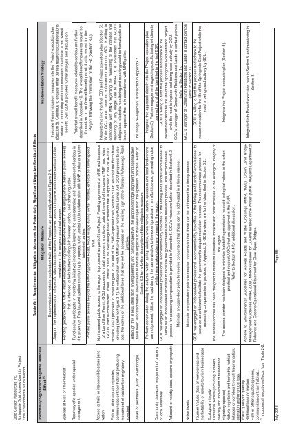
Gold Canyon Resources Inc. Springpole Gold Access Corridor Project Final Environmental Study Report Table 6-1: Supplemental Mitigation Measures for Potentially Significant Negative Residual Effects Potentially Significant Negative Residual Effect (1) Mitigation Measure Implementation Strategy Species at Risk or Their Habitat Recovery of a species under special management Access to trails or inaccessible areas (and water) Fish or other aquatic species, communities or their habitat (including movement of resident or migratory species) Views or aesthetics (Birch River bridge) Community character, enjoyment of property or local amenities Adjacent or nearby uses, persons or property Decommission historic exploration trails at the Property, as generally shown in Figure 2-1. Support the implementation of specific silvicultural practices in approved areas to improve and create caribou habitat elsewhere in the range or proximal ranges. Pending guidance from MNR, install educational signage elsewhere within in the range (where there is public access) that is intended to help hunters distinguish between caribou and other ungulates. Fund and/or participate in monitoring initiatives intended to improve the understanding and management of caribou in the province. This focused caribou monitoring is proposed to be carried out in collaboration with MNR and/or any other interested parties. Prohibit public access beyond the FMP Approved Road, focus usage during winter months, enforce 50 km/hr speed limit. No increased public access to the region is proposed as part of this Project. Pending agreement of MNR and issuance of a Land User Permit, GCU proposes to install a modern, monitored gate at the end of the current FMP road when GCU’s road is constructed. When Domtar builds the Wenasaga Road extension that is approved in the 2014-2019 timeline, GCU proposes to move the gate to the end of the FMP-approved road, which is ~1km south of the Birch River crossing (refer to Figure 2-1). In collaboration with MNR and pursuant to the Public Lands Act, GCU proposes to also post the names of the additional lakes that may not be accessed on the existing sign at the Tarpley / Wenasaga Road junction. Although this is less ideal from an engineering and cost perspective, the proposed bridge alignment and approaches have been relocated further downstream to minimize impacts to the viewscape from the upstream direction. Refer to Section 6.3 for a further description of this mitigation measure. Perform construction during the autumn-winter-spring window, when remote tourism operators and local landowners are not present. Utilize the road during this same window to the extent practical in an effort to avoid generating noise while these stakeholders are present in the region. GCU has engaged an independent professional recommended by the office of the Mining and Lands Commissioner to serve as an independent arbitrator to facilitate the government's dispute resolution process. The recommended process for assessing compensation is provided in Appendix 6. GCU’s views are further described in Section 6.2. Maintain an open-door policy to receive concerns so that these can be addressed in a timely manner. Noise levels Maintain an open-door policy to receive concerns so that these can be addressed in a timely manner. Tourism Values (loss of remoteness and marketability of remote tourism businesses) Ecological integrity Terrestrial wildlife (including numbers, diversity and movement of resident or migratory species) Natural vegetation and terrestrial habitat linkages or corridors through fragmentation, alteration and/or critical loss. Water quality or quantity Sedimentation or erosion Fish or other aquatic species, communities or their habitat… Includes all negative effects from Table 2-2. (1) GCU has engaged an independent professional recommended by the office of the Mining and Lands Commissioner to serve as an arbitrator to facilitate the government's dispute resolution process. The recommended process for assessing compensation is provided in Appendix 6. GCU’s views are further described in Section 6.2. The access corridor has been designed to minimize cumulative impacts with other activities to the ecological integrity of the region. The access corridor has been designed to minimize habitat fragmentation, to avoid biological values to the extent practical and respect AOCs that are approved in the FMP. Refer to Section 6.4 for additional discussion. Adhere to Environmental Guidelines for Access Roads and Water Crossings (MNR, 1995), Crown Land Bridge Management Guidelines (MNR, 2008), MNR Guidelines for Culverts Installed in the Winter (MNR, 1996) and Department of Fisheries and Oceans Operational Statement for Clear Span Bridges. Integrate these mitigation measures into the Project execution plan (Section 5). Continue to engage other parties regarding collaborations related to monitoring and other measures to achieve a net overall benefit. DST (2012) provides further analysis and discussion. Potential overall benefit measures related to caribou are further described in Appendix 10. The overall benefit measures would be formalized in an Overall Benefit permit that is issued for the Project following the conclusion of the EA (Section 3.4). Integrate this into the final ESR and Project execution plan (Section 5). While GCU would have no enforcement authority, GCU is willing to collaborate with MNR regarding the monitoring of the corridor and reporting of any illegal use to MNR. It is envisioned that GCU’s obligations related to monitoring and reporting would be formalized in an issued approval that is in accordance with MNR policy. The bridge re-alignment is reflected in Appendix 7. Integrate this approach directly into the Project execution plan (Section 5). Further engagement regarding specific timing windows is planned and shall be identified in the final ESR. GCU is willing to fund this process and adhere to the recommendation for the life of the Springpole Gold definition project while the road is in place and being used actively by GCU. GCU’s Manager of Community Relations and Lands is contact person (refer to Section 1). GCU’s Manager of Community Relations and Lands is contact person (refer to Section 1). GCU is willing to fund this process and adhere to the recommendation for the life of the Springpole Gold Project while the road is being used actively by GCU. Integrate into Project execution plan (Section 5). Integrated into Project execution plan in Section 5 and monitoring in Section 8. July 2013 Page 55
- Page 17 and 18: Gold Canyon Resources Inc. Springpo
- Page 19 and 20: Gold Canyon Resources Inc. Springpo
- Page 21 and 22: Gold Canyon Resources Inc. Springpo
- Page 23 and 24: Gold Canyon Resources Inc. Springpo
- Page 25 and 26: Gold Canyon Resources Inc. Springpo
- Page 27 and 28: Gold Canyon Resources Inc. Springpo
- Page 29 and 30: Gold Canyon Resources Inc. Springpo
- Page 31 and 32: Gold Canyon Resources Inc. Springpo
- Page 33 and 34: Gold Canyon Resources Inc. Springpo
- Page 35 and 36: Gold Canyon Resources Inc. Springpo
- Page 37 and 38: Gold Canyon Resources Inc. Springpo
- Page 39 and 40: Gold Canyon Resources Inc. Springpo
- Page 41 and 42: Gold Canyon Resources Inc. Springpo
- Page 43 and 44: Gold Canyon Resources Inc. Springpo
- Page 45 and 46: Gold Canyon Resources Inc. Springpo
- Page 47 and 48: Gold Canyon Resources Inc. Springpo
- Page 49 and 50: Gold Canyon Resources Inc. Springpo
- Page 51 and 52: Gold Canyon Resources Inc. Springpo
- Page 53 and 54: Gold Canyon Resources Inc. Springpo
- Page 55 and 56: Gold Canyon Resources Inc. Springpo
- Page 57 and 58: Gold Canyon Resources Inc. Springpo
- Page 59 and 60: Gold Canyon Resources Inc. Springpo
- Page 61 and 62: Gold Canyon Resources Inc. Springpo
- Page 63 and 64: Gold Canyon Resources Inc. Springpo
- Page 65 and 66: Gold Canyon Resources Inc. Springpo
- Page 67: Gold Canyon Resources Inc. Springpo
- Page 71 and 72: Gold Canyon Resources Inc. Springpo
- Page 73 and 74: Gold Canyon Resources Inc. Springpo
- Page 75 and 76: Gold Canyon Resources Inc. Springpo
- Page 77 and 78: Gold Canyon Resources Inc. Springpo
- Page 82: APPENDIX 2 LETTERS FROM HORIZON ARC
- Page 87 and 88: Round 1 Consultation - Early pre-co
- Page 89 and 90: APPENDIX 4 BIOLOGICAL CONSTRAINTS R
- Page 91 and 92: Gold Canyon Resources Inc. Springpo
- Page 93 and 94: Gold Canyon Resources Inc. Springpo
- Page 95 and 96: Gold Canyon Resources Inc. Springpo
- Page 98: Gold Canyon Resources Inc. Springpo
- Page 101: Gold Canyon Resources Inc. Springpo
- Page 115 and 116: Gold Canyon Resources Inc. Springpo
- Page 117: Gold Canyon Resources Inc. Springpo
<strong>Gold</strong> <strong>Canyon</strong> Resources Inc.<br />
Springpole <strong>Gold</strong> Access Corridor Project<br />
<strong>Final</strong> <strong>Environmental</strong> <strong>Study</strong> <strong>Report</strong><br />
Table 6-1: Supplemental Mitigation Measures for Potentially Significant Negative Residual Effects<br />
Potentially Significant Negative Residual<br />
Effect (1) Mitigation Measure Implementation Strategy<br />
Species at Risk or Their Habitat<br />
Recovery of a species under special<br />
management<br />
Access to trails or inaccessible areas (and<br />
water)<br />
Fish or other aquatic species,<br />
communities or their habitat (including<br />
movement of resident or migratory<br />
species)<br />
Views or aesthetics (Birch River bridge)<br />
Community character, enjoyment of property<br />
or local amenities<br />
Adjacent or nearby uses, persons or property<br />
Decommission historic exploration trails at the Property, as generally shown in Figure 2-1.<br />
Support the implementation of specific silvicultural practices in approved areas to improve and create caribou habitat<br />
elsewhere in the range or proximal ranges.<br />
Pending guidance from MNR, install educational signage elsewhere within in the range (where there is public access)<br />
that is intended to help hunters distinguish between caribou and other ungulates.<br />
Fund and/or participate in monitoring initiatives intended to improve the understanding and management of caribou in<br />
the province. This focused caribou monitoring is proposed to be carried out in collaboration with MNR and/or any other<br />
interested parties.<br />
Prohibit public access beyond the FMP Approved Road, focus usage during winter months, enforce 50 km/hr speed<br />
limit.<br />
No increased public access to the region is proposed as part of this Project. Pending agreement of MNR and issuance<br />
of a Land User Permit, GCU proposes to install a modern, monitored gate at the end of the current FMP road when<br />
GCU’s road is constructed. When Domtar builds the Wenasaga Road extension that is approved in the 2014-2019<br />
timeline, GCU proposes to move the gate to the end of the FMP-approved road, which is ~1km south of the Birch River<br />
crossing (refer to Figure 2-1). In collaboration with MNR and pursuant to the Public Lands Act, GCU proposes to also<br />
post the names of the additional lakes that may not be accessed on the existing sign at the Tarpley / Wenasaga Road<br />
junction.<br />
Although this is less ideal from an engineering and cost perspective, the proposed bridge alignment and approaches<br />
have been relocated further downstream to minimize impacts to the viewscape from the upstream direction. Refer to<br />
Section 6.3 for a further description of this mitigation measure.<br />
Perform construction during the autumn-winter-spring window, when remote tourism operators and local landowners<br />
are not present. Utilize the road during this same window to the extent practical in an effort to avoid generating noise<br />
while these stakeholders are present in the region.<br />
GCU has engaged an independent professional recommended by the office of the Mining and Lands Commissioner to<br />
serve as an independent arbitrator to facilitate the government's dispute resolution process. The recommended<br />
process for assessing compensation is provided in Appendix 6. GCU’s views are further described in Section 6.2.<br />
Maintain an open-door policy to receive concerns so that these can be addressed in a timely manner.<br />
Noise levels Maintain an open-door policy to receive concerns so that these can be addressed in a timely manner.<br />
Tourism Values (loss of remoteness and<br />
marketability of remote tourism businesses)<br />
Ecological integrity<br />
Terrestrial wildlife (including numbers,<br />
diversity and movement of resident or<br />
migratory species)<br />
Natural vegetation and terrestrial habitat<br />
linkages or corridors through fragmentation,<br />
alteration and/or critical loss.<br />
Water quality or quantity<br />
Sedimentation or erosion<br />
Fish or other aquatic species,<br />
communities or their habitat…<br />
Includes all negative effects from Table 2-2.<br />
(1)<br />
GCU has engaged an independent professional recommended by the office of the Mining and Lands Commissioner to<br />
serve as an arbitrator to facilitate the government's dispute resolution process. The recommended process for<br />
assessing compensation is provided in Appendix 6. GCU’s views are further described in Section 6.2.<br />
The access corridor has been designed to minimize cumulative impacts with other activities to the ecological integrity of<br />
the region.<br />
The access corridor has been designed to minimize habitat fragmentation, to avoid biological values to the extent<br />
practical and respect AOCs that are approved in the FMP.<br />
Refer to Section 6.4 for additional discussion.<br />
Adhere to <strong>Environmental</strong> Guidelines for Access Roads and Water Crossings (MNR, 1995), Crown Land Bridge<br />
Management Guidelines (MNR, 2008), MNR Guidelines for Culverts Installed in the Winter (MNR, 1996) and Department of<br />
Fisheries and Oceans Operational Statement for Clear Span Bridges.<br />
Integrate these mitigation measures into the Project execution plan<br />
(Section 5). Continue to engage other parties regarding collaborations<br />
related to monitoring and other measures to achieve a net overall<br />
benefit. DST (2012) provides further analysis and discussion.<br />
Potential overall benefit measures related to caribou are further<br />
described in Appendix 10. The overall benefit measures would be<br />
formalized in an Overall Benefit permit that is issued for the<br />
Project following the conclusion of the EA (Section 3.4).<br />
Integrate this into the final ESR and Project execution plan (Section 5).<br />
While GCU would have no enforcement authority, GCU is willing to<br />
collaborate with MNR regarding the monitoring of the corridor and<br />
reporting of any illegal use to MNR. It is envisioned that GCU’s<br />
obligations related to monitoring and reporting would be formalized in an<br />
issued approval that is in accordance with MNR policy.<br />
The bridge re-alignment is reflected in Appendix 7.<br />
Integrate this approach directly into the Project execution plan<br />
(Section 5). Further engagement regarding specific timing windows is<br />
planned and shall be identified in the final ESR.<br />
GCU is willing to fund this process and adhere to the<br />
recommendation for the life of the Springpole <strong>Gold</strong> definition project<br />
while the road is in place and being used actively by GCU.<br />
GCU’s Manager of Community Relations and Lands is contact person<br />
(refer to Section 1).<br />
GCU’s Manager of Community Relations and Lands is contact person<br />
(refer to Section 1).<br />
GCU is willing to fund this process and adhere to the<br />
recommendation for the life of the Springpole <strong>Gold</strong> Project while the<br />
road is being used actively by GCU.<br />
Integrate into Project execution plan (Section 5).<br />
Integrated into Project execution plan in Section 5 and monitoring in<br />
Section 8.<br />
July 2013 Page 55


