Wairoa - Bay of Plenty Regional Council
Wairoa - Bay of Plenty Regional Council
Wairoa - Bay of Plenty Regional Council

You also want an ePaper? Increase the reach of your titles
YUMPU automatically turns print PDFs into web optimized ePapers that Google loves.
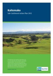
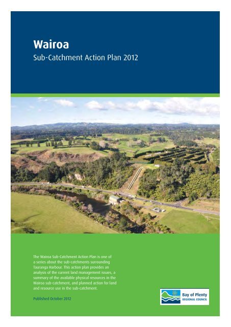
<strong>Wairoa</strong><br />
Sub-Catchment Action Plan 2012<br />
The <strong>Wairoa</strong> Sub-Catchment Action Plan is one <strong>of</strong><br />
a series about the sub-catchments surrounding<br />
Tauranga Harbour. This action plan provides an<br />
analysis <strong>of</strong> the current land management issues, a<br />
summary <strong>of</strong> the available physical resources in the<br />
<strong>Wairoa</strong> sub-catchment, and planned action for land<br />
and resource use in the sub-catchment.<br />
Published October 2012<br />
<strong>Wairoa</strong> Sub-Catchment Action Plan<br />
Page 1
Introduction<br />
The <strong>Wairoa</strong> River is the largest subcatchment<br />
in the Tauranga Harbour<br />
catchment. It is located to the south<br />
west <strong>of</strong> Tauranga City between<br />
Whakamarama and Tauranga<br />
Direct Roads. The <strong>Wairoa</strong> River<br />
sub-catchment is 46267 hectares is<br />
area and is part <strong>of</strong> the Tauranga and<br />
Otanewainuku ecological districts.<br />
The sub-catchment is about 36 km long<br />
and 15 km wide. It includes 1570 km <strong>of</strong><br />
stream margins and 0.3 km <strong>of</strong> harbour<br />
margin. The primary waterway in the<br />
sub-catchment is the <strong>Wairoa</strong> River.<br />
There are 35 named tributary streams<br />
and numerous unnamed tributaries.<br />
Trust Power operates the Kaimai Hydro<br />
Electricity scheme with four power<br />
generators located throughout the subcatchment<br />
– Lloyd Mandeno, Lower<br />
Mangapapa, Ruahihi and Kaimai 5.<br />
The most common vegetation cover<br />
in the sub-catchment is pastoral<br />
vegetation at 47 percent <strong>of</strong> total area.<br />
It is found mostly in the middle and<br />
lower sections <strong>of</strong> the sub-catchment.<br />
Native bush is mainly in the upper<br />
sub-catchment (41 percent), and<br />
horticultural land (nine percent) is only<br />
in the lower sub-catchment.<br />
Sub-catchment soils are derived from<br />
air-fall ash and belong to the Katikati<br />
soil series. The geology <strong>of</strong> the subcatchment<br />
is derived from thin rhyolitic<br />
tephra overlying loess and weathered<br />
rhyolitic tephra. The soils are classified<br />
Typic Orthic Allophanic, which have<br />
a high clay content. These soils are<br />
versatile with no rooting barriers;<br />
however the physical structure is poor.<br />
This means these soils are vulnerable<br />
to erosion under poor vegetation cover<br />
or intensive land-use. Soils on the<br />
floodplains and lower flats are formed<br />
from a mixture <strong>of</strong> peat and alluvial<br />
rhyolitic ash with wetness limitations to<br />
production.<br />
Source: BOPRC, ESRI, i-cubed, USGS, NASA, NOA<br />
Source: BOPRC, ESRI, i-cubed, USGS, NASA, NOA<br />
Page 2<br />
<strong>Bay</strong> <strong>of</strong> <strong>Plenty</strong> <strong>Regional</strong> <strong>Council</strong>
Land management<br />
What is the problem?<br />
Soil has been and continues to be lost from the<br />
Tauranga Harbour catchment at moderate to high<br />
rates, especially where steep land is subject to cattle<br />
or deer grazing, or where earthworks are not carefully<br />
managed. Recent sediment studies indicate the<br />
<strong>Wairoa</strong> River sub-catchment contributes the highest<br />
total sediment yield to the harbour <strong>of</strong> 49630 tonnes/<br />
year, which equates to 1.1 tonnes/hectare/year from<br />
46267 hectares.<br />
Soil quality has not been monitored in the <strong>Wairoa</strong><br />
catchment, but results from other similar <strong>Bay</strong> <strong>of</strong><br />
<strong>Plenty</strong> sites indicate generally healthy soils, with the<br />
exception <strong>of</strong> high levels <strong>of</strong> nitrogen on sheep, beef<br />
and deer farms, and excessively high levels on dairy<br />
farms (which have increased over 300 percent in<br />
the last ten years). While positive from a production<br />
perspective, high nitrogen levels represent a risk to<br />
water quality through leaching and eutrophication.<br />
Soils on kiwifruit orchards have healthy nitrogen levels<br />
but very high and increasing levels <strong>of</strong> phosphorus.<br />
While phosphates do not leach in the same way as<br />
nitrogen, they still represent a significant risk to water<br />
quality if washed into waterways by erosion.<br />
Livestock access to a stream or wetland, or the area<br />
immediately around them, degrades water quality by<br />
increasing nutrients, faecal matter and sediment in the<br />
waterway. Stock access can increase stream bank<br />
erosion by stock treading and damaging soil structure,<br />
and by eating and degrading vegetation on the stream<br />
bank.<br />
Water quality may also be degraded by excess<br />
nutrients in streams from fertilisers, farm run<strong>of</strong>f and<br />
urine patch leaching. Sediment can enter waterways<br />
from major construction sites (such as subdivision and<br />
roading) and forestry at harvest time. These and other<br />
pollutants are generally unintentional by-products <strong>of</strong><br />
activities such as farming and construction.<br />
Water quality monitoring by the <strong>Regional</strong> <strong>Council</strong><br />
in 2011 shows that the <strong>Wairoa</strong> River met the<br />
requirements <strong>of</strong> the Ministry <strong>of</strong> Health guidelines<br />
for swimming, exceeded the median faecal coliform<br />
standard <strong>of</strong> 100 cfu/100ml for stock water supply<br />
and exceeded nutrient levels that might promote<br />
undesirable biological growth.<br />
What will we do about it?<br />
▪<br />
▪<br />
▪<br />
▪<br />
▪<br />
▪<br />
▪<br />
Promote riparian margin fencing to exclude stock<br />
and protect water quality<br />
Promote and help landowners plant riparian<br />
margins to act as filters and help reduce pollutants<br />
entering streams through surface run<strong>of</strong>f<br />
Encourage stock stream crossings, such as<br />
bridges, to protect the water quality <strong>of</strong> streams<br />
Support retirement <strong>of</strong> steep erodible land<br />
Protect existing indigenous biodiversity<br />
Protect existing wetlands<br />
Work with landowners, other agencies and other<br />
sections <strong>of</strong> <strong>Regional</strong> <strong>Council</strong> to ensure consistent<br />
land and water quality management.<br />
Current riparian margin fencing protection:<br />
Stock<br />
excluded<br />
1440 km 130 km<br />
Stock<br />
have<br />
access<br />
The stock excluded figure indicates those stream<br />
margins that are fenced <strong>of</strong>f or are currently not available<br />
for stock grazing, for example, horticulture, forestry, and<br />
native bush.<br />
<strong>Wairoa</strong> Sub-Catchment Action Plan<br />
Page 3
Land use capability classification in<br />
the <strong>Wairoa</strong> sub-catchment<br />
Sustainable land use and management is essential to<br />
ensure the <strong>Bay</strong> <strong>of</strong> <strong>Plenty</strong> maintains clean waterways,<br />
productive soils and indigenous biodiversity. How the<br />
land is used and managed can have a direct effect on<br />
its potential long-term sustainability.<br />
The majority <strong>of</strong> land in this sub-catchment is Land<br />
Use Capability (LUC) Class 6 - rolling and steep<br />
landscapes. There are significant areas <strong>of</strong> LUC<br />
Class 7 and 8 lands – steep to very steep land - in<br />
the middle and upper catchment. Highly productive<br />
LUC Class 2, 3 and 4 - gentle to rolling lands - are<br />
primarily in the lower catchment.<br />
6817 ha<br />
1059 ha<br />
3689 ha<br />
Land use capability classification in the <strong>Wairoa</strong><br />
sub-catchment<br />
5799 ha<br />
21498 ha<br />
6675 ha<br />
623 ha<br />
Smart Growth<br />
Corridor<br />
LUC Class LUC Units Percent<br />
2 2e 1, 2s 1 2<br />
3 3e 1, 3e 2, 3e 8, 3e 8 + 6e 11, 3w 1 8<br />
4 4e 1, 4e 2, 4e 9, 4e 12 14<br />
5 5c 1 1<br />
6 6e 1, 6e 2, 6e 3, 6e 4, 6e 4 + 3e 2, 6e 11, 6w 1 47<br />
7 7e 1, 7e 7, 7e 8 13<br />
8 8e 4 15<br />
Erosion risk in the <strong>Wairoa</strong> sub-catchment<br />
A high proportion <strong>of</strong> Land Use Capability Class 6 land in the <strong>Wairoa</strong> sub-catchment has a medium-high risk <strong>of</strong><br />
erosion due to pastoral land use and forested lands post harvesting.<br />
717 ha<br />
2686 ha<br />
6085 ha<br />
1296 ha<br />
Erosion risk in the <strong>Wairoa</strong> sub-catchment<br />
Land Use Risk Percent<br />
Pasture Medium 13<br />
Pasture High 3<br />
Exotic forest Medium 6<br />
Exotic forest High 2<br />
Smart Growth Corridor<br />
Page 4<br />
<strong>Bay</strong> <strong>of</strong> <strong>Plenty</strong> <strong>Regional</strong> <strong>Council</strong>
Land cover in the <strong>Wairoa</strong> sub-catchment<br />
11593 ha<br />
7101 ha<br />
1020 ha<br />
26311 ha<br />
Land cover in the <strong>Wairoa</strong> sub-catchment<br />
Vegetation Percent<br />
Exotic 15<br />
Horticulture 2<br />
Indigenous 57<br />
Pasture 25<br />
Smart<br />
Growth<br />
Corridor<br />
Existing protection status in the <strong>Wairoa</strong> sub-catchment<br />
1103 ha<br />
171 ha<br />
191 ha<br />
1138 ha<br />
16967 ha<br />
Existing protection status in the <strong>Wairoa</strong> sub-catchment<br />
Class<br />
Percent<br />
DOC Reserve 37<br />
BOPRC Covenant 2<br />
QEII 0.4<br />
District Reserve 0.4<br />
WBOPDC Covenant 2<br />
Smart<br />
Growth<br />
Corridor<br />
<strong>Wairoa</strong> Sub-Catchment Action Plan<br />
Page 5
Land management survey 2011<br />
Field work<br />
In developing the <strong>Wairoa</strong> Sub-Catchment Action Plan,<br />
<strong>Bay</strong> <strong>of</strong> <strong>Plenty</strong> <strong>Regional</strong> <strong>Council</strong> undertook field surveys<br />
<strong>of</strong> 72 properties in the catchment area in January and<br />
February 2012. The properties surveyed covered 16<br />
percent <strong>of</strong> the catchment. Priority was given to large<br />
properties that had waterways flowing through them or<br />
along their boundary. Areas with formal protection status<br />
were not surveyed as they already have management<br />
plans in place. Field work included an assessment<br />
<strong>of</strong> land use, steam margins, erosion features and<br />
biodiversity features.<br />
The table summarises the field work:<br />
Land use<br />
Stream<br />
margins<br />
Erosion<br />
features<br />
Biodiversity<br />
features<br />
▪<br />
▪<br />
▪<br />
▪<br />
▪<br />
Land owner feedback<br />
▪<br />
▪<br />
▪<br />
▪<br />
Type and rationale<br />
Land Use Capability classification<br />
based on physical resources<br />
Protection measures (if any)<br />
General condition and upkeep<br />
Estimated length (both protected and<br />
unprotected)<br />
GPS track <strong>of</strong> any stream channels not<br />
evident in GIS database maps<br />
Estimated size and trend direction<br />
Photographs and GPS points (either<br />
at feature or where the photo was<br />
taken)<br />
Estimated extent <strong>of</strong> land area covered<br />
and the type <strong>of</strong> vegetation (e.g.<br />
native, introduced species)<br />
<strong>Bay</strong> <strong>of</strong> <strong>Plenty</strong> <strong>Regional</strong> <strong>Council</strong>, NZ Landcare Trust and<br />
Department <strong>of</strong> Conservation met with land owners on<br />
10 September 2012 to gather their concerns, challenges<br />
and priorities. The land management issues raised<br />
included:<br />
Priority 1 – Riparian Fencing<br />
▪ Need more meaningful contributions to<br />
environmental costs.<br />
▪ Fund the fencing <strong>of</strong>f <strong>of</strong> substantial streams and<br />
plantings. Not at farmers’ expense.<br />
▪ Who looks after excluded areas, i.e. fenced <strong>of</strong>f<br />
areas? Where does responsibility lie?<br />
▪ The financial outlay to do the fencing.<br />
▪ Investigate greater rate remission? (for ‘retired’ land.)<br />
▪ Cost <strong>of</strong> fencing – implementation and ongoing<br />
maintenance.<br />
Priority 2 – Messages to agencies<br />
▪ Control <strong>of</strong> wildlife in the DOC estate, especially<br />
as it was promised some years ago, up from<br />
Ngamuwahine.<br />
▪ Noxious weeds including gorse. <strong>Council</strong> should lead<br />
by example.<br />
▪ Storm water management (including roads).<br />
▪ Pest control. What is happening in the bush area <strong>of</strong><br />
Omanama Gorge.<br />
▪ A tendency for good ideas becoming mandated rules.<br />
▪ Confusion from government departments, lack <strong>of</strong><br />
cooperation (different government departments<br />
saying different things).<br />
▪ Cost <strong>of</strong> riparian plants (too high).<br />
▪ Sediment – funding from BOP regional council etc to<br />
tarseal / maintain unsealed roads to reduce this and<br />
improve water quality.<br />
▪ Improve water flow paths, including road run-<strong>of</strong>fs.<br />
Priority 3 – Plant pest control<br />
▪ Management <strong>of</strong> invasive plants (e.g. honeysuckle).<br />
▪ Spread <strong>of</strong> noxious weeds.<br />
▪ Subsidies for pest control rat and possum bait.<br />
Priority 4 – Water quality<br />
▪ Water quality – farmed stock are not the only animals<br />
reducing quality – ducks, geese etc.<br />
▪ Sediment - more credit to be given to pasture as a<br />
filter for sediment retention.<br />
▪ Life in water “a measure” <strong>of</strong> improvement and quality.<br />
Priority 5 – Money<br />
▪ Not enough flat land to farm to compensate for<br />
fencing steep land and maintain income.<br />
▪ Money / funding.<br />
▪ Insufficient subsidisation <strong>of</strong> public good works on<br />
private land.<br />
▪ Funding – ongoing once a project begins.<br />
▪ Full subsidy for “personal” circumstances (i.e. ill heal<br />
th).<br />
Priority 6 – Land management<br />
▪ Erosion – sediment from new subdivisions.<br />
▪ Need to go back to basics, reducing stocking rate<br />
and reducing fertiliser.<br />
▪ Erosion leading to sediment.<br />
▪ Proposed industrial dense residential sites causing<br />
pollution.<br />
▪ Control <strong>of</strong> run<strong>of</strong>f from development.<br />
Priority 7 – Research<br />
▪ Sediment – more objective assessment.<br />
Priority 8 – Responsibility for management<br />
▪ Willows clogging up rivers / causing erosion.<br />
Priority 9 – Riparian management<br />
▪ Incorrect species planted on stream edges.<br />
▪ Flooding <strong>of</strong> <strong>Wairoa</strong> River: damage to banks; types <strong>of</strong><br />
plants which will withstand floods.<br />
▪ Stock in water (cattle).<br />
Iwi/hapū feedback<br />
Iwi and hapū with an interest in the area:<br />
▪ Iwi: Ngāti Ranginui<br />
Page 6<br />
<strong>Bay</strong> <strong>of</strong> <strong>Plenty</strong> <strong>Regional</strong> <strong>Council</strong>
▪ Hapū: Pirirakau, Ngāti Hangarau, Ngāti Kahu, Ngāti<br />
Pango, Ngāti Rangi<br />
A summary <strong>of</strong> concerns, challenges and priorities are:<br />
▪ Protection and Restoration <strong>of</strong> Pukewhanake Pa site<br />
▪ Protection <strong>of</strong> Tahataharoa<br />
▪ Restoration <strong>of</strong> harakeke species<br />
▪ Providing or increasing Kawau colony areas for the<br />
continued presence <strong>of</strong> a cultural indicator<br />
▪ The enhancement <strong>of</strong> all tributaries <strong>of</strong> the <strong>Wairoa</strong><br />
River to promote increased water quality health<br />
▪ Cultural health index investigations achieved in<br />
partnership with BOPRC and Tangatawhenua as a<br />
baseline<br />
▪ Research and investigate the environmental impacts<br />
<strong>of</strong> agrichemical run-<strong>of</strong>f<br />
▪<br />
▪<br />
▪<br />
▪<br />
▪<br />
▪<br />
▪<br />
Protect the <strong>Wairoa</strong> River and its environs as part <strong>of</strong><br />
the heritage landscape.<br />
Recognise the critical decline <strong>of</strong> biodiversity and risk<br />
to indigenous flora and fauna within Ngāti Kahu rohe.<br />
Promote information sharing about the decline <strong>of</strong><br />
biodiversity.<br />
Protect and enhance the Tuna (eel) population and/<br />
or habitat within the <strong>Wairoa</strong> River.<br />
Protect riparian and buffer zones around waterways<br />
to ensure their ecological function is maintained.<br />
Encourage the protection <strong>of</strong> existing indigenous<br />
forest remnants, bush stands or regenerating<br />
indigenous vegetation through use <strong>of</strong> buffer zones.<br />
Prevent direct stock access to waterways to avoid<br />
discharge or damage by stock.<br />
Actions<br />
Three main land management issues were identified, common to the surveyed properties, in the <strong>Wairoa</strong> subcatchment.<br />
These are set out in the table below.<br />
Actions Milestones Who is involved?<br />
Improving riparian protection<br />
▪ Work with landowners to apply sustainable land use methods and practices<br />
to maintain and/or repair streambanks and to improve water quality.<br />
▪ Remove all stock access to streams, fence remaining 130km and promote<br />
planting <strong>of</strong> riparian margins to eliminate the effects <strong>of</strong> livestock, polluted<br />
water run<strong>of</strong>f and erosion.<br />
▪ Begin stream margin remedial works such as bank re-contouring, riparian<br />
planting and engineering works - using relevant legislation relating to<br />
riparian management.<br />
▪ Identify site-specific solutions.<br />
5km <strong>of</strong> new<br />
riparian fencing<br />
per year<br />
1 km <strong>of</strong> riparian<br />
planting per<br />
year<br />
▪<br />
▪<br />
▪<br />
<strong>Bay</strong> <strong>of</strong> <strong>Plenty</strong><br />
<strong>Regional</strong> <strong>Council</strong><br />
Landowners<br />
Western <strong>Bay</strong> <strong>of</strong><br />
<strong>Plenty</strong> District<br />
<strong>Council</strong><br />
Improve erosion control and appropriate land use practices<br />
▪ Apply property level management plans to LUC class 6 & 7 pastoral and<br />
forestry land that has been identified as eroding or at risk <strong>of</strong> eroding.<br />
▪ Promote the need for land use change on LUC class 7 land pastoral land –<br />
advocate land retirement, forestry and suitable stock regimes.<br />
▪ Work with landowners to apply soil and water conservation methods and<br />
good land management practice to maintain and/or repair landscapes.<br />
▪ Increase the awareness <strong>of</strong> cattle and deer at high stocking rates on<br />
steeper slopes.<br />
▪ Ensure that landowners apply appropriate land management practices.<br />
50 properties<br />
with ‘at risk’<br />
land have<br />
management<br />
plans by 2022<br />
▪<br />
▪<br />
▪<br />
▪<br />
<strong>Bay</strong> <strong>of</strong> <strong>Plenty</strong><br />
<strong>Regional</strong> <strong>Council</strong><br />
Landowners<br />
Western <strong>Bay</strong> <strong>of</strong><br />
<strong>Plenty</strong> District<br />
<strong>Council</strong><br />
Department <strong>of</strong><br />
Conservation<br />
Improve biodiversity protection and enhancement<br />
▪ Advocate further covenanted areas within the sub-catchment<br />
▪ Continue tree planting on private land in native or non-invasive exotic<br />
species<br />
▪ Liaise with Waikato <strong>Regional</strong> <strong>Council</strong> and Department <strong>of</strong> Conservation<br />
on coordinating management <strong>of</strong> the Kaimai Mamaku Range and its<br />
catchments as part <strong>of</strong> the Kaimai Catchments Project<br />
▪ Work with landowners and community groups to protect identified<br />
biodiversity areas in the sub-catchment by establishing native plant<br />
populations and controlling nuisance populations <strong>of</strong> pest plants and<br />
animals.<br />
By 2022 an<br />
additional 23<br />
sites, including<br />
2 High Value<br />
Ecological<br />
Value sites,<br />
are managed<br />
for biodiversity<br />
protection and<br />
enhancement.<br />
▪<br />
▪<br />
▪<br />
▪<br />
▪<br />
<strong>Bay</strong> <strong>of</strong> <strong>Plenty</strong><br />
<strong>Regional</strong> <strong>Council</strong><br />
Landowners<br />
Western <strong>Bay</strong> <strong>of</strong><br />
<strong>Plenty</strong> District<br />
<strong>Council</strong><br />
Department <strong>of</strong><br />
Conservation<br />
Community Care<br />
Groups<br />
<strong>Wairoa</strong> Sub-Catchment Action Plan<br />
Page 7
Monitoring<br />
<strong>Wairoa</strong> catchment action plan key performance indicators (KPI’s)<br />
<strong>Wairoa</strong> sub-catchment targets<br />
Key performance indicator<br />
Current<br />
Year<br />
ending 30<br />
June 2012<br />
Year<br />
1*<br />
Year<br />
2*<br />
Year<br />
3*<br />
Year<br />
4*<br />
Year<br />
5*<br />
Years<br />
6*-10<br />
Total<br />
Soil and water<br />
Km <strong>of</strong> riparian margins excluded from stock.<br />
Number <strong>of</strong> properties ‘at risk’ for erosion which are<br />
managed by a property management plan.<br />
91% -<br />
1440 km<br />
New<br />
measure<br />
5 km 5 km 5 km 5 km 5 km 5 km 50 km<br />
5 5 5 5 5 5 50<br />
Biodiversity<br />
High value ecological sites on private land that are<br />
under active management.<br />
Number <strong>of</strong> areas <strong>of</strong> indigenous forest or wetland<br />
being actively managed by the community to protect<br />
their biodiversity values.<br />
New<br />
measure<br />
New<br />
measure<br />
0 0 0 1 0 1 2<br />
3 3 3 3 3 3 30<br />
Note: The progress to achieve the targets will be reported on annually.<br />
*Year 1 ends at 30 June 2013, Year 2 ends at 30 June 2014 etc.<br />
Case study<br />
Cedric and Bev Stone own a 140 ha rolling hill<br />
country farm on the lower Kaimai area, which<br />
they have farmed Deer on for the past 25 years.<br />
Weak volcanic soils <strong>of</strong> the area make farming a<br />
challenge, as steeper slopes are prone to erosion,<br />
and meandering streams difficult to manage. The<br />
Stones have recognised their farm’s strengths and<br />
weaknesses and focussed their efforts on improving<br />
soil structure and fertility on the more productive flats,<br />
while retiring steeper un-productive areas and native<br />
bush areas. “We believe it is important to protect<br />
the remnants <strong>of</strong> native flora and fauna from further<br />
deterioration and retire them to enhance the stability<br />
<strong>of</strong> the surrounding hillsides” said Cedric. Fencing to<br />
exclude stock from native bush or riparian areas is<br />
important for stabilising soil, allowing native regrowth<br />
and trapping run<strong>of</strong>f nutrients.<br />
The Stones have developed a Ten Year Plan for<br />
the farm to prioritise their efforts to match land use<br />
to land type. To date they have retired 10 blocks<br />
ranging from 4 ha to 10 ha including another 3 ha <strong>of</strong><br />
An eroded hill side is retired from grazing by fencing out<br />
deer and laying hay over the exposed ground.<br />
Wetland from stock. The Stones have used financial<br />
assistance from <strong>Bay</strong> <strong>of</strong> <strong>Plenty</strong> <strong>Regional</strong> <strong>Council</strong> under<br />
a Riparian Management Plan agreement recently<br />
to fence <strong>of</strong>f stock from another wet gully on their<br />
property.<br />
For more information call a Land Resources<br />
Administration Officer on 0800 884 880.<br />
Page 8<br />
<strong>Bay</strong> <strong>of</strong> <strong>Plenty</strong> <strong>Regional</strong> <strong>Council</strong>