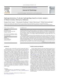
Jurnal Geoaplika (2010) Volume 5, Nomor 1, hal. 039 â 048 39 - ITB
Jurnal Geoaplika (2010) Volume 5, Nomor 1, hal. 039 â 048 39 - ITB
Jurnal Geoaplika (2010) Volume 5, Nomor 1, hal. 039 â 048 39 - ITB

Create successful ePaper yourself
Turn your PDF publications into a flip-book with our unique Google optimized e-Paper software.
<strong>Jurnal</strong> <strong>Geoaplika</strong> (<strong>2010</strong>)<br />
<strong>Volume</strong> 5, <strong>Nomor</strong> 1, <strong>hal</strong>. <strong>0<strong>39</strong></strong> – <strong>048</strong><br />
Yudi Indra Kusumah<br />
Suryantini<br />
Hendro H. Wibowo<br />
Horizontal Derivative from Gravity Data as a Tool for<br />
Drilling Target Guide in Wayang Windu Geothermal Field,<br />
Indonesia<br />
Diterima : 26 Sept. 2009<br />
Disetujui : 22 Nov. 2009<br />
© <strong>Geoaplika</strong> <strong>2010</strong><br />
Yudi Indra Kusumah *<br />
Star Energy, Wisma Mulia lt.51,<br />
Jl. Jend. Gatot Subroto no 42,<br />
Jakarta 12710, Indonesia.<br />
E-mail:<br />
yudi.kusumah@starenergy.co.id<br />
Suryantini<br />
Research Division on Applied<br />
Geology, Engineering Geology Study<br />
Program, Faculty of Earth Sciences<br />
and Technology, <strong>ITB</strong><br />
Jl. Ganesha 10, Bandung<br />
E-mail: suryantini@gc.itb.ac.id<br />
Hendro H. Wibowo<br />
Study Program of Geology<br />
Faculty of Earth Science and<br />
Technology (F<strong>ITB</strong>)<br />
Bandung Institute of Technology<br />
Jl. Ganesa 10 Bandung,<br />
Indonesia.<br />
Abstract – The density of the<br />
gravity survey points allows<br />
“horizontal derivative” filtering to<br />
be applied to the complete<br />
Bouguer anomaly (CBA) data.<br />
The horizontal derivative process<br />
produces maximum ridges over<br />
the contacts between different<br />
density body blocks. The image<br />
produced by the horizontal<br />
derivative algorithm shows some<br />
agreement to the known<br />
productive area which lies in the<br />
vicinity of the maxima of the<br />
horizontal derivative. The<br />
horizontal derivative maximum<br />
does not correspond well to the<br />
known fault pattern. It may<br />
possibly indicate the location of<br />
the margins of intrusive bodies or<br />
major volcanic facies changes.<br />
Keywords: horizontal derivative,<br />
gravity, permeability, fracture,<br />
gradient, intrusion, drilling<br />
Sari – Kerapatan titik<br />
pengamatan survei gravitasi<br />
memungkinkan proses filter<br />
"horizontal derivative" dilakukan<br />
terhadap data Complete Bouguer<br />
Anomaly (CBA). Proses<br />
horizontal derivatif menghasilkan<br />
nilai maksimum, berupa tinggian<br />
di peta, pada tempat-tempat<br />
dimana terdapat kontak antar<br />
blok batuan yang berbeda berat<br />
jenis. Peta yang dihasilkan dari<br />
algoritma horizontal derivative<br />
menunjukkan beberapa<br />
kesesuaian dengan daerah-daerah<br />
yang diketahui telah berproduksi,<br />
terletak di dekat nilai-nilai puncak<br />
di peta horizontal derivatif. Nilai<br />
maksimum horizontal derivatif<br />
kurang berasosiasi demgan polapola<br />
struktur yang telah diketahui.<br />
Nilai tersebut kemungkinan<br />
menunjukkan lokasi atau tepi dari<br />
tubuh intrusi atau perubahan<br />
besar spesies volkaniknya.<br />
Kata kunci: horizontal derivatif,<br />
gravitasi, permeabilitas, rekahan,<br />
gradien, intrusi, pemboran<br />
* Alamat korespondensi<br />
Introduction<br />
The Wayang Windu (WW) geothermal field is<br />
located in West Java Indonesia, at a distance<br />
of about 150 km SE of Jakarta, Indonesia<br />
(Figure 1). Currently the installed capacity is<br />
220 MWe. The field has been intensively<br />
explored, with a total of <strong>39</strong> wells drilled,<br />
including production, reinjection and slim<br />
hole exploration wells. Several geophysical<br />
surveys have been performed including<br />
magneto telluric (MT) surveys with 1 km<br />
spacing interval, gravity surveys which in<br />
places reaches 1 km station density,<br />
microearthquake (MEQ) survey and formation<br />
imaging well logs.<br />
The Wayang Windu geothermal system,<br />
associated with the Malabar, Wayang and<br />
Windu volcanic centers, is interpreted to be<br />
transitional between vapor-dominated and<br />
liquid-dominated. Deep wells encounter liquid<br />
reservoir with the top, prior to production,<br />
from 0 to 400 m asl (above sea level), which<br />
becomes progressively deeper toward the<br />
south. It is overlain by three separate vapordominated<br />
reservoirs, which become<br />
<strong>39</strong>
progressively s<strong>hal</strong>lower to the north, where<br />
the top of the reservoir is at 1150 m asl.<br />
The Wayang Windu volcanic setting is<br />
identified as an active geothermal system,<br />
characterized by the presence of volcanic<br />
center and series of intrusion as heat sources.<br />
Indications of geophysical features<br />
representative of intrusion bodies were<br />
derived from the combination of MT and<br />
gravity, and then validated by well<br />
information. This suggested the occurrence of<br />
microdiorite or andesite porphyry dykes.<br />
There is also a mineralogy study, reporting the<br />
presence of high temperature mineral,<br />
identified as amphibole zone in deeper part<br />
(Abrenica et al., 2009).<br />
In general, the vicinity of the margin in<br />
between the intrusion body and surrounding<br />
rock is susceptible to fracturing. They are<br />
radial and concentric with high angle in the<br />
late stage of fracture development. A<br />
hydrothermal system was then developed<br />
around intrusive bodies after deep penetrated<br />
meteoric water reaction with hot intrusion<br />
bodies and stimulated a convective flow<br />
circulation through this clustering of<br />
permeable zone.<br />
The horizontal derivative of potential field<br />
data is a technique used to enhance data. By<br />
taking the derivative along the x and y axis,<br />
this enhancement aims to define the<br />
anomalous body boundary and to separate<br />
with other anomalies through the relevance of<br />
analytical calculation. The calculation is<br />
achieved by comparing gravity profiles or<br />
contours, as the slope or rate of change of<br />
gradient with horizontal displacement, since<br />
the sharpness of a gravity profile is an<br />
indication of the depth of the anomalous mass.<br />
This paper outlines the application of gravity<br />
information to understand how the fracture<br />
zone is related to intrusion bodies. This study<br />
utilizes enhanced horizontal derivative<br />
analysis, integrated with fracture information<br />
from wellbore data, combined with other<br />
geophysical surveys to delineate a prospect<br />
area for well targeting.<br />
Figure 1: Location of Wayang Windu Geothermal field in West<br />
Java, Indonesia.<br />
40
Gravity Survey AT WW<br />
Gravity surveys have been conducted<br />
regularly at WW since exploration stage. The<br />
initial survey was carried out by Unocal<br />
Geothermal Indonesia in 1982 with 76<br />
stations, and then followed up by Pertamina in<br />
1985-1986 which carried out 256 stations.<br />
Low density spacing of stations and coverage<br />
area caused low resolution results and<br />
difficulties in interpretation. Unocal then<br />
carried out a microgravity survey in 2002<br />
which was continued by Star Energy in 2008<br />
which carried out a re-measurement of<br />
microgravity survey and systematically<br />
gridding gravity survey with high density<br />
spacing, for around 250 m - 1 km spacing and<br />
larger coverage area. This survey consists of<br />
135 additional stations and extended the area<br />
to the unexplored piece in the northern part of<br />
the Wayang Windu Geothermal field. The<br />
survey was completed in the end of 2008.<br />
Data was gained with very good quality and<br />
showing higher resolution resulst. All gravity<br />
data were analyzed to derive the final<br />
structural gravity map.<br />
The complete Bouguer anomaly was<br />
calculated for all stations, employing:<br />
a. the 1980 formula,<br />
b. terrain corrections to 50km radius,<br />
c. reduction in densities of 2.00, 2.20, 2.40<br />
and 2.60 g/cc.<br />
d. The Bouguer anomaly shows a regional<br />
high to the west and southwest, this<br />
positive anomaly persists at all reduction<br />
densities, and cannot be considered an<br />
artifact of the topography vs reduction<br />
density alone. The main features are<br />
relative gravity high in the south and west<br />
with decreasing gravity towards the NE.<br />
The gravity then increases again to a<br />
cluster of anomalies around the cluster in<br />
the middle area which shows SE-<br />
NW/NNW trending area prior to<br />
significant decrease again in north east<br />
and east area. This feature then indicates a<br />
significant regional structure which can be<br />
interpreted as high density bodies around<br />
Gunung Wayang and Windu. These<br />
gravity features are interpreted as<br />
expression of buried intrusive bodies,<br />
while more a attractive anomaly present<br />
in the northern area around the Malabar<br />
complex (Figure 2).<br />
Figure 2: Complete Bouguer anomaly in mgal of Wayang Windu<br />
Geothermal field overlie by well trajectory in mgal.<br />
41
Figure 3: Residual Bouguer anomaly in mgal of Wayang Windu<br />
Geothermal field using polynomial 3 overlie by well trajectories.<br />
To assess significant local anomalies,<br />
separation of regional from residual<br />
geophysical data was performed to enhance<br />
localized anomalies (Figure 3). The residual<br />
gravity values around the Malabar complex<br />
are clearly defined as high anomalies, while in<br />
the southern part of Wayang Windu and Bedil<br />
regional pattern still show more localized<br />
values. Most trends of anomalies are more<br />
clearly defined based on residual features. In<br />
the northern area, residuals show two peak<br />
anomalies, those indicate s<strong>hal</strong>low anomalies.<br />
Structural Modeling<br />
To examine the gravity models in relation to<br />
the 3D, MT modeling carried out by<br />
Geosystem in 2009, the residual gravity<br />
anomaly is overlain on the 3D MT resistivity.<br />
General positive correlation gravity high is<br />
modeled straight thorough the high, showing<br />
how the required dense body also corresponds<br />
to the 3D MT resistivity high. Modeling was<br />
carried out using WinGLink’s 2.75-D<br />
software, allowing the use of up to the limit of<br />
body strike length (3 km in the case of the<br />
modeled Malabar complex intrusive<br />
stockwork) (Figure 4).<br />
Horizontal Gradient<br />
Blakely (1995) stated that the horizontal<br />
gradient of gravity anomaly caused by a<br />
tabular body tends to overlie the edges of the<br />
body, if the edges are vertical and well<br />
separated from each other. The biggest<br />
advantage of the horizontal gradient method<br />
was its low susceptibility to the noise in the<br />
data, because it only requires the calculation<br />
of the two first-order horizontal derivatives of<br />
the field (Phillips, 1998). The method also has<br />
robust delineation, either s<strong>hal</strong>low or deep, in<br />
comparison with the vertical gradient, which<br />
is useful only for the s<strong>hal</strong>lower structures. The<br />
amplitude of the horizontal gradient (Cordell<br />
and Grauch, 1985) is expressed as:<br />
2<br />
g<br />
g<br />
<br />
HG <br />
(1)<br />
x<br />
y<br />
<br />
2<br />
42
Figure 4: Gravity modeling of Bouguer anomaly combined with<br />
resistivity MT.<br />
43
g<br />
g<br />
Where ( and ) are the horizontal<br />
x<br />
y<br />
derivatives of the gravity field in the x and y<br />
directions. The horizontal gradient amplitude<br />
of the complete Bouguer anomaly data of the<br />
Wayang Windu area was computed and<br />
illustrated in Figure 5.<br />
Contrast in between high gradient values and<br />
low gradient values were observed as<br />
scattered, and the pattern of high gradient<br />
anomalies is broad, but overall localized<br />
middle values are defined. Referring to<br />
Grauch and Cordell (1985), the limitation of<br />
the horizontal gradient methods for gravity<br />
data is that the horizontal gradient magnitude<br />
maxima can be offset from a position directly<br />
over the boundaries, if the boundaries are not<br />
near-vertical and close to each other.<br />
For selecting gradient values, the data have to<br />
be integrated with other information as<br />
guidance, to define gradient magnitude<br />
maxima correlated to area which are<br />
interpreted as intrusion boundaries data. MT<br />
information and well performance can be used<br />
as assistive tools as well as formation<br />
evaluation, based on other geoscientific<br />
assessment, for better interpretation.<br />
Figure 5: Horizontal derivative in mgal/m of the regional gravity<br />
data overlied with well trajectories. Mostly northern part wells as<br />
major productive well lying on 0.03-0.05 gradient values<br />
.<br />
Interesting results were found when medium<br />
high – high (0,03-0,05 mgal/m) gradient<br />
44
contrast values coincide with major<br />
productive area between the intrusive and the<br />
local reservoir rocks. These were interpreted<br />
from structural modeling of gravity and MT.<br />
Based on this agreement; it indicates that the<br />
geothermal areas in Wayang Windu are<br />
mostly located around intrusion boundaries<br />
especially for the deep sources<br />
Integration of data with resistivity, MEQ<br />
events, and high temperature minerals show<br />
correlation between maximum gradient,<br />
which have values of 0,03 and 0,05, with the<br />
existence of MEQ cluster, and existence of<br />
high temperature minerals showing<br />
correlation with each other. (Figure 6).<br />
This combination indicates that maximum<br />
gradient can be utilized to define fracture<br />
zones which are possibly favorable for<br />
production within the geothermal system.<br />
Integrated horizontal gradient as a derivative<br />
analysis with other information can lead to<br />
better understanding of the geothermal system<br />
itself and especially identification of a<br />
permeable fracture area.<br />
Permeable zones in the Wayang Windu<br />
reservoir have been identified primarily from<br />
field structural mapping including remote<br />
sensing interpretation. The fractures were then<br />
assessed based on wireline log analyses.<br />
Away from well bores, the recognition and<br />
characterization of fluid paths have been<br />
investigated using microearthquake (MEQ)<br />
analysis. The events observed during the<br />
survey time were mostly induced events<br />
triggered by injection water into injector wells<br />
through hydro-fracturing, where in 2007 the<br />
survey used MBB-1 as injector well.<br />
The integrated information of permeable<br />
zones based on all available data combined<br />
with specific values of contrast gradient<br />
horizontal derivative profile enhances the<br />
understanding area of interest, which is<br />
interpreted as contacts between the intrusive<br />
bodies and the local reservoir rock.<br />
Application for Well Targeting<br />
The margin between intrusion bodies and<br />
surrounding rock is favorable development as<br />
fractured area. They are radial and concentric<br />
and high angle in the late stage of fracture<br />
development. Intrusion bodies themselves are<br />
less permeable areas. Therefore the delineated<br />
margin zone is essential to identify the<br />
geothermal system which developed around<br />
intrusive bodies after deep penetrated<br />
meteoric water reacts with hot intrusion<br />
bodies and stimulated a circulation convective<br />
flow through this clustering of permeable<br />
zones.<br />
Correspondence between horizontal<br />
derivatives, MEQ events and intrusion<br />
indications from high temperature mineral can<br />
help locate narrow bodies that can be<br />
delineated as an attractive zone, i.e. a fracture<br />
zone within the geothermal system for drilling<br />
targeting.<br />
45
SECTION S-N<br />
-2000 -1500 -1000 -500 0 500 1000 1500 2000 2500<br />
WWW-2<br />
WWW-1<br />
WWF-2 WWF-3<br />
WWF-1<br />
WWA-1ST<br />
WWA-3<br />
WWQ-4<br />
WWT-1 WWD-1 WWQ-5<br />
WWD-2<br />
WWA-4<br />
WWQ-2<br />
WWS-1<br />
MBA-2<br />
MBD-5<br />
MBA-3MBA-4<br />
MBD-1RD1<br />
0 2000 4000 6000 8000 10000 12000 14000<br />
MBB-1<br />
2500 2000 1500 1000 500 0 -500 -1000 -1500 -2000<br />
0 500 1000 1500 2000 2500m<br />
CBA_mGal<br />
45.0<br />
40.0<br />
35.0<br />
30.0<br />
25.0<br />
20.0<br />
15.0<br />
10.0<br />
Res_mGal<br />
10.00<br />
5.00<br />
0.00<br />
-5.00<br />
-10.00<br />
1:70000<br />
9197185 9198000 9200000 9202000 9204000 9206000 9208000<br />
9210526<br />
Y (m)<br />
CBA_mGal<br />
Res_mGal<br />
mGal/m<br />
0.003000<br />
0.002500<br />
0.002000<br />
0.001500<br />
0.001000<br />
0.000500<br />
9197185 9198000 9200000 9202000 9204000 9206000 9208000<br />
9210526<br />
Y (m)<br />
Figure 6: Integrated interpretation of resistivity, Bouguer, and<br />
residual gravity compared to MeQ event and high temperature<br />
mineral (red for amphibole, green for biotite and yellow for<br />
pyrophyllite).<br />
FHD<br />
46
MEQ Events (S-N)<br />
-2000 -1500 -1000 -500 0 500 1000 1500 2000<br />
WWW-2<br />
WWF-2WWF-3<br />
WWW-1<br />
WWF -1<br />
WWA-4<br />
WWA-2<br />
WWA-1ST<br />
WWA-3<br />
MBA-2<br />
MBD-5<br />
MBA-1<br />
MBA-3 MBA-4<br />
MBD-1RD1<br />
MBD-2<br />
WWQ-4<br />
WWD-1<br />
WWT-1<br />
WWQ-5<br />
WWD-2<br />
WWQ-2<br />
WWS-1<br />
MBB-1<br />
2000 1500 1000 500 0 -500 -1000 -1500 -2000<br />
0 1000 2000 3000 4000 5000 6000 7000 8000 9000 10000 11000 12000 13000 14000 15000 16000<br />
0 500 1000 1500 2000 2500m<br />
High Temperature Minerals<br />
-2000 -1500 -1000 -500 0 500 1000 1500 2000<br />
WWW-2<br />
WWF-2WWF-3<br />
WWW-1<br />
WWF-1<br />
WWA-4<br />
WWA-2<br />
WWA-1ST<br />
WWA-3<br />
WWT-1<br />
WWD-1<br />
WWD-2<br />
MBA-2<br />
MBD-5<br />
MBA-1<br />
MBA-3 MBA-4<br />
MBD-1RD1<br />
MBD-2<br />
WWQ-4<br />
WWQ-5<br />
WWQ-2<br />
WWS-1<br />
MBB-1<br />
2000 1500 1000 500 0 -500 -1000 -1500 -2000<br />
0 1000 2000 3000 4000 5000 6000 7000 8000 9000 10000 11000 12000 13000 14000 15000 16000<br />
Figure 7 (continued): Integrated interpretation of resistivity, Bouguer,<br />
and residual gravity compared to MeQ event and high temperature<br />
mineral (red for amphibole, green for biotite and yellow for<br />
pyrophyllite)<br />
47
Conclusion<br />
<br />
<br />
<br />
Gravity and MT results identified<br />
possible high density bodies that were<br />
interpreted as intrusion bodies<br />
Enhancement with horizontal gradient<br />
analysis shows correspondence<br />
between specific values of horizontal<br />
gradient and productive fractures<br />
within the geothermal system.<br />
Based on this assessment, the next<br />
drilling target should take into<br />
consideration the result of horizontal<br />
derivative analysis for well targeting.<br />
Acknowledgements<br />
The author would like to express gratitude to<br />
the management of Star Energy Geothermal<br />
(Wayang Windu) Ltd. for permitting the<br />
authors to publish this paper. And show<br />
appreciation to Lukman Sutrisno and<br />
Wahyuddin Diningrat for discussion and<br />
figure preparation, and to Shanti R.A.<br />
Sugiono as well for editing.<br />
References<br />
Abrenica, A. B., Harijoko, A.,<br />
Kusumah, Y. I. and Bogie,<br />
I, Characteristic of<br />
hydrothermal alteration in<br />
part of the northern vapor<br />
dominated reservoir of the<br />
Wayang Windu<br />
Geothermal Field, West<br />
Java. In preparation for<br />
WGC <strong>2010</strong>.<br />
Rapolla, A., Cella, F., Fedi, M. and<br />
Florio, G., 2002. Improved<br />
techniques in data analysis<br />
and interpretation of<br />
potential fields: Examples<br />
of application in volcanic<br />
and seismically active<br />
areas. Annuals of<br />
Geophysics, 45(6): 745-<br />
749.<br />
Blakely, R. J., 1995. Potential<br />
Theory in Gravity and<br />
Magnetic Applications.<br />
Cambridge Univ. Press.<br />
Bogie I., Kusumah, Y. I. and<br />
Wisnandary, M. C., 2008.<br />
Overview of the Wayang<br />
Windu Geothermal Field,<br />
West Java, Indonesia.<br />
Geothermics, 37: 347-365.<br />
Cordell, L. and Grauch, V. J. S.,<br />
1985. Mapping Basement<br />
Magnetization Zones from<br />
Aeromagnetic Data in the<br />
San Juan Basin, New<br />
Mexico, in Hinze, W. J.,<br />
Ed., The Utility of<br />
Regional Gravity and<br />
Magnetic Anomaly Maps,<br />
Sot. Explor. Geophys., 181<br />
& 197.<br />
Milton, D, and Carl, S. C., 1988.<br />
Introduction<br />
to<br />
Geophysical Prospecting,<br />
McGraw Hill.<br />
Geosystem S. R. L., 2008. Final<br />
Report Passive Seismic<br />
Survey, Wayang Windu<br />
Geothermal Field,<br />
Processing<br />
and<br />
Interpretative Report:<br />
High-Precision Locations,<br />
Moment Tensor and Shear-<br />
Wave Splitting Analysis.<br />
Unpublished Report,<br />
Magma Nusantara Ltd..<br />
Kusumah, Y. I., De Luca, L. and<br />
Bogie, I., 2009. A recent<br />
microearthquake survey at<br />
the Wayang Windu<br />
Geothermal Field,<br />
Indonesia. Proceeding 30<br />
th. Annual EDC<br />
Geothermal Conference,<br />
pp. 79-86.<br />
Milsom, J., 2003. Field Geophysics.<br />
The Geological Field<br />
Guide Series, John Willey<br />
& Sons.<br />
Phillips, J. D., 1998. Processing and<br />
Interpretation of<br />
Aeromagnetic Data for the<br />
Santa Cruz Basin<br />
Patahonia Mountains Area,<br />
South-Central Arizona.<br />
U.S. Geological Survey<br />
Open-File Report 02-98.<br />
Salem, A., Furuya, S., Aboud E.,<br />
Elawadi, E., Jotaki, H. and<br />
Ushijima, K., 2005.<br />
Subsurface structural<br />
mapping using gravity data<br />
of Hohi Geothermal Area,<br />
Central Kyushu, Japan.<br />
Proceeding World<br />
Geothermal Congress<br />
2005.<br />
Masakatu, S., 2000. Igneous-related<br />
active geothermal system<br />
versus porphyry copper<br />
hydrothermal system.<br />
Proceedings World<br />
Geothermal Congress<br />
2000.<br />
Unocal Geothermal Indonesia, 2002.<br />
Resources Assessment<br />
Team, WW 220 MW<br />
Feasibility Study. Un-<br />
Published, 5:1-3 and 11-<br />
14.<br />
Western Geco-Geosystem S. R. L.,<br />
2009. Gravity Data<br />
Review, Final Report,<br />
Unpublished Report, Star<br />
Energy Geothermal Ltd.<br />
.<br />
48